Bridge Statistics for Dixon, Iowa (IA)
Condition, Traffic, Stress, Structural Evaluation, Project Costs
- National Bridge Inventory (NBI) Statistics
- 15Number of bridges
- 154ft / 47.2mTotal length
- 7,315Total average daily traffic
- 949Total average daily truck traffic
- 7,315Total future (year 2039) average daily traffic
- National Bridge Inventory (NBI) Registered Bridges for Dixon
- No street view available for this location
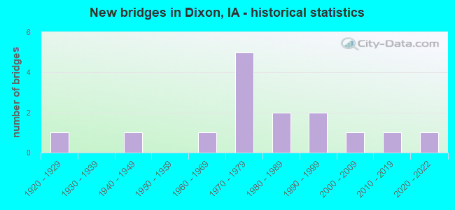
- New bridges - historical statistics
- 11920-1929
- 11940-1949
- 11960-1969
- 51970-1979
- 21980-1989
- 21990-1999
- 12000-2009
- 12010-2019
- 12020-2022
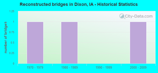
- Reconstructed bridges - Historical Statistics
- 11970-1979
- 11980-1989
- 01990-1999
- 12000-2009
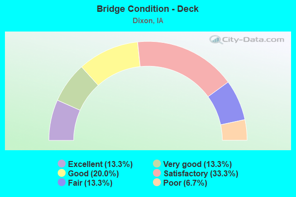
- Bridge Condition - Deck
- 13.3%Excellent
- 13.3%Very good
- 20.0%Good
- 33.3%Satisfactory
- 13.3%Fair
- 6.7%Poor
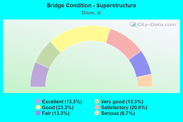
- Bridge Condition - Superstructure
- 13.3%Excellent
- 13.3%Very good
- 33.3%Good
- 20.0%Satisfactory
- 13.3%Fair
- 6.7%Serious
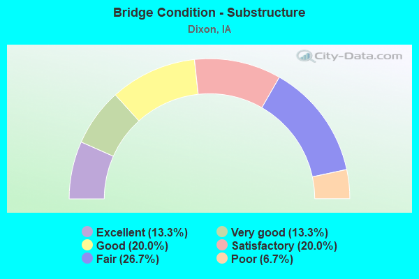
- Bridge Condition - Substructure
- 13.3%Excellent
- 13.3%Very good
- 20.0%Good
- 20.0%Satisfactory
- 26.7%Fair
- 6.7%Poor
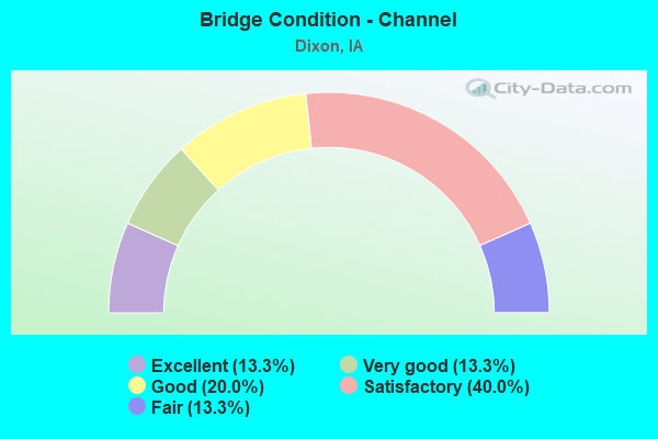
- Bridge Condition - Channel
- 13.3%Excellent
- 13.3%Very good
- 20.0%Good
- 40.0%Satisfactory
- 13.3%Fair
Find on map >> Show street view
Structure Number: 121901, Location: 081E13406 (Lat: 41.773244, Lng: -90.827686), Route carried "on" structure: County highway , Year Built: 2005, Status: Open, Structure Length: 3.81m (12.50ft), Average Daily Traffic: 1,170 (year 2018), Truck Traffic: 7%, Average Future Daily Traffic: 1,170 (year 2040), Design Load: HS 20, Features Intersected: WEST ROCK CREEK, Facility Carried by Structure: 130TH AVE
Minimum Vertical Clearance: 30+ m (98+ ft), Kilometerpoint: 0.201, Lanes on structure: 2, Owner: County Highway Agency, Approaching Roadway Width: 11.6m (38.1ft), Material/Design: Concrete continuous, Design/Construction: Slab, Number Of Spans In Main Unit: 3, Length of Maximum Span: 14.9m (48.9ft), Curb-To-Curb Width: 9.1m (29.9ft), Out-to-Out Width: 10.1m (33.1ft)
Condition: Deck: Very good, Superstructure: Very good, Substructure: Very good, Channel: Very good, Operating Rating: 77.0 metric tons, Method Used To Determine Operating Rating: Load Factor (LF), Inventory Rating: 43.7 metric tons, Method Used To Determine Inventory Rating: Load Factor (LF), Structural Evaluation: Equal to present desirable criteria, Deck Geometry: Somewhat better than minimum adequacy, Waterway Adequacy: Equal to present desirable criteria, Approach Roadway Alignment: Superior to present desirable criteria, Designated Inspection Frequency: Every 48 months, Inspection Date: Febuary 2020, Deck Structure Type: Concrete Cast-file-Place, Wearing Surface/Protective System: Wearing Surface: Monolithic Concrete
Find on map >> Show street view
Structure Number: 121932, Location: 081E13506 (Lat: 41.779028, Lng: -90.811703), Route carried "on" structure: County highway , Year Built: 2015, Status: Open, Structure Length: 2.44m (8.01ft), Average Daily Traffic: 25 (year 2018), Average Future Daily Traffic: 25 (year 2039), Design Load: HL 93, Features Intersected: ROCK CREEK, Facility Carried by Structure: 278TH ST
Minimum Vertical Clearance: 30+ m (98+ ft), Kilometerpoint: 1.078, Lanes on structure: 2, Owner: County Highway Agency, Approaching Roadway Width: 7.3m (24.0ft), Material/Design: Steel, Design/Construction: Stringer/Multi-beam, Number Of Spans In Main Unit: 1, Number Of Approach Spans: 2, Length of Maximum Span: 11.6m (38.1ft), Curb-To-Curb Width: 9.2m (30.2ft), Out-to-Out Width: 9.4m (30.8ft)
Condition: Deck: Excellent, Superstructure: Excellent, Substructure: Excellent, Channel: Excellent, Operating Rating: 59.6 metric tons, Method Used To Determine Operating Rating: Load and Resistance Factor Rating (LRFR) rating reported by rating factor(RF) method using HL-93 loadings, Inventory Rating: 42.4 metric tons, Method Used To Determine Inventory Rating: Load and Resistance Factor Rating (LRFR) rating reported by rating factor(RF) method using HL-93 loadings, Structural Evaluation: Superior to present desirable criteria, Deck Geometry: Better than present minimum criteria, Waterway Adequacy: Superior to present desirable criteria, Approach Roadway Alignment: Somewhat better than minimum adequacy, Designated Inspection Frequency: Every 48 months, Inspection Date: December 2019, Deck Structure Type: Concrete Cast-file-Place, Wearing Surface/Protective System: Wearing Surface: Monolithic Concrete
Find on map >> Show street view
Structure Number: 122011, Location: 081E23108 (Lat: 41.773925, Lng: -90.767333), Route carried "on" structure: County highway , Year Built: 2020, Status: Open, Structure Length: 1.07m (3.51ft), Average Daily Traffic: 80 (year 2014), Average Future Daily Traffic: 80 (year 2041), Design Load: HL 93, Features Intersected: CREEK, Facility Carried by Structure: 280TH ST
Minimum Vertical Clearance: 30+ m (98+ ft), Kilometerpoint: 6.738, Lanes on structure: 2, Owner: County Highway Agency, Approaching Roadway Width: 8.5m (27.9ft), Material/Design: Steel, Design/Construction: Stringer/Multi-beam, Number Of Spans In Main Unit: 1, Length of Maximum Span: 9.4m (30.8ft), Curb-To-Curb Width: 9.2m (30.2ft), Out-to-Out Width: 9.4m (30.8ft)
Condition: Deck: Excellent, Superstructure: Excellent, Substructure: Excellent, Channel: Excellent, Operating Rating: 97.2 metric tons, Method Used To Determine Operating Rating: Load and Resistance Factor Rating (LRFR) rating reported by rating factor(RF) method using HL-93 loadings, Inventory Rating: 97.2 metric tons, Method Used To Determine Inventory Rating: Load and Resistance Factor Rating (LRFR) rating reported by rating factor(RF) method using HL-93 loadings, Structural Evaluation: Superior to present desirable criteria, Deck Geometry: Better than present minimum criteria, Waterway Adequacy: Better than present minimum criteria, Approach Roadway Alignment: Equal to present desirable criteria, Designated Inspection Frequency: Every 48 months, Inspection Date: January 2021, Deck Structure Type: Concrete Cast-file-Place, Wearing Surface/Protective System: Wearing Surface: Monolithic Concrete
Find on map >> Show street view
Structure Number: 30301, Location: 080E10304 (Lat: 41.770158, Lng: -90.826714), Route carried "on" structure: County highway , Year Built: 1923, Year Reconstructed: 1970, Status: Open, Structure Length: 1.01m (3.31ft), Average Daily Traffic: 1,170 (year 2018), Truck Traffic: 7%, Average Future Daily Traffic: 1,170 (year 2041), Design Load: H 15, Features Intersected: CREEK, Facility Carried by Structure: BIG ROCK RD
Minimum Vertical Clearance: 30+ m (98+ ft), Kilometerpoint: 4.772, Lanes on structure: 2, Owner: County Highway Agency, Approaching Roadway Width: 8.5m (27.9ft), Skew: 3 degrees, Material/Design: Concrete, Design/Construction: Slab, Number Of Spans In Main Unit: 1, Length of Maximum Span: 9.4m (30.8ft), Curb-To-Curb Width: 8.5m (27.9ft), Out-to-Out Width: 8.6m (28.2ft)
Condition: Deck: Poor, Superstructure: Serious, Substructure: Fair, Channel: Fair, Operating Rating: 47.7 metric tons, Method Used To Determine Operating Rating: Allowable Stress (AS), Inventory Rating: 28.5 metric tons, Method Used To Determine Inventory Rating: Allowable Stress (AS), Structural Evaluation: High priority of corrective action, Deck Geometry: Somewhat better than minimum adequacy, Waterway Adequacy: Somewhat better than minimum adequacy, Approach Roadway Alignment: Equal to present minimum criteria, Length Of Structure Improvement: 7.00m (22.97ft), Designated Inspection Frequency: Every 12 months, Inspection Date: April 2021, Bridge Improvement Cost: $200,000, Roadway Improvement Cost: $20,000, Deck Structure Type: Concrete Cast-file-Place, Wearing Surface/Protective System: Wearing Surface: Bituminous
Find on map >> Show street view
Structure Number: 303081, Location: 080E11004 (Lat: 41.748861, Lng: -90.826233), Route carried "on" structure: County highway , Year Built: 1972, Status: Posted for load, Structure Length: 0.98m (3.22ft), Average Daily Traffic: 50 (year 2018), Average Future Daily Traffic: 50 (year 2041), Design Load: H 15, Features Intersected: CREEK, Facility Carried by Structure: 40TH AVE
Minimum Vertical Clearance: 30+ m (98+ ft), Kilometerpoint: 0.314, Lanes on structure: 2, Owner: County Highway Agency, Approaching Roadway Width: 6.7m (22.0ft), Material/Design: Concrete, Design/Construction: Slab, Number Of Spans In Main Unit: 1, Length of Maximum Span: 9.1m (29.9ft), Curb-To-Curb Width: 7.3m (24.0ft), Out-to-Out Width: 7.9m (25.9ft)
Condition: Deck: Satisfactory, Superstructure: Satisfactory, Substructure: Poor, Channel: Fair, Operating Rating: 24.0 metric tons, Method Used To Determine Operating Rating: Allowable Stress (AS), Inventory Rating: 15.1 metric tons, Method Used To Determine Inventory Rating: Allowable Stress (AS), Structural Evaluation: Meets minimum limits, Deck Geometry: Equal to present minimum criteria, Waterway Adequacy: Equal to present minimum criteria, Approach Roadway Alignment: Equal to present minimum criteria, Bridge Posting: Required (Relationship of Operating Rating to Maximum Legal Load: 10.0 - 19.9% below), Length Of Structure Improvement: 3.20m (10.50ft), Designated Inspection Frequency: Every 24 months, Inspection Date: April 2021, Bridge Improvement Cost: $17,000, Roadway Improvement Cost: $5,000, Deck Structure Type: Concrete Cast-file-Place, Wearing Surface/Protective System: Wearing Surface: Monolithic Concrete
Find on map >> Show street view
Structure Number: 303091, Location: 080E11208 (Lat: 41.745583, Lng: -90.786511), Route carried "on" structure: County highway , Year Built: 1949, Year Reconstructed: 1987, Status: Open, Structure Length: 3.17m (10.40ft), Average Daily Traffic: 1,170 (year 2018), Truck Traffic: 7%, Average Future Daily Traffic: 1,170 (year 2041), Design Load: HS 20, Features Intersected: WALNUT CREEK, Facility Carried by Structure: FM
Minimum Vertical Clearance: 30+ m (98+ ft), Kilometerpoint: 0.198, Lanes on structure: 2, Owner: County Highway Agency, Approaching Roadway Width: 10.4m (34.1ft), Material/Design: Steel, Design/Construction: Stringer/Multi-beam, Number Of Spans In Main Unit: 3, Length of Maximum Span: 10.4m (34.1ft), Curb-To-Curb Width: 9.1m (29.9ft), Out-to-Out Width: 9.4m (30.8ft)
Condition: Deck: Satisfactory, Superstructure: Good, Substructure: Fair, Channel: Satisfactory, Operating Rating: 54.9 metric tons, Method Used To Determine Operating Rating: Allowable Stress (AS), Inventory Rating: 35.1 metric tons, Method Used To Determine Inventory Rating: Allowable Stress (AS), Structural Evaluation: Somewhat better than minimum adequacy, Deck Geometry: Somewhat better than minimum adequacy, Waterway Adequacy: Better than present minimum criteria, Approach Roadway Alignment: Somewhat better than minimum adequacy, Length Of Structure Improvement: 10.40m (34.12ft), Designated Inspection Frequency: Every 24 months, Inspection Date: April 2021, Bridge Improvement Cost: $17,000, Roadway Improvement Cost: $5,000, Deck Structure Type: Concrete Cast-file-Place, Wearing Surface/Protective System: Wearing Surface: Monolithic Concrete
Find on map >> Show street view
Structure Number: 303101, Location: 080E11305 (Lat: 41.734867, Lng: -90.798417), Route carried "on" structure: County highway , Year Built: 1974, Status: Open, Structure Length: 3.17m (10.40ft), Average Daily Traffic: 220 (year 2018), Truck Traffic: 29%, Average Future Daily Traffic: 220 (year 2041), Features Intersected: CREEK, Facility Carried by Structure: 296TH ST
Minimum Vertical Clearance: 30+ m (98+ ft), Kilometerpoint: 2.086, Lanes on structure: 2, Owner: County Highway Agency, Approaching Roadway Width: 10.4m (34.1ft), Skew: 3 degrees, Material/Design: Concrete continuous, Design/Construction: Slab, Number Of Spans In Main Unit: 3, Length of Maximum Span: 11.9m (39.0ft), Curb-To-Curb Width: 9.1m (29.9ft), Out-to-Out Width: 9.8m (32.2ft)
Condition: Deck: Fair, Superstructure: Fair, Substructure: Satisfactory, Channel: Satisfactory, Operating Rating: 49.8 metric tons, Method Used To Determine Operating Rating: Allowable Stress (AS), Inventory Rating: 30.0 metric tons, Method Used To Determine Inventory Rating: Allowable Stress (AS), Structural Evaluation: Somewhat better than minimum adequacy, Deck Geometry: Equal to present minimum criteria, Waterway Adequacy: Better than present minimum criteria, Approach Roadway Alignment: Better than present minimum criteria, Length Of Structure Improvement: 10.40m (34.12ft), Designated Inspection Frequency: Every 24 months, Inspection Date: April 2021, Bridge Improvement Cost: $17,000, Roadway Improvement Cost: $5,000, Deck Structure Type: Concrete Cast-file-Place, Wearing Surface/Protective System: Wearing Surface: Monolithic Concrete
Find on map >> Show street view
Structure Number: 303111, Location: 080E11406 (Lat: 41.734203, Lng: -90.801944), Route carried "on" structure: County highway , Year Built: 1974, Status: Open, Structure Length: 1.74m (5.71ft), Average Daily Traffic: 20 (year 2018), Average Future Daily Traffic: 20 (year 2041), Design Load: H 20, Features Intersected: CREEK, Facility Carried by Structure: 50TH AVE
Minimum Vertical Clearance: 30+ m (98+ ft), Kilometerpoint: 9.139, Lanes on structure: 2, Owner: County Highway Agency, Approaching Roadway Width: 7.0m (23.0ft), Material/Design: Steel, Design/Construction: Stringer/Multi-beam, Number Of Spans In Main Unit: 1, Length of Maximum Span: 16.8m (55.1ft), Curb-To-Curb Width: 7.3m (24.0ft), Out-to-Out Width: 7.9m (25.9ft)
Condition: Deck: Satisfactory, Superstructure: Good, Substructure: Fair, Channel: Satisfactory, Operating Rating: 46.7 metric tons, Method Used To Determine Operating Rating: Load Factor (LF), Inventory Rating: 27.9 metric tons, Method Used To Determine Inventory Rating: Load Factor (LF), Structural Evaluation: Somewhat better than minimum adequacy, Deck Geometry: Equal to present minimum criteria, Waterway Adequacy: Better than present minimum criteria, Approach Roadway Alignment: Equal to present minimum criteria, Length Of Structure Improvement: 5.70m (18.70ft), Designated Inspection Frequency: Every 24 months, Inspection Date: April 2021, Bridge Improvement Cost: $17,000, Roadway Improvement Cost: $5,000, Deck Structure Type: Concrete Cast-file-Place, Wearing Surface/Protective System: Wearing Surface: Monolithic Concrete
Find on map >> Show street view
Structure Number: 303191, Location: 080E20602 (Lat: 41.767703, Lng: -90.782183), Route carried "on" structure: County highway , Year Built: 1982, Status: Open, Structure Length: 10.97m (35.99ft), Average Daily Traffic: 70 (year 2018), Average Future Daily Traffic: 70 (year 2041), Design Load: H 20, Features Intersected: WAPSIPINICON RIVER, Facility Carried by Structure: 57TH AVE
Minimum Vertical Clearance: 30+ m (98+ ft), Kilometerpoint: 0.000, Lanes on structure: 2, Owner: County Highway Agency, Approaching Roadway Width: 8.5m (27.9ft), Skew: 1 degrees, Material/Design: Steel continuous, Design/Construction: Stringer/Multi-beam, Number Of Spans In Main Unit: 4, Length of Maximum Span: 29.9m (98.1ft), Curb or Sidewalk Widths: Left: 0.3m (1.0ft), Right: 0.3m (1.0ft), Curb-To-Curb Width: 8.5m (27.9ft), Out-to-Out Width: 9.1m (29.9ft)
Condition: Deck: Satisfactory, Superstructure: Satisfactory, Substructure: Satisfactory, Channel: Good, Operating Rating: 39.4 metric tons, Method Used To Determine Operating Rating: Allowable Stress (AS), Inventory Rating: 27.3 metric tons, Method Used To Determine Inventory Rating: Allowable Stress (AS), Structural Evaluation: Equal to present minimum criteria, Deck Geometry: Better than present minimum criteria, Waterway Adequacy: Better than present minimum criteria, Approach Roadway Alignment: Equal to present minimum criteria, Length Of Structure Improvement: 36.00m (118.11ft), Designated Inspection Frequency: Every 24 months, Underwater Inspection Frequency: Every 48 months, Other Special Inspection Frequency: Every 60 months, Inspection Date: April 2021, Underwater Inspection Date: September 2020, Other Special Inspection Date: July 2017, Bridge Improvement Cost: $17,000, Roadway Improvement Cost: $5,000, Deck Structure Type: Concrete Cast-file-Place, Wearing Surface/Protective System: Wearing Surface: Monolithic Concrete
Find on map >> Show street view
Structure Number: 30326, Location: 080E21702 (Lat: 41.738450, Lng: -90.762756), Route carried "on" structure: County highway , Year Built: 1968, Status: Open, Structure Length: 3.17m (10.40ft), Average Daily Traffic: 25 (year 2018), Average Future Daily Traffic: 25 (year 2041), Design Load: H 20, Features Intersected: CREEK, Facility Carried by Structure: 70TH AVE
Minimum Vertical Clearance: 30+ m (98+ ft), Kilometerpoint: 15.714, Lanes on structure: 2, Owner: County Highway Agency, Approaching Roadway Width: 9.8m (32.2ft), Skew: 3 degrees, Material/Design: Concrete continuous, Design/Construction: Slab, Number Of Spans In Main Unit: 3, Length of Maximum Span: 11.9m (39.0ft), Curb-To-Curb Width: 8.5m (27.9ft), Out-to-Out Width: 9.1m (29.9ft)
Condition: Deck: Fair, Superstructure: Fair, Substructure: Fair, Channel: Satisfactory, Operating Rating: 50.2 metric tons, Method Used To Determine Operating Rating: Allowable Stress (AS), Inventory Rating: 30.6 metric tons, Method Used To Determine Inventory Rating: Allowable Stress (AS), Structural Evaluation: Somewhat better than minimum adequacy, Deck Geometry: Better than present minimum criteria, Waterway Adequacy: Better than present minimum criteria, Approach Roadway Alignment: Better than present minimum criteria, Length Of Structure Improvement: 10.40m (34.12ft), Designated Inspection Frequency: Every 24 months, Inspection Date: April 2021, Bridge Improvement Cost: $17,000, Roadway Improvement Cost: $5,000, Deck Structure Type: Concrete Cast-file-Place, Wearing Surface/Protective System: Wearing Surface: Monolithic Concrete
Find on map >> Show street view
Structure Number: 303311, Location: 080E22903 (Lat: 41.711469, Lng: -90.743397), Route carried "on" structure: County highway , Year Built: 1987, Status: Open, Structure Length: 5.52m (18.11ft), Average Daily Traffic: 630 (year 2018), Truck Traffic: 10%, Average Future Daily Traffic: 630 (year 2039), Design Load: HS 20, Features Intersected: MUD CREEK, Facility Carried by Structure: ALLENS GROVE RD
Minimum Vertical Clearance: 30+ m (98+ ft), Kilometerpoint: 9.342, Lanes on structure: 2, Owner: County Highway Agency, Approaching Roadway Width: 6.7m (22.0ft), Material/Design: Concrete continuous, Design/Construction: Slab, Number Of Spans In Main Unit: 5, Length of Maximum Span: 11.9m (39.0ft), Curb-To-Curb Width: 9.1m (29.9ft), Out-to-Out Width: 10.1m (33.1ft)
Condition: Deck: Good, Superstructure: Good, Substructure: Good, Channel: Good, Operating Rating: 62.7 metric tons, Method Used To Determine Operating Rating: Load Factor (LF), Inventory Rating: 37.6 metric tons, Method Used To Determine Inventory Rating: Load Factor (LF), Structural Evaluation: Better than present minimum criteria, Deck Geometry: Equal to present minimum criteria, Waterway Adequacy: Equal to present desirable criteria, Approach Roadway Alignment: Equal to present minimum criteria, Length Of Structure Improvement: 18.00m (59.06ft), Designated Inspection Frequency: Every 48 months, Inspection Date: April 2019, Bridge Improvement Cost: $17,000, Roadway Improvement Cost: $5,000, Deck Structure Type: Concrete Cast-file-Place, Wearing Surface/Protective System: Wearing Surface: Monolithic Concrete
Find on map >> Show street view
Structure Number: 303321, Location: 080E22904 (Lat: 41.704428, Lng: -90.759564), Route carried "on" structure: County highway , Year Built: 1976, Year Reconstructed: 2013, Status: Open, Structure Length: 0.76m (2.49ft), Average Daily Traffic: 15 (year 2018), Average Future Daily Traffic: 15 (year 2041), Design Load: H 20, Features Intersected: STREAM, Facility Carried by Structure: 275TH ST
Minimum Vertical Clearance: 30+ m (98+ ft), Kilometerpoint: 2.113, Lanes on structure: 2, Owner: County Highway Agency, Approaching Roadway Width: 7.9m (25.9ft), Material/Design: Prestressed concrete, Design/Construction: Tee Beam, Number Of Spans In Main Unit: 1, Length of Maximum Span: 7.3m (24.0ft), Curb-To-Curb Width: 7.3m (24.0ft), Out-to-Out Width: 7.9m (25.9ft)
Condition: Deck: Good, Superstructure: Good, Substructure: Good, Channel: Satisfactory, Operating Rating: 30.8 metric tons, Method Used To Determine Operating Rating: Field evaluation and documented engineering judgment, Inventory Rating: 22.7 metric tons, Method Used To Determine Inventory Rating: Field evaluation and documented engineering judgment, Structural Evaluation: Equal to present minimum criteria, Deck Geometry: Equal to present minimum criteria, Waterway Adequacy: Somewhat better than minimum adequacy, Approach Roadway Alignment: Equal to present minimum criteria, Length Of Structure Improvement: 4.50m (14.76ft), Designated Inspection Frequency: Every 24 months, Inspection Date: April 2021, Bridge Improvement Cost: $102,000, Roadway Improvement Cost: $10,000, Deck Structure Type: Concrete Precast Panels, Wearing Surface/Protective System: Wearing Surface: Monolithic Concrete
Find on map >> Show street view
Structure Number: 303331, Location: 080E22906 (Lat: 41.698514, Lng: -90.757286), Route carried "on" structure: County highway , Year Built: 1972, Status: Posted for load, Structure Length: 4.69m (15.39ft), Average Daily Traffic: 30 (year 2018), Average Future Daily Traffic: 30 (year 2041), Design Load: H 15, Features Intersected: CREEK, Facility Carried by Structure: 75TH AVE
Minimum Vertical Clearance: 30+ m (98+ ft), Kilometerpoint: 1.959, Lanes on structure: 2, Owner: County Highway Agency, Approaching Roadway Width: 9.1m (29.9ft), Material/Design: Steel continuous, Design/Construction: Stringer/Multi-beam, Number Of Spans In Main Unit: 3, Length of Maximum Span: 15.2m (49.9ft), Curb-To-Curb Width: 7.3m (24.0ft), Out-to-Out Width: 7.9m (25.9ft)
Condition: Deck: Satisfactory, Superstructure: Satisfactory, Substructure: Satisfactory, Channel: Satisfactory, Operating Rating: 33.5 metric tons, Method Used To Determine Operating Rating: Load Factor (LF), Inventory Rating: 20.0 metric tons, Method Used To Determine Inventory Rating: Load Factor (LF), Structural Evaluation: Somewhat better than minimum adequacy, Deck Geometry: Equal to present minimum criteria, Waterway Adequacy: Better than present minimum criteria, Approach Roadway Alignment: Equal to present minimum criteria, Bridge Posting: Required (Relationship of Operating Rating to Maximum Legal Load: 0.1 - 9.9% below), Length Of Structure Improvement: 15.40m (50.52ft), Designated Inspection Frequency: Every 24 months, Inspection Date: April 2021, Bridge Improvement Cost: $17,000, Roadway Improvement Cost: $5,000, Deck Structure Type: Concrete Cast-file-Place, Wearing Surface/Protective System: Wearing Surface: Monolithic Concrete
Find on map >> Show street view
Structure Number: 303351, Location: 080E23102 (Lat: 41.689958, Lng: -90.782525), Route carried "on" structure: County highway , Year Built: 1994, Status: Open, Structure Length: 2.38m (7.81ft), Average Daily Traffic: 1,320 (year 2018), Truck Traffic: 22%, Average Future Daily Traffic: 1,320 (year 2039), Design Load: HS 20, Features Intersected: CREEK, Facility Carried by Structure: 60TH AVE
Minimum Vertical Clearance: 30+ m (98+ ft), Kilometerpoint: 14.914, Lanes on structure: 2, Owner: County Highway Agency, Approaching Roadway Width: 11.0m (36.1ft), Skew: 4 degrees, Material/Design: Concrete continuous, Design/Construction: Slab, Number Of Spans In Main Unit: 3, Length of Maximum Span: 8.8m (28.9ft), Curb-To-Curb Width: 9.3m (30.5ft), Out-to-Out Width: 10.1m (33.1ft)
Condition: Deck: Very good, Superstructure: Very good, Substructure: Good, Channel: Very good, Operating Rating: 62.2 metric tons, Method Used To Determine Operating Rating: Allowable Stress (AS), Inventory Rating: 37.1 metric tons, Method Used To Determine Inventory Rating: Allowable Stress (AS), Structural Evaluation: Better than present minimum criteria, Deck Geometry: Somewhat better than minimum adequacy, Waterway Adequacy: Equal to present desirable criteria, Approach Roadway Alignment: Equal to present desirable criteria, Length Of Structure Improvement: 7.80m (25.59ft), Designated Inspection Frequency: Every 48 months, Inspection Date: April 2019, Bridge Improvement Cost: $17,000, Roadway Improvement Cost: $5,000, Deck Structure Type: Concrete Cast-file-Place, Wearing Surface/Protective System: Wearing Surface: Monolithic Concrete
Find on map >> Show street view
Structure Number: 303361, Location: 080E23102 (Lat: 41.695817, Lng: -90.782497), Route carried "on" structure: County highway , Year Built: 1998, Status: Open, Structure Length: 2.29m (7.51ft), Average Daily Traffic: 1,320 (year 2018), Truck Traffic: 22%, Average Future Daily Traffic: 1,320 (year 2039), Design Load: HS 20, Features Intersected: CREEK, Facility Carried by Structure: 60TH AVE
Minimum Vertical Clearance: 30+ m (98+ ft), Kilometerpoint: 15.564, Lanes on structure: 2, Owner: County Highway Agency, Approaching Roadway Width: 10.4m (34.1ft), Material/Design: Concrete continuous, Design/Construction: Slab, Number Of Spans In Main Unit: 3, Length of Maximum Span: 8.8m (28.9ft), Curb-To-Curb Width: 9.3m (30.5ft), Out-to-Out Width: 10.1m (33.1ft)
Condition: Deck: Good, Superstructure: Good, Substructure: Very good, Channel: Good, Operating Rating: 76.3 metric tons, Method Used To Determine Operating Rating: Load Factor (LF), Inventory Rating: 45.7 metric tons, Method Used To Determine Inventory Rating: Load Factor (LF), Structural Evaluation: Better than present minimum criteria, Deck Geometry: Somewhat better than minimum adequacy, Waterway Adequacy: Equal to present minimum criteria, Approach Roadway Alignment: Equal to present desirable criteria, Length Of Structure Improvement: 7.50m (24.61ft), Designated Inspection Frequency: Every 48 months, Inspection Date: April 2019, Bridge Improvement Cost: $17,000, Roadway Improvement Cost: $5,000, Deck Structure Type: Concrete Cast-file-Place, Wearing Surface/Protective System: Wearing Surface: Monolithic Concrete