Bridge Statistics for Donegal, Pennsylvania (PA)
Condition, Traffic, Stress, Structural Evaluation, Project Costs
- National Bridge Inventory (NBI) Statistics
- 38Number of bridges
- 184ft / 56.3mTotal length
- $3,367,000Total costs
- 298,617Total average daily traffic
- 92,195Total average daily truck traffic
- National Bridge Inventory (NBI) Registered Bridges for Donegal
- No street view available for this location
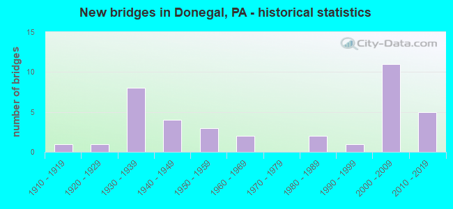
- New bridges - historical statistics
- 11910-1919
- 11920-1929
- 81930-1939
- 41940-1949
- 31950-1959
- 21960-1969
- 21980-1989
- 11990-1999
- 112000-2009
- 52010-2019

- Reconstructed bridges - Historical Statistics
- 11940-1949
- 01950-1959
- 11960-1969
- 01970-1979
- 11980-1989
- 31990-1999
- 02000-2009
- 12010-2019


- Bridge Condition - Deck
- 3.8%Excellent
- 11.5%Very good
- 23.1%Good
- 30.8%Satisfactory
- 23.1%Fair
- 7.7%Poor

- Bridge Condition - Superstructure
- 3.7%Excellent
- 11.1%Very good
- 40.7%Good
- 14.8%Satisfactory
- 22.2%Fair
- 7.4%Poor

- Bridge Condition - Substructure
- 3.7%Excellent
- 7.4%Very good
- 14.8%Good
- 40.7%Satisfactory
- 18.5%Fair
- 14.8%Poor

- Bridge Condition - Channel
- 4.2%Very good
- 20.8%Good
- 16.7%Satisfactory
- 45.8%Fair
- 12.5%Poor

- Bridge Condition - Culverts
- 25.0%Very good
- 25.0%Good
- 50.0%Fair
Find on map >> Show street view
Structure Number: 16685, Location: SALTLICK TOWNSHIP (Lat: 40.051444, Lng: -79.390117), Route carried "on" structure: State highway 381, Year Built: 1942, Status: Open, Structure Length: 1.34m (4.40ft), Average Daily Traffic: 2,319 (year 2020), Truck Traffic: 11%, Average Future Daily Traffic: 3,102 (year 2032), Design Load: H 20, Features Intersected: CHAMPION CREEK
Minimum Vertical Clearance: 30+ m (98+ ft), Kilometerpoint: 50.894, Lanes on structure: 2, Base Highway Network: Yes, Owner: State Highway Agency, Approaching Roadway Width: 8.2m (26.9ft), Material/Design: Concrete, Design/Construction: Tee Beam, Number Of Spans In Main Unit: 1, Length of Maximum Span: 12.2m (40.0ft), Curb or Sidewalk Widths: Left: 0.2m (0.7ft), Right: 1.7m (5.6ft), Curb-To-Curb Width: 8.8m (28.9ft), Out-to-Out Width: 9.7m (31.8ft)
Condition: Deck: Satisfactory, Superstructure: Satisfactory, Substructure: Fair, Channel: Poor, Operating Rating: 58.1 metric tons, Method Used To Determine Operating Rating: Load Factor (LF), Inventory Rating: 34.5 metric tons, Method Used To Determine Inventory Rating: Load Factor (LF), Structural Evaluation: Somewhat better than minimum adequacy, Deck Geometry: Meets minimum limits, Waterway Adequacy: Equal to present minimum criteria, Approach Roadway Alignment: Equal to present desirable criteria, Length Of Structure Improvement: 2.00m (6.56ft), Designated Inspection Frequency: Every 24 months, Inspection Date: December 2020, Deck Structure Type: Concrete Cast-file-Place, Wearing Surface/Protective System: Wearing Surface: Bituminous
Find on map >> Show street view
Structure Number: 16793, Location: SALTLICK TOWNSHIP (Lat: 40.075461, Lng: -79.412861), Route carried "on" structure: State highway , Year Built: 1938, Year Reconstructed: 1954, Status: Open, Structure Length: 0.88m (2.89ft), Average Daily Traffic: 1,336 (year 2022), Truck Traffic: 6%, Average Future Daily Traffic: 1,265 (year 2032), Design Load: HS 20, Features Intersected: LITTLE CHAMPION CREEK, Facility Carried by Structure: SR 1050
Minimum Vertical Clearance: 30+ m (98+ ft), Kilometerpoint: 14.515, Lanes on structure: 2, Owner: State Highway Agency, Approaching Roadway Width: 7.9m (25.9ft), Skew: 1 degrees, Material/Design: Steel, Design/Construction: Stringer/Multi-beam, Number Of Spans In Main Unit: 1, Length of Maximum Span: 8.5m (27.9ft), Curb or Sidewalk Widths: Left: 0.2m (0.7ft), Right: 0.2m (0.7ft), Curb-To-Curb Width: 9.1m (29.9ft), Out-to-Out Width: 9.8m (32.2ft)
Condition: Deck: Satisfactory, Superstructure: Fair, Substructure: Satisfactory, Channel: Satisfactory, Operating Rating: 49.9 metric tons, Method Used To Determine Operating Rating: Load Factor (LF), Inventory Rating: 29.9 metric tons, Method Used To Determine Inventory Rating: Load Factor (LF), Structural Evaluation: Somewhat better than minimum adequacy, Deck Geometry: Somewhat better than minimum adequacy, Waterway Adequacy: Equal to present minimum criteria, Approach Roadway Alignment: Equal to present desirable criteria, Length Of Structure Improvement: 1.60m (5.25ft), Designated Inspection Frequency: Every 24 months, Inspection Date: January 2021, Deck Structure Type: Concrete Cast-file-Place, Wearing Surface/Protective System: Wearing Surface: Bituminous
Find on map >> Show street view
Structure Number: 16838, Location: SALTLICK & DONEGAL TWPS. (Lat: 40.096431, Lng: -79.398122), Route carried "on" structure: State highway , Year Built: 1948, Status: Open, Structure Length: 0.76m (2.49ft), Average Daily Traffic: 1,263 (year 2020), Truck Traffic: 7%, Average Future Daily Traffic: 1,933 (year 2032), Design Load: HS 20+Mod, Features Intersected: CHAMPION CREEK, Facility Carried by Structure: SR 1058
Minimum Vertical Clearance: 30+ m (98+ ft), Kilometerpoint: 6.222, Lanes on structure: 2, Owner: State Highway Agency, Approaching Roadway Width: 7.0m (23.0ft), Skew: 3 degrees, Material/Design: Concrete, Design/Construction: Tee Beam, Number Of Spans In Main Unit: 1, Length of Maximum Span: 7.3m (24.0ft), Curb or Sidewalk Widths: Left: 0.2m (0.7ft), Right: 0.2m (0.7ft), Curb-To-Curb Width: 7.3m (24.0ft), Out-to-Out Width: 8.4m (27.6ft)
Condition: Deck: Satisfactory, Superstructure: Satisfactory, Substructure: Fair, Channel: Satisfactory, Operating Rating: 59.9 metric tons, Method Used To Determine Operating Rating: Load Factor (LF), Inventory Rating: 35.4 metric tons, Method Used To Determine Inventory Rating: Load Factor (LF), Structural Evaluation: Somewhat better than minimum adequacy, Deck Geometry: Meets minimum limits, Waterway Adequacy: Superior to present desirable criteria, Approach Roadway Alignment: Equal to present desirable criteria, Length Of Structure Improvement: 1.50m (4.92ft), Designated Inspection Frequency: Every 24 months, Inspection Date: Febuary 2021, Deck Structure Type: Concrete Cast-file-Place, Wearing Surface/Protective System: Wearing Surface: Bituminous
Find on map >> Show street view
Structure Number: 17122, Location: WEST OF CHAMPION (Lat: 40.077947, Lng: -79.380381), Route carried "on" structure: Alternate City street T722, Year Built: 1935, Status: Open, Structure Length: 0.76m (2.49ft), Average Daily Traffic: 150 (year 1992), Average Future Daily Traffic: 50 (year 1985), Design Load: H 20, Features Intersected: CHAMPION CREEK, Facility Carried by Structure: RED DOG ROAD
Minimum Vertical Clearance: 30+ m (98+ ft), Kilometerpoint: 0.000, Lanes on structure: 2, Owner: Town or Township Highway Agency, Approaching Roadway Width: 5.2m (17.1ft), Skew: 1 degrees, Material/Design: Concrete, Design/Construction: Tee Beam, Number Of Spans In Main Unit: 1, Length of Maximum Span: 7.3m (24.0ft), Curb-To-Curb Width: 7.4m (24.3ft), Out-to-Out Width: 8.4m (27.6ft)
Condition: Deck: Fair, Superstructure: Fair, Substructure: Fair, Channel: Fair, Operating Rating: 51.7 metric tons, Method Used To Determine Operating Rating: Load Factor (LF), Inventory Rating: 30.8 metric tons, Method Used To Determine Inventory Rating: Load Factor (LF), Structural Evaluation: Somewhat better than minimum adequacy, Deck Geometry: Somewhat better than minimum adequacy, Waterway Adequacy: Equal to present desirable criteria, Approach Roadway Alignment: Equal to present minimum criteria, Length Of Structure Improvement: 0.80m (2.62ft), Designated Inspection Frequency: Every 24 months, Inspection Date: April 2020, Bridge Improvement Cost: $4,000, Roadway Improvement Cost: $28,000, Total Project Cost: $52,000, Deck Structure Type: Concrete Cast-file-Place, Wearing Surface/Protective System: Wearing Surface: Bituminous
Find on map >> Show street view
Structure Number: 17126, Location: 150' W OF MELCROFT ROAD (Lat: 40.067789, Lng: -79.399578), Route carried "on" structure: City street , Year Built: 1950, Status: Posted for load, Structure Length: 0.76m (2.49ft), Average Daily Traffic: 190 (year 2013), Average Future Daily Traffic: 240 (year 2033), Design Load: H 20, Features Intersected: CHAMPION CREEK, Facility Carried by Structure: ALBRIGHT ROAD
Minimum Vertical Clearance: 30+ m (98+ ft), Kilometerpoint: 0.000, Lanes on structure: 2, Owner: Town or Township Highway Agency, Approaching Roadway Width: 4.0m (13.1ft), Skew: 1 degrees, Material/Design: Steel, Design/Construction: Stringer/Multi-beam, Number Of Spans In Main Unit: 1, Length of Maximum Span: 6.7m (22.0ft), Curb-To-Curb Width: 5.4m (17.7ft), Out-to-Out Width: 5.7m (18.7ft)
Condition: Deck: Fair, Superstructure: Poor, Substructure: Poor, Channel: Fair, Operating Rating: 36.3 metric tons, Method Used To Determine Operating Rating: Load Factor (LF), Inventory Rating: 21.8 metric tons, Method Used To Determine Inventory Rating: Load Factor (LF), Structural Evaluation: Meets minimum limits, Deck Geometry: High priority of replacement, Waterway Adequacy: Better than present minimum criteria, Approach Roadway Alignment: Somewhat better than minimum adequacy, Bridge Posting: Required (Relationship of Operating Rating to Maximum Legal Load: 10.0 - 19.9% below), Length Of Structure Improvement: 0.80m (2.62ft), Designated Inspection Frequency: Every 24 months, Other Special Inspection Frequency: Every 12 months, Inspection Date: April 2020, Other Special Inspection Date: April 2021, Bridge Improvement Cost: $1,000, Roadway Improvement Cost: $3,000, Total Project Cost: $15,000, Deck Structure Type: Open Grating
Find on map >> Show street view
Structure Number: 17127, Location: EAST OF ROUTE 381 (Lat: 40.059547, Lng: -79.365028), Route carried "on" structure: City street T729, Year Built: 1994, Status: Open, Structure Length: 1.58m (5.18ft), Average Daily Traffic: 115 (year 2006), Truck Traffic: 5%, Average Future Daily Traffic: 161 (year 2012), Design Load: HS 25 or greater, Features Intersected: INDIAN CREEK, Facility Carried by Structure: NEBO ROAD
Minimum Vertical Clearance: 30+ m (98+ ft), Kilometerpoint: 0.000, Lanes on structure: 2, Owner: County Highway Agency, Approaching Roadway Width: 6.7m (22.0ft), Skew: 1 degrees, Material/Design: Prestressed concrete, Design/Construction: Box Beam or Girders - Single/Spread, Number Of Spans In Main Unit: 1, Length of Maximum Span: 15.2m (49.9ft), Curb or Sidewalk Widths: Left: 0.2m (0.7ft), Right: 0.2m (0.7ft), Curb-To-Curb Width: 6.7m (22.0ft), Out-to-Out Width: 7.8m (25.6ft)
Condition: Deck: Good, Superstructure: Good, Substructure: Satisfactory, Channel: Fair, Operating Rating: 68.0 metric tons, Method Used To Determine Operating Rating: Load Factor (LF), Inventory Rating: 39.9 metric tons, Method Used To Determine Inventory Rating: Load Factor (LF), Structural Evaluation: Equal to present minimum criteria, Deck Geometry: Meets minimum limits, Waterway Adequacy: Superior to present desirable criteria, Approach Roadway Alignment: Equal to present desirable criteria, Length Of Structure Improvement: 2.10m (6.89ft), Designated Inspection Frequency: Every 24 months, Inspection Date: September 2021, Bridge Improvement Cost: $8,000, Roadway Improvement Cost: $25,000, Total Project Cost: $113,000, Deck Structure Type: Corrugated Steel, Wearing Surface/Protective System: Wearing Surface: Monolithic Concrete, Deck Protection: Epoxy Coated Reinforcing
Find on map >> Show street view
Structure Number: 17128, Location: 225' E OF SR 381/711 (Lat: 40.070675, Lng: -79.357883), Route carried "on" structure: ServiceCity street T733, Year Built: 1940, Status: Posted for load, Structure Length: 1.31m (4.30ft), Average Daily Traffic: 10 (year 2013), Average Future Daily Traffic: 12 (year 2033), Design Load: H 15, Features Intersected: INDIAN CREEK, Facility Carried by Structure: DURSTINE ROAD
Minimum Vertical Clearance: 30+ m (98+ ft), Kilometerpoint: 0.000, Lanes on structure: 1, Owner: Town or Township Highway Agency, Approaching Roadway Width: 2.7m (8.9ft), Skew: 1 degrees, Material/Design: Steel, Design/Construction: Stringer/Multi-beam, Number Of Spans In Main Unit: 1, Length of Maximum Span: 12.8m (42.0ft), Curb-To-Curb Width: 3.7m (12.1ft), Out-to-Out Width: 4.3m (14.1ft)
Condition: Deck: Poor, Superstructure: Fair, Substructure: Fair, Channel: Satisfactory, Operating Rating: 28.1 metric tons, Method Used To Determine Operating Rating: Allowable Stress (AS), Inventory Rating: 18.1 metric tons, Method Used To Determine Inventory Rating: Allowable Stress (AS), Structural Evaluation: Somewhat better than minimum adequacy, Deck Geometry: Meets minimum limits, Waterway Adequacy: Equal to present desirable criteria, Approach Roadway Alignment: Equal to present desirable criteria, Bridge Posting: Required (Relationship of Operating Rating to Maximum Legal Load: > 39.9% below), Length Of Structure Improvement: 1.30m (4.27ft), Designated Inspection Frequency: Every 24 months, Other Special Inspection Frequency: Every 12 months, Inspection Date: April 2020, Other Special Inspection Date: April 2021, Bridge Improvement Cost: $1,000, Roadway Improvement Cost: $3,000, Total Project Cost: $8,000, Deck Structure Type: Wood or Timber, Wearing Surface/Protective System: Wearing Surface: Wood or Timber
Find on map >> Show street view
Structure Number: 17129, Location: .5 MI.EAST OF MELCROFT (Lat: 40.051953, Lng: -79.382092), Route carried "on" structure: City street , Year Built: 1960, Status: Open, Structure Length: 1.01m (3.31ft), Average Daily Traffic: 100 (year 2007), Average Future Daily Traffic: 110 (year 2027), Design Load: HS 20, Features Intersected: INDIAN CREEK, Facility Carried by Structure: FOWL HILL ROAD
Minimum Vertical Clearance: 30+ m (98+ ft), Kilometerpoint: 0.000, Lanes on structure: 1, Owner: Town or Township Highway Agency, Approaching Roadway Width: 4.3m (14.1ft), Material/Design: Steel, Design/Construction: Stringer/Multi-beam, Number Of Spans In Main Unit: 1, Length of Maximum Span: 9.4m (30.8ft), Curb-To-Curb Width: 4.9m (16.1ft), Out-to-Out Width: 5.2m (17.1ft)
Condition: Deck: Fair, Superstructure: Satisfactory, Substructure: Satisfactory, Channel: Fair, Operating Rating: 52.6 metric tons, Method Used To Determine Operating Rating: Load Factor (LF), Inventory Rating: 30.8 metric tons, Method Used To Determine Inventory Rating: Load Factor (LF), Structural Evaluation: Equal to present minimum criteria, Deck Geometry: High priority of corrective action, Waterway Adequacy: Better than present minimum criteria, Approach Roadway Alignment: Better than present minimum criteria, Length Of Structure Improvement: 0.80m (2.62ft), Designated Inspection Frequency: Every 24 months, Inspection Date: April 2020, Roadway Improvement Cost: $1,000, Total Project Cost: $4,000, Deck Structure Type: Open Grating
Find on map >> Show street view
Structure Number: 35986, Location: DONEGAL TOWNSHIP (Lat: 40.087858, Lng: -79.334944), Route carried "on" structure: State highway 31, Year Built: 1941, Status: Open, Structure Length: 1.80m (5.91ft), Average Daily Traffic: 3,840 (year 2021), Truck Traffic: 11%, Average Future Daily Traffic: 5,129 (year 2032), Design Load: HS 20+Mod, Features Intersected: INDIAN CREEK
Minimum Vertical Clearance: 30+ m (98+ ft), Kilometerpoint: 39.933, Lanes on structure: 2, Base Highway Network: Yes, Owner: State Highway Agency, Approaching Roadway Width: 6.7m (22.0ft), Skew: 1 degrees, Material/Design: Concrete, Design/Construction: Culvert, Number Of Spans In Main Unit: 1, Length of Maximum Span: 18.0m (59.1ft)
Condition: Channel: Fair, Culverts: Fair, Operating Rating: 49.0 metric tons, Method Used To Determine Operating Rating: Field evaluation and documented engineering judgment, Inventory Rating: 32.7 metric tons, Method Used To Determine Inventory Rating: Field evaluation and documented engineering judgment, Structural Evaluation: Somewhat better than minimum adequacy, Waterway Adequacy: Superior to present desirable criteria, Approach Roadway Alignment: Equal to present desirable criteria, Length Of Structure Improvement: 1.80m (5.91ft), Designated Inspection Frequency: Every 24 months, Inspection Date: April 2021, Bridge Improvement Cost: $56,000, Roadway Improvement Cost: $200,000, Total Project Cost: $750,000
Find on map >> Show street view
Structure Number: 36108, Location: COOK & DONEGAL TOWNSHIP (Lat: 40.171717, Lng: -79.365319), Route carried "on" structure: State highway 130, Year Built: 1952, Status: Open, Structure Length: 1.83m (6.00ft), Average Daily Traffic: 695 (year 2021), Truck Traffic: 4%, Average Future Daily Traffic: 266 (year 2032), Design Load: H 20, Features Intersected: FOUR MILE RUN
Minimum Vertical Clearance: 30+ m (98+ ft), Kilometerpoint: 47.452, Lanes on structure: 2, Owner: State Highway Agency, Approaching Roadway Width: 6.1m (20.0ft), Material/Design: Steel, Design/Construction: Stringer/Multi-beam, Number Of Spans In Main Unit: 1, Length of Maximum Span: 17.4m (57.1ft), Curb or Sidewalk Widths: Left: 0.2m (0.7ft), Right: 0.2m (0.7ft), Curb-To-Curb Width: 7.3m (24.0ft), Out-to-Out Width: 8.2m (26.9ft)
Condition: Deck: Fair, Superstructure: Fair, Substructure: Satisfactory, Channel: Poor, Operating Rating: 55.3 metric tons, Method Used To Determine Operating Rating: Load Factor (LF), Inventory Rating: 32.7 metric tons, Method Used To Determine Inventory Rating: Load Factor (LF), Structural Evaluation: Somewhat better than minimum adequacy, Deck Geometry: Meets minimum limits, Waterway Adequacy: Equal to present minimum criteria, Approach Roadway Alignment: Equal to present desirable criteria, Length Of Structure Improvement: 2.50m (8.20ft), Designated Inspection Frequency: Every 24 months, Inspection Date: May 2021, Deck Structure Type: Concrete Cast-file-Place, Wearing Surface/Protective System: Wearing Surface: Bituminous
Find on map >> Show street view
Structure Number: 36219, Location: DONEGAL TOWNSHIP (Lat: 40.089406, Lng: -79.335356), Route carried "on" structure: State highway 381, Year Built: 1962, Year Reconstructed: 2019, Status: Open, Structure Length: 2.53m (8.30ft), Average Daily Traffic: 332 (year 2021), Truck Traffic: 18%, Average Future Daily Traffic: 508 (year 2032), Design Load: HL 93, Features Intersected: INDIAN CREEK
Minimum Vertical Clearance: 30+ m (98+ ft), Kilometerpoint: 2.029, Lanes on structure: 2, Owner: State Highway Agency, Approaching Roadway Width: 5.5m (18.0ft), Material/Design: Prestressed concrete continuous, Design/Construction: Box Beam or Girders - Single/Spread, Number Of Spans In Main Unit: 2, Length of Maximum Span: 12.2m (40.0ft), Curb-To-Curb Width: 8.5m (27.9ft), Out-to-Out Width: 9.9m (32.5ft)
Condition: Deck: Very good, Superstructure: Very good, Substructure: Good, Channel: Satisfactory, Operating Rating: 43.1 metric tons, Method Used To Determine Operating Rating: Assigned ratings based on Load and Resistance Factor Design (LRFD) reported by rating factor (RF) using HL93 loadings, Inventory Rating: 33.0 metric tons, Method Used To Determine Inventory Rating: Assigned ratings based on Load and Resistance Factor Design (LRFD) reported by rating factor (RF) using HL93 loadings, Structural Evaluation: Better than present minimum criteria, Deck Geometry: Equal to present minimum criteria, Waterway Adequacy: Superior to present desirable criteria, Approach Roadway Alignment: Equal to present desirable criteria, Length Of Structure Improvement: 3.20m (10.50ft), Designated Inspection Frequency: Every 24 months, Inspection Date: June 2021, Deck Structure Type: Concrete Cast-file-Place, Wearing Surface/Protective System: Wearing Surface: Monolithic Concrete, Deck Protection: Epoxy Coated Reinforcing
Find on map >> Show street view
Structure Number: 36221, Location: DONEGAL TOWNSHIP (Lat: 40.097381, Lng: -79.326839), Route carried "on" structure: State highway 381, Year Built: 1934, Year Reconstructed: 1960, Status: Posted for load, Structure Length: 0.94m (3.08ft), Average Daily Traffic: 332 (year 2021), Truck Traffic: 18%, Average Future Daily Traffic: 508 (year 2032), Design Load: HS 20, Features Intersected: CAMP RUN
Minimum Vertical Clearance: 30+ m (98+ ft), Kilometerpoint: 3.376, Lanes on structure: 2, Owner: State Highway Agency, Approaching Roadway Width: 7.0m (23.0ft), Skew: 3 degrees, Material/Design: Steel, Design/Construction: Stringer/Multi-beam, Number Of Spans In Main Unit: 1, Length of Maximum Span: 9.1m (29.9ft), Curb or Sidewalk Widths: Left: 0.2m (0.7ft), Right: 0.2m (0.7ft), Curb-To-Curb Width: 6.8m (22.3ft), Out-to-Out Width: 8.0m (26.2ft)
Condition: Deck: Fair, Superstructure: Fair, Substructure: Satisfactory, Channel: Good, Operating Rating: 40.8 metric tons, Method Used To Determine Operating Rating: Load Factor (LF), Inventory Rating: 24.5 metric tons, Method Used To Determine Inventory Rating: Load Factor (LF), Structural Evaluation: Somewhat better than minimum adequacy, Deck Geometry: Meets minimum limits, Waterway Adequacy: Superior to present desirable criteria, Approach Roadway Alignment: Equal to present desirable criteria, Bridge Posting: Required (Relationship of Operating Rating to Maximum Legal Load: 10.0 - 19.9% below), Length Of Structure Improvement: 1.60m (5.25ft), Designated Inspection Frequency: Every 24 months, Other Special Inspection Frequency: Every 12 months, Inspection Date: June 2021, Other Special Inspection Date: June 2021, Bridge Improvement Cost: $12,000, Roadway Improvement Cost: $34,000, Total Project Cost: $157,000, Deck Structure Type: Concrete Cast-file-Place, Wearing Surface/Protective System: Wearing Surface: Bituminous
Find on map >> Show street view
Structure Number: 36242, Location: DONEGAL TOWNSHIP (Lat: 40.128239, Lng: -79.368750), Route carried "on" structure: State highway 711, Year Built: 1987, Status: Open, Structure Length: 0.88m (2.89ft), Average Daily Traffic: 3,822 (year 2021), Truck Traffic: 10%, Average Future Daily Traffic: 5,273 (year 2032), Design Load: HS 25 or greater, Features Intersected: FOURMILE RUN
Minimum Vertical Clearance: 30+ m (98+ ft), Kilometerpoint: 2.758, Lanes on structure: 2, Base Highway Network: Yes, Owner: State Highway Agency, Approaching Roadway Width: 9.1m (29.9ft), Skew: 1 degrees, Material/Design: Concrete, Design/Construction: Slab, Number Of Spans In Main Unit: 1, Length of Maximum Span: 7.9m (25.9ft), Curb-To-Curb Width: 9.3m (30.5ft), Out-to-Out Width: 10.2m (33.5ft)
Condition: Deck: Good, Superstructure: Good, Substructure: Good, Channel: Fair, Operating Rating: 76.2 metric tons, Method Used To Determine Operating Rating: Load Factor (LF), Inventory Rating: 45.4 metric tons, Method Used To Determine Inventory Rating: Load Factor (LF), Structural Evaluation: Better than present minimum criteria, Deck Geometry: Meets minimum limits, Waterway Adequacy: Equal to present desirable criteria, Approach Roadway Alignment: Equal to present desirable criteria, Length Of Structure Improvement: 2.10m (6.89ft), Designated Inspection Frequency: Every 48 months, Inspection Date: June 2019, Wearing Surface/Protective System: Wearing Surface: Monolithic Concrete, Deck Protection: Epoxy Coated Reinforcing
Find on map >> Show street view
Structure Number: 36858, Location: WEST OF DONEGAL INTERCHGE (Lat: 40.138333, Lng: -79.408333), Route carried "on" structure: City street , Year Built: 1939, Year Reconstructed: 2004, Status: Open, Structure Length: 4.02m (13.19ft), Average Daily Traffic: 200 (year 1992), Truck Traffic: 6%, Average Future Daily Traffic: 315 (year 2030), Design Load: HS 20, Features Intersected: PA TPK (I-76), Facility Carried by Structure: T-413 (Hauger Rd)
Minimum Vertical Clearance: 30+ m (98+ ft), Kilometerpoint: 0.000, Lanes on structure: 2, Lanes under structure: 4, Owner: State Toll Authority, Approaching Roadway Width: 10.1m (33.1ft), Skew: 2 degrees, Material/Design: Steel, Design/Construction: Stringer/Multi-beam, Number Of Spans In Main Unit: 1, Length of Maximum Span: 39.0m (128.0ft), Curb-To-Curb Width: 11.0m (36.1ft), Out-to-Out Width: 12.0m (39.4ft)
Condition: Deck: Satisfactory, Superstructure: Good, Substructure: Satisfactory, Inventory Rating: 76.2 metric tons, Method Used To Determine Inventory Rating: Load Factor (LF), Structural Evaluation: Equal to present minimum criteria, Deck Geometry: Equal to present desirable criteria, Underclear: Meets minimum limits, Approach Roadway Alignment: Better than present minimum criteria, Length Of Structure Improvement: 4.90m (16.08ft), Designated Inspection Frequency: Every 48 months, Inspection Date: August 2018, Deck Structure Type: Concrete Cast-file-Place, Wearing Surface/Protective System: Wearing Surface: Monolithic Concrete
Find on map >> Show street view
Structure Number: 36859, Location: WEST OF DONEGAL INTERCHGE (Lat: 40.134269, Lng: -79.409172), Route carried "on" structure: Interstate 76, Year Built: 1939, Year Reconstructed: 2004, Status: Open, Structure Length: 1.13m (3.71ft), Average Daily Traffic: 34,232 (year 2004), Truck Traffic: 32%, Average Future Daily Traffic: 42,113 (year 2030), Design Load: HS 20, Features Intersected: JACOBS CREEK
Minimum Vertical Clearance: 30+ m (98+ ft), Kilometerpoint: 0.000, Lanes on structure: 5, Base Highway Network: Yes, Toll: On toll road, Owner: State Toll Authority, Approaching Roadway Width: 30.5m (100.1ft), Skew: 33 degrees, Material/Design: Concrete, Design/Construction: Culvert, Number Of Spans In Main Unit: 1, Length of Maximum Span: 9.8m (32.2ft)
Condition: Channel: Fair, Culverts: Fair, Operating Rating: 89.8 metric tons, Method Used To Determine Operating Rating: Load Factor (LF), Inventory Rating: 89.8 metric tons, Method Used To Determine Inventory Rating: Load Factor (LF), Structural Evaluation: Somewhat better than minimum adequacy, Waterway Adequacy: Superior to present desirable criteria, Approach Roadway Alignment: Equal to present desirable criteria, Length Of Structure Improvement: 4.60m (15.09ft), Designated Inspection Frequency: Every 24 months, Inspection Date: August 2020, Bridge Improvement Cost: $24,000, Roadway Improvement Cost: $72,000, Total Project Cost: $329,000
Find on map >> Show street view
Structure Number: 36862, Location: DONEGAL INTERCHANGE (Lat: 40.105000, Lng: -79.383333), Route carried "on" structure: Interstate 76, Year Built: 2002, Status: Open, Structure Length: 2.50m (8.20ft), Average Daily Traffic: 34,700 (year 2012), Truck Traffic: 32%, Average Future Daily Traffic: 42,113 (year 2030), Design Load: HS 20, Features Intersected: PA TPK (RAMPS D & B)
Minimum Vertical Clearance: 30+ m (98+ ft), Kilometerpoint: 0.000, Lanes on structure: 6, Lanes under structure: 2, Base Highway Network: Yes, Toll: On toll road, Owner: State Toll Authority, Approaching Roadway Width: 33.5m (109.9ft), Skew: 31 degrees, Material/Design: Steel, Design/Construction: Stringer/Multi-beam, Number Of Spans In Main Unit: 1, Length of Maximum Span: 23.5m (77.1ft), Curb-To-Curb Width: 33.6m (110.2ft), Out-to-Out Width: 35.2m (115.5ft)
Condition: Deck: Good, Superstructure: Good, Substructure: Good, Operating Rating: 82.6 metric tons, Method Used To Determine Operating Rating: Load Factor (LF), Inventory Rating: 49.0 metric tons, Method Used To Determine Inventory Rating: Load Factor (LF), Structural Evaluation: Better than present minimum criteria, Deck Geometry: Superior to present desirable criteria, Underclear: High priority of corrective action, Approach Roadway Alignment: Equal to present desirable criteria, Length Of Structure Improvement: 1.90m (6.23ft), Designated Inspection Frequency: Every 48 months, Inspection Date: August 2018, Bridge Improvement Cost: $24,000, Roadway Improvement Cost: $71,000, Total Project Cost: $324,000, Deck Structure Type: Concrete Cast-file-Place, Wearing Surface/Protective System: Wearing Surface: Latex Concrete, Deck Protection: Epoxy Coated Reinforcing
Find on map >> Show street view
Structure Number: 36863, Location: DONEGAL (Lat: 40.106667, Lng: -79.376667), Route carried "on" structure: State highway 711, Year Built: 1939, Year Reconstructed: 1991, Status: Open, Structure Length: 3.84m (12.60ft), Average Daily Traffic: 3,041 (year 2021), Truck Traffic: 12%, Average Future Daily Traffic: 4,836 (year 2030), Design Load: HS 25 or greater, Features Intersected: PA TPK (I-76)
Minimum Vertical Clearance: 30+ m (98+ ft), Kilometerpoint: 0.000, Lanes on structure: 2, Lanes under structure: 5, Base Highway Network: Yes, Owner: State Toll Authority, Approaching Roadway Width: 11.6m (38.1ft), Skew: 1 degrees, Material/Design: Steel, Design/Construction: Stringer/Multi-beam, Number Of Spans In Main Unit: 1, Length of Maximum Span: 36.6m (120.1ft), Curb or Sidewalk Widths: Left: 0.2m (0.7ft), Right: 0.2m (0.7ft), Curb-To-Curb Width: 11.3m (37.1ft), Out-to-Out Width: 12.3m (40.4ft)
Condition: Deck: Satisfactory, Superstructure: Good, Substructure: Satisfactory, Inventory Rating: 65.3 metric tons, Method Used To Determine Inventory Rating: Load Factor (LF), Structural Evaluation: Equal to present minimum criteria, Deck Geometry: Somewhat better than minimum adequacy, Underclear: Meets minimum limits, Approach Roadway Alignment: Equal to present minimum criteria, Length Of Structure Improvement: 4.60m (15.09ft), Designated Inspection Frequency: Every 48 months, Inspection Date: August 2018, Bridge Improvement Cost: $96,000, Roadway Improvement Cost: $282,000, Total Project Cost: $1,294,000, Deck Structure Type: Concrete Cast-file-Place, Wearing Surface/Protective System: Wearing Surface: Latex Concrete, Deck Protection: Epoxy Coated Reinforcing
Find on map >> Show street view
Structure Number: 36867, Location: NEAR FRANKLIN (Lat: 40.120000, Lng: -79.336667), Route carried "on" structure: City street , Year Built: 2000, Status: Open, Structure Length: 3.38m (11.09ft), Average Daily Traffic: 240 (year 2012), Truck Traffic: 15%, Average Future Daily Traffic: 315 (year 2030), Design Load: HS 25 or greater, Features Intersected: PA TPK (I-76), Facility Carried by Structure: T-339
Minimum Vertical Clearance: 30+ m (98+ ft), Kilometerpoint: 0.000, Lanes on structure: 2, Lanes under structure: 5, Owner: State Toll Authority, Approaching Roadway Width: 6.7m (22.0ft), Material/Design: Steel, Design/Construction: Stringer/Multi-beam, Number Of Spans In Main Unit: 1, Length of Maximum Span: 33.2m (108.9ft), Curb or Sidewalk Widths: Left: 0.2m (0.7ft), Right: 0.2m (0.7ft), Curb-To-Curb Width: 6.7m (22.0ft), Out-to-Out Width: 7.6m (24.9ft)
Condition: Deck: Satisfactory, Superstructure: Good, Substructure: Satisfactory, Operating Rating: 83.5 metric tons, Method Used To Determine Operating Rating: Load Factor (LF), Inventory Rating: 49.9 metric tons, Method Used To Determine Inventory Rating: Load Factor (LF), Structural Evaluation: Equal to present minimum criteria, Deck Geometry: Meets minimum limits, Underclear: Meets minimum limits, Approach Roadway Alignment: Equal to present minimum criteria, Length Of Structure Improvement: 3.40m (11.15ft), Designated Inspection Frequency: Every 24 months, Inspection Date: August 2020, Bridge Improvement Cost: $6,000, Roadway Improvement Cost: $16,000, Total Project Cost: $75,000, Deck Structure Type: Concrete Cast-file-Place, Wearing Surface/Protective System: Wearing Surface: Monolithic Concrete, Deck Protection: Epoxy Coated Reinforcing
Find on map >> Show street view
Structure Number: 36894, Location: 0.6 MI NE OF COUNTY LINE (Lat: 40.069550, Lng: -79.344181), Route carried "on" structure: City street , Year Built: 1985, Status: Posted for load, Structure Length: 1.16m (3.81ft), Average Daily Traffic: 250 (year 2021), Truck Traffic: 5%, Average Future Daily Traffic: 275 (year 2041), Design Load: H 20, Features Intersected: ROARING RUN, Facility Carried by Structure: T-332 TANNERY ROAD
Minimum Vertical Clearance: 30+ m (98+ ft), Kilometerpoint: 0.000, Lanes on structure: 2, Owner: Town or Township Highway Agency, Approaching Roadway Width: 6.7m (22.0ft), Material/Design: Wood or Timber, Design/Construction: Stringer/Multi-beam, Number Of Spans In Main Unit: 1, Length of Maximum Span: 10.7m (35.1ft), Curb-To-Curb Width: 5.5m (18.0ft), Out-to-Out Width: 5.7m (18.7ft)
Condition: Deck: Satisfactory, Superstructure: Good, Substructure: Fair, Channel: Fair, Operating Rating: 39.9 metric tons, Method Used To Determine Operating Rating: Load Factor (LF), Inventory Rating: 28.1 metric tons, Method Used To Determine Inventory Rating: Load Factor (LF), Structural Evaluation: Somewhat better than minimum adequacy, Deck Geometry: High priority of corrective action, Waterway Adequacy: Better than present minimum criteria, Approach Roadway Alignment: Somewhat better than minimum adequacy, Bridge Posting: Required (Relationship of Operating Rating to Maximum Legal Load: 0.1 - 9.9% below), Length Of Structure Improvement: 1.80m (5.91ft), Designated Inspection Frequency: Every 24 months, Other Special Inspection Frequency: Every 12 months, Inspection Date: July 2020, Other Special Inspection Date: July 2021, Deck Structure Type: Wood or Timber, Wearing Surface/Protective System: Wearing Surface: Bituminous
Find on map >> Show street view
Structure Number: 36895, Location: 1/4 MI SW OF SR 130 (Lat: 40.163467, Lng: -79.360339), Route carried "on" structure: City street , Year Built: 1919, Status: Posted for load, Structure Length: 0.85m (2.79ft), Average Daily Traffic: 100 (year 2021), Truck Traffic: 5%, Average Future Daily Traffic: 125 (year 2041), Design Load: H 15, Features Intersected: FOUR MILE RUN, Facility Carried by Structure: T-880 DONEGAL LAKE
Minimum Vertical Clearance: 30+ m (98+ ft), Kilometerpoint: 0.000, Lanes on structure: 1, Owner: Town or Township Highway Agency, Approaching Roadway Width: 4.9m (16.1ft), Material/Design: Concrete, Design/Construction: Tee Beam, Number Of Spans In Main Unit: 1, Length of Maximum Span: 7.9m (25.9ft), Curb-To-Curb Width: 4.8m (15.7ft), Out-to-Out Width: 5.5m (18.0ft)
Condition: Deck: Poor, Superstructure: Poor, Substructure: Poor, Channel: Fair, Operating Rating: 14.5 metric tons, Method Used To Determine Operating Rating: Load Factor (LF), Inventory Rating: 8.2 metric tons, Method Used To Determine Inventory Rating: Load Factor (LF), Structural Evaluation: High priority of corrective action, Deck Geometry: Equal to present desirable criteria, Waterway Adequacy: Somewhat better than minimum adequacy, Approach Roadway Alignment: Equal to present minimum criteria, Bridge Posting: Required (Relationship of Operating Rating to Maximum Legal Load: > 39.9% below), Length Of Structure Improvement: 0.90m (2.95ft), Designated Inspection Frequency: Every 24 months, Other Special Inspection Frequency: Every 12 months, Inspection Date: July 2020, Other Special Inspection Date: July 2021, Bridge Improvement Cost: $6,000, Roadway Improvement Cost: $26,000, Total Project Cost: $78,000, Deck Structure Type: Concrete Cast-file-Place, Wearing Surface/Protective System: Wearing Surface: Bituminous
Find on map >> Show street view
Structure Number: 36896, Location: 1/4 MI NW OF SR 711 (Lat: 40.129367, Lng: -79.369261), Route carried "on" structure: City street , Year Built: 1920, Status: Posted for load, Structure Length: 0.73m (2.40ft), Average Daily Traffic: 150 (year 2021), Truck Traffic: 5%, Average Future Daily Traffic: 200 (year 2041), Features Intersected: FOUR MILE RUN, Facility Carried by Structure: T-880 DONEGAL LAKE
Minimum Vertical Clearance: 30+ m (98+ ft), Kilometerpoint: 0.000, Lanes on structure: 2, Owner: Town or Township Highway Agency, Approaching Roadway Width: 5.2m (17.1ft), Material/Design: Concrete, Design/Construction: Arch - Deck, Number Of Spans In Main Unit: 1, Length of Maximum Span: 6.7m (22.0ft), Curb-To-Curb Width: 4.9m (16.1ft), Out-to-Out Width: 5.8m (19.0ft)
Condition: Superstructure: Fair, Substructure: Poor, Channel: Poor, Operating Rating: 12.7 metric tons, Method Used To Determine Operating Rating: Field evaluation and documented engineering judgment, Inventory Rating: 9.1 metric tons, Method Used To Determine Inventory Rating: Field evaluation and documented engineering judgment, Structural Evaluation: High priority of corrective action, Deck Geometry: High priority of replacement, Waterway Adequacy: Better than present minimum criteria, Approach Roadway Alignment: Equal to present desirable criteria, Bridge Posting: Required (Relationship of Operating Rating to Maximum Legal Load: > 39.9% below), Length Of Structure Improvement: 0.70m (2.30ft), Designated Inspection Frequency: Every 24 months, Other Special Inspection Frequency: Every 12 months, Inspection Date: July 2020, Other Special Inspection Date: July 2021, Bridge Improvement Cost: $4,000, Roadway Improvement Cost: $26,000, Total Project Cost: $49,000
Find on map >> Show street view
Structure Number: 36897, Location: 100' SOUTHEAST OF T413 (Lat: 40.153300, Lng: -79.373322), Route carried "on" structure: City street , Year Built: 1950, Year Reconstructed: 1999, Status: Posted for load, Structure Length: 0.76m (2.49ft), Average Daily Traffic: 150 (year 2021), Truck Traffic: 5%, Average Future Daily Traffic: 190 (year 2041), Design Load: HS 25 or greater, Features Intersected: FOUR MILE RUN, Facility Carried by Structure: TOWNSHIP ROAD 880
Minimum Vertical Clearance: 30+ m (98+ ft), Kilometerpoint: 0.000, Lanes on structure: 2, Owner: Town or Township Highway Agency, Approaching Roadway Width: 5.2m (17.1ft), Skew: 1 degrees, Material/Design: Steel, Design/Construction: Stringer/Multi-beam, Number Of Spans In Main Unit: 1, Length of Maximum Span: 6.7m (22.0ft), Curb-To-Curb Width: 6.1m (20.0ft), Out-to-Out Width: 6.2m (20.3ft)
Condition: Deck: Fair, Superstructure: Satisfactory, Substructure: Poor, Channel: Fair, Operating Rating: 43.5 metric tons, Method Used To Determine Operating Rating: Load Factor (LF), Inventory Rating: 25.4 metric tons, Method Used To Determine Inventory Rating: Load Factor (LF), Structural Evaluation: Meets minimum limits, Deck Geometry: Meets minimum limits, Waterway Adequacy: Meets minimum limits, Approach Roadway Alignment: Equal to present minimum criteria, Bridge Posting: Required (Relationship of Operating Rating to Maximum Legal Load: 10.0 - 19.9% below), Length Of Structure Improvement: 0.70m (2.30ft), Designated Inspection Frequency: Every 24 months, Other Special Inspection Frequency: Every 12 months, Inspection Date: July 2020, Other Special Inspection Date: July 2021, Bridge Improvement Cost: $9,000, Roadway Improvement Cost: $26,000, Total Project Cost: $119,000, Deck Structure Type: Corrugated Steel, Wearing Surface/Protective System: Wearing Surface: Bituminous
Find on map >> Show street view
Structure Number: 41506, Location: DONEGAL TWP (Lat: 40.113208, Lng: -79.390217), Route carried "on" structure: State highway , Year Built: 2001, Status: Open, Structure Length: 3.47m (11.38ft), Average Daily Traffic: 1,734 (year 2022), Truck Traffic: 7%, Average Future Daily Traffic: 2,735 (year 2032), Design Load: HS 25 or greater, Features Intersected: PA TURNPIKE;I76;MP 90.14, Facility Carried by Structure: SR 2002
Minimum Vertical Clearance: 30.45m (99.90ft), Kilometerpoint: 0.000, Lanes on structure: 2, Lanes under structure: 4, Base Highway Network: Yes, Owner: State Highway Agency, Approaching Roadway Width: 12.2m (40.0ft), Skew: 9 degrees, Material/Design: Steel, Design/Construction: Stringer/Multi-beam, Number Of Spans In Main Unit: 1, Length of Maximum Span: 34.1m (111.9ft), Curb or Sidewalk Widths: Left: 0.1m (0.3ft), Right: 0.1m (0.3ft), Curb-To-Curb Width: 12.2m (40.0ft), Out-to-Out Width: 14.6m (47.9ft)
Condition: Deck: Good, Superstructure: Good, Substructure: Satisfactory, Operating Rating: 89.8 metric tons, Method Used To Determine Operating Rating: Load Factor (LF), Inventory Rating: 78.9 metric tons, Method Used To Determine Inventory Rating: Load Factor (LF), Structural Evaluation: Equal to present minimum criteria, Deck Geometry: Better than present minimum criteria, Underclear: Equal to present minimum criteria, Approach Roadway Alignment: Better than present minimum criteria, Length Of Structure Improvement: 4.40m (14.44ft), Designated Inspection Frequency: Every 48 months, Inspection Date: October 2019, Deck Structure Type: Concrete Cast-file-Place, Wearing Surface/Protective System: Wearing Surface: Monolithic Concrete, Deck Protection: Epoxy Coated Reinforcing
Find on map >> Show street view
Structure Number: 41507, Location: MT PLEASANT (Lat: 40.123333, Lng: -79.403333), Route carried "on" structure: State highway , Year Built: 2001, Status: Open, Structure Length: 4.11m (13.48ft), Average Daily Traffic: 1,470 (year 2022), Truck Traffic: 2%, Average Future Daily Traffic: 2,179 (year 2032), Design Load: HL 93, Features Intersected: PA TURNPIKE;I76;MP 88.89, Facility Carried by Structure: SR 2025
Minimum Vertical Clearance: 30.45m (99.90ft), Kilometerpoint: 0.000, Lanes on structure: 2, Lanes under structure: 5, Owner: State Highway Agency, Approaching Roadway Width: 11.6m (38.1ft), Skew: 3 degrees, Material/Design: Steel, Design/Construction: Stringer/Multi-beam, Number Of Spans In Main Unit: 1, Length of Maximum Span: 39.0m (128.0ft), Curb-To-Curb Width: 11.3m (37.1ft), Out-to-Out Width: 12.3m (40.4ft)
Condition: Deck: Satisfactory, Superstructure: Good, Substructure: Satisfactory, Inventory Rating: 72.6 metric tons, Method Used To Determine Inventory Rating: Load and Resistance Factor (LRFR), Structural Evaluation: Equal to present minimum criteria, Deck Geometry: Equal to present minimum criteria, Underclear: Equal to present minimum criteria, Approach Roadway Alignment: Equal to present desirable criteria, Length Of Structure Improvement: 3.80m (12.47ft), Designated Inspection Frequency: Every 48 months, Inspection Date: October 2019, Deck Structure Type: Concrete Cast-file-Place, Wearing Surface/Protective System: Wearing Surface: Monolithic Concrete, Deck Protection: Epoxy Coated Reinforcing
Find on map >> Show street view
Structure Number: 41508, Location: DONEGAL TWP (Lat: 40.113567, Lng: -79.353319), Route carried "on" structure: State highway , Year Built: 2001, Status: Open, Structure Length: 4.48m (14.70ft), Average Daily Traffic: 180 (year 2022), Truck Traffic: 7%, Average Future Daily Traffic: 125 (year 2032), Design Load: HS 25 or greater, Features Intersected: PA TURNPIKE;I76;MP 92.31, Facility Carried by Structure: SR 2031
Minimum Vertical Clearance: 30.45m (99.90ft), Kilometerpoint: 2.417, Lanes on structure: 2, Lanes under structure: 4, Owner: State Highway Agency, Approaching Roadway Width: 67.1m (220.1ft), Skew: 4 degrees, Material/Design: Steel, Design/Construction: Stringer/Multi-beam, Number Of Spans In Main Unit: 1, Length of Maximum Span: 44.5m (146.0ft), Curb or Sidewalk Widths: Left: 0.1m (0.3ft), Right: 0.1m (0.3ft), Curb-To-Curb Width: 11.1m (36.4ft), Out-to-Out Width: 11.1m (36.4ft)
Condition: Deck: Good, Superstructure: Good, Substructure: Satisfactory, Operating Rating: 89.8 metric tons, Method Used To Determine Operating Rating: Load Factor (LF), Inventory Rating: 68.0 metric tons, Method Used To Determine Inventory Rating: Load Factor (LF), Structural Evaluation: Equal to present minimum criteria, Deck Geometry: Superior to present desirable criteria, Underclear: Somewhat better than minimum adequacy, Approach Roadway Alignment: Equal to present desirable criteria, Length Of Structure Improvement: 5.40m (17.72ft), Designated Inspection Frequency: Every 48 months, Inspection Date: October 2019, Deck Structure Type: Concrete Cast-file-Place, Wearing Surface/Protective System: Wearing Surface: Monolithic Concrete, Deck Protection: Epoxy Coated Reinforcing
Find on map >> Show street view
Structure Number: 42342, Location: 0.25 MI N.W.OF SR 381 (Lat: 40.105439, Lng: -79.323069), Route carried "on" structure: City street , Year Built: 2003, Status: Open, Structure Length: 1.31m (4.30ft), Average Daily Traffic: 20 (year 2020), Average Future Daily Traffic: 100 (year 2040), Design Load: HL 93, Features Intersected: INDIAN CREEK, Facility Carried by Structure: HUNTERS LANE-T309
Minimum Vertical Clearance: 30+ m (98+ ft), Kilometerpoint: 0.000, Lanes on structure: 2, Owner: Town or Township Highway Agency, Approaching Roadway Width: 4.3m (14.1ft), Skew: 2 degrees, Material/Design: Prestressed concrete, Design/Construction: Box Beam or Girders - Multiple, Number Of Spans In Main Unit: 1, Length of Maximum Span: 12.2m (40.0ft), Curb-To-Curb Width: 7.6m (24.9ft), Out-to-Out Width: 8.6m (28.2ft)
Condition: Deck: Good, Superstructure: Good, Substructure: Good, Channel: Fair, Inventory Rating: 68.0 metric tons, Method Used To Determine Inventory Rating: Load Factor (LF), Structural Evaluation: Better than present minimum criteria, Deck Geometry: Equal to present minimum criteria, Waterway Adequacy: Superior to present desirable criteria, Approach Roadway Alignment: Equal to present desirable criteria, Length Of Structure Improvement: 2.00m (6.56ft), Designated Inspection Frequency: Every 24 months, Inspection Date: July 2020, Deck Structure Type: Concrete Cast-file-Place, Wearing Surface/Protective System: Wearing Surface: Bituminous, Membrane: Preformed Fabric, Deck Protection: Epoxy Coated Reinforcing
Find on map >> Show street view
Structure Number: 53787, Location: SALTLICK TOWNSHIP (Lat: 40.068281, Lng: -79.398939), Route carried "on" structure: State highway , Year Built: 2017, Status: Open, Structure Length: 2.04m (6.69ft), Average Daily Traffic: 1,041 (year 2022), Truck Traffic: 5%, Average Future Daily Traffic: 1,025 (year 2037), Design Load: HL 93, Features Intersected: Champion Creek, Facility Carried by Structure: Melcroft Rd
Minimum Vertical Clearance: 30+ m (98+ ft), Kilometerpoint: 0.000, Lanes on structure: 2, Owner: State Highway Agency, Maintenance Responsibility: Private, Approaching Roadway Width: 6.1m (20.0ft), Skew: 4 degrees, Material/Design: Prestressed concrete, Design/Construction: Box Beam or Girders - Single/Spread, Number Of Spans In Main Unit: 1, Length of Maximum Span: 18.6m (61.0ft), Curb-To-Curb Width: 9.6m (31.5ft), Out-to-Out Width: 10.2m (33.5ft)
Condition: Deck: Excellent, Superstructure: Very good, Substructure: Very good, Channel: Good, Operating Rating: 51.8 metric tons, Method Used To Determine Operating Rating: Assigned ratings based on Load and Resistance Factor Design (LRFD) reported by rating factor (RF) using HL93 loadings, Inventory Rating: 40.2 metric tons, Method Used To Determine Inventory Rating: Assigned ratings based on Load and Resistance Factor Design (LRFD) reported by rating factor (RF) using HL93 loadings, Structural Evaluation: Equal to present desirable criteria, Deck Geometry: Somewhat better than minimum adequacy, Waterway Adequacy: Equal to present desirable criteria, Approach Roadway Alignment: Better than present minimum criteria, Designated Inspection Frequency: Every 24 months, Inspection Date: August 2021, Deck Structure Type: Concrete Cast-file-Place, Wearing Surface/Protective System: Wearing Surface: Integral Concrete, Deck Protection: Epoxy Coated Reinforcing
Find on map >> Show street view
Structure Number: 53793, Location: SALTLICK TOWNSHIP (Lat: 40.087353, Lng: -79.392583), Route carried "on" structure: State highway , Year Built: 2018, Status: Open, Structure Length: 0.82m (2.69ft), Average Daily Traffic: 1,336 (year 2022), Truck Traffic: 6%, Average Future Daily Traffic: 1,265 (year 2032), Design Load: HL 93, Features Intersected: CHAMPION CREEK, Facility Carried by Structure: Melcroft Rd
Minimum Vertical Clearance: 30+ m (98+ ft), Kilometerpoint: 17.102, Lanes on structure: 2, Owner: State Highway Agency, Maintenance Responsibility: Private, Approaching Roadway Width: 7.6m (24.9ft), Skew: 2 degrees, Material/Design: Concrete, Design/Construction: Culvert, Number Of Spans In Main Unit: 1, Length of Maximum Span: 7.3m (24.0ft), Curb-To-Curb Width: 7.9m (25.9ft), Out-to-Out Width: 9.0m (29.5ft)
Condition: Channel: Good, Culverts: Very good, Operating Rating: 61.9 metric tons, Method Used To Determine Operating Rating: Assigned ratings based on Load and Resistance Factor Design (LRFD) reported by rating factor (RF) using HL93 loadings, Inventory Rating: 38.9 metric tons, Method Used To Determine Inventory Rating: Assigned ratings based on Load and Resistance Factor Design (LRFD) reported by rating factor (RF) using HL93 loadings, Structural Evaluation: Equal to present desirable criteria, Deck Geometry: Meets minimum limits, Waterway Adequacy: Equal to present minimum criteria, Approach Roadway Alignment: Equal to present desirable criteria, Designated Inspection Frequency: Every 24 months, Inspection Date: October 2021, Wearing Surface/Protective System: Wearing Surface: Bituminous, Membrane: Preformed Fabric
Find on map >> Show street view
Structure Number: 53796, Location: SALTLICK & DONEGAL TWPS. (Lat: 40.074758, Lng: -79.356925), Route carried "on" structure: State highway , Year Built: 2017, Status: Open, Structure Length: 2.77m (9.09ft), Average Daily Traffic: 906 (year 2022), Truck Traffic: 13%, Average Future Daily Traffic: 1,940 (year 2039), Design Load: HL 93, Features Intersected: INDIAN CREEK, Facility Carried by Structure: County Line Rd
Minimum Vertical Clearance: 30+ m (98+ ft), Kilometerpoint: 10.485, Lanes on structure: 2, Owner: State Highway Agency, Maintenance Responsibility: Private, Approaching Roadway Width: 7.3m (24.0ft), Skew: 3 degrees, Material/Design: Prestressed concrete, Design/Construction: Box Beam or Girders - Single/Spread, Number Of Spans In Main Unit: 1, Length of Maximum Span: 26.2m (86.0ft), Curb-To-Curb Width: 10.6m (34.8ft), Out-to-Out Width: 11.2m (36.7ft)
Condition: Deck: Very good, Superstructure: Excellent, Substructure: Excellent, Channel: Very good, Operating Rating: 56.1 metric tons, Method Used To Determine Operating Rating: Assigned ratings based on Load and Resistance Factor Design (LRFD) reported by rating factor (RF) using HL93 loadings, Inventory Rating: 43.1 metric tons, Method Used To Determine Inventory Rating: Assigned ratings based on Load and Resistance Factor Design (LRFD) reported by rating factor (RF) using HL93 loadings, Structural Evaluation: Superior to present desirable criteria, Deck Geometry: Equal to present minimum criteria, Waterway Adequacy: Superior to present desirable criteria, Approach Roadway Alignment: Equal to present desirable criteria, Designated Inspection Frequency: Every 24 months, Inspection Date: August 2021, Deck Structure Type: Concrete Cast-file-Place, Wearing Surface/Protective System: Wearing Surface: Integral Concrete, Deck Protection: Epoxy Coated Reinforcing
Find on map >> Show street view
Structure Number: 53797, Location: SALTLICK & DONEGAL TWPS. (Lat: 40.073711, Lng: -79.354900), Route carried "on" structure: State highway , Year Built: 2018, Status: Open, Structure Length: 1.83m (6.00ft), Average Daily Traffic: 906 (year 2022), Truck Traffic: 13%, Average Future Daily Traffic: 1,940 (year 2037), Design Load: HL 93, Features Intersected: ROARING RUN, Facility Carried by Structure: SR 1058
Minimum Vertical Clearance: 30+ m (98+ ft), Kilometerpoint: 10.485, Lanes on structure: 2, Owner: State Highway Agency, Maintenance Responsibility: Private, Approaching Roadway Width: 8.5m (27.9ft), Skew: 3 degrees, Material/Design: Prestressed concrete, Design/Construction: Box Beam or Girders - Single/Spread, Number Of Spans In Main Unit: 1, Length of Maximum Span: 16.8m (55.1ft), Curb-To-Curb Width: 9.9m (32.5ft), Out-to-Out Width: 10.5m (34.4ft)
Condition: Deck: Very good, Superstructure: Very good, Substructure: Very good, Channel: Good, Operating Rating: 51.5 metric tons, Method Used To Determine Operating Rating: Assigned ratings based on Load and Resistance Factor Design (LRFD) reported by rating factor (RF) using HL93 loadings, Inventory Rating: 39.5 metric tons, Method Used To Determine Inventory Rating: Assigned ratings based on Load and Resistance Factor Design (LRFD) reported by rating factor (RF) using HL93 loadings, Structural Evaluation: Equal to present desirable criteria, Deck Geometry: Equal to present minimum criteria, Waterway Adequacy: Superior to present desirable criteria, Approach Roadway Alignment: Equal to present minimum criteria, Designated Inspection Frequency: Every 24 months, Inspection Date: August 2020, Deck Structure Type: Concrete Cast-file-Place, Wearing Surface/Protective System: Wearing Surface: Integral Concrete, Deck Protection: Epoxy Coated Reinforcing
Find on map >> Show street view
Structure Number: 57028, Location: Saltlick Township (Lat: 40.089194, Lng: -79.416806), Route carried "on" structure: City street , Year Built: 2019, Status: Open, Structure Length: 0.67m (2.20ft), Average Daily Traffic: 50 (year 2020), Average Future Daily Traffic: 100 (year 2030), Features Intersected: Trib to Little Champion, Facility Carried by Structure: Keslar School Road
Minimum Vertical Clearance: 30+ m (98+ ft), Kilometerpoint: 0.000, Lanes on structure: 2, Owner: Town or Township Highway Agency, Approaching Roadway Width: 4.9m (16.1ft), Material/Design: Concrete, Design/Construction: Culvert, Number Of Spans In Main Unit: 1, Length of Maximum Span: 6.1m (20.0ft), Curb-To-Curb Width: 6.7m (22.0ft), Out-to-Out Width: 7.9m (25.9ft)
Condition: Channel: Good, Culverts: Good, Operating Rating: 49.0 metric tons, Method Used To Determine Operating Rating: Field evaluation and documented engineering judgment, Inventory Rating: 32.7 metric tons, Method Used To Determine Inventory Rating: Field evaluation and documented engineering judgment, Structural Evaluation: Better than present minimum criteria, Deck Geometry: Somewhat better than minimum adequacy, Waterway Adequacy: Better than present minimum criteria, Approach Roadway Alignment: Equal to present desirable criteria, Bridge Posting: Required (Relationship of Operating Rating to Maximum Legal Load: > 39.9% below), Designated Inspection Frequency: Every 24 months, Inspection Date: April 2020, Wearing Surface/Protective System: Wearing Surface: Bituminous
Find on map >> Show street view
Structure Number: 36858, Location: WEST OF DONEGAL INTERCHGE (Lat: 40.138333, Lng: -79.408333), Route carried "under" structure: Interstate 76, Year Built: 1939, Structure Length: 0. m, Average Daily Traffic: 34,232 (year 2004), Truck Traffic: 32%, Features Intersected: PA TPK (I-76), Facility Carried by Structure: T-413 (Hauger Rd)
Minimum Vertical Clearance: 5.21m (17.09ft), Kilometerpoint: 0.000, Lanes on structure: 2, Lanes under structure: 4, Toll: On toll road, Material/Design: Steel, Design/Construction: Stringer/Multi-beam, Length of Maximum Span: 39.0m (128.0ft)
Find on map >> Show street view
Structure Number: 36862, Location: DONEGAL INTERCHANGE (Lat: 40.105000, Lng: -79.383333), Route carried "under" structure: Ramp Other road , Year Built: 2002, Structure Length: 0. m, Average Daily Traffic: 4,862 (year 1993), Truck Traffic: 8%, Features Intersected: PA TPK (RAMPS D & B), Facility Carried by Structure: PA TPK (I-76)
Minimum Vertical Clearance: 5.11m (16.77ft), Kilometerpoint: 0.000, Lanes on structure: 6, Lanes under structure: 2, Toll: On toll road, Material/Design: Steel, Design/Construction: Stringer/Multi-beam, Length of Maximum Span: 23.5m (77.1ft)
Find on map >> Show street view
Structure Number: 36863, Location: DONEGAL (Lat: 40.106667, Lng: -79.376667), Route carried "under" structure: Interstate 76, Year Built: 1939, Structure Length: 0. m, Average Daily Traffic: 34,232 (year 2004), Truck Traffic: 32%, Features Intersected: PA TPK (I-76), Facility Carried by Structure: SR 0711
Minimum Vertical Clearance: 4.95m (16.24ft), Kilometerpoint: 0.000, Lanes on structure: 2, Lanes under structure: 5, Toll: On toll road, Material/Design: Steel, Design/Construction: Stringer/Multi-beam, Length of Maximum Span: 36.6m (120.1ft)
Find on map >> Show street view
Structure Number: 36867, Location: NEAR FRANKLIN (Lat: 40.120000, Lng: -79.336667), Route carried "under" structure: Interstate 76, Year Built: 2000, Structure Length: 0. m, Average Daily Traffic: 31,991 (year 2004), Truck Traffic: 35%, Features Intersected: PA TPK (I-76), Facility Carried by Structure: T-339
Minimum Vertical Clearance: 4.67m (15.32ft), Kilometerpoint: 0.000, Lanes on structure: 2, Lanes under structure: 5, Material/Design: Steel, Design/Construction: Stringer/Multi-beam, Length of Maximum Span: 33.2m (108.9ft)
Find on map >> Show street view
Structure Number: 41506, Location: DONEGAL TWP (Lat: 40.113208, Lng: -79.390217), Route carried "under" structure: Interstate 76, Year Built: 2001, Structure Length: 0. m, Average Daily Traffic: 32,134 (year 1999), Truck Traffic: 36%, Features Intersected: PA TURNPIKE;I76;MP 90.14, Facility Carried by Structure: SR 2002
Minimum Vertical Clearance: 5.11m (16.77ft), Kilometerpoint: 0.000, Lanes on structure: 2, Lanes under structure: 4, Material/Design: Steel, Design/Construction: Stringer/Multi-beam, Length of Maximum Span: 34.1m (111.9ft)
Find on map >> Show street view
Structure Number: 41507, Location: MT PLEASANT (Lat: 40.123333, Lng: -79.403333), Route carried "under" structure: Interstate 76, Year Built: 2001, Structure Length: 0. m, Average Daily Traffic: 33,822 (year 1999), Truck Traffic: 33%, Features Intersected: PA TURNPIKE;I76;MP 88.89, Facility Carried by Structure: SR 2025
Minimum Vertical Clearance: 5.05m (16.57ft), Kilometerpoint: 0.000, Lanes on structure: 2, Lanes under structure: 5, Toll: On toll road, Material/Design: Steel, Design/Construction: Stringer/Multi-beam, Length of Maximum Span: 39.0m (128.0ft)
Find on map >> Show street view
Structure Number: 41508, Location: DONEGAL TWP (Lat: 40.113567, Lng: -79.353319), Route carried "under" structure: Interstate 76, Year Built: 2001, Structure Length: 0. m, Average Daily Traffic: 32,134 (year 1999), Truck Traffic: 36%, Features Intersected: PA TURNPIKE;I76;MP 92.31, Facility Carried by Structure: SR 2031
Minimum Vertical Clearance: 4.98m (16.34ft), Kilometerpoint: 0.000, Lanes on structure: 2, Lanes under structure: 4, Material/Design: Steel, Design/Construction: Stringer/Multi-beam, Length of Maximum Span: 44.5m (146.0ft)