Bridge Statistics for Douglas, Wyoming (WY)
Condition, Traffic, Stress, Structural Evaluation, Project Costs
- National Bridge Inventory (NBI) Statistics
- 38Number of bridges
- 548ft / 167mTotal length
- $6,256,000Total costs
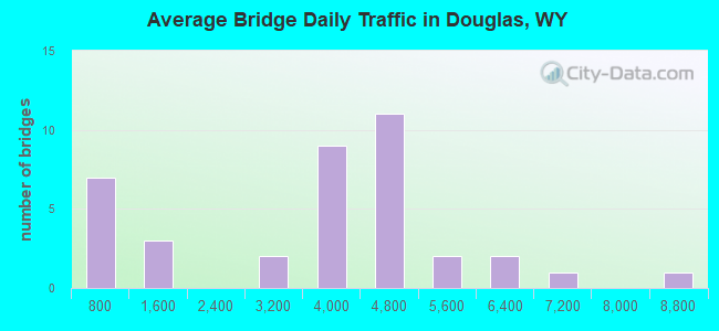
- 133,453Total average daily traffic
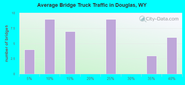
- 24,707Total average daily truck traffic
- National Bridge Inventory (NBI) Registered Bridges for Douglas
- No street view available for this location
- New bridges - historical statistics
- 11920-1929
- 11940-1949
- 11950-1959
- 281960-1969
- 11970-1979
- 41980-1989
- 11990-1999
- 12000-2009
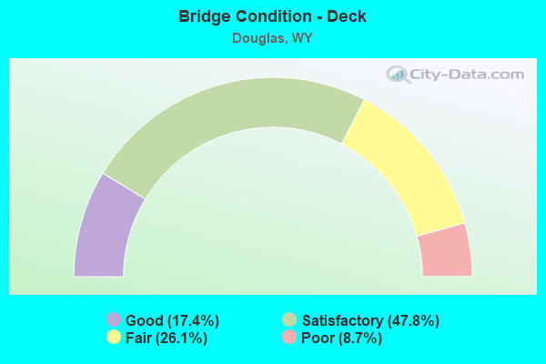
- Bridge Condition - Deck
- 17.4%Good
- 47.8%Satisfactory
- 26.1%Fair
- 8.7%Poor
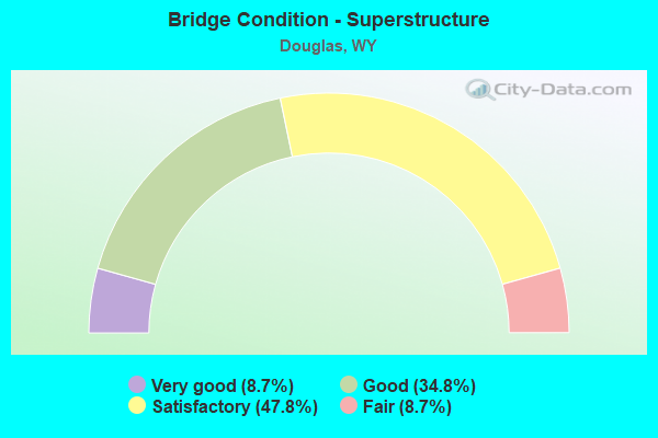
- Bridge Condition - Superstructure
- 8.7%Very good
- 34.8%Good
- 47.8%Satisfactory
- 8.7%Fair
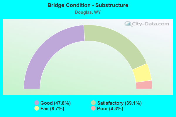
- Bridge Condition - Substructure
- 47.8%Good
- 39.1%Satisfactory
- 8.7%Fair
- 4.3%Poor
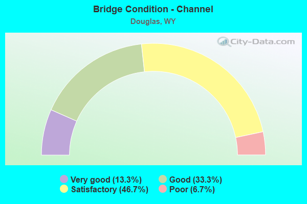
- Bridge Condition - Channel
- 13.3%Very good
- 33.3%Good
- 46.7%Satisfactory
- 6.7%Poor
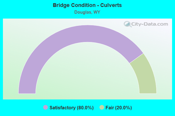
- Bridge Condition - Culverts
- 80.0%Satisfactory
- 20.0%Fair
Find on map >> Show street view
Structure Number: AFQ, Location: Orin Junction - Douglas (Lat: 42.732167, Lng: -105.341261), Route carried "on" structure: Interstate 25, Year Built: 1967, Status: Open, Structure Length: 4.91m (16.11ft), Average Daily Traffic: 4,494 (year 2021), Truck Traffic: 20%, Average Future Daily Traffic: 6,292 (year 2041), Design Load: HS 20+Mod, Features Intersected: South Douglas Intg
Minimum Vertical Clearance: 30+ m (98+ ft), Kilometerpoint: 217.595, Lanes on structure: 2, Lanes under structure: 2, Base Highway Network: Yes (Inventory Route: ML2, Subroute: 1), Owner: State Highway Agency, Approaching Roadway Width: 11.3m (37.1ft), Skew: 14 degrees, Material/Design: Concrete continuous, Design/Construction: Tee Beam, Number Of Spans In Main Unit: 3, Length of Maximum Span: 20.7m (67.9ft), Curb-To-Curb Width: 11.6m (38.1ft), Out-to-Out Width: 12.4m (40.7ft)
Condition: Deck: Satisfactory, Superstructure: Good, Substructure: Satisfactory, Operating Rating: 47.2 metric tons, Method Used To Determine Operating Rating: Load Factor (LF), Inventory Rating: 28.1 metric tons, Method Used To Determine Inventory Rating: Load Factor (LF), Structural Evaluation: Equal to present minimum criteria, Deck Geometry: Equal to present minimum criteria, Underclear: High priority of corrective action, Approach Roadway Alignment: Equal to present desirable criteria, Designated Inspection Frequency: Every 24 months, Inspection Date: April 2020, Deck Structure Type: Concrete Cast-file-Place, Wearing Surface/Protective System: Wearing Surface: Latex Concrete
Find on map >> Show street view
Structure Number: AFR, Location: Orin Junction - Douglas (Lat: 42.731936, Lng: -105.341214), Route carried "on" structure: Interstate 25, Year Built: 1967, Status: Open, Structure Length: 4.91m (16.11ft), Average Daily Traffic: 4,530 (year 2021), Truck Traffic: 20%, Average Future Daily Traffic: 6,342 (year 2041), Design Load: HS 20+Mod, Features Intersected: South Douglas Intg
Minimum Vertical Clearance: 30+ m (98+ ft), Kilometerpoint: 217.606, Lanes on structure: 2, Lanes under structure: 2, Base Highway Network: Yes, Owner: State Highway Agency, Approaching Roadway Width: 11.3m (37.1ft), Skew: 14 degrees, Material/Design: Concrete continuous, Design/Construction: Tee Beam, Number Of Spans In Main Unit: 3, Length of Maximum Span: 20.7m (67.9ft), Curb-To-Curb Width: 11.6m (38.1ft), Out-to-Out Width: 12.4m (40.7ft)
Condition: Deck: Satisfactory, Superstructure: Good, Substructure: Good, Operating Rating: 47.2 metric tons, Method Used To Determine Operating Rating: Load Factor (LF), Inventory Rating: 28.1 metric tons, Method Used To Determine Inventory Rating: Load Factor (LF), Structural Evaluation: Better than present minimum criteria, Deck Geometry: Equal to present minimum criteria, Underclear: Meets minimum limits, Approach Roadway Alignment: Equal to present desirable criteria, Designated Inspection Frequency: Every 24 months, Inspection Date: April 2020, Deck Structure Type: Concrete Cast-file-Place, Wearing Surface/Protective System: Wearing Surface: Latex Concrete
Find on map >> Show street view
Structure Number: AFT, Location: Orin Junction - Casper (Lat: 42.737861, Lng: -105.377219), Route carried "on" structure: Interstate 25, Year Built: 1967, Status: Open, Structure Length: 2.80m (9.19ft), Average Daily Traffic: 3,763 (year 2021), Truck Traffic: 37%, Average Future Daily Traffic: 5,268 (year 2041), Design Load: HS 20+Mod, Features Intersected: Golf Course Road
Minimum Vertical Clearance: 30+ m (98+ ft), Kilometerpoint: 220.717, Lanes on structure: 2, Lanes under structure: 2, Base Highway Network: Yes, Owner: State Highway Agency, Approaching Roadway Width: 11.6m (38.1ft), Skew: 10 degrees, Material/Design: Concrete continuous, Design/Construction: Tee Beam, Number Of Spans In Main Unit: 3, Length of Maximum Span: 11.3m (37.1ft), Curb-To-Curb Width: 11.6m (38.1ft), Out-to-Out Width: 12.4m (40.7ft)
Condition: Deck: Fair, Superstructure: Satisfactory, Substructure: Good, Operating Rating: 49.0 metric tons, Method Used To Determine Operating Rating: Load Factor (LF), Inventory Rating: 29.0 metric tons, Method Used To Determine Inventory Rating: Load Factor (LF), Structural Evaluation: Equal to present minimum criteria, Deck Geometry: Equal to present minimum criteria, Underclear: Meets minimum limits, Approach Roadway Alignment: Equal to present desirable criteria, Designated Inspection Frequency: Every 24 months, Inspection Date: April 2020, Deck Structure Type: Concrete Cast-file-Place, Wearing Surface/Protective System: Wearing Surface: Latex Concrete
Find on map >> Show street view
Structure Number: AFU, Location: Orin Junction - Casper (Lat: 42.737683, Lng: -105.377197), Route carried "on" structure: Interstate 25, Year Built: 1967, Status: Open, Structure Length: 2.80m (9.19ft), Average Daily Traffic: 4,258 (year 2021), Truck Traffic: 20%, Average Future Daily Traffic: 5,961 (year 2041), Design Load: HS 20+Mod, Features Intersected: Golf Course Road
Minimum Vertical Clearance: 30+ m (98+ ft), Kilometerpoint: 220.730, Lanes on structure: 2, Lanes under structure: 2, Base Highway Network: Yes, Owner: State Highway Agency, Approaching Roadway Width: 11.6m (38.1ft), Skew: 10 degrees, Material/Design: Concrete continuous, Design/Construction: Tee Beam, Number Of Spans In Main Unit: 3, Length of Maximum Span: 11.3m (37.1ft), Curb-To-Curb Width: 11.6m (38.1ft), Out-to-Out Width: 12.4m (40.7ft)
Condition: Deck: Poor, Superstructure: Satisfactory, Substructure: Good, Operating Rating: 49.0 metric tons, Method Used To Determine Operating Rating: Load Factor (LF), Inventory Rating: 29.0 metric tons, Method Used To Determine Inventory Rating: Load Factor (LF), Structural Evaluation: Equal to present minimum criteria, Deck Geometry: Equal to present minimum criteria, Underclear: Meets minimum limits, Approach Roadway Alignment: Equal to present desirable criteria, Designated Inspection Frequency: Every 24 months, Inspection Date: April 2020, Deck Structure Type: Concrete Cast-file-Place, Wearing Surface/Protective System: Wearing Surface: Latex Concrete
Find on map >> Show street view
Structure Number: AFV, Location: Orin Junction - Casper (Lat: 42.737672, Lng: -105.380097), Route carried "on" structure: Interstate 25, Year Built: 1967, Status: Open, Structure Length: 3.66m (12.01ft), Average Daily Traffic: 3,763 (year 2021), Truck Traffic: 37%, Average Future Daily Traffic: 5,268 (year 2041), Design Load: HS 20+Mod, Features Intersected: BNSF Railway
Minimum Vertical Clearance: 30+ m (98+ ft), Kilometerpoint: 220.953, Lanes on structure: 2, Base Highway Network: Yes, Owner: State Highway Agency, Approaching Roadway Width: 11.6m (38.1ft), Skew: 10 degrees, Material/Design: Steel continuous, Design/Construction: Stringer/Multi-beam, Number Of Spans In Main Unit: 3, Length of Maximum Span: 14.0m (45.9ft), Curb-To-Curb Width: 11.6m (38.1ft), Out-to-Out Width: 12.4m (40.7ft)
Condition: Deck: Satisfactory, Superstructure: Good, Substructure: Good, Operating Rating: 49.0 metric tons, Method Used To Determine Operating Rating: Load Factor (LF), Inventory Rating: 29.0 metric tons, Method Used To Determine Inventory Rating: Load Factor (LF), Structural Evaluation: Better than present minimum criteria, Deck Geometry: Equal to present minimum criteria, Underclear: Better than present minimum criteria, Approach Roadway Alignment: Equal to present desirable criteria, Designated Inspection Frequency: Every 24 months, Inspection Date: April 2021, Deck Structure Type: Concrete Cast-file-Place, Wearing Surface/Protective System: Wearing Surface: Latex Concrete
Find on map >> Show street view
Structure Number: AFW, Location: Orin Junction - Casper (Lat: 42.737500, Lng: -105.380047), Route carried "on" structure: Interstate 25, Year Built: 1967, Status: Open, Structure Length: 3.66m (12.01ft), Average Daily Traffic: 4,258 (year 2021), Truck Traffic: 20%, Average Future Daily Traffic: 5,961 (year 2041), Design Load: HS 20+Mod, Features Intersected: BNSF Railway
Minimum Vertical Clearance: 30+ m (98+ ft), Kilometerpoint: 220.965, Lanes on structure: 2, Base Highway Network: Yes, Owner: State Highway Agency, Approaching Roadway Width: 11.6m (38.1ft), Skew: 10 degrees, Material/Design: Steel continuous, Design/Construction: Stringer/Multi-beam, Number Of Spans In Main Unit: 3, Length of Maximum Span: 14.0m (45.9ft), Curb-To-Curb Width: 11.6m (38.1ft), Out-to-Out Width: 12.4m (40.7ft)
Condition: Deck: Satisfactory, Superstructure: Good, Substructure: Satisfactory, Operating Rating: 50.6 metric tons, Method Used To Determine Operating Rating: Load Factor (LF), Inventory Rating: 30.4 metric tons, Method Used To Determine Inventory Rating: Load Factor (LF), Structural Evaluation: Equal to present minimum criteria, Deck Geometry: Equal to present minimum criteria, Underclear: Better than present minimum criteria, Approach Roadway Alignment: Equal to present desirable criteria, Designated Inspection Frequency: Every 24 months, Inspection Date: April 2021, Deck Structure Type: Concrete Cast-file-Place, Wearing Surface/Protective System: Wearing Surface: Latex Concrete
Find on map >> Show street view
Structure Number: AFX, Location: Orin Junction - Casper (Lat: 42.737617, Lng: -105.380958), Route carried "on" structure: Interstate 25, Year Built: 1967, Status: Open, Structure Length: 5.47m (17.95ft), Average Daily Traffic: 3,763 (year 2021), Truck Traffic: 37%, Average Future Daily Traffic: 5,268 (year 2041), Design Load: HS 20+Mod, Features Intersected: Co CR 1 / Irvine Road
Minimum Vertical Clearance: 30+ m (98+ ft), Kilometerpoint: 221.024, Lanes on structure: 2, Lanes under structure: 2, Base Highway Network: Yes, Owner: State Highway Agency, Approaching Roadway Width: 11.6m (38.1ft), Skew: 10 degrees, Material/Design: Steel continuous, Design/Construction: Stringer/Multi-beam, Number Of Spans In Main Unit: 4, Length of Maximum Span: 15.7m (51.5ft), Curb-To-Curb Width: 11.6m (38.1ft), Out-to-Out Width: 12.4m (40.7ft)
Condition: Deck: Good, Superstructure: Good, Substructure: Satisfactory, Operating Rating: 56.2 metric tons, Method Used To Determine Operating Rating: Load Factor (LF), Inventory Rating: 33.6 metric tons, Method Used To Determine Inventory Rating: Load Factor (LF), Structural Evaluation: Equal to present minimum criteria, Deck Geometry: Equal to present minimum criteria, Underclear: Equal to present minimum criteria, Approach Roadway Alignment: Equal to present desirable criteria, Designated Inspection Frequency: Every 24 months, Inspection Date: April 2021, Deck Structure Type: Concrete Cast-file-Place, Wearing Surface/Protective System: Wearing Surface: Latex Concrete
Find on map >> Show street view
Structure Number: AFY, Location: Orin Junction - Casper (Lat: 42.737442, Lng: -105.380906), Route carried "on" structure: Interstate 25, Year Built: 1967, Status: Open, Structure Length: 5.47m (17.95ft), Average Daily Traffic: 4,258 (year 2021), Truck Traffic: 20%, Average Future Daily Traffic: 5,961 (year 2041), Design Load: HS 20+Mod, Features Intersected: Co CR 1 / Irvine Road
Minimum Vertical Clearance: 30+ m (98+ ft), Kilometerpoint: 221.035, Lanes on structure: 2, Lanes under structure: 2, Base Highway Network: Yes, Owner: State Highway Agency, Approaching Roadway Width: 11.6m (38.1ft), Skew: 10 degrees, Material/Design: Steel continuous, Design/Construction: Stringer/Multi-beam, Number Of Spans In Main Unit: 4, Length of Maximum Span: 15.7m (51.5ft), Curb-To-Curb Width: 11.6m (38.1ft), Out-to-Out Width: 12.4m (40.7ft)
Condition: Deck: Satisfactory, Superstructure: Fair, Substructure: Fair, Operating Rating: 56.2 metric tons, Method Used To Determine Operating Rating: Load Factor (LF), Inventory Rating: 33.6 metric tons, Method Used To Determine Inventory Rating: Load Factor (LF), Structural Evaluation: Somewhat better than minimum adequacy, Deck Geometry: Equal to present minimum criteria, Underclear: Better than present minimum criteria, Approach Roadway Alignment: Equal to present desirable criteria, Designated Inspection Frequency: Every 24 months, Inspection Date: April 2021, Deck Structure Type: Concrete Cast-file-Place, Wearing Surface/Protective System: Wearing Surface: Latex Concrete
Find on map >> Show street view
Structure Number: AFZ, Location: Orin Junction - Casper (Lat: 42.741569, Lng: -105.399356), Route carried "on" structure: Interstate 25, Year Built: 1966, Status: Open, Structure Length: 14.14m (46.39ft), Average Daily Traffic: 3,763 (year 2021), Truck Traffic: 37%, Average Future Daily Traffic: 5,268 (year 2041), Design Load: HS 20+Mod, Features Intersected: North Platte River
Minimum Vertical Clearance: 30+ m (98+ ft), Kilometerpoint: 222.658, Lanes on structure: 2, Base Highway Network: Yes, Owner: State Highway Agency, Approaching Roadway Width: 11.3m (37.1ft), Skew: 11 degrees, Material/Design: Steel continuous, Design/Construction: Stringer/Multi-beam, Number Of Spans In Main Unit: 4, Length of Maximum Span: 39.6m (129.9ft), Curb-To-Curb Width: 9.8m (32.2ft), Out-to-Out Width: 10.6m (34.8ft)
Condition: Deck: Fair, Superstructure: Satisfactory, Substructure: Good, Channel: Very good, Operating Rating: 51.7 metric tons, Method Used To Determine Operating Rating: Load Factor (LF), Inventory Rating: 30.8 metric tons, Method Used To Determine Inventory Rating: Load Factor (LF), Structural Evaluation: Equal to present minimum criteria, Deck Geometry: Meets minimum limits, Waterway Adequacy: Equal to present desirable criteria, Approach Roadway Alignment: Equal to present desirable criteria, Length Of Structure Improvement: 2.44m (8.01ft), Designated Inspection Frequency: Every 24 months, Underwater Inspection Frequency: Every 60 months, Inspection Date: April 2021, Underwater Inspection Date: October 2019, Bridge Improvement Cost: $20,000, Roadway Improvement Cost: $1,000, Total Project Cost: $25,000, Deck Structure Type: Concrete Cast-file-Place, Wearing Surface/Protective System: Wearing Surface: Latex Concrete
Find on map >> Show street view
Structure Number: AGA, Location: Orin Junction - Casper (Lat: 42.741400, Lng: -105.399450), Route carried "on" structure: Interstate 25, Year Built: 1966, Status: Open, Structure Length: 14.14m (46.39ft), Average Daily Traffic: 4,258 (year 2021), Truck Traffic: 20%, Average Future Daily Traffic: 5,961 (year 2041), Design Load: HS 20+Mod, Features Intersected: North Platte River
Minimum Vertical Clearance: 30+ m (98+ ft), Kilometerpoint: 222.683, Lanes on structure: 2, Base Highway Network: Yes, Owner: State Highway Agency, Approaching Roadway Width: 11.3m (37.1ft), Skew: 11 degrees, Material/Design: Steel continuous, Design/Construction: Stringer/Multi-beam, Number Of Spans In Main Unit: 4, Length of Maximum Span: 39.6m (129.9ft), Curb-To-Curb Width: 9.8m (32.2ft), Out-to-Out Width: 10.6m (34.8ft)
Condition: Deck: Fair, Superstructure: Satisfactory, Substructure: Good, Channel: Very good, Operating Rating: 51.7 metric tons, Method Used To Determine Operating Rating: Load Factor (LF), Inventory Rating: 30.8 metric tons, Method Used To Determine Inventory Rating: Load Factor (LF), Structural Evaluation: Equal to present minimum criteria, Deck Geometry: Meets minimum limits, Waterway Adequacy: Equal to present desirable criteria, Approach Roadway Alignment: Equal to present desirable criteria, Designated Inspection Frequency: Every 24 months, Underwater Inspection Frequency: Every 60 months, Inspection Date: April 2021, Underwater Inspection Date: October 2019, Deck Structure Type: Concrete Cast-file-Place, Wearing Surface/Protective System: Wearing Surface: Latex Concrete
Find on map >> Show street view
Structure Number: AGB, Location: Orin Junction - Casper (Lat: 42.755725, Lng: -105.407925), Route carried "on" structure: Interstate 25, Year Built: 1966, Status: Open, Structure Length: 4.27m (14.01ft), Average Daily Traffic: 3,763 (year 2021), Truck Traffic: 37%, Average Future Daily Traffic: 5,268 (year 2041), Design Load: HS 20+Mod, Features Intersected: WYO 94 / Esterbrook Rd
Minimum Vertical Clearance: 30+ m (98+ ft), Kilometerpoint: 224.483, Lanes on structure: 2, Lanes under structure: 2, Base Highway Network: Yes, Owner: State Highway Agency, Approaching Roadway Width: 11.6m (38.1ft), Skew: 13 degrees, Material/Design: Concrete continuous, Design/Construction: Box Beam or Girders - Multiple, Number Of Spans In Main Unit: 3, Length of Maximum Span: 16.5m (54.1ft), Curb-To-Curb Width: 11.6m (38.1ft), Out-to-Out Width: 12.4m (40.7ft)
Condition: Deck: Satisfactory, Superstructure: Satisfactory, Substructure: Satisfactory, Operating Rating: 59.9 metric tons, Method Used To Determine Operating Rating: Load Factor (LF), Inventory Rating: 35.4 metric tons, Method Used To Determine Inventory Rating: Load Factor (LF), Structural Evaluation: Equal to present minimum criteria, Deck Geometry: Equal to present minimum criteria, Underclear: Meets minimum limits, Approach Roadway Alignment: Equal to present desirable criteria, Designated Inspection Frequency: Every 24 months, Inspection Date: April 2021, Deck Structure Type: Concrete Cast-file-Place, Wearing Surface/Protective System: Wearing Surface: Latex Concrete
Find on map >> Show street view
Structure Number: AGC, Location: Orin Junction - Casper (Lat: 42.755556, Lng: -105.408086), Route carried "on" structure: Interstate 25, Year Built: 1966, Status: Open, Structure Length: 4.27m (14.01ft), Average Daily Traffic: 4,258 (year 2021), Truck Traffic: 20%, Average Future Daily Traffic: 5,961 (year 2041), Design Load: HS 20+Mod, Features Intersected: WYO 94 / Esterbrook Rd
Minimum Vertical Clearance: 30+ m (98+ ft), Kilometerpoint: 224.513, Lanes on structure: 2, Lanes under structure: 2, Base Highway Network: Yes, Owner: State Highway Agency, Approaching Roadway Width: 11.6m (38.1ft), Skew: 13 degrees, Material/Design: Concrete continuous, Design/Construction: Box Beam or Girders - Multiple, Number Of Spans In Main Unit: 3, Length of Maximum Span: 16.5m (54.1ft), Curb-To-Curb Width: 11.6m (38.1ft), Out-to-Out Width: 12.4m (40.7ft)
Condition: Deck: Satisfactory, Superstructure: Satisfactory, Substructure: Satisfactory, Operating Rating: 59.9 metric tons, Method Used To Determine Operating Rating: Load Factor (LF), Inventory Rating: 35.4 metric tons, Method Used To Determine Inventory Rating: Load Factor (LF), Structural Evaluation: Equal to present minimum criteria, Deck Geometry: Equal to present minimum criteria, Underclear: Meets minimum limits, Approach Roadway Alignment: Equal to present desirable criteria, Length Of Structure Improvement: 0.30m (0.98ft), Designated Inspection Frequency: Every 24 months, Inspection Date: April 2021, Bridge Improvement Cost: $1,000, Roadway Improvement Cost: $1,000, Total Project Cost: $3,000, Deck Structure Type: Concrete Cast-file-Place, Wearing Surface/Protective System: Wearing Surface: Latex Concrete
Find on map >> Show street view
Structure Number: AGD, Location: Douglas - Casper (Lat: 42.771100, Lng: -105.434194), Route carried "on" structure: Interstate 25, Year Built: 1961, Status: Open, Structure Length: 1.02m (3.35ft), Average Daily Traffic: 4,624 (year 2021), Truck Traffic: 31%, Average Future Daily Traffic: 6,474 (year 2041), Features Intersected: Six Mile Creek
Minimum Vertical Clearance: 30+ m (98+ ft), Kilometerpoint: 227.399, Lanes on structure: 4, Base Highway Network: Yes, Owner: State Highway Agency, Approaching Roadway Width: 25.9m (85.0ft), Material/Design: Concrete continuous, Design/Construction: Culvert, Number Of Spans In Main Unit: 3, Length of Maximum Span: 3.6m (11.8ft)
Condition: Channel: Satisfactory, Culverts: Fair, Operating Rating: 32.7 metric tons, Method Used To Determine Operating Rating: Field evaluation and documented engineering judgment, Inventory Rating: 32.7 metric tons, Method Used To Determine Inventory Rating: Field evaluation and documented engineering judgment, Structural Evaluation: Somewhat better than minimum adequacy, Waterway Adequacy: Equal to present desirable criteria, Approach Roadway Alignment: Equal to present desirable criteria, Designated Inspection Frequency: Every 24 months, Inspection Date: April 2021
Find on map >> Show street view
Structure Number: AGF, Location: Douglas - Casper (Lat: 42.780689, Lng: -105.462803), Route carried "on" structure: Interstate 25, Year Built: 1961, Status: Open, Structure Length: 1.00m (3.28ft), Average Daily Traffic: 4,624 (year 2021), Truck Traffic: 31%, Average Future Daily Traffic: 6,474 (year 2041), Features Intersected: Five Mile Creek
Minimum Vertical Clearance: 30+ m (98+ ft), Kilometerpoint: 230.236, Lanes on structure: 2, Base Highway Network: Yes, Owner: State Highway Agency, Approaching Roadway Width: 14.0m (45.9ft), Skew: 10 degrees, Material/Design: Concrete continuous, Design/Construction: Culvert, Number Of Spans In Main Unit: 3, Length of Maximum Span: 3.6m (11.8ft)
Condition: Channel: Satisfactory, Culverts: Satisfactory, Operating Rating: 32.7 metric tons, Method Used To Determine Operating Rating: Field evaluation and documented engineering judgment, Inventory Rating: 32.7 metric tons, Method Used To Determine Inventory Rating: Field evaluation and documented engineering judgment, Structural Evaluation: Equal to present minimum criteria, Waterway Adequacy: Equal to present desirable criteria, Approach Roadway Alignment: Equal to present desirable criteria, Designated Inspection Frequency: Every 24 months, Inspection Date: April 2021
Find on map >> Show street view
Structure Number: AGG, Location: Douglas - Casper (Lat: 42.780275, Lng: -105.462797), Route carried "on" structure: Interstate 25, Year Built: 1961, Status: Open, Structure Length: 1.00m (3.28ft), Average Daily Traffic: 4,577 (year 2021), Truck Traffic: 20%, Average Future Daily Traffic: 6,408 (year 2041), Features Intersected: Five Mile Creek
Minimum Vertical Clearance: 30+ m (98+ ft), Kilometerpoint: 230.238, Lanes on structure: 2, Base Highway Network: Yes, Owner: State Highway Agency, Approaching Roadway Width: 13.0m (42.7ft), Skew: 10 degrees, Material/Design: Concrete continuous, Design/Construction: Culvert, Number Of Spans In Main Unit: 3, Length of Maximum Span: 3.6m (11.8ft)
Condition: Channel: Satisfactory, Culverts: Satisfactory, Operating Rating: 32.7 metric tons, Method Used To Determine Operating Rating: Field evaluation and documented engineering judgment, Inventory Rating: 32.7 metric tons, Method Used To Determine Inventory Rating: Field evaluation and documented engineering judgment, Structural Evaluation: Equal to present minimum criteria, Waterway Adequacy: Equal to present desirable criteria, Approach Roadway Alignment: Equal to present desirable criteria, Designated Inspection Frequency: Every 24 months, Inspection Date: April 2021
Find on map >> Show street view
Structure Number: BLM, Location: Douglas (Lat: 42.759475, Lng: -105.412228), Route carried "on" structure: Business US 58, Year Built: 1966, Status: Open, Structure Length: 7.47m (24.51ft), Average Daily Traffic: 5,972 (year 2021), Truck Traffic: 8%, Average Future Daily Traffic: 8,361 (year 2041), Design Load: HS 20, Features Intersected: I-25, Facility Carried by Structure: I25/US20-26-87 Bus
Minimum Vertical Clearance: 30+ m (98+ ft), Kilometerpoint: 226.050, Lanes on structure: 2, Lanes under structure: 4, Base Highway Network: Yes, Owner: State Highway Agency, Approaching Roadway Width: 12.8m (42.0ft), Skew: 23 degrees, Material/Design: Steel continuous, Design/Construction: Stringer/Multi-beam, Number Of Spans In Main Unit: 4, Length of Maximum Span: 21.9m (71.9ft), Curb-To-Curb Width: 11.6m (38.1ft), Out-to-Out Width: 13.6m (44.6ft)
Condition: Deck: Satisfactory, Superstructure: Satisfactory, Substructure: Good, Operating Rating: 67.1 metric tons, Method Used To Determine Operating Rating: Load Factor (LF), Inventory Rating: 39.9 metric tons, Method Used To Determine Inventory Rating: Load Factor (LF), Structural Evaluation: Equal to present minimum criteria, Deck Geometry: Somewhat better than minimum adequacy, Underclear: High priority of corrective action, Approach Roadway Alignment: Equal to present desirable criteria, Length Of Structure Improvement: 1.52m (4.99ft), Designated Inspection Frequency: Every 24 months, Inspection Date: April 2021, Bridge Improvement Cost: $25,000, Roadway Improvement Cost: $3,000, Total Project Cost: $38,000, Deck Structure Type: Concrete Cast-file-Place, Wearing Surface/Protective System: Wearing Surface: Latex Concrete
Find on map >> Show street view
Structure Number: CFQ, Location: Douglas (Lat: 42.765619, Lng: -105.382681), Route carried "on" structure: City street 4827, Year Built: 1967, Status: Open, Structure Length: 2.38m (7.81ft), Average Daily Traffic: 3,698 (year 2021), Truck Traffic: 5%, Average Future Daily Traffic: 5,177 (year 2041), Design Load: HS 20, Features Intersected: E Fork Antelope Creek, Facility Carried by Structure: N. 4th Street
Minimum Vertical Clearance: 30+ m (98+ ft), Kilometerpoint: 1.775, Lanes on structure: 2, Owner: Town or Township Highway Agency, Approaching Roadway Width: 12.8m (42.0ft), Skew: 4 degrees, Material/Design: Concrete continuous, Design/Construction: Slab, Number Of Spans In Main Unit: 3, Length of Maximum Span: 9.1m (29.9ft), Curb or Sidewalk Widths: Left: 1.5m (4.9ft), Right: 1.5m (4.9ft), Curb-To-Curb Width: 14.0m (45.9ft), Out-to-Out Width: 18.0m (59.1ft)
Condition: Deck: Good, Superstructure: Good, Substructure: Good, Channel: Poor, Operating Rating: 52.3 metric tons, Method Used To Determine Operating Rating: Load Factor (LF), Inventory Rating: 31.4 metric tons, Method Used To Determine Inventory Rating: Load Factor (LF), Structural Evaluation: Better than present minimum criteria, Deck Geometry: Superior to present desirable criteria, Waterway Adequacy: Equal to present desirable criteria, Approach Roadway Alignment: Equal to present desirable criteria, Designated Inspection Frequency: Every 24 months, Inspection Date: September 2020, Deck Structure Type: Concrete Cast-file-Place, Wearing Surface/Protective System: Wearing Surface: Bituminous
Find on map >> Show street view
Structure Number: CFR, Location: Douglas (Lat: 42.769169, Lng: -105.382619), Route carried "on" structure: City street 4827, Year Built: 1972, Status: Open, Structure Length: 4.27m (14.01ft), Average Daily Traffic: 3,561 (year 2021), Truck Traffic: 5%, Average Future Daily Traffic: 4,985 (year 2041), Design Load: HS 20, Features Intersected: Antelope Creek, Facility Carried by Structure: N. 4th Street
Minimum Vertical Clearance: 30+ m (98+ ft), Kilometerpoint: 1.381, Lanes on structure: 2, Owner: Town or Township Highway Agency, Approaching Roadway Width: 9.8m (32.2ft), Skew: 4 degrees, Material/Design: Steel, Design/Construction: Stringer/Multi-beam, Number Of Spans In Main Unit: 3, Length of Maximum Span: 16.5m (54.1ft), Curb-To-Curb Width: 9.8m (32.2ft), Out-to-Out Width: 10.6m (34.8ft)
Condition: Deck: Satisfactory, Superstructure: Very good, Substructure: Satisfactory, Channel: Good, Operating Rating: 50.8 metric tons, Method Used To Determine Operating Rating: Allowable Stress (AS), Inventory Rating: 34.5 metric tons, Method Used To Determine Inventory Rating: Allowable Stress (AS), Structural Evaluation: Equal to present minimum criteria, Deck Geometry: Meets minimum limits, Waterway Adequacy: Equal to present desirable criteria, Approach Roadway Alignment: Equal to present desirable criteria, Length Of Structure Improvement: 4.27m (14.01ft), Designated Inspection Frequency: Every 24 months, Inspection Date: September 2020, Bridge Improvement Cost: $3,000, Roadway Improvement Cost: $1,000, Total Project Cost: $5,000 ( Estimate for 2014), Deck Structure Type: Concrete Cast-file-Place, Wearing Surface/Protective System: Wearing Surface: Bituminous
Find on map >> Show street view
Structure Number: CMZ, Location: Douglas - North (Lat: 42.771308, Lng: -105.433617), Route carried "on" structure: State highway 93, Year Built: 1961, Status: Open, Structure Length: 0.97m (3.18ft), Average Daily Traffic: 5,417 (year 2021), Truck Traffic: 3%, Average Future Daily Traffic: 7,584 (year 2041), Design Load: HS 20, Features Intersected: Six Mile Creek
Minimum Vertical Clearance: 30+ m (98+ ft), Kilometerpoint: 2.696, Lanes on structure: 2, Owner: State Highway Agency, Approaching Roadway Width: 9.4m (30.8ft), Material/Design: Concrete continuous, Design/Construction: Culvert, Number Of Spans In Main Unit: 3, Length of Maximum Span: 3.6m (11.8ft)
Condition: Channel: Satisfactory, Culverts: Satisfactory, Operating Rating: 32.7 metric tons, Method Used To Determine Operating Rating: Field evaluation and documented engineering judgment, Inventory Rating: 32.7 metric tons, Method Used To Determine Inventory Rating: Field evaluation and documented engineering judgment, Structural Evaluation: Equal to present minimum criteria, Waterway Adequacy: Equal to present desirable criteria, Approach Roadway Alignment: Equal to present desirable criteria, Designated Inspection Frequency: Every 24 months, Inspection Date: April 2021
Find on map >> Show street view
Structure Number: CNC, Location: Douglas - South (Lat: 42.705158, Lng: -105.396925), Route carried "on" structure: State highway 94, Year Built: 1959, Status: Open, Structure Length: 2.45m (8.04ft), Average Daily Traffic: 763 (year 2021), Truck Traffic: 10%, Average Future Daily Traffic: 1,068 (year 2041), Design Load: HS 20, Features Intersected: Bed Tick Creek
Minimum Vertical Clearance: 30+ m (98+ ft), Kilometerpoint: 6.568, Lanes on structure: 2, Owner: State Highway Agency, Approaching Roadway Width: 8.5m (27.9ft), Material/Design: Concrete continuous, Design/Construction: Slab, Number Of Spans In Main Unit: 3, Length of Maximum Span: 9.1m (29.9ft), Curb-To-Curb Width: 8.5m (27.9ft), Out-to-Out Width: 9.5m (31.2ft)
Condition: Deck: Good, Superstructure: Good, Substructure: Satisfactory, Channel: Satisfactory, Operating Rating: 44.1 metric tons, Method Used To Determine Operating Rating: Load Factor (LF), Inventory Rating: 26.5 metric tons, Method Used To Determine Inventory Rating: Load Factor (LF), Structural Evaluation: Equal to present minimum criteria, Deck Geometry: Somewhat better than minimum adequacy, Waterway Adequacy: Equal to present desirable criteria, Approach Roadway Alignment: Equal to present desirable criteria, Designated Inspection Frequency: Every 24 months, Inspection Date: January 2021, Deck Structure Type: Concrete Cast-file-Place, Wearing Surface/Protective System: Wearing Surface: Bituminous, Membrane: Preformed Fabric
Find on map >> Show street view
Structure Number: CND, Location: Douglas - South (Lat: 42.689222, Lng: -105.392075), Route carried "on" structure: State highway 94, Year Built: 1961, Status: Open, Structure Length: 0.89m (2.92ft), Average Daily Traffic: 763 (year 2021), Truck Traffic: 10%, Average Future Daily Traffic: 1,068 (year 2041), Design Load: HS 20, Features Intersected: Esmay Draw
Minimum Vertical Clearance: 30+ m (98+ ft), Kilometerpoint: 8.414, Lanes on structure: 2, Owner: State Highway Agency, Approaching Roadway Width: 8.5m (27.9ft), Skew: 4 degrees, Material/Design: Concrete continuous, Design/Construction: Culvert, Number Of Spans In Main Unit: 2, Length of Maximum Span: 3.0m (9.8ft)
Condition: Channel: Good, Culverts: Satisfactory, Operating Rating: 32.7 metric tons, Method Used To Determine Operating Rating: Field evaluation and documented engineering judgment, Inventory Rating: 32.7 metric tons, Method Used To Determine Inventory Rating: Field evaluation and documented engineering judgment, Structural Evaluation: Equal to present minimum criteria, Waterway Adequacy: Equal to present desirable criteria, Approach Roadway Alignment: Equal to present desirable criteria, Designated Inspection Frequency: Every 24 months, Inspection Date: January 2021
Find on map >> Show street view
Structure Number: FCI, Location: T32N R071W S09 (Lat: 42.765528, Lng: -105.385389), Route carried "on" structure: City street 100-1, Year Built: 1985, Status: Open, Structure Length: 1.28m (4.20ft), Average Daily Traffic: 425 (year 2021), Truck Traffic: 5%, Average Future Daily Traffic: 595 (year 2041), Design Load: HS 20, Features Intersected: Antelope Creek, Facility Carried by Structure: N. 2nd Street
Minimum Vertical Clearance: 30+ m (98+ ft), Kilometerpoint: 161.601, Lanes on structure: 2, Owner: Town or Township Highway Agency, Approaching Roadway Width: 7.3m (24.0ft), Material/Design: Steel, Design/Construction: Stringer/Multi-beam, Number Of Spans In Main Unit: 2, Length of Maximum Span: 6.4m (21.0ft), Curb-To-Curb Width: 7.2m (23.6ft), Out-to-Out Width: 7.3m (24.0ft)
Condition: Deck: Poor, Superstructure: Satisfactory, Substructure: Fair, Channel: Good, Operating Rating: 96.2 metric tons, Method Used To Determine Operating Rating: Load Factor (LF), Inventory Rating: 57.2 metric tons, Method Used To Determine Inventory Rating: Load Factor (LF), Structural Evaluation: Somewhat better than minimum adequacy, Deck Geometry: Meets minimum limits, Waterway Adequacy: Equal to present desirable criteria, Approach Roadway Alignment: Better than present minimum criteria, Length Of Structure Improvement: 1.95m (6.40ft), Designated Inspection Frequency: Every 24 months, Inspection Date: September 2020, Bridge Improvement Cost: $184,000, Roadway Improvement Cost: $18,000, Total Project Cost: $276,000 ( Estimate for 2014), Deck Structure Type: Corrugated Steel, Wearing Surface/Protective System: Wearing Surface: Bituminous
Find on map >> Show street view
Structure Number: FDB, Location: Douglas Bypass (Lat: 42.771558, Lng: -105.406358), Route carried "on" structure: State highway 59, Year Built: 1988, Status: Open, Structure Length: 14.63m (48.00ft), Average Daily Traffic: 6,280 (year 2021), Truck Traffic: 33%, Average Future Daily Traffic: 8,792 (year 2041), Design Load: HS 25 or greater, Features Intersected: North Platte River
Minimum Vertical Clearance: 30+ m (98+ ft), Kilometerpoint: 1.065, Lanes on structure: 2, Base Highway Network: Yes, Owner: State Highway Agency, Approaching Roadway Width: 13.4m (44.0ft), Material/Design: Steel continuous, Design/Construction: Stringer/Multi-beam, Number Of Spans In Main Unit: 5, Length of Maximum Span: 31.1m (102.0ft), Curb-To-Curb Width: 13.4m (44.0ft), Out-to-Out Width: 14.3m (46.9ft)
Condition: Deck: Fair, Superstructure: Good, Substructure: Good, Channel: Satisfactory, Operating Rating: 69.9 metric tons, Method Used To Determine Operating Rating: Load Factor (LF), Inventory Rating: 41.7 metric tons, Method Used To Determine Inventory Rating: Load Factor (LF), Structural Evaluation: Better than present minimum criteria, Deck Geometry: Equal to present minimum criteria, Waterway Adequacy: Equal to present desirable criteria, Approach Roadway Alignment: Equal to present desirable criteria, Designated Inspection Frequency: Every 24 months, Underwater Inspection Frequency: Every 60 months, Inspection Date: March 2020, Underwater Inspection Date: October 2019, Deck Structure Type: Concrete Cast-file-Place, Wearing Surface/Protective System: Deck Protection: Epoxy Coated Reinforcing
Find on map >> Show street view
Structure Number: FDC, Location: Douglas Bypass (Lat: 42.776703, Lng: -105.401175), Route carried "on" structure: State highway 59, Year Built: 1988, Status: Open, Structure Length: 16.52m (54.20ft), Average Daily Traffic: 5,440 (year 2021), Truck Traffic: 6%, Average Future Daily Traffic: 7,616 (year 2041), Design Load: HS 20, Features Intersected: BNSF Railway
Minimum Vertical Clearance: 30+ m (98+ ft), Kilometerpoint: 1.780, Lanes on structure: 2, Base Highway Network: Yes, Owner: State Highway Agency, Approaching Roadway Width: 13.4m (44.0ft), Material/Design: Steel continuous, Design/Construction: Stringer/Multi-beam, Number Of Spans In Main Unit: 4, Length of Maximum Span: 43.9m (144.0ft), Curb-To-Curb Width: 13.4m (44.0ft), Out-to-Out Width: 14.3m (46.9ft)
Condition: Deck: Fair, Superstructure: Satisfactory, Substructure: Satisfactory, Operating Rating: 57.2 metric tons, Method Used To Determine Operating Rating: Load Factor (LF), Inventory Rating: 34.5 metric tons, Method Used To Determine Inventory Rating: Load Factor (LF), Structural Evaluation: Equal to present minimum criteria, Deck Geometry: Equal to present minimum criteria, Underclear: Better than present minimum criteria, Approach Roadway Alignment: Equal to present desirable criteria, Designated Inspection Frequency: Every 24 months, Inspection Date: January 2021, Deck Structure Type: Concrete Cast-file-Place, Wearing Surface/Protective System: Deck Protection: Epoxy Coated Reinforcing
Find on map >> Show street view
Structure Number: FEB, Location: Richards Street (Douglas) (Lat: 42.749142, Lng: -105.393347), Route carried "on" structure: City street 4802, Year Built: 1984, Status: Open, Structure Length: 13.59m (44.59ft), Average Daily Traffic: 3,592 (year 2021), Truck Traffic: 4%, Average Future Daily Traffic: 5,029 (year 2041), Design Load: HS 20, Features Intersected: North Platte River, Facility Carried by Structure: W. Richards Street
Minimum Vertical Clearance: 30+ m (98+ ft), Kilometerpoint: 160.265, Lanes on structure: 4, Owner: Town or Township Highway Agency, Approaching Roadway Width: 16.2m (53.1ft), Skew: 1 degrees, Material/Design: Steel continuous, Design/Construction: Stringer/Multi-beam, Number Of Spans In Main Unit: 4, Length of Maximum Span: 38.1m (125.0ft), Curb or Sidewalk Widths: Left: 0.0m, Right: 3.0m (9.8ft), Curb-To-Curb Width: 17.1m (56.1ft), Out-to-Out Width: 21.2m (69.6ft)
Condition: Deck: Fair, Superstructure: Satisfactory, Substructure: Poor, Channel: Satisfactory, Operating Rating: 70.2 metric tons, Method Used To Determine Operating Rating: Load Factor (LF), Inventory Rating: 42.1 metric tons, Method Used To Determine Inventory Rating: Load Factor (LF), Structural Evaluation: Meets minimum limits, Deck Geometry: Somewhat better than minimum adequacy, Waterway Adequacy: Equal to present desirable criteria, Approach Roadway Alignment: Equal to present desirable criteria, Length Of Structure Improvement: 13.59m (44.59ft), Designated Inspection Frequency: Every 24 months, Underwater Inspection Frequency: Every 60 months, Inspection Date: September 2020, Underwater Inspection Date: October 2019, Bridge Improvement Cost: $50,000, Roadway Improvement Cost: $5,000, Total Project Cost: $75,000, Deck Structure Type: Concrete Cast-file-Place
Find on map >> Show street view
Structure Number: FRI, Location: Approx 5 Mi Se Of Douglas (Lat: 42.687197, Lng: -105.345589), Route carried "on" structure: County highway 1A, Year Built: 1946, Status: Posted for load, Structure Length: 4.11m (13.48ft), Average Daily Traffic: 101 (year 2021), Truck Traffic: 5%, Average Future Daily Traffic: 141 (year 2041), Design Load: HS 20, Features Intersected: BNSF Railway
Minimum Vertical Clearance: 30+ m (98+ ft), Kilometerpoint: 153.031, Lanes on structure: 2, Owner: County Highway Agency, Approaching Roadway Width: 5.8m (19.0ft), Material/Design: Wood or Timber, Design/Construction: Stringer/Multi-beam, Number Of Spans In Main Unit: 9, Length of Maximum Span: 7.6m (24.9ft), Curb or Sidewalk Widths: Left: 0.2m (0.7ft), Right: 0.2m (0.7ft), Curb-To-Curb Width: 4.9m (16.1ft), Out-to-Out Width: 5.8m (19.0ft)
Condition: Deck: Satisfactory, Superstructure: Fair, Substructure: Satisfactory, Operating Rating: 31.8 metric tons, Method Used To Determine Operating Rating: Allowable Stress (AS), Inventory Rating: 22.7 metric tons, Method Used To Determine Inventory Rating: Allowable Stress (AS), Structural Evaluation: Somewhat better than minimum adequacy, Deck Geometry: High priority of replacement, Underclear: Somewhat better than minimum adequacy, Approach Roadway Alignment: Better than present minimum criteria, Bridge Posting: Required (Relationship of Operating Rating to Maximum Legal Load: 10.0 - 19.9% below), Length Of Structure Improvement: 5.03m (16.50ft), Designated Inspection Frequency: Every 12 months, Inspection Date: September 2021, Bridge Improvement Cost: $31,000, Roadway Improvement Cost: $30,000, Total Project Cost: $64,000, Deck Structure Type: Wood or Timber, Wearing Surface/Protective System: Wearing Surface: Wood or Timber
Find on map >> Show street view
Structure Number: KBI, Location: Anderson Dairy Road (Lat: 42.720314, Lng: -105.390547), Route carried "on" structure: County highway 2, Year Built: 1996, Status: Open, Structure Length: 11.89m (39.01ft), Average Daily Traffic: 651 (year 2021), Truck Traffic: 10%, Average Future Daily Traffic: 911 (year 2041), Design Load: HS 25 or greater, Features Intersected: North Platte River
Minimum Vertical Clearance: 30+ m (98+ ft), Kilometerpoint: 0.583, Lanes on structure: 2, Owner: County Highway Agency, Approaching Roadway Width: 7.3m (24.0ft), Material/Design: Steel continuous, Design/Construction: Stringer/Multi-beam, Number Of Spans In Main Unit: 5, Length of Maximum Span: 25.0m (82.0ft), Curb-To-Curb Width: 7.3m (24.0ft), Out-to-Out Width: 8.2m (26.9ft)
Condition: Deck: Satisfactory, Superstructure: Satisfactory, Substructure: Good, Channel: Good, Operating Rating: 70.2 metric tons, Method Used To Determine Operating Rating: Load Factor (LF), Inventory Rating: 41.4 metric tons, Method Used To Determine Inventory Rating: Load Factor (LF), Structural Evaluation: Equal to present minimum criteria, Deck Geometry: Meets minimum limits, Waterway Adequacy: Equal to present desirable criteria, Approach Roadway Alignment: Equal to present desirable criteria, Designated Inspection Frequency: Every 24 months, Inspection Date: September 2021, Deck Structure Type: Concrete Cast-file-Place
Find on map >> Show street view
Structure Number: MAC, Location: Douglas (Lat: 42.762633, Lng: -105.393911), Route carried "on" structure: State highway 58, Year Built: 2009, Status: Open, Structure Length: 13.11m (43.01ft), Average Daily Traffic: 8,746 (year 2021), Truck Traffic: 6%, Average Future Daily Traffic: 12,244 (year 2041), Design Load: HS 25 or greater, Features Intersected: North Platte River, Facility Carried by Structure: I25/US20-26-87 Bus
Minimum Vertical Clearance: 30+ m (98+ ft), Kilometerpoint: 224.441, Lanes on structure: 5, Base Highway Network: Yes, Owner: State Highway Agency, Approaching Roadway Width: 20.7m (67.9ft), Skew: 1 degrees, Material/Design: Steel continuous, Design/Construction: Stringer/Multi-beam, Number Of Spans In Main Unit: 3, Length of Maximum Span: 48.8m (160.1ft), Curb or Sidewalk Widths: Left: 1.4m (4.6ft), Right: 1.4m (4.6ft), Curb-To-Curb Width: 20.7m (67.9ft), Out-to-Out Width: 25.5m (83.7ft)
Condition: Deck: Good, Superstructure: Very good, Substructure: Good, Channel: Good, Operating Rating: 79.8 metric tons, Method Used To Determine Operating Rating: Load Factor (LF), Inventory Rating: 47.2 metric tons, Method Used To Determine Inventory Rating: Load Factor (LF), Structural Evaluation: Better than present minimum criteria, Deck Geometry: Somewhat better than minimum adequacy, Waterway Adequacy: Equal to present desirable criteria, Approach Roadway Alignment: Equal to present desirable criteria, Length Of Structure Improvement: 14.05m (46.10ft), Designated Inspection Frequency: Every 24 months, Underwater Inspection Frequency: Every 60 months, Inspection Date: January 2021, Underwater Inspection Date: October 2019, Bridge Improvement Cost: $3,847,000, Roadway Improvement Cost: $385,000, Total Project Cost: $5,770,000 ( Estimate for 2015), Deck Structure Type: Concrete Cast-file-Place, Wearing Surface/Protective System: Deck Protection: Epoxy Coated Reinforcing
Find on map >> Show street view
Structure Number: AFQ, Location: Orin Junction - Douglas (Lat: 42.732167, Lng: -105.341261), Route carried "under" structure: US 20, Year Built: 1967, Structure Length: 0. m, Average Daily Traffic: 6,762 (year 2021), Truck Traffic: 11%, Features Intersected: South Douglas Intg, Facility Carried by Structure: I-25 NBL
Minimum Vertical Clearance: 5.36m (17.59ft), Kilometerpoint: 217.970, Lanes on structure: 2, Lanes under structure: 2, Material/Design: Concrete continuous, Design/Construction: Tee Beam, Length of Maximum Span: 20.7m (67.9ft)
Find on map >> Show street view
Structure Number: AFT, Location: Orin Junction - Casper (Lat: 42.737861, Lng: -105.377219), Route carried "under" structure: City street 11609, Year Built: 1967, Structure Length: 0. m, Average Daily Traffic: 1,151 (year 2021), Truck Traffic: 8%, Features Intersected: Golf Course Road, Facility Carried by Structure: I-25 NBL
Minimum Vertical Clearance: 4.91m (16.11ft), Kilometerpoint: 161.894, Lanes on structure: 2, Lanes under structure: 2, Material/Design: Concrete continuous, Design/Construction: Tee Beam, Length of Maximum Span: 11.3m (37.1ft)
Find on map >> Show street view
Structure Number: AFU, Location: Orin Junction - Casper (Lat: 42.737683, Lng: -105.377197), Route carried "under" structure: City street 11609, Year Built: 1967, Structure Length: 0. m, Average Daily Traffic: 1,151 (year 2021), Truck Traffic: 8%, Features Intersected: Golf Course Road, Facility Carried by Structure: I-25 SBL
Minimum Vertical Clearance: 4.50m (14.76ft), Kilometerpoint: 161.914, Lanes on structure: 2, Lanes under structure: 2, Material/Design: Concrete continuous, Design/Construction: Tee Beam, Length of Maximum Span: 11.3m (37.1ft)
Find on map >> Show street view
Structure Number: AFX, Location: Orin Junction - Casper (Lat: 42.737617, Lng: -105.380958), Route carried "under" structure: County highway 1, Year Built: 1967, Structure Length: 0. m, Average Daily Traffic: 202 (year 2021), Truck Traffic: 10%, Features Intersected: Co CR 1 / Irvine Road, Facility Carried by Structure: I-25 NBL
Minimum Vertical Clearance: 7.30m (23.95ft), Kilometerpoint: 0.323, Lanes on structure: 2, Lanes under structure: 2, Material/Design: Steel continuous, Design/Construction: Stringer/Multi-beam, Length of Maximum Span: 15.7m (51.5ft)
Find on map >> Show street view
Structure Number: AFY, Location: Orin Junction - Casper (Lat: 42.737442, Lng: -105.380906), Route carried "under" structure: County highway 1, Year Built: 1967, Structure Length: 0. m, Average Daily Traffic: 202 (year 2021), Truck Traffic: 10%, Features Intersected: Co CR 1 / Irvine Road, Facility Carried by Structure: I-25 SBL
Minimum Vertical Clearance: 7.30m (23.95ft), Kilometerpoint: 0.343, Lanes on structure: 2, Lanes under structure: 2, Material/Design: Steel continuous, Design/Construction: Stringer/Multi-beam, Length of Maximum Span: 15.7m (51.5ft)
Find on map >> Show street view
Structure Number: AGB, Location: Orin Junction - Casper (Lat: 42.755725, Lng: -105.407925), Route carried "under" structure: State highway 94, Year Built: 1966, Structure Length: 0. m, Average Daily Traffic: 3,187 (year 2021), Truck Traffic: 4%, Features Intersected: WYO 94 / Esterbrook Rd, Facility Carried by Structure: I-25 NBL
Minimum Vertical Clearance: 4.91m (16.11ft), Kilometerpoint: 0.774, Lanes on structure: 2, Lanes under structure: 2, Material/Design: Concrete continuous, Design/Construction: Box Beam or Girders - Multiple, Length of Maximum Span: 16.5m (54.1ft)
Find on map >> Show street view
Structure Number: AGC, Location: Orin Junction - Casper (Lat: 42.755556, Lng: -105.408086), Route carried "under" structure: State highway 94, Year Built: 1966, Structure Length: 0. m, Average Daily Traffic: 3,187 (year 2021), Truck Traffic: 4%, Features Intersected: WYO 94 / Esterbrook Rd, Facility Carried by Structure: I-25 SBL
Minimum Vertical Clearance: 4.91m (16.11ft), Kilometerpoint: 0.797, Lanes on structure: 2, Lanes under structure: 2, Material/Design: Concrete continuous, Design/Construction: Box Beam or Girders - Multiple, Length of Maximum Span: 16.5m (54.1ft)
Find on map >> Show street view
Structure Number: BLM, Location: Douglas (Lat: 42.759475, Lng: -105.412228), Route carried "under" structure: Interstate 25, Year Built: 1966, Structure Length: 0. m, Average Daily Traffic: 4,258 (year 2021), Truck Traffic: 20%, Features Intersected: I-25
Minimum Vertical Clearance: 5.75m (18.86ft), Kilometerpoint: 225.059, Lanes on structure: 2, Lanes under structure: 2, Material/Design: Steel continuous, Design/Construction: Stringer/Multi-beam, Length of Maximum Span: 21.9m (71.9ft)
Find on map >> Show street view
Structure Number: BLM, Location: Douglas (Lat: 42.759475, Lng: -105.412228), Route carried "under" structure: Interstate 25, Year Built: 1966, Structure Length: 0. m, Average Daily Traffic: 3,763 (year 2021), Truck Traffic: 37%, Features Intersected: I-25
Minimum Vertical Clearance: 5.24m (17.19ft), Kilometerpoint: 225.031, Lanes on structure: 2, Lanes under structure: 2, Material/Design: Steel continuous, Design/Construction: Stringer/Multi-beam, Length of Maximum Span: 21.9m (71.9ft)
Find on map >> Show street view
Structure Number: DUE, Location: Douglas (Lat: 42.764547, Lng: -105.386922), Route carried "under" structure: City street 4822, Year Built: 1923, Structure Length: 0. m, Average Daily Traffic: 1,227 (year 2021), Truck Traffic: 11%, Features Intersected: E Clay St, Facility Carried by Structure: BNSF Railway
Minimum Vertical Clearance: 3.63m (11.91ft), Kilometerpoint: 160.841, Lanes under structure: 2, Material/Design: Steel, Design/Construction: Stringer/Multi-beam, Length of Maximum Span: 8.9m (29.2ft)