Bridge Statistics for Dows, Iowa (IA)
Condition, Traffic, Stress, Structural Evaluation, Project Costs
- National Bridge Inventory (NBI) Statistics
- 27Number of bridges
- 384ft / 117mTotal length
- 98,400Total average daily traffic
- 30,652Total average daily truck traffic
- National Bridge Inventory (NBI) Registered Bridges for Dows
- No street view available for this location
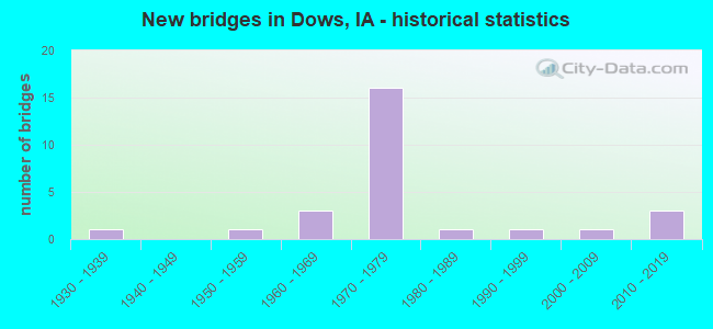
- New bridges - historical statistics
- 11930-1939
- 11950-1959
- 31960-1969
- 161970-1979
- 11980-1989
- 11990-1999
- 12000-2009
- 32010-2019
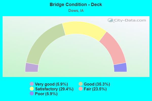
- Bridge Condition - Deck
- 5.9%Very good
- 35.3%Good
- 29.4%Satisfactory
- 23.5%Fair
- 5.9%Poor
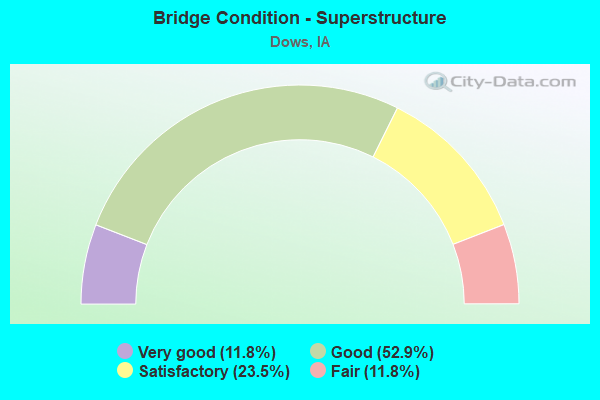
- Bridge Condition - Superstructure
- 11.8%Very good
- 52.9%Good
- 23.5%Satisfactory
- 11.8%Fair
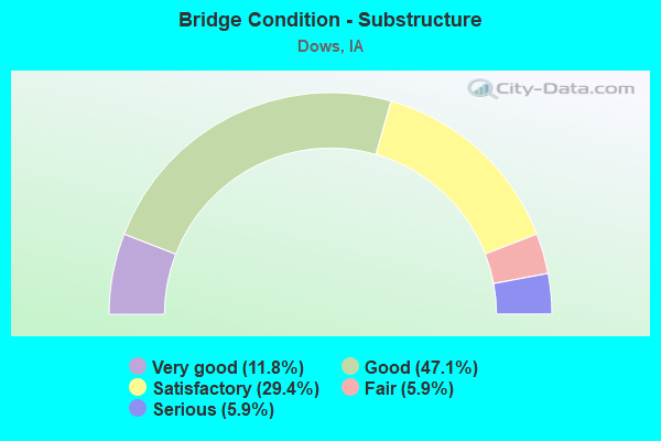
- Bridge Condition - Substructure
- 11.8%Very good
- 47.1%Good
- 29.4%Satisfactory
- 5.9%Fair
- 5.9%Serious
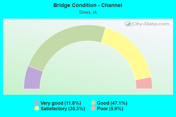
- Bridge Condition - Channel
- 11.8%Very good
- 47.1%Good
- 35.3%Satisfactory
- 5.9%Poor
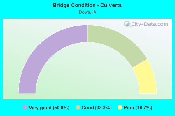
- Bridge Condition - Culverts
- 50.0%Very good
- 33.3%Good
- 16.7%Poor
Find on map >> Show street view
Structure Number: 15722, Location: 091221902 (Lat: 42.674289, Lng: -93.499178), Route carried "on" structure: County highway , Year Built: 1959, Status: Open, Structure Length: 5.91m (19.39ft), Average Daily Traffic: 320 (year 2021), Truck Traffic: 35%, Average Future Daily Traffic: 320 (year 2041), Design Load: H 15, Features Intersected: IOWA RIVER, Facility Carried by Structure: FM
Minimum Vertical Clearance: 30+ m (98+ ft), Kilometerpoint: 4.873, Lanes on structure: 2, Owner: County Highway Agency, Approaching Roadway Width: 6.7m (22.0ft), Material/Design: Prestressed concrete, Design/Construction: Stringer/Multi-beam, Number Of Spans In Main Unit: 3, Length of Maximum Span: 20.7m (67.9ft), Curb-To-Curb Width: 7.3m (24.0ft), Out-to-Out Width: 7.9m (25.9ft)
Condition: Deck: Poor, Superstructure: Good, Substructure: Satisfactory, Channel: Satisfactory, Operating Rating: 51.0 metric tons, Method Used To Determine Operating Rating: Load Factor (LF), Inventory Rating: 20.9 metric tons, Method Used To Determine Inventory Rating: Load Factor (LF), Structural Evaluation: Equal to present minimum criteria, Deck Geometry: Somewhat better than minimum adequacy, Waterway Adequacy: Equal to present minimum criteria, Approach Roadway Alignment: Better than present minimum criteria, Length Of Structure Improvement: 19.40m (63.65ft), Designated Inspection Frequency: Every 24 months, Inspection Date: March 2021, Bridge Improvement Cost: $15,000, Roadway Improvement Cost: $2,000, Deck Structure Type: Concrete Cast-file-Place, Wearing Surface/Protective System: Wearing Surface: Monolithic Concrete
Find on map >> Show street view
Structure Number: 15723, Location: 091222001 (Lat: 42.688161, Lng: -93.473439), Route carried "on" structure: County highway , Year Built: 1936, Status: Open, Structure Length: 0.64m (2.10ft), Average Daily Traffic: 20 (year 2021), Truck Traffic: 40%, Average Future Daily Traffic: 20 (year 2040), Design Load: H 15, Features Intersected: SMALL STREAM, Facility Carried by Structure: 110TH STREET
Minimum Vertical Clearance: 30+ m (98+ ft), Kilometerpoint: 2.099, Lanes on structure: 2, Owner: County Highway Agency, Approaching Roadway Width: 7.9m (25.9ft), Material/Design: Concrete continuous, Design/Construction: Culvert, Number Of Spans In Main Unit: 2, Length of Maximum Span: 3.0m (9.8ft), Curb-To-Curb Width: 8.5m (27.9ft), Out-to-Out Width: 9.1m (29.9ft)
Condition: Channel: Poor, Culverts: Poor, Operating Rating: 23.2 metric tons, Method Used To Determine Operating Rating: Field evaluation and documented engineering judgment, Inventory Rating: 17.0 metric tons, Method Used To Determine Inventory Rating: Field evaluation and documented engineering judgment, Structural Evaluation: Meets minimum limits, Deck Geometry: Better than present minimum criteria, Waterway Adequacy: Equal to present minimum criteria, Approach Roadway Alignment: Equal to present minimum criteria, Length Of Structure Improvement: 3.70m (12.14ft), Designated Inspection Frequency: Every 24 months, Inspection Date: June 2020, Bridge Improvement Cost: $140,000, Roadway Improvement Cost: $20,000
Find on map >> Show street view
Structure Number: 15726, Location: 091222901 (Lat: 42.673686, Lng: -93.476931), Route carried "on" structure: County highway , Year Built: 1961, Year Reconstructed: 2011, Status: Open, Structure Length: 1.34m (4.40ft), Average Daily Traffic: 570 (year 2021), Truck Traffic: 16%, Average Future Daily Traffic: 570 (year 2041), Design Load: H 20, Features Intersected: SMALL STREAM, Facility Carried by Structure: FM 100TH ST
Minimum Vertical Clearance: 30+ m (98+ ft), Kilometerpoint: 1.028, Lanes on structure: 2, Owner: County Highway Agency, Approaching Roadway Width: 6.7m (22.0ft), Material/Design: Prestressed concrete, Design/Construction: Stringer/Multi-beam, Number Of Spans In Main Unit: 1, Length of Maximum Span: 13.1m (43.0ft), Curb or Sidewalk Widths: Left: 0.3m (1.0ft), Right: 0.3m (1.0ft), Curb-To-Curb Width: 8.6m (28.2ft), Out-to-Out Width: 9.2m (30.2ft)
Condition: Deck: Fair, Superstructure: Good, Substructure: Good, Channel: Good, Operating Rating: 51.1 metric tons, Method Used To Determine Operating Rating: Allowable Stress (AS), Inventory Rating: 33.0 metric tons, Method Used To Determine Inventory Rating: Allowable Stress (AS), Structural Evaluation: Better than present minimum criteria, Deck Geometry: Somewhat better than minimum adequacy, Waterway Adequacy: Better than present minimum criteria, Approach Roadway Alignment: Equal to present desirable criteria, Length Of Structure Improvement: 7.50m (24.61ft), Designated Inspection Frequency: Every 24 months, Inspection Date: June 2021, Bridge Improvement Cost: $175,000, Roadway Improvement Cost: $75,000, Deck Structure Type: Concrete Cast-file-Place, Wearing Surface/Protective System: Wearing Surface: Monolithic Concrete
Find on map >> Show street view
Structure Number: 15727, Location: 091222902 (Lat: 42.665764, Lng: -93.478483), Route carried "on" structure: County highway , Year Built: 1969, Status: Open, Structure Length: 2.38m (7.81ft), Average Daily Traffic: 45 (year 2021), Average Future Daily Traffic: 45 (year 2040), Design Load: H 20, Features Intersected: DRAINAGE DITCH #32, Facility Carried by Structure: BALSAM AVE
Minimum Vertical Clearance: 30+ m (98+ ft), Kilometerpoint: 7.118, Lanes on structure: 2, Owner: County Highway Agency, Approaching Roadway Width: 7.9m (25.9ft), Skew: 4 degrees, Material/Design: Concrete continuous, Design/Construction: Slab, Number Of Spans In Main Unit: 3, Length of Maximum Span: 8.8m (28.9ft), Curb-To-Curb Width: 8.5m (27.9ft), Out-to-Out Width: 9.1m (29.9ft)
Condition: Deck: Fair, Superstructure: Fair, Substructure: Satisfactory, Channel: Satisfactory, Operating Rating: 46.2 metric tons, Method Used To Determine Operating Rating: Allowable Stress (AS), Inventory Rating: 26.6 metric tons, Method Used To Determine Inventory Rating: Allowable Stress (AS), Structural Evaluation: Somewhat better than minimum adequacy, Deck Geometry: Better than present minimum criteria, Waterway Adequacy: Better than present minimum criteria, Approach Roadway Alignment: Better than present minimum criteria, Length Of Structure Improvement: 12.50m (41.01ft), Designated Inspection Frequency: Every 24 months, Inspection Date: June 2020, Bridge Improvement Cost: $305,000, Roadway Improvement Cost: $35,000, Deck Structure Type: Concrete Cast-file-Place, Wearing Surface/Protective System: Wearing Surface: Monolithic Concrete
Find on map >> Show street view
Structure Number: 157281, Location: 0.5 miles east of S13 (Lat: 42.667758, Lng: -93.491847), Route carried "on" structure: County highway , Year Built: 2012, Status: Open, Structure Length: 7.41m (24.31ft), Average Daily Traffic: 570 (year 2021), Truck Traffic: 16%, Average Future Daily Traffic: 570 (year 2041), Design Load: HL 93, Features Intersected: IOWA RIVER, Facility Carried by Structure: C 47 (95TH ST)
Minimum Vertical Clearance: 30+ m (98+ ft), Kilometerpoint: 0.676, Lanes on structure: 2, Owner: County Highway Agency, Approaching Roadway Width: 10.4m (34.1ft), Skew: 3 degrees, Material/Design: Prestressed concrete, Design/Construction: Stringer/Multi-beam, Number Of Spans In Main Unit: 3, Length of Maximum Span: 24.8m (81.4ft), Curb-To-Curb Width: 9.3m (30.5ft), Out-to-Out Width: 10.1m (33.1ft)
Condition: Deck: Satisfactory, Superstructure: Very good, Substructure: Very good, Channel: Good, Inventory Rating: 42.8 metric tons, Method Used To Determine Inventory Rating: Load Factor (LF), Structural Evaluation: Equal to present desirable criteria, Deck Geometry: Equal to present minimum criteria, Waterway Adequacy: Equal to present desirable criteria, Approach Roadway Alignment: Better than present minimum criteria, Designated Inspection Frequency: Every 48 months, Inspection Date: June 2021, Deck Structure Type: Concrete Cast-file-Place, Wearing Surface/Protective System: Wearing Surface: Monolithic Concrete, Deck Protection: Epoxy Coated Reinforcing
Find on map >> Show street view
Structure Number: 157291, Location: 091223103 (Lat: 42.653683, Lng: -93.488261), Route carried "on" structure: County highway , Year Built: 1978, Status: Open, Structure Length: 7.50m (24.61ft), Average Daily Traffic: 580 (year 2021), Truck Traffic: 24%, Average Future Daily Traffic: 580 (year 2041), Design Load: H 20, Features Intersected: IOWA RIVER, Facility Carried by Structure: FM S13
Minimum Vertical Clearance: 30+ m (98+ ft), Kilometerpoint: 0.798, Lanes on structure: 2, Owner: County Highway Agency, Approaching Roadway Width: 6.7m (22.0ft), Material/Design: Prestressed concrete, Design/Construction: Stringer/Multi-beam, Number Of Spans In Main Unit: 3, Length of Maximum Span: 25.0m (82.0ft), Curb-To-Curb Width: 9.1m (29.9ft), Out-to-Out Width: 9.8m (32.2ft)
Condition: Deck: Fair, Superstructure: Satisfactory, Substructure: Good, Channel: Satisfactory, Operating Rating: 77.2 metric tons, Method Used To Determine Operating Rating: Allowable Stress (AS), Inventory Rating: 30.8 metric tons, Method Used To Determine Inventory Rating: Allowable Stress (AS), Structural Evaluation: Equal to present minimum criteria, Deck Geometry: Equal to present minimum criteria, Waterway Adequacy: Better than present minimum criteria, Approach Roadway Alignment: Somewhat better than minimum adequacy, Length Of Structure Improvement: 24.30m (79.72ft), Designated Inspection Frequency: Every 24 months, Underwater Inspection Frequency: Every 60 months, Inspection Date: June 2021, Underwater Inspection Date: September 2017, Bridge Improvement Cost: $15,000, Roadway Improvement Cost: $2,000, Deck Structure Type: Concrete Cast-file-Place, Wearing Surface/Protective System: Wearing Surface: Monolithic Concrete
Find on map >> Show street view
Structure Number: 35656, Location: 090230203 (Lat: 42.633803, Lng: -93.537272), Route carried "on" structure: County highway , Year Built: 1963, Status: Posted for load, Structure Length: 0.73m (2.40ft), Average Daily Traffic: 70 (year 2015), Average Future Daily Traffic: 70 (year 2041), Design Load: H 15, Features Intersected: DRAINAGE DITCH 7, Facility Carried by Structure: LOCAL
Minimum Vertical Clearance: 30+ m (98+ ft), Kilometerpoint: 32.124, Lanes on structure: 2, Owner: County Highway Agency, Approaching Roadway Width: 7.3m (24.0ft), Skew: 3 degrees, Material/Design: Concrete, Design/Construction: Slab, Number Of Spans In Main Unit: 1, Length of Maximum Span: 7.0m (23.0ft), Curb-To-Curb Width: 7.3m (24.0ft), Out-to-Out Width: 8.0m (26.2ft)
Condition: Deck: Fair, Superstructure: Fair, Substructure: Serious, Channel: Satisfactory, Operating Rating: 31.4 metric tons, Method Used To Determine Operating Rating: Allowable Stress (AS), Inventory Rating: 18.1 metric tons, Method Used To Determine Inventory Rating: Allowable Stress (AS), Structural Evaluation: High priority of corrective action, Deck Geometry: Equal to present minimum criteria, Waterway Adequacy: Equal to present minimum criteria, Approach Roadway Alignment: Better than present minimum criteria, Bridge Posting: Required (Relationship of Operating Rating to Maximum Legal Load: 0.1 - 9.9% below), Length Of Structure Improvement: 5.00m (16.40ft), Designated Inspection Frequency: Every 12 months, Inspection Date: March 2021, Bridge Improvement Cost: $108,000, Roadway Improvement Cost: $11,000, Deck Structure Type: Concrete Cast-file-Place, Wearing Surface/Protective System: Wearing Surface: Monolithic Concrete
Find on map >> Show street view
Structure Number: 356591, Location: 090231103 (Lat: 42.623003, Lng: -93.536386), Route carried "on" structure: County highway , Year Built: 2012, Status: Open, Structure Length: 1.10m (3.61ft), Average Daily Traffic: 10 (year 2015), Average Future Daily Traffic: 10 (year 2039), Design Load: HL 93, Features Intersected: DRAINAGE DITCH #7, Facility Carried by Structure: 295TH ST
Minimum Vertical Clearance: 30+ m (98+ ft), Kilometerpoint: 3.389, Lanes on structure: 2, Owner: County Highway Agency, Approaching Roadway Width: 7.3m (24.0ft), Skew: 3 degrees, Material/Design: Concrete continuous, Design/Construction: Culvert, Number Of Spans In Main Unit: 2, Length of Maximum Span: 5.2m (17.1ft)
Condition: Channel: Very good, Culverts: Very good, Operating Rating: 43.7 metric tons, Method Used To Determine Operating Rating: Assigned ratings based on Load and Resistance Factor Design (LRFD) reported by rating factor (RF) using HL93 loadings, Inventory Rating: 32.4 metric tons, Method Used To Determine Inventory Rating: Assigned ratings based on Load and Resistance Factor Design (LRFD) reported by rating factor (RF) using HL93 loadings, Structural Evaluation: Equal to present desirable criteria, Waterway Adequacy: Equal to present desirable criteria, Approach Roadway Alignment: Equal to present desirable criteria, Designated Inspection Frequency: Every 48 months, Inspection Date: April 2019
Find on map >> Show street view
Structure Number: 356601, Location: 090231206 (Lat: 42.620444, Lng: -93.514408), Route carried "on" structure: County highway , Year Built: 2002, Status: Open, Structure Length: 0.67m (2.20ft), Average Daily Traffic: 390 (year 2019), Truck Traffic: 15%, Average Future Daily Traffic: 390 (year 2040), Design Load: HS 20, Features Intersected: DRAINAGE DITCH, Facility Carried by Structure: FM
Minimum Vertical Clearance: 30+ m (98+ ft), Kilometerpoint: 9.297, Lanes on structure: 2, Owner: County Highway Agency, Approaching Roadway Width: 8.5m (27.9ft), Material/Design: Concrete continuous, Design/Construction: Culvert, Number Of Spans In Main Unit: 2, Length of Maximum Span: 3.0m (9.8ft)
Condition: Channel: Good, Culverts: Very good, Operating Rating: 44.1 metric tons, Method Used To Determine Operating Rating: Assigned rating based on Load Factor Design (LFD) reported in metric tons, Inventory Rating: 32.7 metric tons, Method Used To Determine Inventory Rating: Assigned rating based on Load Factor Design (LFD) reported in metric tons, Structural Evaluation: Equal to present desirable criteria, Waterway Adequacy: Better than present minimum criteria, Approach Roadway Alignment: Equal to present desirable criteria, Length Of Structure Improvement: 1.00m (3.28ft), Designated Inspection Frequency: Every 48 months, Inspection Date: March 2020, Bridge Improvement Cost: $15,000, Roadway Improvement Cost: $2,000
Find on map >> Show street view
Structure Number: 356611, Location: 090231309 (Lat: 42.608517, Lng: -93.502172), Route carried "on" structure: County highway , Year Built: 1975, Status: Open, Structure Length: 7.50m (24.61ft), Average Daily Traffic: 45 (year 2015), Average Future Daily Traffic: 45 (year 2040), Design Load: H 20, Features Intersected: IOWA RIVER, Facility Carried by Structure: LOCAL
Minimum Vertical Clearance: 30+ m (98+ ft), Kilometerpoint: 6.862, Lanes on structure: 2, Owner: County Highway Agency, Approaching Roadway Width: 11.6m (38.1ft), Skew: 2 degrees, Material/Design: Prestressed concrete, Design/Construction: Stringer/Multi-beam, Number Of Spans In Main Unit: 3, Length of Maximum Span: 25.0m (82.0ft), Curb-To-Curb Width: 9.1m (29.9ft), Out-to-Out Width: 9.8m (32.2ft)
Condition: Deck: Satisfactory, Superstructure: Good, Substructure: Good, Channel: Good, Operating Rating: 77.2 metric tons, Method Used To Determine Operating Rating: Allowable Stress (AS), Inventory Rating: 30.8 metric tons, Method Used To Determine Inventory Rating: Allowable Stress (AS), Structural Evaluation: Better than present minimum criteria, Deck Geometry: Better than present minimum criteria, Waterway Adequacy: Better than present minimum criteria, Approach Roadway Alignment: Better than present minimum criteria, Length Of Structure Improvement: 24.60m (80.71ft), Designated Inspection Frequency: Every 24 months, Inspection Date: March 2020, Bridge Improvement Cost: $15,000, Roadway Improvement Cost: $2,000, Deck Structure Type: Concrete Cast-file-Place, Wearing Surface/Protective System: Wearing Surface: Monolithic Concrete
Find on map >> Show street view
Structure Number: 356621, Location: 090232305 (Lat: 42.593981, Lng: -93.519578), Route carried "on" structure: County highway , Year Built: 1978, Status: Open, Structure Length: 1.55m (5.09ft), Average Daily Traffic: 35 (year 2015), Average Future Daily Traffic: 35 (year 2040), Design Load: H 20, Features Intersected: DD #29, Facility Carried by Structure: YANKEE AVE
Minimum Vertical Clearance: 30+ m (98+ ft), Kilometerpoint: 2.831, Lanes on structure: 2, Owner: County Highway Agency, Approaching Roadway Width: 7.3m (24.0ft), Material/Design: Prestressed concrete, Design/Construction: Tee Beam, Number Of Spans In Main Unit: 1, Length of Maximum Span: 15.2m (49.9ft), Curb-To-Curb Width: 7.8m (25.6ft), Out-to-Out Width: 8.6m (28.2ft)
Condition: Deck: Satisfactory, Superstructure: Satisfactory, Substructure: Fair, Channel: Satisfactory, Operating Rating: 69.2 metric tons, Method Used To Determine Operating Rating: Load Factor (LF), Inventory Rating: 35.0 metric tons, Method Used To Determine Inventory Rating: Load Factor (LF), Structural Evaluation: Somewhat better than minimum adequacy, Deck Geometry: Equal to present minimum criteria, Waterway Adequacy: Equal to present minimum criteria, Approach Roadway Alignment: Equal to present minimum criteria, Length Of Structure Improvement: 5.10m (16.73ft), Designated Inspection Frequency: Every 24 months, Inspection Date: March 2020, Bridge Improvement Cost: $15,000, Roadway Improvement Cost: $2,000, Deck Structure Type: Concrete Cast-file-Place, Wearing Surface/Protective System: Wearing Surface: Monolithic Concrete
Find on map >> Show street view
Structure Number: 356641, Location: 090232404 (Lat: 42.597350, Lng: -93.509364), Route carried "on" structure: County highway , Year Built: 2018, Status: Open, Structure Length: 0.76m (2.49ft), Average Daily Traffic: 40 (year 2015), Average Future Daily Traffic: 40 (year 2040), Design Load: HL 93, Features Intersected: DD #29, Facility Carried by Structure: YOUNGBLOOD AVE
Minimum Vertical Clearance: 30+ m (98+ ft), Kilometerpoint: 2.390, Lanes on structure: 2, Owner: County Highway Agency, Approaching Roadway Width: 8.2m (26.9ft), Skew: 1 degrees, Material/Design: Concrete, Design/Construction: Culvert, Number Of Spans In Main Unit: 2, Length of Maximum Span: 3.7m (12.1ft)
Condition: Channel: Very good, Culverts: Very good, Operating Rating: 42.1 metric tons, Method Used To Determine Operating Rating: Assigned ratings based on Load and Resistance Factor Design (LRFD) reported by rating factor (RF) using HL93 loadings, Inventory Rating: 32.4 metric tons, Method Used To Determine Inventory Rating: Assigned ratings based on Load and Resistance Factor Design (LRFD) reported by rating factor (RF) using HL93 loadings, Structural Evaluation: Equal to present desirable criteria, Waterway Adequacy: Equal to present desirable criteria, Approach Roadway Alignment: Better than present minimum criteria, Designated Inspection Frequency: Every 48 months, Inspection Date: March 2020
Find on map >> Show street view
Structure Number: 357361, Location: 091232402 (Lat: 42.682603, Lng: -93.517231), Route carried "on" structure: County highway , Year Built: 1998, Status: Open, Structure Length: 7.50m (24.61ft), Average Daily Traffic: 20 (year 2015), Average Future Daily Traffic: 20 (year 2040), Design Load: HS 20, Features Intersected: IOWA RIVER, Facility Carried by Structure: LOCAL
Minimum Vertical Clearance: 30+ m (98+ ft), Kilometerpoint: 4.043, Lanes on structure: 2, Owner: County Highway Agency, Approaching Roadway Width: 9.1m (29.9ft), Material/Design: Prestressed concrete, Design/Construction: Stringer/Multi-beam, Number Of Spans In Main Unit: 3, Length of Maximum Span: 24.7m (81.0ft), Curb-To-Curb Width: 7.5m (24.6ft), Out-to-Out Width: 7.9m (25.9ft)
Condition: Deck: Very good, Superstructure: Very good, Substructure: Very good, Channel: Good, Operating Rating: 83.6 metric tons, Method Used To Determine Operating Rating: Load Factor (LF), Inventory Rating: 34.6 metric tons, Method Used To Determine Inventory Rating: Load Factor (LF), Structural Evaluation: Equal to present desirable criteria, Deck Geometry: Equal to present minimum criteria, Waterway Adequacy: Better than present minimum criteria, Approach Roadway Alignment: Better than present minimum criteria, Length Of Structure Improvement: 24.60m (80.71ft), Designated Inspection Frequency: Every 48 months, Inspection Date: March 2020, Bridge Improvement Cost: $15,000, Roadway Improvement Cost: $2,000, Deck Structure Type: Concrete Cast-file-Place, Wearing Surface/Protective System: Wearing Surface: Monolithic Concrete
Find on map >> Show street view
Structure Number: 362595, Location: 091221702 (Lat: 42.692956, Lng: -93.478631), Route carried "on" structure: County highway , Year Built: 1985, Status: Open, Structure Length: 0.88m (2.89ft), Average Daily Traffic: 35 (year 2013), Average Future Daily Traffic: 35 (year 2040), Design Load: HS 20, Features Intersected: DD#32, Facility Carried by Structure: BALSAM AVE
Minimum Vertical Clearance: 30+ m (98+ ft), Kilometerpoint: 10.137, Lanes on structure: 2, Owner: County Highway Agency, Approaching Roadway Width: 11.6m (38.1ft), Material/Design: Concrete continuous, Design/Construction: Culvert, Number Of Spans In Main Unit: 2, Length of Maximum Span: 3.7m (12.1ft)
Condition: Channel: Good, Culverts: Good, Operating Rating: 44.1 metric tons, Method Used To Determine Operating Rating: Assigned rating based on Load Factor Design (LFD) reported in metric tons, Inventory Rating: 32.7 metric tons, Method Used To Determine Inventory Rating: Assigned rating based on Load Factor Design (LFD) reported in metric tons, Structural Evaluation: Better than present minimum criteria, Waterway Adequacy: Better than present minimum criteria, Approach Roadway Alignment: Better than present minimum criteria, Length Of Structure Improvement: 3.00m (9.84ft), Designated Inspection Frequency: Every 24 months, Inspection Date: June 2020, Bridge Improvement Cost: $100,000, Roadway Improvement Cost: $25,000
Find on map >> Show street view
Structure Number: 60236, Location: 2.9 mi. S of C47 (Lat: 42.635767, Lng: -93.479539), Route carried "on" structure: Interstate 35, Year Built: 1974, Status: Open, Structure Length: 5.49m (18.01ft), Average Daily Traffic: 6,850 (year 2020), Truck Traffic: 32%, Average Future Daily Traffic: 6,850 (year 2041), Design Load: HS 20, Features Intersected: ABAND RR
Minimum Vertical Clearance: 30+ m (98+ ft), Kilometerpoint: 252.638, Lanes on structure: 2, Base Highway Network: Yes, Owner: State Highway Agency, Approaching Roadway Width: 12.2m (40.0ft), Skew: 2 degrees, Material/Design: Prestressed concrete, Design/Construction: Stringer/Multi-beam, Number Of Spans In Main Unit: 3, Length of Maximum Span: 19.8m (65.0ft), Curb or Sidewalk Widths: Left: 0.3m (1.0ft), Right: 0.3m (1.0ft), Curb-To-Curb Width: 12.2m (40.0ft), Out-to-Out Width: 13.2m (43.3ft)
Condition: Deck: Good, Superstructure: Good, Substructure: Good, Operating Rating: 61.9 metric tons, Method Used To Determine Operating Rating: Allowable Stress (AS), Inventory Rating: 42.2 metric tons, Method Used To Determine Inventory Rating: Allowable Stress (AS), Structural Evaluation: Better than present minimum criteria, Deck Geometry: Better than present minimum criteria, Approach Roadway Alignment: Equal to present desirable criteria, Designated Inspection Frequency: Every 24 months, Inspection Date: July 2021, Deck Structure Type: Concrete Cast-file-Place, Wearing Surface/Protective System: Wearing Surface: Low Slump Concrete
Find on map >> Show street view
Structure Number: 60237, Location: 2.9 MI. S OF SR C47 (Lat: 42.636436, Lng: -93.479581), Route carried "on" structure: Interstate 35, Year Built: 1974, Status: Open, Structure Length: 5.49m (18.01ft), Average Daily Traffic: 6,850 (year 2020), Truck Traffic: 32%, Average Future Daily Traffic: 6,850 (year 2041), Design Load: HS 20, Features Intersected: ABAND RR
Minimum Vertical Clearance: 30+ m (98+ ft), Kilometerpoint: 98.976, Lanes on structure: 2, Owner: State Highway Agency, Approaching Roadway Width: 12.2m (40.0ft), Skew: 4 degrees, Material/Design: Prestressed concrete, Design/Construction: Stringer/Multi-beam, Number Of Spans In Main Unit: 3, Length of Maximum Span: 19.8m (65.0ft), Curb or Sidewalk Widths: Left: 0.3m (1.0ft), Right: 0.3m (1.0ft), Curb-To-Curb Width: 12.2m (40.0ft), Out-to-Out Width: 13.2m (43.3ft)
Condition: Deck: Satisfactory, Superstructure: Good, Substructure: Good, Operating Rating: 61.0 metric tons, Method Used To Determine Operating Rating: Allowable Stress (AS), Inventory Rating: 41.3 metric tons, Method Used To Determine Inventory Rating: Allowable Stress (AS), Structural Evaluation: Better than present minimum criteria, Deck Geometry: Better than present minimum criteria, Approach Roadway Alignment: Equal to present desirable criteria, Designated Inspection Frequency: Every 24 months, Inspection Date: July 2021, Deck Structure Type: Concrete Cast-file-Place, Wearing Surface/Protective System: Wearing Surface: Low Slump Concrete
Find on map >> Show street view
Structure Number: 602425, Location: 5.2 mi. N of Jct. SR C70 (Lat: 42.630189, Lng: -93.483342), Route carried "on" structure: County highway , Year Built: 1972, Status: Open, Structure Length: 9.57m (31.40ft), Average Daily Traffic: 400 (year 2021), Truck Traffic: 25%, Average Future Daily Traffic: 400 (year 2040), Design Load: H 20, Features Intersected: I-35, Facility Carried by Structure: CO S-13
Minimum Vertical Clearance: 30+ m (98+ ft), Kilometerpoint: 0.414, Lanes on structure: 2, Lanes under structure: 4, Owner: State Highway Agency, Approaching Roadway Width: 11.6m (38.1ft), Skew: 2 degrees, Material/Design: Steel continuous, Design/Construction: Stringer/Multi-beam, Number Of Spans In Main Unit: 4, Length of Maximum Span: 30.5m (100.1ft), Curb-To-Curb Width: 9.1m (29.9ft), Out-to-Out Width: 10.2m (33.5ft)
Condition: Deck: Satisfactory, Superstructure: Satisfactory, Substructure: Good, Operating Rating: 43.3 metric tons, Method Used To Determine Operating Rating: Load Factor (LF), Inventory Rating: 25.9 metric tons, Method Used To Determine Inventory Rating: Load Factor (LF), Structural Evaluation: Equal to present minimum criteria, Deck Geometry: Equal to present minimum criteria, Underclear: Somewhat better than minimum adequacy, Approach Roadway Alignment: Better than present minimum criteria, Designated Inspection Frequency: Every 24 months, Inspection Date: June 2020, Deck Structure Type: Concrete Cast-file-Place, Wearing Surface/Protective System: Wearing Surface: Monolithic Concrete
Find on map >> Show street view
Structure Number: 602435, Location: 7.3 mi. N of Jct. SR C70 (Lat: 42.651933, Lng: -93.470764), Route carried "on" structure: County highway , Year Built: 1972, Status: Open, Structure Length: 9.91m (32.51ft), Average Daily Traffic: 90 (year 2013), Average Future Daily Traffic: 90 (year 2041), Design Load: H 20, Features Intersected: I-35, Facility Carried by Structure: 85TH STREET
Minimum Vertical Clearance: 30+ m (98+ ft), Kilometerpoint: 1.465, Lanes on structure: 2, Lanes under structure: 4, Owner: State Highway Agency, Approaching Roadway Width: 9.1m (29.9ft), Skew: 2 degrees, Material/Design: Steel continuous, Design/Construction: Stringer/Multi-beam, Number Of Spans In Main Unit: 4, Length of Maximum Span: 31.7m (104.0ft), Curb or Sidewalk Widths: Left: 0.3m (1.0ft), Right: 0.3m (1.0ft), Curb-To-Curb Width: 9.1m (29.9ft), Out-to-Out Width: 10.2m (33.5ft)
Condition: Deck: Good, Superstructure: Good, Substructure: Good, Operating Rating: 45.2 metric tons, Method Used To Determine Operating Rating: Load Factor (LF), Inventory Rating: 27.0 metric tons, Method Used To Determine Inventory Rating: Load Factor (LF), Structural Evaluation: Equal to present minimum criteria, Deck Geometry: Better than present minimum criteria, Underclear: Somewhat better than minimum adequacy, Approach Roadway Alignment: Better than present minimum criteria, Designated Inspection Frequency: Every 24 months, Inspection Date: July 2021, Deck Structure Type: Concrete Cast-file-Place, Wearing Surface/Protective System: Wearing Surface: Monolithic Concrete
Find on map >> Show street view
Structure Number: 602445, Location: 0.3 MI S OF SR C47 (Lat: 42.669781, Lng: -93.458217), Route carried "on" structure: Interstate 35, Year Built: 1974, Status: Open, Structure Length: 0.79m (2.59ft), Average Daily Traffic: 12,700 (year 2020), Truck Traffic: 31%, Average Future Daily Traffic: 12,700 (year 2040), Design Load: HS 20, Features Intersected: DRAINAGE DITCH NO.48
Minimum Vertical Clearance: 30+ m (98+ ft), Kilometerpoint: 256.801, Lanes on structure: 6, Base Highway Network: Yes, Owner: State Highway Agency, Approaching Roadway Width: 24.4m (80.1ft), Skew: 20 degrees, Material/Design: Concrete continuous, Design/Construction: Culvert, Number Of Spans In Main Unit: 2, Length of Maximum Span: 3.7m (12.1ft)
Condition: Channel: Satisfactory, Culverts: Good, Operating Rating: 38.6 metric tons, Method Used To Determine Operating Rating: Load Factor (LF) rating reported by rating factor (RF) method using MS18 loading, Inventory Rating: 23.0 metric tons, Method Used To Determine Inventory Rating: Load Factor (LF) rating reported by rating factor (RF) method using MS18 loading, Structural Evaluation: Somewhat better than minimum adequacy, Waterway Adequacy: Equal to present minimum criteria, Approach Roadway Alignment: Equal to present desirable criteria, Designated Inspection Frequency: Every 24 months, Inspection Date: November 2020
Find on map >> Show street view
Structure Number: 602455, Location: AT JCT. I-35 & SR C47 (Lat: 42.673658, Lng: -93.456417), Route carried "on" structure: County highway , Year Built: 1972, Status: Open, Structure Length: 9.91m (32.51ft), Average Daily Traffic: 1,180 (year 2021), Truck Traffic: 22%, Average Future Daily Traffic: 1,180 (year 2040), Design Load: HS 20, Features Intersected: I-35, Facility Carried by Structure: C 47
Minimum Vertical Clearance: 30+ m (98+ ft), Kilometerpoint: 2.710, Lanes on structure: 2, Lanes under structure: 4, Owner: State Highway Agency, Approaching Roadway Width: 13.4m (44.0ft), Skew: 2 degrees, Material/Design: Steel continuous, Design/Construction: Stringer/Multi-beam, Number Of Spans In Main Unit: 4, Length of Maximum Span: 31.7m (104.0ft), Curb-To-Curb Width: 9.8m (32.2ft), Out-to-Out Width: 10.8m (35.4ft)
Condition: Deck: Good, Superstructure: Satisfactory, Substructure: Satisfactory, Operating Rating: 49.7 metric tons, Method Used To Determine Operating Rating: Load Factor (LF), Inventory Rating: 29.8 metric tons, Method Used To Determine Inventory Rating: Load Factor (LF), Structural Evaluation: Equal to present minimum criteria, Deck Geometry: Somewhat better than minimum adequacy, Underclear: Somewhat better than minimum adequacy, Approach Roadway Alignment: Equal to present minimum criteria, Designated Inspection Frequency: Every 24 months, Inspection Date: June 2020, Deck Structure Type: Concrete Cast-file-Place, Wearing Surface/Protective System: Wearing Surface: Low Slump Concrete
Find on map >> Show street view
Structure Number: 602605, Location: 3.3 mi. N of Jct. SR R75 (Lat: 42.608517, Lng: -93.506553), Route carried "on" structure: County highway , Year Built: 1974, Status: Open, Structure Length: 11.92m (39.11ft), Average Daily Traffic: 80 (year 2015), Average Future Daily Traffic: 80 (year 2040), Design Load: H 20, Features Intersected: I-35, Facility Carried by Structure: 305TH ST
Minimum Vertical Clearance: 30+ m (98+ ft), Kilometerpoint: 6.503, Lanes on structure: 2, Lanes under structure: 4, Owner: State Highway Agency, Approaching Roadway Width: 9.1m (29.9ft), Skew: 4 degrees, Material/Design: Steel continuous, Design/Construction: Stringer/Multi-beam, Number Of Spans In Main Unit: 4, Length of Maximum Span: 38.1m (125.0ft), Curb or Sidewalk Widths: Left: 0.3m (1.0ft), Right: 0.3m (1.0ft), Curb-To-Curb Width: 9.1m (29.9ft), Out-to-Out Width: 10.2m (33.5ft)
Condition: Deck: Good, Superstructure: Good, Substructure: Good, Operating Rating: 42.0 metric tons, Method Used To Determine Operating Rating: Load Factor (LF), Inventory Rating: 25.2 metric tons, Method Used To Determine Inventory Rating: Load Factor (LF), Structural Evaluation: Equal to present minimum criteria, Deck Geometry: Better than present minimum criteria, Underclear: Somewhat better than minimum adequacy, Approach Roadway Alignment: Equal to present minimum criteria, Designated Inspection Frequency: Every 24 months, Inspection Date: May 2020, Deck Structure Type: Concrete Cast-file-Place, Wearing Surface/Protective System: Wearing Surface: Monolithic Concrete
Find on map >> Show street view
Structure Number: 60261, Location: 4.0 mi. N of SR C-70 (Lat: 42.610536, Lng: -93.503206), Route carried "on" structure: Interstate 35, Year Built: 1974, Status: Open, Structure Length: 8.96m (29.40ft), Average Daily Traffic: 6,850 (year 2020), Truck Traffic: 32%, Average Future Daily Traffic: 6,850 (year 2042), Design Load: HS 20, Features Intersected: IOWA RIVER
Minimum Vertical Clearance: 30+ m (98+ ft), Kilometerpoint: 249.197, Lanes on structure: 2, Base Highway Network: Yes, Owner: State Highway Agency, Approaching Roadway Width: 12.2m (40.0ft), Skew: 3 degrees, Material/Design: Prestressed concrete, Design/Construction: Stringer/Multi-beam, Number Of Spans In Main Unit: 3, Length of Maximum Span: 29.6m (97.1ft), Curb or Sidewalk Widths: Left: 0.3m (1.0ft), Right: 0.3m (1.0ft), Curb-To-Curb Width: 12.2m (40.0ft), Out-to-Out Width: 13.2m (43.3ft)
Condition: Deck: Good, Superstructure: Good, Substructure: Satisfactory, Channel: Good, Operating Rating: 77.9 metric tons, Method Used To Determine Operating Rating: Load Factor (LF), Inventory Rating: 22.7 metric tons, Method Used To Determine Inventory Rating: Load Factor (LF), Structural Evaluation: Somewhat better than minimum adequacy, Deck Geometry: Better than present minimum criteria, Waterway Adequacy: Equal to present minimum criteria, Approach Roadway Alignment: Equal to present desirable criteria, Designated Inspection Frequency: Every 24 months, Inspection Date: January 2022, Deck Structure Type: Concrete Cast-file-Place, Wearing Surface/Protective System: Wearing Surface: Low Slump Concrete
Find on map >> Show street view
Structure Number: 60262, Location: 4.0 mi. N of SR C 70 (Lat: 42.611319, Lng: -93.502803), Route carried "on" structure: Interstate 35, Year Built: 1974, Status: Open, Structure Length: 8.96m (29.40ft), Average Daily Traffic: 6,850 (year 2020), Truck Traffic: 32%, Average Future Daily Traffic: 6,850 (year 2042), Design Load: HS 20, Features Intersected: IOWA RIVER
Minimum Vertical Clearance: 30+ m (98+ ft), Kilometerpoint: 102.386, Lanes on structure: 2, Owner: State Highway Agency, Approaching Roadway Width: 12.2m (40.0ft), Skew: 3 degrees, Material/Design: Prestressed concrete, Design/Construction: Stringer/Multi-beam, Number Of Spans In Main Unit: 3, Length of Maximum Span: 29.6m (97.1ft), Curb or Sidewalk Widths: Left: 0.3m (1.0ft), Right: 0.3m (1.0ft), Curb-To-Curb Width: 12.2m (40.0ft), Out-to-Out Width: 13.2m (43.3ft)
Condition: Deck: Good, Superstructure: Good, Substructure: Satisfactory, Channel: Good, Operating Rating: 75.0 metric tons, Method Used To Determine Operating Rating: Load Factor (LF), Inventory Rating: 27.2 metric tons, Method Used To Determine Inventory Rating: Load Factor (LF), Structural Evaluation: Equal to present minimum criteria, Deck Geometry: Better than present minimum criteria, Waterway Adequacy: Better than present minimum criteria, Approach Roadway Alignment: Equal to present desirable criteria, Designated Inspection Frequency: Every 24 months, Inspection Date: January 2022, Deck Structure Type: Concrete Cast-file-Place, Wearing Surface/Protective System: Wearing Surface: Low Slump Concrete
Find on map >> Show street view
Structure Number: 602425, Location: 5.2 mi. N of Jct. SR C70 (Lat: 42.630189, Lng: -93.483342), Route carried "under" structure: Interstate 35, Year Built: 1972, Structure Length: 0. m, Average Daily Traffic: 13,700 (year 2020), Truck Traffic: 32%, Features Intersected: I-35, Facility Carried by Structure: CO S-13
Minimum Vertical Clearance: 30+ m (98+ ft), Kilometerpoint: 251.972, Lanes on structure: 2, Lanes under structure: 4, Material/Design: Steel continuous, Design/Construction: Stringer/Multi-beam, Length of Maximum Span: 30.5m (100.1ft)
Find on map >> Show street view
Structure Number: 602435, Location: 7.3 mi. N of Jct. SR C70 (Lat: 42.651933, Lng: -93.470764), Route carried "under" structure: Interstate 35, Year Built: 1972, Structure Length: 0. m, Average Daily Traffic: 13,700 (year 2020), Truck Traffic: 32%, Features Intersected: I-35, Facility Carried by Structure: 85TH STREET
Minimum Vertical Clearance: 30+ m (98+ ft), Kilometerpoint: 254.597, Lanes on structure: 2, Lanes under structure: 4, Material/Design: Steel continuous, Design/Construction: Stringer/Multi-beam, Length of Maximum Span: 31.7m (104.0ft)
Find on map >> Show street view
Structure Number: 602455, Location: AT JCT. I-35 & SR C47 (Lat: 42.673658, Lng: -93.456417), Route carried "under" structure: Interstate 35, Year Built: 1972, Structure Length: 0. m, Average Daily Traffic: 12,700 (year 2020), Truck Traffic: 31%, Features Intersected: I-35, Facility Carried by Structure: C 47
Minimum Vertical Clearance: 30+ m (98+ ft), Kilometerpoint: 257.271, Lanes on structure: 2, Lanes under structure: 4, Material/Design: Steel continuous, Design/Construction: Stringer/Multi-beam, Length of Maximum Span: 31.7m (104.0ft)
Find on map >> Show street view
Structure Number: 602605, Location: 3.3 mi. N of Jct. SR R75 (Lat: 42.608517, Lng: -93.506553), Route carried "under" structure: Interstate 35, Year Built: 1974, Structure Length: 0. m, Average Daily Traffic: 13,700 (year 2020), Truck Traffic: 32%, Features Intersected: I-35, Facility Carried by Structure: 305TH ST
Minimum Vertical Clearance: 30+ m (98+ ft), Kilometerpoint: 248.893, Lanes on structure: 2, Lanes under structure: 4, Material/Design: Steel continuous, Design/Construction: Stringer/Multi-beam, Length of Maximum Span: 38.1m (125.0ft)