Bridge Statistics for Draper, South Dakota (SD)
Condition, Traffic, Stress, Structural Evaluation, Project Costs
- National Bridge Inventory (NBI) Statistics
- 13Number of bridges
- 79ft / 23.9mTotal length
- $14,000Total costs
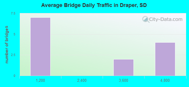
- 22,515Total average daily traffic
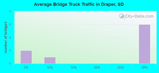
- 5,729Total average daily truck traffic
- National Bridge Inventory (NBI) Registered Bridges for Draper
- No street view available for this location
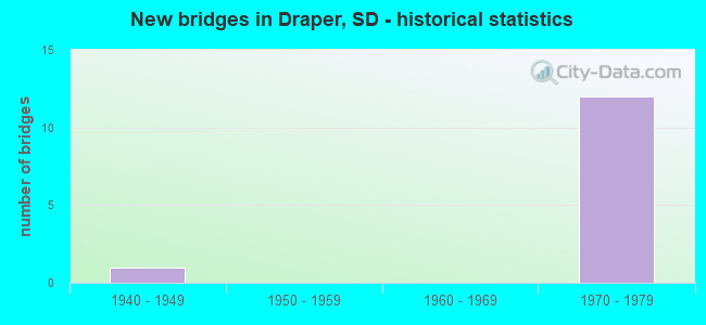
- New bridges - historical statistics
- 11940-1949
- 121970-1979
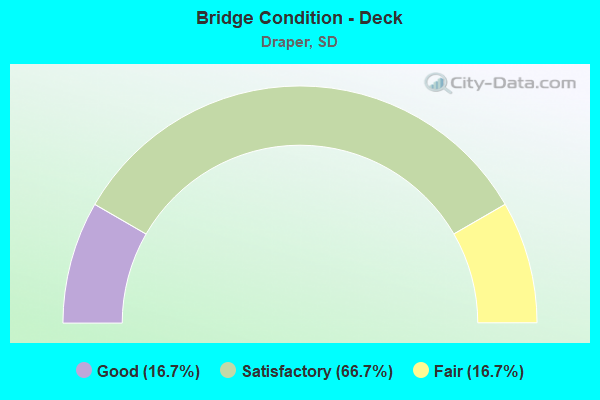
- Bridge Condition - Deck
- 16.7%Good
- 66.7%Satisfactory
- 16.7%Fair
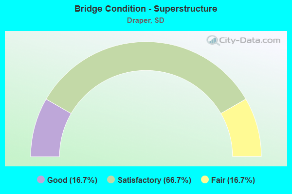
- Bridge Condition - Superstructure
- 16.7%Good
- 66.7%Satisfactory
- 16.7%Fair
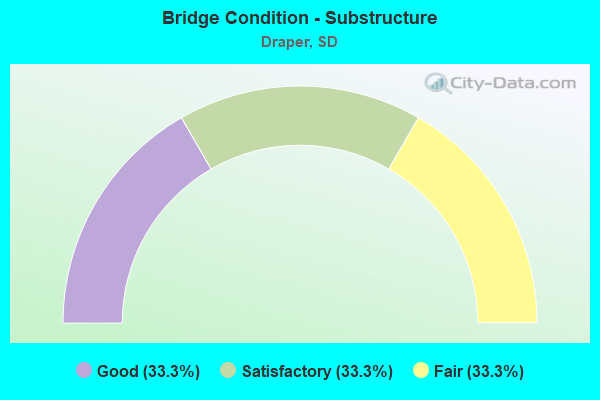
- Bridge Condition - Substructure
- 33.3%Good
- 33.3%Satisfactory
- 33.3%Fair
Find on map >> Show street view
Structure Number: 38240178, Location: 2 W DRAPER INTERCH (Lat: 43.908839, Lng: -100.586300), Route carried "on" structure: Interstate 90, Year Built: 1970, Status: Open, Structure Length: 3.63m (11.91ft), Average Daily Traffic: 3,365 (year 2021), Truck Traffic: 27%, Average Future Daily Traffic: 4,755 (year 2041), Design Load: HS 20+Mod, Features Intersected: 277 AVE
Minimum Vertical Clearance: 30+ m (98+ ft), Kilometerpoint: 320.517, Lanes on structure: 2, Lanes under structure: 2, Base Highway Network: Yes, Owner: State Highway Agency, Approaching Roadway Width: 11.6m (38.1ft), Material/Design: Concrete continuous, Design/Construction: Slab, Number Of Spans In Main Unit: 3, Length of Maximum Span: 13.7m (44.9ft), Curb-To-Curb Width: 11.6m (38.1ft), Out-to-Out Width: 12.4m (40.7ft)
Condition: Deck: Satisfactory, Superstructure: Satisfactory, Substructure: Good, Operating Rating: 58.2 metric tons, Method Used To Determine Operating Rating: Load Factor (LF), Inventory Rating: 34.8 metric tons, Method Used To Determine Inventory Rating: Load Factor (LF), Structural Evaluation: Equal to present minimum criteria, Deck Geometry: Equal to present minimum criteria, Underclear: Somewhat better than minimum adequacy, Approach Roadway Alignment: Equal to present desirable criteria, Designated Inspection Frequency: Every 24 months, Inspection Date: January 2021, Deck Structure Type: Concrete Cast-file-Place, Wearing Surface/Protective System: Wearing Surface: Epoxy Overlay, Membrane: Epoxy
Find on map >> Show street view
Structure Number: 38240179, Location: 2 W DRAPER INTERCH (Lat: 43.908569, Lng: -100.586300), Route carried "on" structure: Interstate 90, Year Built: 1970, Status: Open, Structure Length: 3.63m (11.91ft), Average Daily Traffic: 3,365 (year 2021), Truck Traffic: 27%, Average Future Daily Traffic: 4,755 (year 2041), Design Load: HS 20+Mod, Features Intersected: 277 AVE
Minimum Vertical Clearance: 30+ m (98+ ft), Kilometerpoint: 320.517, Lanes on structure: 2, Lanes under structure: 2, Base Highway Network: Yes, Owner: State Highway Agency, Approaching Roadway Width: 11.6m (38.1ft), Material/Design: Concrete continuous, Design/Construction: Slab, Number Of Spans In Main Unit: 3, Length of Maximum Span: 13.7m (44.9ft), Curb-To-Curb Width: 11.6m (38.1ft), Out-to-Out Width: 12.4m (40.7ft)
Condition: Deck: Good, Superstructure: Good, Substructure: Good, Operating Rating: 58.2 metric tons, Method Used To Determine Operating Rating: Load Factor (LF), Inventory Rating: 34.8 metric tons, Method Used To Determine Inventory Rating: Load Factor (LF), Structural Evaluation: Better than present minimum criteria, Deck Geometry: Equal to present minimum criteria, Underclear: Somewhat better than minimum adequacy, Approach Roadway Alignment: Equal to present desirable criteria, Designated Inspection Frequency: Every 24 months, Inspection Date: January 2021, Deck Structure Type: Concrete Cast-file-Place, Wearing Surface/Protective System: Wearing Surface: Epoxy Overlay, Membrane: Epoxy
Find on map >> Show street view
Structure Number: 38260178, Location: DRAPER INTERCHANGE (Lat: 43.908881, Lng: -100.546769), Route carried "on" structure: Interstate 90, Year Built: 1970, Status: Open, Structure Length: 4.21m (13.81ft), Average Daily Traffic: 3,750 (year 2021), Truck Traffic: 26%, Average Future Daily Traffic: 5,299 (year 2041), Design Load: HS 20+Mod, Features Intersected: 279 AVE (FAS 6500)
Minimum Vertical Clearance: 30+ m (98+ ft), Kilometerpoint: 323.687, Lanes on structure: 2, Lanes under structure: 2, Base Highway Network: Yes, Owner: State Highway Agency, Approaching Roadway Width: 11.6m (38.1ft), Material/Design: Concrete continuous, Design/Construction: Slab, Number Of Spans In Main Unit: 3, Length of Maximum Span: 15.2m (49.9ft), Curb-To-Curb Width: 11.6m (38.1ft), Out-to-Out Width: 12.4m (40.7ft)
Condition: Deck: Fair, Superstructure: Fair, Substructure: Fair, Operating Rating: 53.9 metric tons, Method Used To Determine Operating Rating: Load Factor (LF), Inventory Rating: 32.2 metric tons, Method Used To Determine Inventory Rating: Load Factor (LF), Structural Evaluation: Somewhat better than minimum adequacy, Deck Geometry: Equal to present minimum criteria, Underclear: Equal to present minimum criteria, Approach Roadway Alignment: Equal to present desirable criteria, Designated Inspection Frequency: Every 24 months, Inspection Date: March 2021, Deck Structure Type: Concrete Cast-file-Place, Wearing Surface/Protective System: Wearing Surface: Low Slump Concrete, Membrane: Epoxy
Find on map >> Show street view
Structure Number: 38260179, Location: DRAPER INTERCHANGE (Lat: 43.908578, Lng: -100.546769), Route carried "on" structure: Interstate 90, Year Built: 1970, Status: Open, Structure Length: 4.21m (13.81ft), Average Daily Traffic: 3,750 (year 2021), Truck Traffic: 26%, Average Future Daily Traffic: 5,299 (year 2041), Design Load: HS 20+Mod, Features Intersected: 279 AVE (FAS 6500)
Minimum Vertical Clearance: 30+ m (98+ ft), Kilometerpoint: 323.687, Lanes on structure: 2, Lanes under structure: 2, Base Highway Network: Yes, Owner: State Highway Agency, Approaching Roadway Width: 11.6m (38.1ft), Material/Design: Concrete continuous, Design/Construction: Slab, Number Of Spans In Main Unit: 3, Length of Maximum Span: 15.2m (49.9ft), Curb-To-Curb Width: 11.6m (38.1ft), Out-to-Out Width: 12.4m (40.7ft)
Condition: Deck: Satisfactory, Superstructure: Satisfactory, Substructure: Fair, Operating Rating: 54.3 metric tons, Method Used To Determine Operating Rating: Load Factor (LF), Inventory Rating: 32.5 metric tons, Method Used To Determine Inventory Rating: Load Factor (LF), Structural Evaluation: Somewhat better than minimum adequacy, Deck Geometry: Equal to present minimum criteria, Underclear: Superior to present desirable criteria, Approach Roadway Alignment: Equal to present desirable criteria, Designated Inspection Frequency: Every 24 months, Inspection Date: March 2021, Deck Structure Type: Concrete Cast-file-Place, Wearing Surface/Protective System: Wearing Surface: Low Slump Concrete, Membrane: Epoxy
Find on map >> Show street view
Structure Number: 38276173, Location: 1.6 E OF DRAPER (Lat: 43.918761, Lng: -100.516381), Route carried "on" structure: State highway 248, Year Built: 1941, Status: Open, Structure Length: 0.95m (3.12ft), Average Daily Traffic: 159 (year 2021), Truck Traffic: 6%, Average Future Daily Traffic: 219 (year 2041), Design Load: H 15, Features Intersected: BR MEDICINE CK
Minimum Vertical Clearance: 30+ m (98+ ft), Kilometerpoint: 346.604, Lanes on structure: 2, Owner: State Highway Agency, Approaching Roadway Width: 9.1m (29.9ft), Material/Design: Concrete continuous, Design/Construction: Culvert, Number Of Spans In Main Unit: 3, Length of Maximum Span: 3.0m (9.8ft)
Condition: Channel: Satisfactory, Culverts: Satisfactory, Operating Rating: 28.6 metric tons, Method Used To Determine Operating Rating: Load Factor (LF), Inventory Rating: 17.1 metric tons, Method Used To Determine Inventory Rating: Load Factor (LF), Structural Evaluation: Somewhat better than minimum adequacy, Waterway Adequacy: Better than present minimum criteria, Approach Roadway Alignment: Equal to present minimum criteria, Length Of Structure Improvement: 0.94m (3.08ft), Designated Inspection Frequency: Every 24 months, Inspection Date: January 2021, Bridge Improvement Cost: $12,000, Roadway Improvement Cost: $1,000, Total Project Cost: $14,000
Find on map >> Show street view
Structure Number: 38290178, Location: 3 E DRAPER INTERCH (Lat: 43.908869, Lng: -100.486600), Route carried "on" structure: Interstate 90, Year Built: 1970, Status: Open, Structure Length: 3.63m (11.91ft), Average Daily Traffic: 3,750 (year 2021), Truck Traffic: 26%, Average Future Daily Traffic: 5,299 (year 2041), Design Load: HS 20+Mod, Features Intersected: 282 AVE
Minimum Vertical Clearance: 30+ m (98+ ft), Kilometerpoint: 328.515, Lanes on structure: 2, Lanes under structure: 2, Base Highway Network: Yes, Owner: State Highway Agency, Approaching Roadway Width: 11.6m (38.1ft), Material/Design: Concrete continuous, Design/Construction: Slab, Number Of Spans In Main Unit: 3, Length of Maximum Span: 13.1m (43.0ft), Curb-To-Curb Width: 11.6m (38.1ft), Out-to-Out Width: 12.4m (40.7ft)
Condition: Deck: Satisfactory, Superstructure: Satisfactory, Substructure: Satisfactory, Operating Rating: 60.4 metric tons, Method Used To Determine Operating Rating: Load Factor (LF), Inventory Rating: 36.2 metric tons, Method Used To Determine Inventory Rating: Load Factor (LF), Structural Evaluation: Equal to present minimum criteria, Deck Geometry: Equal to present minimum criteria, Underclear: Somewhat better than minimum adequacy, Approach Roadway Alignment: Equal to present desirable criteria, Designated Inspection Frequency: Every 24 months, Inspection Date: January 2021, Deck Structure Type: Concrete Cast-file-Place, Wearing Surface/Protective System: Wearing Surface: Low Slump Concrete, Membrane: Epoxy
Find on map >> Show street view
Structure Number: 38290179, Location: 3 E DRAPER INTERCH (Lat: 43.908631, Lng: -100.486389), Route carried "on" structure: Interstate 90, Year Built: 1970, Status: Open, Structure Length: 3.63m (11.91ft), Average Daily Traffic: 3,750 (year 2021), Truck Traffic: 26%, Average Future Daily Traffic: 5,299 (year 2041), Design Load: HS 20+Mod, Features Intersected: 282 AVE
Minimum Vertical Clearance: 30+ m (98+ ft), Kilometerpoint: 328.515, Lanes on structure: 2, Lanes under structure: 2, Base Highway Network: Yes, Owner: State Highway Agency, Approaching Roadway Width: 11.6m (38.1ft), Material/Design: Concrete continuous, Design/Construction: Slab, Number Of Spans In Main Unit: 3, Length of Maximum Span: 13.1m (43.0ft), Curb-To-Curb Width: 11.6m (38.1ft), Out-to-Out Width: 12.4m (40.7ft)
Condition: Deck: Satisfactory, Superstructure: Satisfactory, Substructure: Satisfactory, Inventory Rating: 36.2 metric tons, Method Used To Determine Inventory Rating: Load Factor (LF), Structural Evaluation: Equal to present minimum criteria, Deck Geometry: Equal to present minimum criteria, Underclear: Somewhat better than minimum adequacy, Approach Roadway Alignment: Equal to present desirable criteria, Designated Inspection Frequency: Every 24 months, Inspection Date: January 2021, Deck Structure Type: Concrete Cast-file-Place, Wearing Surface/Protective System: Wearing Surface: Low Slump Concrete, Membrane: Epoxy
Find on map >> Show street view
Structure Number: 38240178, Location: 2 W DRAPER INTERCH (Lat: 43.908839, Lng: -100.586300), Route carried "under" structure: County highway , Year Built: 1970, Structure Length: 0. m, Average Daily Traffic: 25 (year 2020), Features Intersected: 277 AVE, Facility Carried by Structure: I090 W
Minimum Vertical Clearance: 4.95m (16.24ft), Kilometerpoint: 0.000, Lanes on structure: 2, Lanes under structure: 2, Material/Design: Concrete continuous, Design/Construction: Slab, Length of Maximum Span: 13.7m (44.9ft)
Find on map >> Show street view
Structure Number: 38240179, Location: 2 W DRAPER INTERCH (Lat: 43.908569, Lng: -100.586300), Route carried "under" structure: County highway , Year Built: 1970, Structure Length: 0. m, Average Daily Traffic: 25 (year 2020), Features Intersected: 277 AVE, Facility Carried by Structure: I090 E
Minimum Vertical Clearance: 4.70m (15.42ft), Kilometerpoint: 0.000, Lanes on structure: 2, Lanes under structure: 2, Material/Design: Concrete continuous, Design/Construction: Slab, Length of Maximum Span: 13.7m (44.9ft)
Find on map >> Show street view
Structure Number: 38260178, Location: DRAPER INTERCHANGE (Lat: 43.908881, Lng: -100.546769), Route carried "under" structure: County highway , Year Built: 1970, Structure Length: 0. m, Average Daily Traffic: 243 (year 2020), Truck Traffic: 1%, Features Intersected: 279 AVE (FAS 6500), Facility Carried by Structure: I090 W
Minimum Vertical Clearance: 4.72m (15.49ft), Kilometerpoint: 0.000, Lanes on structure: 2, Lanes under structure: 2, Material/Design: Concrete continuous, Design/Construction: Slab, Length of Maximum Span: 15.2m (49.9ft)
Find on map >> Show street view
Structure Number: 38260179, Location: DRAPER INTERCHANGE (Lat: 43.908578, Lng: -100.546769), Route carried "under" structure: County highway , Year Built: 1970, Structure Length: 0. m, Average Daily Traffic: 243 (year 2020), Truck Traffic: 1%, Features Intersected: 279 AVE (FAS 6500), Facility Carried by Structure: I090 E
Minimum Vertical Clearance: 5.21m (17.09ft), Kilometerpoint: 0.000, Lanes on structure: 2, Lanes under structure: 2, Material/Design: Concrete continuous, Design/Construction: Slab, Length of Maximum Span: 15.2m (49.9ft)
Find on map >> Show street view
Structure Number: 38290178, Location: 3 E DRAPER INTERCH (Lat: 43.908869, Lng: -100.486600), Route carried "under" structure: County highway , Year Built: 1970, Structure Length: 0. m, Average Daily Traffic: 45 (year 2020), Features Intersected: 282 AVE, Facility Carried by Structure: I090 W
Minimum Vertical Clearance: 4.60m (15.09ft), Kilometerpoint: 0.000, Lanes on structure: 2, Lanes under structure: 2, Material/Design: Concrete continuous, Design/Construction: Slab, Length of Maximum Span: 13.1m (43.0ft)
Find on map >> Show street view
Structure Number: 38290179, Location: 3 E DRAPER INTERCH (Lat: 43.908631, Lng: -100.486389), Route carried "under" structure: County highway , Year Built: 1970, Structure Length: 0. m, Average Daily Traffic: 45 (year 2020), Features Intersected: 282 AVE, Facility Carried by Structure: I090 E
Minimum Vertical Clearance: 4.49m (14.73ft), Kilometerpoint: 0.000, Lanes on structure: 2, Lanes under structure: 2, Material/Design: Concrete continuous, Design/Construction: Slab, Length of Maximum Span: 13.1m (43.0ft)