Bridge Statistics for Drummond, Montana (MT)
Condition, Traffic, Stress, Structural Evaluation, Project Costs
- National Bridge Inventory (NBI) Statistics
- 25Number of bridges
- 243ft / 74.3mTotal length
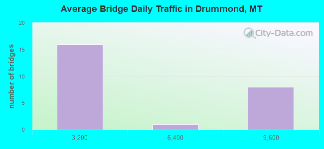
- 79,186Total average daily traffic
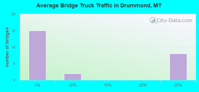
- 14,431Total average daily truck traffic
- National Bridge Inventory (NBI) Registered Bridges for Drummond
- No street view available for this location
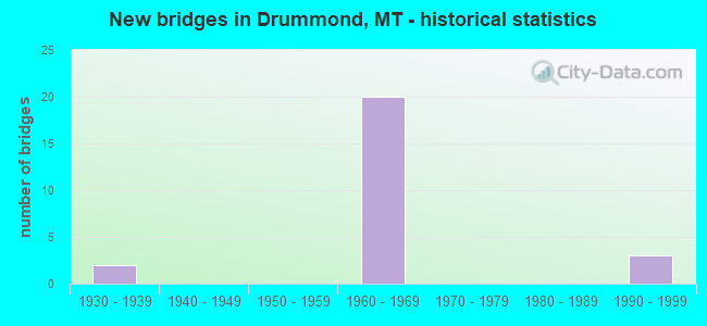
- New bridges - historical statistics
- 21930-1939
- 201960-1969
- 31990-1999
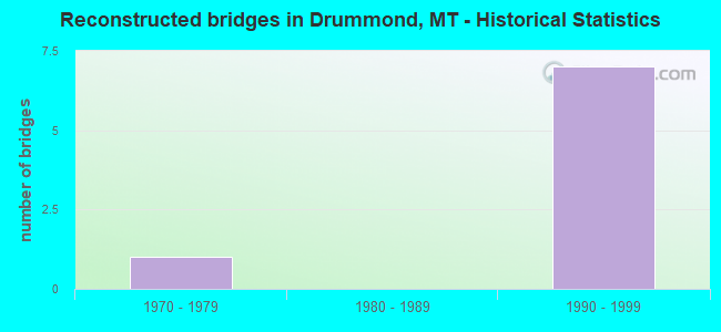
- Reconstructed bridges - Historical Statistics
- 11970-1979
- 01980-1989
- 71990-1999
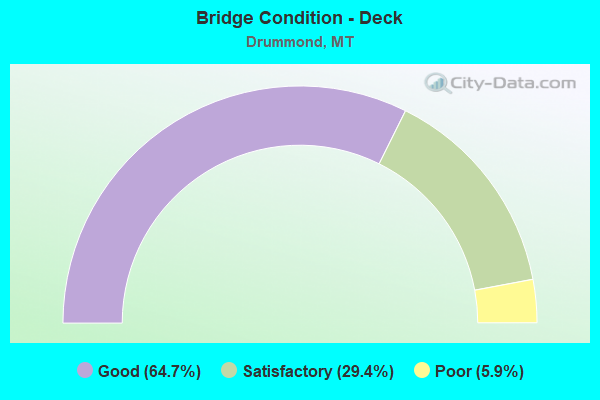
- Bridge Condition - Deck
- 64.7%Good
- 29.4%Satisfactory
- 5.9%Poor
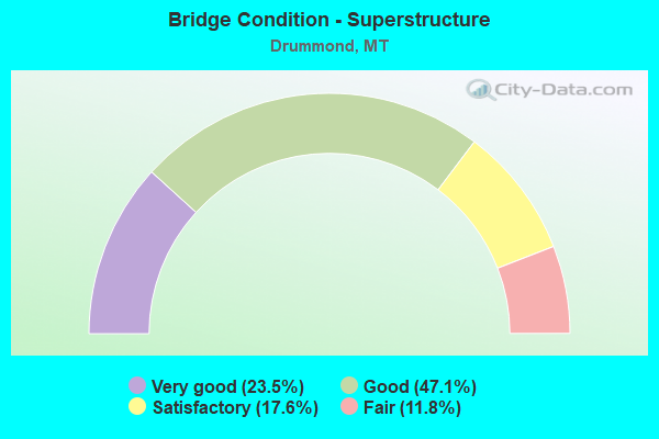
- Bridge Condition - Superstructure
- 23.5%Very good
- 47.1%Good
- 17.6%Satisfactory
- 11.8%Fair
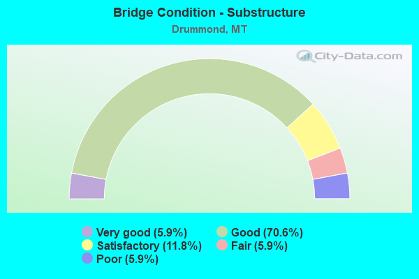
- Bridge Condition - Substructure
- 5.9%Very good
- 70.6%Good
- 11.8%Satisfactory
- 5.9%Fair
- 5.9%Poor
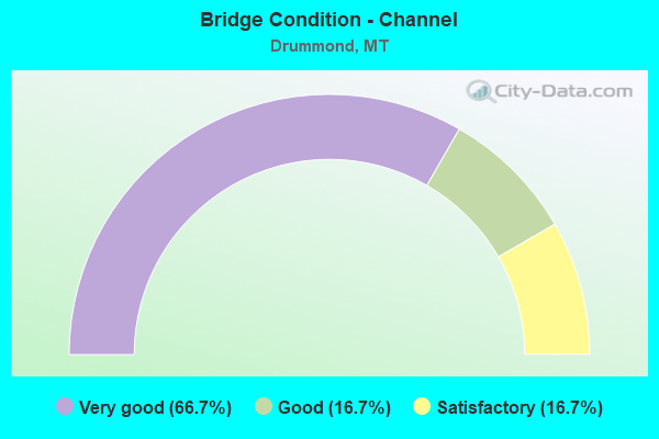
- Bridge Condition - Channel
- 66.7%Very good
- 16.7%Good
- 16.7%Satisfactory
Find on map >> Show street view
Structure Number: I00090153+03561, Location: DRUMMOND (Lat: 46.672000, Lng: -113.153694), Route carried "on" structure: Interstate 90, Year Built: 1966, Year Reconstructed: 2003, Status: Open, Structure Length: 3.81m (12.50ft), Average Daily Traffic: 8,044 (year 2020), Truck Traffic: 22%, Average Future Daily Traffic: 8,446 (year 2040), Design Load: HS 20, Features Intersected: INT W DRUMMOND
Minimum Vertical Clearance: 30+ m (98+ ft), Kilometerpoint: 245.791, Lanes on structure: 2, Lanes under structure: 2, Base Highway Network: Yes, Owner: State Highway Agency, Approaching Roadway Width: 11.6m (38.1ft), Material/Design: Prestressed concrete, Design/Construction: Stringer/Multi-beam, Number Of Spans In Main Unit: 3, Length of Maximum Span: 14.0m (45.9ft), Curb-To-Curb Width: 11.1m (36.4ft), Out-to-Out Width: 11.8m (38.7ft)
Condition: Deck: Good, Superstructure: Satisfactory, Substructure: Good, Operating Rating: 48.1 metric tons, Method Used To Determine Operating Rating: Load and Resistance Factor (LRFR), Inventory Rating: 34.5 metric tons, Method Used To Determine Inventory Rating: Load and Resistance Factor (LRFR), Structural Evaluation: Equal to present minimum criteria, Deck Geometry: Somewhat better than minimum adequacy, Underclear: High priority of corrective action, Approach Roadway Alignment: Equal to present desirable criteria, Designated Inspection Frequency: Every 24 months, Inspection Date: May 2020, Deck Structure Type: Concrete Cast-file-Place, Wearing Surface/Protective System: Wearing Surface: Epoxy Overlay, Deck Protection: Epoxy Coated Reinforcing
Find on map >> Show street view
Structure Number: I00090153+03562, Location: DRUMMOND (Lat: 46.672097, Lng: -113.153686), Route carried "on" structure: Interstate 90, Year Built: 1966, Year Reconstructed: 2003, Status: Open, Structure Length: 3.81m (12.50ft), Average Daily Traffic: 8,044 (year 2020), Truck Traffic: 22%, Average Future Daily Traffic: 8,446 (year 2040), Design Load: HS 20, Features Intersected: INT W DRUMMOND
Minimum Vertical Clearance: 30+ m (98+ ft), Kilometerpoint: 245.833, Lanes on structure: 2, Lanes under structure: 2, Base Highway Network: Yes, Owner: State Highway Agency, Approaching Roadway Width: 11.6m (38.1ft), Skew: 30 degrees, Material/Design: Prestressed concrete, Design/Construction: Stringer/Multi-beam, Number Of Spans In Main Unit: 3, Length of Maximum Span: 14.0m (45.9ft), Curb-To-Curb Width: 11.1m (36.4ft), Out-to-Out Width: 11.8m (38.7ft)
Condition: Deck: Good, Superstructure: Satisfactory, Substructure: Good, Operating Rating: 48.1 metric tons, Method Used To Determine Operating Rating: Load and Resistance Factor (LRFR), Inventory Rating: 34.5 metric tons, Method Used To Determine Inventory Rating: Load and Resistance Factor (LRFR), Structural Evaluation: Equal to present minimum criteria, Deck Geometry: Somewhat better than minimum adequacy, Underclear: Meets minimum limits, Approach Roadway Alignment: Equal to present desirable criteria, Designated Inspection Frequency: Every 24 months, Inspection Date: May 2020, Deck Structure Type: Concrete Cast-file-Place, Wearing Surface/Protective System: Wearing Surface: Epoxy Overlay, Deck Protection: Epoxy Coated Reinforcing
Find on map >> Show street view
Structure Number: I00090153+07641, Location: DRUMMOND (Lat: 46.670403, Lng: -113.145819), Route carried "on" structure: Interstate 90, Year Built: 1966, Year Reconstructed: 2004, Status: Open, Structure Length: 3.90m (12.80ft), Average Daily Traffic: 8,044 (year 2020), Truck Traffic: 22%, Average Future Daily Traffic: 8,446 (year 2040), Design Load: HS 20, Features Intersected: SEP EDWARDS GULCH ROAD
Minimum Vertical Clearance: 30+ m (98+ ft), Kilometerpoint: 246.438, Lanes on structure: 2, Lanes under structure: 2, Base Highway Network: Yes, Owner: State Highway Agency, Approaching Roadway Width: 11.1m (36.4ft), Skew: 31 degrees, Material/Design: Prestressed concrete, Design/Construction: Stringer/Multi-beam, Number Of Spans In Main Unit: 3, Length of Maximum Span: 14.0m (45.9ft), Curb-To-Curb Width: 11.1m (36.4ft), Out-to-Out Width: 11.8m (38.7ft)
Condition: Deck: Good, Superstructure: Good, Substructure: Good, Operating Rating: 38.1 metric tons, Method Used To Determine Operating Rating: Assigned rating based on Load Factor Design (LFD) reported in metric tons, Inventory Rating: 32.7 metric tons, Method Used To Determine Inventory Rating: Assigned rating based on Load Factor Design (LFD) reported in metric tons, Structural Evaluation: Better than present minimum criteria, Deck Geometry: Somewhat better than minimum adequacy, Underclear: Meets minimum limits, Approach Roadway Alignment: Equal to present desirable criteria, Designated Inspection Frequency: Every 24 months, Inspection Date: May 2020, Deck Structure Type: Concrete Cast-file-Place, Wearing Surface/Protective System: Wearing Surface: Epoxy Overlay, Deck Protection: Epoxy Coated Reinforcing
Find on map >> Show street view
Structure Number: I00090153+07642, Location: DRUMMOND (Lat: 46.670492, Lng: -113.145739), Route carried "on" structure: Interstate 90, Year Built: 1966, Year Reconstructed: 2004, Status: Open, Structure Length: 3.96m (12.99ft), Average Daily Traffic: 8,044 (year 2020), Truck Traffic: 22%, Average Future Daily Traffic: 8,446 (year 2040), Design Load: HS 20, Features Intersected: SEP EDWARDS GULCH ROAD
Minimum Vertical Clearance: 30+ m (98+ ft), Kilometerpoint: 246.485, Lanes on structure: 2, Lanes under structure: 2, Base Highway Network: Yes, Owner: State Highway Agency, Approaching Roadway Width: 11.4m (37.4ft), Skew: 31 degrees, Material/Design: Prestressed concrete, Design/Construction: Stringer/Multi-beam, Number Of Spans In Main Unit: 3, Length of Maximum Span: 13.7m (44.9ft), Curb-To-Curb Width: 11.1m (36.4ft), Out-to-Out Width: 11.8m (38.7ft)
Condition: Deck: Good, Superstructure: Very good, Substructure: Good, Operating Rating: 38.1 metric tons, Method Used To Determine Operating Rating: Assigned rating based on Load Factor Design (LFD) reported in metric tons, Inventory Rating: 32.7 metric tons, Method Used To Determine Inventory Rating: Assigned rating based on Load Factor Design (LFD) reported in metric tons, Structural Evaluation: Better than present minimum criteria, Deck Geometry: Somewhat better than minimum adequacy, Underclear: Meets minimum limits, Approach Roadway Alignment: Equal to present desirable criteria, Designated Inspection Frequency: Every 24 months, Inspection Date: May 2020, Deck Structure Type: Concrete Cast-file-Place, Wearing Surface/Protective System: Wearing Surface: Epoxy Overlay, Deck Protection: Epoxy Coated Reinforcing
Find on map >> Show street view
Structure Number: I00090154+02801, Location: DRUMMOND (Lat: 46.664939, Lng: -113.138397), Route carried "on" structure: Interstate 90, Year Built: 1966, Year Reconstructed: 2003, Status: Open, Structure Length: 4.11m (13.48ft), Average Daily Traffic: 8,044 (year 2020), Truck Traffic: 22%, Average Future Daily Traffic: 8,446 (year 2040), Design Load: HS 20, Features Intersected: INT E DRUMMOND
Minimum Vertical Clearance: 30+ m (98+ ft), Kilometerpoint: 247.275, Lanes on structure: 2, Lanes under structure: 2, Base Highway Network: Yes, Owner: State Highway Agency, Approaching Roadway Width: 11.6m (38.1ft), Skew: 11 degrees, Material/Design: Prestressed concrete, Design/Construction: Stringer/Multi-beam, Number Of Spans In Main Unit: 3, Length of Maximum Span: 15.5m (50.9ft), Curb-To-Curb Width: 11.4m (37.4ft), Out-to-Out Width: 11.9m (39.0ft)
Condition: Deck: Good, Superstructure: Fair, Substructure: Good, Operating Rating: 45.4 metric tons, Method Used To Determine Operating Rating: Load and Resistance Factor (LRFR), Inventory Rating: 32.7 metric tons, Method Used To Determine Inventory Rating: Load and Resistance Factor (LRFR), Structural Evaluation: Somewhat better than minimum adequacy, Deck Geometry: Somewhat better than minimum adequacy, Underclear: Meets minimum limits, Approach Roadway Alignment: Equal to present desirable criteria, Designated Inspection Frequency: Every 24 months, Inspection Date: May 2020, Deck Structure Type: Concrete Cast-file-Place, Wearing Surface/Protective System: Wearing Surface: Epoxy Overlay, Deck Protection: Epoxy Coated Reinforcing
Find on map >> Show street view
Structure Number: I00090154+02802, Location: DRUMMOND (Lat: 46.665106, Lng: -113.138222), Route carried "on" structure: Interstate 90, Year Built: 1966, Year Reconstructed: 2003, Status: Open, Structure Length: 4.11m (13.48ft), Average Daily Traffic: 8,342 (year 2020), Truck Traffic: 21%, Average Future Daily Traffic: 8,759 (year 2040), Design Load: HS 20, Features Intersected: INT E DRUMMOND
Minimum Vertical Clearance: 30+ m (98+ ft), Kilometerpoint: 247.322, Lanes on structure: 2, Lanes under structure: 2, Base Highway Network: Yes, Owner: State Highway Agency, Approaching Roadway Width: 11.6m (38.1ft), Skew: 11 degrees, Material/Design: Prestressed concrete, Design/Construction: Stringer/Multi-beam, Number Of Spans In Main Unit: 3, Length of Maximum Span: 15.5m (50.9ft), Curb-To-Curb Width: 11.2m (36.7ft), Out-to-Out Width: 12.0m (39.4ft)
Condition: Deck: Good, Superstructure: Good, Substructure: Good, Operating Rating: 45.4 metric tons, Method Used To Determine Operating Rating: Load and Resistance Factor (LRFR), Inventory Rating: 32.7 metric tons, Method Used To Determine Inventory Rating: Load and Resistance Factor (LRFR), Structural Evaluation: Better than present minimum criteria, Deck Geometry: Somewhat better than minimum adequacy, Underclear: Somewhat better than minimum adequacy, Approach Roadway Alignment: Equal to present desirable criteria, Designated Inspection Frequency: Every 24 months, Inspection Date: May 2020, Deck Structure Type: Concrete Cast-file-Place, Wearing Surface/Protective System: Wearing Surface: Epoxy Overlay, Deck Protection: Epoxy Coated Reinforcing
Find on map >> Show street view
Structure Number: I00090155+07871, Location: 1.2M E DRUMMOND (Lat: 46.647950, Lng: -113.118672), Route carried "on" structure: Interstate 90, Year Built: 1966, Status: Open, Structure Length: 3.96m (12.99ft), Average Daily Traffic: 8,342 (year 2020), Truck Traffic: 21%, Average Future Daily Traffic: 8,759 (year 2040), Design Load: HS 20, Features Intersected: SEP S-271
Minimum Vertical Clearance: 30+ m (98+ ft), Kilometerpoint: 249.694, Lanes on structure: 2, Lanes under structure: 2, Base Highway Network: Yes, Owner: State Highway Agency, Approaching Roadway Width: 11.6m (38.1ft), Skew: 1 degrees, Material/Design: Prestressed concrete, Design/Construction: Stringer/Multi-beam, Number Of Spans In Main Unit: 3, Length of Maximum Span: 14.0m (45.9ft), Curb-To-Curb Width: 11.4m (37.4ft), Out-to-Out Width: 11.9m (39.0ft)
Condition: Deck: Good, Superstructure: Very good, Substructure: Good, Operating Rating: 48.1 metric tons, Method Used To Determine Operating Rating: Load and Resistance Factor (LRFR), Inventory Rating: 31.8 metric tons, Method Used To Determine Inventory Rating: Load and Resistance Factor (LRFR), Structural Evaluation: Better than present minimum criteria, Deck Geometry: Somewhat better than minimum adequacy, Underclear: Meets minimum limits, Approach Roadway Alignment: Equal to present desirable criteria, Designated Inspection Frequency: Every 24 months, Inspection Date: May 2020, Deck Structure Type: Concrete Cast-file-Place, Wearing Surface/Protective System: Wearing Surface: Latex Concrete
Find on map >> Show street view
Structure Number: I00090155+07872, Location: 1.2M E DRUMMOND (Lat: 46.648042, Lng: -113.118383), Route carried "on" structure: Interstate 90, Year Built: 1966, Year Reconstructed: 2003, Status: Open, Structure Length: 3.96m (12.99ft), Average Daily Traffic: 8,342 (year 2020), Truck Traffic: 21%, Average Future Daily Traffic: 8,759 (year 2040), Design Load: HS 20, Features Intersected: SEP S-271
Minimum Vertical Clearance: 30+ m (98+ ft), Kilometerpoint: 249.753, Lanes on structure: 2, Lanes under structure: 2, Base Highway Network: Yes, Owner: State Highway Agency, Approaching Roadway Width: 11.6m (38.1ft), Material/Design: Prestressed concrete, Design/Construction: Stringer/Multi-beam, Number Of Spans In Main Unit: 3, Length of Maximum Span: 14.0m (45.9ft), Curb-To-Curb Width: 11.2m (36.7ft), Out-to-Out Width: 12.0m (39.4ft)
Condition: Deck: Good, Superstructure: Good, Substructure: Good, Operating Rating: 49.9 metric tons, Method Used To Determine Operating Rating: Load and Resistance Factor (LRFR), Inventory Rating: 35.4 metric tons, Method Used To Determine Inventory Rating: Load and Resistance Factor (LRFR), Structural Evaluation: Better than present minimum criteria, Deck Geometry: Somewhat better than minimum adequacy, Underclear: Meets minimum limits, Approach Roadway Alignment: Equal to present desirable criteria, Designated Inspection Frequency: Every 24 months, Inspection Date: May 2020, Deck Structure Type: Concrete Cast-file-Place, Wearing Surface/Protective System: Wearing Surface: Epoxy Overlay, Deck Protection: Epoxy Coated Reinforcing
Find on map >> Show street view
Structure Number: L20007000+08001, Location: 2M S DRUMMOND (Lat: 46.629172, Lng: -113.154750), Route carried "on" structure: Spur County highway 20006, Year Built: 1998, Status: Open, Structure Length: 1.49m (4.89ft), Average Daily Traffic: 100 (year 2022), Truck Traffic: 3%, Average Future Daily Traffic: 100 (year 2037), Design Load: HS 20, Features Intersected: FLINT CREEK OVERFLOW 084, Facility Carried by Structure: MULLAN RD E
Minimum Vertical Clearance: 30+ m (98+ ft), Kilometerpoint: 1.287, Lanes on structure: 2, Owner: County Highway Agency, Approaching Roadway Width: 7.3m (24.0ft), Material/Design: Prestressed concrete, Design/Construction: Tee Beam, Number Of Spans In Main Unit: 1, Length of Maximum Span: 13.5m (44.3ft), Curb-To-Curb Width: 7.2m (23.6ft), Out-to-Out Width: 7.9m (25.9ft)
Condition: Deck: Good, Superstructure: Very good, Substructure: Good, Channel: Very good, Operating Rating: 75.4 metric tons, Method Used To Determine Operating Rating: Load Factor (LF), Inventory Rating: 45.2 metric tons, Method Used To Determine Inventory Rating: Load Factor (LF), Structural Evaluation: Better than present minimum criteria, Deck Geometry: Somewhat better than minimum adequacy, Waterway Adequacy: Equal to present desirable criteria, Approach Roadway Alignment: Equal to present minimum criteria, Designated Inspection Frequency: Every 24 months, Inspection Date: July 2020, Deck Structure Type: Concrete Precast Panels
Find on map >> Show street view
Structure Number: L20007001+00001, Location: 2M S DRUMMOND (Lat: 46.628742, Lng: -113.151244), Route carried "on" structure: Spur County highway 20006, Year Built: 1998, Status: Open, Structure Length: 1.84m (6.04ft), Average Daily Traffic: 100 (year 2022), Truck Traffic: 3%, Average Future Daily Traffic: 100 (year 2037), Design Load: HS 20, Features Intersected: FLINT CREEK 001, Facility Carried by Structure: MULLAN RD E
Minimum Vertical Clearance: 30+ m (98+ ft), Kilometerpoint: 1.563, Lanes on structure: 2, Owner: County Highway Agency, Approaching Roadway Width: 5.5m (18.0ft), Material/Design: Prestressed concrete, Design/Construction: Tee Beam, Number Of Spans In Main Unit: 1, Length of Maximum Span: 17.0m (55.8ft), Curb-To-Curb Width: 7.2m (23.6ft), Out-to-Out Width: 7.9m (25.9ft)
Condition: Deck: Satisfactory, Superstructure: Good, Substructure: Good, Channel: Very good, Operating Rating: 67.1 metric tons, Method Used To Determine Operating Rating: Load Factor (LF), Inventory Rating: 40.2 metric tons, Method Used To Determine Inventory Rating: Load Factor (LF), Structural Evaluation: Better than present minimum criteria, Deck Geometry: Somewhat better than minimum adequacy, Waterway Adequacy: Equal to present desirable criteria, Approach Roadway Alignment: Equal to present minimum criteria, Designated Inspection Frequency: Every 24 months, Inspection Date: July 2020, Deck Structure Type: Concrete Precast Panels
Find on map >> Show street view
Structure Number: L20016000+05001, Location: S DRUMMOND (Lat: 46.662125, Lng: -113.150189), Route carried "on" structure: County highway 20016, Year Built: 1934, Status: Open, Structure Length: 8.14m (26.71ft), Average Daily Traffic: 519 (year 2020), Truck Traffic: 3%, Average Future Daily Traffic: 545 (year 2040), Design Load: H 15, Features Intersected: CLARK FORK RIVER 020, Facility Carried by Structure: S MAIN STREET
Minimum Vertical Clearance: 30+ m (98+ ft), Kilometerpoint: 0.080, Lanes on structure: 2, Owner: County Highway Agency, Approaching Roadway Width: 7.3m (24.0ft), Material/Design: Steel, Design/Construction: Stringer/Multi-beam, Number Of Spans In Main Unit: 4, Length of Maximum Span: 22.9m (75.1ft), Curb or Sidewalk Widths: Left: 0.5m (1.6ft), Right: 0.5m (1.6ft), Curb-To-Curb Width: 6.7m (22.0ft), Out-to-Out Width: 7.7m (25.3ft)
Condition: Deck: Poor, Superstructure: Fair, Substructure: Good, Channel: Good, Operating Rating: 35.3 metric tons, Method Used To Determine Operating Rating: Allowable Stress (AS), Inventory Rating: 21.7 metric tons, Method Used To Determine Inventory Rating: Allowable Stress (AS), Structural Evaluation: Somewhat better than minimum adequacy, Deck Geometry: Meets minimum limits, Waterway Adequacy: Equal to present desirable criteria, Approach Roadway Alignment: Equal to present desirable criteria, Designated Inspection Frequency: Every 24 months, Underwater Inspection Frequency: Every 60 months, Other Special Inspection Frequency: Every 48 months, Inspection Date: May 2020, Underwater Inspection Date: October 2018, Other Special Inspection Date: October 2020, Deck Structure Type: Concrete Cast-file-Place, Wearing Surface/Protective System: Wearing Surface: Bituminous, Membrane: Preformed Fabric
Find on map >> Show street view
Structure Number: M20035000+00101, Location: DRUMMOND-MAIN STREET (Lat: 46.666653, Lng: -113.147292), Route carried "on" structure: City street 20035, Year Built: 1934, Status: Posted for load, Structure Length: 0.79m (2.59ft), Average Daily Traffic: 500 (year 2020), Truck Traffic: 3%, Average Future Daily Traffic: 525 (year 2040), Design Load: H 15, Features Intersected: BERGMAN SLOUGH 019, Facility Carried by Structure: MAIN ST
Minimum Vertical Clearance: 30+ m (98+ ft), Kilometerpoint: 0.616, Lanes on structure: 2, Owner: County Highway Agency, Approaching Roadway Width: 7.0m (23.0ft), Material/Design: Wood or Timber, Design/Construction: Stringer/Multi-beam, Number Of Spans In Main Unit: 1, Length of Maximum Span: 7.6m (24.9ft), Curb or Sidewalk Widths: Left: 0.1m (0.3ft), Right: 0.1m (0.3ft), Curb-To-Curb Width: 6.5m (21.3ft), Out-to-Out Width: 6.7m (22.0ft)
Condition: Deck: Satisfactory, Superstructure: Good, Substructure: Good, Channel: Very good, Operating Rating: 42.6 metric tons, Method Used To Determine Operating Rating: Allowable Stress (AS), Inventory Rating: 29.9 metric tons, Method Used To Determine Inventory Rating: Allowable Stress (AS), Structural Evaluation: Better than present minimum criteria, Deck Geometry: High priority of corrective action, Waterway Adequacy: Equal to present desirable criteria, Approach Roadway Alignment: Equal to present desirable criteria, Bridge Posting: Required (Relationship of Operating Rating to Maximum Legal Load: 10.0 - 19.9% below), Designated Inspection Frequency: Every 24 months, Inspection Date: July 2020, Deck Structure Type: Wood or Timber, Wearing Surface/Protective System: Wearing Surface: Bituminous
Find on map >> Show street view
Structure Number: P00019000+00001, Location: 6M S WARM SPRINGS (Lat: 46.095586, Lng: -112.792939), Route carried "on" structure: Alternate State highway 1, Year Built: 1964, Status: Open, Structure Length: 8.41m (27.59ft), Average Daily Traffic: 3,774 (year 2020), Truck Traffic: 2%, Average Future Daily Traffic: 3,963 (year 2040), Design Load: HS 20, Features Intersected: INT I 90
Minimum Vertical Clearance: 30+ m (98+ ft), Kilometerpoint: 0.000, Lanes on structure: 2, Lanes under structure: 4, Base Highway Network: Yes, Owner: State Highway Agency, Approaching Roadway Width: 12.2m (40.0ft), Skew: 22 degrees, Material/Design: Prestressed concrete, Design/Construction: Stringer/Multi-beam, Number Of Spans In Main Unit: 5, Length of Maximum Span: 17.2m (56.4ft), Curb-To-Curb Width: 11.6m (38.1ft), Out-to-Out Width: 12.4m (40.7ft)
Condition: Deck: Satisfactory, Superstructure: Good, Substructure: Satisfactory, Operating Rating: 56.9 metric tons, Method Used To Determine Operating Rating: Load Factor (LF), Inventory Rating: 39.6 metric tons, Method Used To Determine Inventory Rating: Load Factor (LF), Structural Evaluation: Equal to present minimum criteria, Deck Geometry: Somewhat better than minimum adequacy, Underclear: High priority of corrective action, Approach Roadway Alignment: Better than present minimum criteria, Designated Inspection Frequency: Every 24 months, Inspection Date: June 2020, Deck Structure Type: Concrete Cast-file-Place
Find on map >> Show street view
Structure Number: P00019059+07341, Location: 4M S DRUMMOND (Lat: 46.613769, Lng: -113.177656), Route carried "on" structure: Alternate State highway 1, Year Built: 1999, Status: Open, Structure Length: 2.03m (6.66ft), Average Daily Traffic: 1,467 (year 2020), Truck Traffic: 2%, Average Future Daily Traffic: 1,606 (year 2040), Design Load: HS 20, Features Intersected: WILLOW CREEK
Minimum Vertical Clearance: 30+ m (98+ ft), Kilometerpoint: 95.563, Lanes on structure: 2, Base Highway Network: Yes, Owner: State Highway Agency, Approaching Roadway Width: 11.0m (36.1ft), Skew: 1 degrees, Material/Design: Prestressed concrete, Design/Construction: Stringer/Multi-beam, Number Of Spans In Main Unit: 1, Length of Maximum Span: 18.9m (62.0ft), Curb-To-Curb Width: 11.0m (36.1ft), Out-to-Out Width: 11.7m (38.4ft)
Condition: Deck: Satisfactory, Superstructure: Very good, Substructure: Very good, Channel: Very good, Operating Rating: 32.7 metric tons, Method Used To Determine Operating Rating: Assigned rating based on Load Factor Design (LFD) reported in metric tons, Inventory Rating: 32.7 metric tons, Method Used To Determine Inventory Rating: Assigned rating based on Load Factor Design (LFD) reported in metric tons, Structural Evaluation: Equal to present desirable criteria, Deck Geometry: Equal to present minimum criteria, Waterway Adequacy: Equal to present desirable criteria, Approach Roadway Alignment: Equal to present desirable criteria, Designated Inspection Frequency: Every 48 months, Inspection Date: July 2020, Deck Structure Type: Concrete Cast-file-Place, Wearing Surface/Protective System: Deck Protection: Epoxy Coated Reinforcing
Find on map >> Show street view
Structure Number: P00019063+02511, Location: DRUMMOND (Lat: 46.661561, Lng: -113.157114), Route carried "on" structure: Alternate State highway 1, Year Built: 1966, Status: Open, Structure Length: 9.17m (30.09ft), Average Daily Traffic: 1,256 (year 2020), Truck Traffic: 2%, Average Future Daily Traffic: 1,375 (year 2040), Design Load: HS 20, Features Intersected: CLARK FORK
Minimum Vertical Clearance: 30+ m (98+ ft), Kilometerpoint: 101.154, Lanes on structure: 2, Base Highway Network: Yes, Owner: State Highway Agency, Approaching Roadway Width: 12.8m (42.0ft), Material/Design: Prestressed concrete, Design/Construction: Stringer/Multi-beam, Number Of Spans In Main Unit: 5, Length of Maximum Span: 18.6m (61.0ft), Curb-To-Curb Width: 8.5m (27.9ft), Out-to-Out Width: 9.7m (31.8ft)
Condition: Deck: Satisfactory, Superstructure: Satisfactory, Substructure: Poor, Channel: Satisfactory, Operating Rating: 51.7 metric tons, Method Used To Determine Operating Rating: Load and Resistance Factor (LRFR), Inventory Rating: 37.2 metric tons, Method Used To Determine Inventory Rating: Load and Resistance Factor (LRFR), Structural Evaluation: Meets minimum limits, Deck Geometry: Somewhat better than minimum adequacy, Waterway Adequacy: Superior to present desirable criteria, Approach Roadway Alignment: Equal to present desirable criteria, Designated Inspection Frequency: Every 24 months, Underwater Inspection Frequency: Every 60 months, Inspection Date: May 2020, Underwater Inspection Date: September 2020, Deck Structure Type: Concrete Cast-file-Place, Wearing Surface/Protective System: Wearing Surface: Latex Concrete
Find on map >> Show street view
Structure Number: P00019063+04351, Location: DRUMMOND (Lat: 46.664886, Lng: -113.155650), Route carried "on" structure: Alternate State highway 1, Year Built: 1966, Status: Open, Structure Length: 5.03m (16.50ft), Average Daily Traffic: 1,256 (year 2020), Truck Traffic: 2%, Average Future Daily Traffic: 1,375 (year 2040), Design Load: HS 20, Features Intersected: ABANDONED RAILROAD
Minimum Vertical Clearance: 30+ m (98+ ft), Kilometerpoint: 101.537, Lanes on structure: 2, Base Highway Network: Yes, Owner: State Highway Agency, Approaching Roadway Width: 9.1m (29.9ft), Material/Design: Prestressed concrete, Design/Construction: Stringer/Multi-beam, Number Of Spans In Main Unit: 3, Length of Maximum Span: 18.9m (62.0ft), Curb-To-Curb Width: 8.5m (27.9ft), Out-to-Out Width: 9.4m (30.8ft)
Condition: Deck: Good, Superstructure: Good, Substructure: Fair, Operating Rating: 47.2 metric tons, Method Used To Determine Operating Rating: Load and Resistance Factor (LRFR), Inventory Rating: 32.7 metric tons, Method Used To Determine Inventory Rating: Load and Resistance Factor (LRFR), Structural Evaluation: Somewhat better than minimum adequacy, Deck Geometry: Somewhat better than minimum adequacy, Underclear: Better than present minimum criteria, Approach Roadway Alignment: Equal to present desirable criteria, Designated Inspection Frequency: Every 24 months, Inspection Date: July 2020, Deck Structure Type: Concrete Cast-file-Place, Wearing Surface/Protective System: Wearing Surface: Latex Concrete
Find on map >> Show street view
Structure Number: P00019063+08231, Location: DRUMMOND (Lat: 46.669506, Lng: -113.153772), Route carried "on" structure: Alternate State highway 1, Year Built: 1966, Year Reconstructed: 1983, Status: Open, Structure Length: 5.79m (19.00ft), Average Daily Traffic: 1,256 (year 2020), Truck Traffic: 2%, Average Future Daily Traffic: 1,375 (year 2040), Design Load: HS 20, Features Intersected: RR
Minimum Vertical Clearance: 30+ m (98+ ft), Kilometerpoint: 102.074, Lanes on structure: 2, Base Highway Network: Yes, Owner: State Highway Agency, Approaching Roadway Width: 9.8m (32.2ft), Skew: 1 degrees, Material/Design: Prestressed concrete, Design/Construction: Stringer/Multi-beam, Number Of Spans In Main Unit: 3, Length of Maximum Span: 21.9m (71.9ft), Curb-To-Curb Width: 8.5m (27.9ft), Out-to-Out Width: 9.4m (30.8ft)
Condition: Deck: Good, Superstructure: Good, Substructure: Satisfactory, Operating Rating: 51.7 metric tons, Method Used To Determine Operating Rating: Load and Resistance Factor (LRFR), Inventory Rating: 35.4 metric tons, Method Used To Determine Inventory Rating: Load and Resistance Factor (LRFR), Structural Evaluation: Equal to present minimum criteria, Deck Geometry: Somewhat better than minimum adequacy, Underclear: Equal to present minimum criteria, Approach Roadway Alignment: Equal to present desirable criteria, Designated Inspection Frequency: Every 24 months, Inspection Date: July 2020, Deck Structure Type: Concrete Cast-file-Place, Wearing Surface/Protective System: Wearing Surface: Latex Concrete
Find on map >> Show street view
Structure Number: I00090153+03561, Location: DRUMMOND (Lat: 46.672000, Lng: -113.153694), Route carried "under" structure: Alternate State highway 1, Year Built: 1966, Structure Length: 0. m, Average Daily Traffic: 1,310 (year 2020), Truck Traffic: 3%, Features Intersected: INT W DRUMMOND, Facility Carried by Structure: I 90
Minimum Vertical Clearance: 4.57m (14.99ft), Kilometerpoint: 0.001, Lanes on structure: 2, Lanes under structure: 2, Material/Design: Prestressed concrete, Design/Construction: Stringer/Multi-beam, Length of Maximum Span: 14.0m (45.9ft)
Find on map >> Show street view
Structure Number: I00090153+03562, Location: DRUMMOND (Lat: 46.672097, Lng: -113.153686), Route carried "under" structure: ServiceState highway 1, Year Built: 1966, Structure Length: 0. m, Average Daily Traffic: 1,310 (year 2020), Truck Traffic: 3%, Features Intersected: INT W DRUMMOND, Facility Carried by Structure: I 90
Minimum Vertical Clearance: 4.69m (15.39ft), Kilometerpoint: 0.012, Lanes on structure: 2, Lanes under structure: 2, Material/Design: Prestressed concrete, Design/Construction: Stringer/Multi-beam, Length of Maximum Span: 14.0m (45.9ft)
Find on map >> Show street view
Structure Number: I00090153+07641, Location: DRUMMOND (Lat: 46.670403, Lng: -113.145819), Route carried "under" structure: ServiceState highway 20000, Year Built: 1966, Structure Length: 0. m, Average Daily Traffic: 274 (year 2020), Truck Traffic: 3%, Features Intersected: SEP EDWARDS GULCH ROAD, Facility Carried by Structure: I 90
Minimum Vertical Clearance: 5.38m (17.65ft), Kilometerpoint: 0.332, Lanes on structure: 2, Lanes under structure: 2, Material/Design: Prestressed concrete, Design/Construction: Stringer/Multi-beam, Length of Maximum Span: 14.0m (45.9ft)
Find on map >> Show street view
Structure Number: I00090153+07642, Location: DRUMMOND (Lat: 46.670492, Lng: -113.145739), Route carried "under" structure: ServiceState highway 20000, Year Built: 1966, Structure Length: 0. m, Average Daily Traffic: 274 (year 2020), Truck Traffic: 3%, Features Intersected: SEP EDWARDS GULCH ROAD, Facility Carried by Structure: I 90
Minimum Vertical Clearance: 5.38m (17.65ft), Kilometerpoint: 0.344, Lanes on structure: 2, Lanes under structure: 2, Material/Design: Prestressed concrete, Design/Construction: Stringer/Multi-beam, Length of Maximum Span: 13.7m (44.9ft)
Find on map >> Show street view
Structure Number: I00090154+02801, Location: DRUMMOND (Lat: 46.664939, Lng: -113.138397), Route carried "under" structure: State highway 96, Year Built: 1966, Structure Length: 0. m, Average Daily Traffic: 48 (year 2020), Truck Traffic: 3%, Features Intersected: INT E DRUMMOND, Facility Carried by Structure: I 90
Minimum Vertical Clearance: 4.62m (15.16ft), Kilometerpoint: 0.002, Lanes on structure: 2, Lanes under structure: 2, Material/Design: Prestressed concrete, Design/Construction: Stringer/Multi-beam, Length of Maximum Span: 15.5m (50.9ft)
Find on map >> Show street view
Structure Number: I00090154+02802, Location: DRUMMOND (Lat: 46.665106, Lng: -113.138222), Route carried "under" structure: US 88, Year Built: 1966, Structure Length: 0. m, Average Daily Traffic: 48 (year 2020), Truck Traffic: 3%, Features Intersected: INT E DRUMMOND, Facility Carried by Structure: I 90
Minimum Vertical Clearance: 4.89m (16.04ft), Kilometerpoint: 0.025, Lanes on structure: 2, Lanes under structure: 2, Material/Design: Prestressed concrete, Design/Construction: Stringer/Multi-beam, Length of Maximum Span: 15.5m (50.9ft)
Find on map >> Show street view
Structure Number: I00090155+07871, Location: 12M E DRUMMOND (Lat: 46.647950, Lng: -113.118672), Route carried "under" structure: State highway 271, Year Built: 1966, Structure Length: 0. m, Average Daily Traffic: 224 (year 2020), Truck Traffic: 5%, Features Intersected: SEP S-271, Facility Carried by Structure: I 90
Minimum Vertical Clearance: 5.36m (17.59ft), Kilometerpoint: 2.429, Lanes on structure: 2, Lanes under structure: 2, Material/Design: Prestressed concrete, Design/Construction: Stringer/Multi-beam, Length of Maximum Span: 14.0m (45.9ft)
Find on map >> Show street view
Structure Number: I00090155+07872, Location: 12M E DRUMMOND (Lat: 46.648042, Lng: -113.118383), Route carried "under" structure: State highway 271, Year Built: 1966, Structure Length: 0. m, Average Daily Traffic: 224 (year 2020), Truck Traffic: 5%, Features Intersected: SEP S-271, Facility Carried by Structure: I 90
Minimum Vertical Clearance: 4.77m (15.65ft), Kilometerpoint: 2.453, Lanes on structure: 2, Lanes under structure: 2, Material/Design: Prestressed concrete, Design/Construction: Stringer/Multi-beam, Length of Maximum Span: 14.0m (45.9ft)