Bridge Statistics for Dudley, Massachusetts (MA)
Condition, Traffic, Stress, Structural Evaluation, Project Costs
- National Bridge Inventory (NBI) Statistics
- 12Number of bridges
- 98ft / 30.3mTotal length
- $26,333,000Total costs
- 37,915Total average daily traffic
- 2,425Total average daily truck traffic
- 81,869Total future (year 2032) average daily traffic
- National Bridge Inventory (NBI) Registered Bridges for Dudley
- No street view available for this location
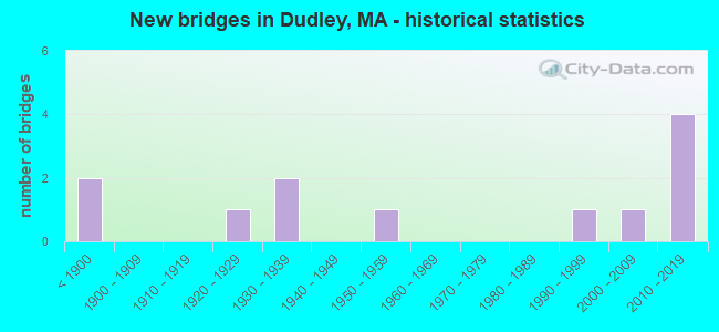
- New bridges - historical statistics
- 2Before 1900
- 11920-1929
- 21930-1939
- 11950-1959
- 11990-1999
- 12000-2009
- 42010-2019
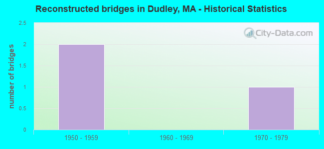
- Reconstructed bridges - Historical Statistics
- 21950-1959
- 01960-1969
- 11970-1979
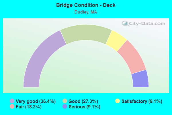
- Bridge Condition - Deck
- 36.4%Very good
- 27.3%Good
- 9.1%Satisfactory
- 18.2%Fair
- 9.1%Serious
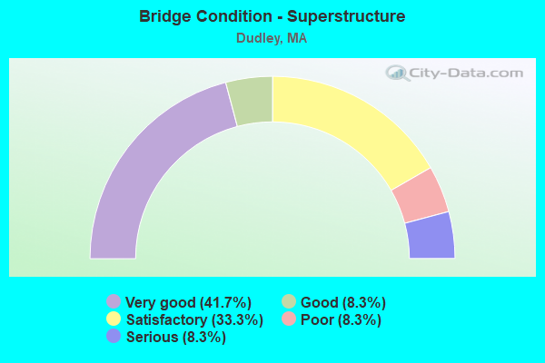
- Bridge Condition - Superstructure
- 41.7%Very good
- 8.3%Good
- 33.3%Satisfactory
- 8.3%Poor
- 8.3%Serious
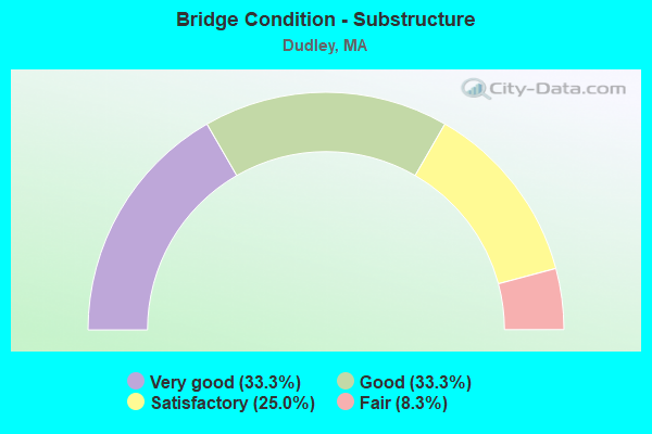
- Bridge Condition - Substructure
- 33.3%Very good
- 33.3%Good
- 25.0%Satisfactory
- 8.3%Fair
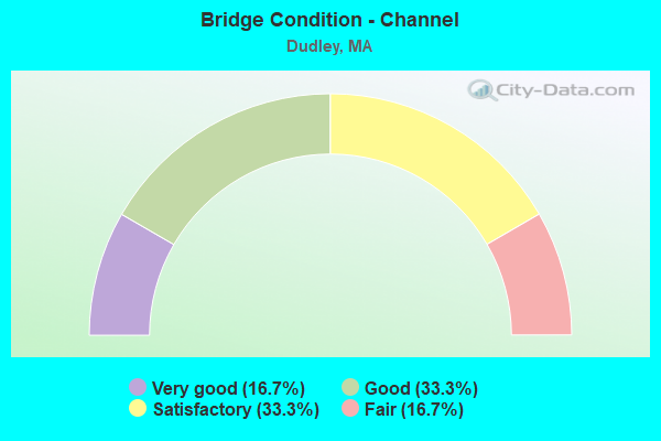
- Bridge Condition - Channel
- 16.7%Very good
- 33.3%Good
- 33.3%Satisfactory
- 16.7%Fair
Find on map >> Show street view
Structure Number: D1200192CMUNNBI, Location: .2 MI E OF ST-12 (Lat: 42.024717, Lng: -71.884006), Route carried "on" structure: City street , Year Built: 2011, Status: Open, Structure Length: 2.77m (9.09ft), Average Daily Traffic: 723 (year 2019), Truck Traffic: 5%, Design Load: HS 25 or greater, Features Intersected: WATER FRENCH RIVER, Facility Carried by Structure: HWY PERRYVLLE RD
Minimum Vertical Clearance: 30+ m (98+ ft), Kilometerpoint: 0.354, Lanes on structure: 2, Owner: Town or Township Highway Agency, Approaching Roadway Width: 8.0m (26.2ft), Material/Design: Prestressed concrete, Design/Construction: Box Beam or Girders - Single/Spread, Number Of Spans In Main Unit: 1, Length of Maximum Span: 26.0m (85.3ft), Curb or Sidewalk Widths: Left: 0.0m, Right: 1.7m (5.6ft), Curb-To-Curb Width: 8.0m (26.2ft), Out-to-Out Width: 10.6m (34.8ft)
Condition: Deck: Very good, Superstructure: Very good, Substructure: Very good, Channel: Very good, Operating Rating: 92.7 metric tons, Method Used To Determine Operating Rating: Load Factor (LF), Inventory Rating: 66.1 metric tons, Method Used To Determine Inventory Rating: Load Factor (LF), Structural Evaluation: Equal to present desirable criteria, Deck Geometry: Somewhat better than minimum adequacy, Waterway Adequacy: Equal to present desirable criteria, Approach Roadway Alignment: Better than present minimum criteria, Length Of Structure Improvement: 2.80m (9.19ft), Designated Inspection Frequency: Every 24 months, Inspection Date: Febuary 2021, Bridge Improvement Cost: $1,109,000, Roadway Improvement Cost: $111,000, Total Project Cost: $1,664,000 ( Estimate for 2022), Deck Structure Type: Concrete Cast-file-Place, Wearing Surface/Protective System: Wearing Surface: Bituminous, Membrane: Built-up, Deck Protection: Epoxy Coated Reinforcing
Find on map >> Show street view
Structure Number: D1200290KMUNNBI, Location: .1 MI EAST OF ST12 (Lat: 42.024894, Lng: -71.885753), Route carried "on" structure: City street , Year Built: 2010, Status: Open, Structure Length: 2.25m (7.38ft), Average Daily Traffic: 723 (year 2019), Truck Traffic: 1%, Design Load: HS 25 or greater, Features Intersected: WATER CANAL, Facility Carried by Structure: HWY PERRYVLLE RD
Minimum Vertical Clearance: 30+ m (98+ ft), Kilometerpoint: 0.145, Lanes on structure: 2, Owner: Town or Township Highway Agency, Approaching Roadway Width: 7.2m (23.6ft), Skew: 3 degrees, Material/Design: Prestressed concrete, Design/Construction: Box Beam or Girders - Single/Spread, Number Of Spans In Main Unit: 1, Length of Maximum Span: 21.0m (68.9ft), Curb or Sidewalk Widths: Left: 0.0m, Right: 1.5m (4.9ft), Curb-To-Curb Width: 7.2m (23.6ft), Out-to-Out Width: 9.6m (31.5ft)
Condition: Deck: Very good, Superstructure: Very good, Substructure: Very good, Channel: Fair, Operating Rating: 93.6 metric tons, Method Used To Determine Operating Rating: Load Factor (LF), Inventory Rating: 56.1 metric tons, Method Used To Determine Inventory Rating: Load Factor (LF), Structural Evaluation: Equal to present desirable criteria, Deck Geometry: Meets minimum limits, Waterway Adequacy: Better than present minimum criteria, Approach Roadway Alignment: Better than present minimum criteria, Length Of Structure Improvement: 2.30m (7.55ft), Designated Inspection Frequency: Every 24 months, Inspection Date: March 2021, Bridge Improvement Cost: $1,085,000, Roadway Improvement Cost: $109,000, Total Project Cost: $1,628,000 ( Estimate for 2022), Deck Structure Type: Concrete Cast-file-Place, Wearing Surface/Protective System: Wearing Surface: Bituminous, Membrane: Preformed Fabric, Deck Protection: Epoxy Coated Reinforcing
Find on map >> Show street view
Structure Number: D1200390JMUNNBI, Location: E. OF RT 12 AT CT. BORDER (Lat: 42.025192, Lng: -71.885500), Route carried "on" structure: City street , Year Built: 2010, Status: Open, Structure Length: 1.77m (5.81ft), Average Daily Traffic: 100 (year 2019), Truck Traffic: 1%, Design Load: HS 25 or greater, Features Intersected: WATER CANAL, Facility Carried by Structure: HWY UPPER PERRVL
Minimum Vertical Clearance: 30+ m (98+ ft), Kilometerpoint: 1.400, Lanes on structure: 2, Owner: Town or Township Highway Agency, Approaching Roadway Width: 6.0m (19.7ft), Skew: 2 degrees, Material/Design: Prestressed concrete, Design/Construction: Box Beam or Girders - Single/Spread, Number Of Spans In Main Unit: 1, Length of Maximum Span: 16.0m (52.5ft), Curb-To-Curb Width: 6.0m (19.7ft), Out-to-Out Width: 7.0m (23.0ft)
Condition: Deck: Very good, Superstructure: Very good, Substructure: Very good, Channel: Good, Operating Rating: 86.3 metric tons, Method Used To Determine Operating Rating: Load Factor (LF), Inventory Rating: 51.7 metric tons, Method Used To Determine Inventory Rating: Load Factor (LF), Structural Evaluation: Equal to present desirable criteria, Deck Geometry: Meets minimum limits, Waterway Adequacy: Better than present minimum criteria, Approach Roadway Alignment: Equal to present minimum criteria, Length Of Structure Improvement: 1.80m (5.91ft), Designated Inspection Frequency: Every 24 months, Inspection Date: March 2021, Bridge Improvement Cost: $645,000, Roadway Improvement Cost: $65,000, Total Project Cost: $968,000 ( Estimate for 2022), Deck Structure Type: Concrete Cast-file-Place, Wearing Surface/Protective System: Wearing Surface: Bituminous, Membrane: Preformed Fabric, Deck Protection: Epoxy Coated Reinforcing
Find on map >> Show street view
Structure Number: D120041BGMUNNBI, Location: .1 MILE EAST OF CHASE AVE (Lat: 42.043167, Lng: -71.887369), Route carried "on" structure: City street , Year Built: 1925, Status: Open, Structure Length: 1.40m (4.59ft), Average Daily Traffic: 1,875 (year 2020), Truck Traffic: 6%, Average Future Daily Traffic: 2,843 (year 2032), Features Intersected: WATER FRENCH RIVER, Facility Carried by Structure: HWY BRANDON RD
Minimum Vertical Clearance: 30+ m (98+ ft), Kilometerpoint: 1.161, Lanes on structure: 2, Owner: Town or Township Highway Agency, Approaching Roadway Width: 5.6m (18.4ft), Material/Design: Concrete, Design/Construction: Tee Beam, Number Of Spans In Main Unit: 1, Length of Maximum Span: 12.8m (42.0ft), Curb or Sidewalk Widths: Left: 0.3m (1.0ft), Right: 0.3m (1.0ft), Curb-To-Curb Width: 5.6m (18.4ft), Out-to-Out Width: 6.2m (20.3ft)
Condition: Deck: Satisfactory, Superstructure: Satisfactory, Substructure: Fair, Channel: Satisfactory, Operating Rating: 50.8 metric tons, Method Used To Determine Operating Rating: Allowable Stress (AS), Inventory Rating: 24.3 metric tons, Method Used To Determine Inventory Rating: Allowable Stress (AS), Structural Evaluation: Somewhat better than minimum adequacy, Deck Geometry: High priority of replacement, Waterway Adequacy: Equal to present desirable criteria, Approach Roadway Alignment: Better than present minimum criteria, Length Of Structure Improvement: 1.50m (4.92ft), Designated Inspection Frequency: Every 24 months, Inspection Date: June 2021, Bridge Improvement Cost: $366,000, Roadway Improvement Cost: $37,000, Total Project Cost: $550,000 ( Estimate for 2022), Deck Structure Type: Concrete Cast-file-Place, Wearing Surface/Protective System: Wearing Surface: Bituminous
Find on map >> Show street view
Structure Number: D120051BEMUNNBI, Location: .25 MI S OF RTE 12 (Lat: 42.046631, Lng: -71.887069), Route carried "on" structure: City street , Year Built: 1956, Status: Open, Structure Length: 2.62m (8.60ft), Average Daily Traffic: 2,500 (year 2018), Truck Traffic: 6%, Average Future Daily Traffic: 3,948 (year 2031), Design Load: H 20, Features Intersected: WATER FRENCH RIVER, Facility Carried by Structure: HWY CHASE AVE
Minimum Vertical Clearance: 30+ m (98+ ft), Kilometerpoint: 0.772, Lanes on structure: 2, Owner: Town or Township Highway Agency, Approaching Roadway Width: 8.8m (28.9ft), Skew: 1 degrees, Material/Design: Steel, Design/Construction: Stringer/Multi-beam, Number Of Spans In Main Unit: 1, Length of Maximum Span: 25.3m (83.0ft), Curb or Sidewalk Widths: Left: 1.8m (5.9ft), Right: 1.8m (5.9ft), Curb-To-Curb Width: 9.1m (29.9ft), Out-to-Out Width: 13.6m (44.6ft)
Condition: Deck: Fair, Superstructure: Satisfactory, Substructure: Satisfactory, Channel: Good, Operating Rating: 62.7 metric tons, Method Used To Determine Operating Rating: Load Factor (LF), Inventory Rating: 37.6 metric tons, Method Used To Determine Inventory Rating: Load Factor (LF), Structural Evaluation: Equal to present minimum criteria, Deck Geometry: Meets minimum limits, Waterway Adequacy: Equal to present desirable criteria, Approach Roadway Alignment: Equal to present desirable criteria, Length Of Structure Improvement: 2.70m (8.86ft), Designated Inspection Frequency: Every 24 months, Underwater Inspection Frequency: Every 36 months, Inspection Date: June 2020, Underwater Inspection Date: Febuary 2021, Bridge Improvement Cost: $2,249,000, Roadway Improvement Cost: $225,000, Total Project Cost: $3,374,000 ( Estimate for 2022), Deck Structure Type: Concrete Cast-file-Place, Wearing Surface/Protective System: Wearing Surface: Monolithic Concrete
Find on map >> Show street view
Structure Number: D120061YRDOTNBI, Location: AT WEBSTER-DUDLEY T.L. (Lat: 42.049264, Lng: -71.887439), Route carried "on" structure: State highway 12, Year Built: 1868, Year Reconstructed: 1956, Status: Open, Structure Length: 1.77m (5.81ft), Average Daily Traffic: 11,288 (year 2020), Truck Traffic: 12%, Average Future Daily Traffic: 31,586 (year 2032), Design Load: H 20, Features Intersected: WATER FRENCH RIVER
Minimum Vertical Clearance: 30+ m (98+ ft), Kilometerpoint: 2.953, Lanes on structure: 2, Owner: State Highway Agency, Approaching Roadway Width: 12.2m (40.0ft), Material/Design: Masonry, Design/Construction: Arch - Deck, Number Of Spans In Main Unit: 1, Length of Maximum Span: 12.8m (42.0ft), Curb or Sidewalk Widths: Left: 2.9m (9.5ft), Right: 1.5m (4.9ft), Curb-To-Curb Width: 12.4m (40.7ft), Out-to-Out Width: 16.8m (55.1ft)
Condition: Superstructure: Satisfactory, Substructure: Satisfactory, Channel: Fair, Inventory Rating: 68.4 metric tons, Method Used To Determine Inventory Rating: Allowable Stress (AS), Structural Evaluation: Equal to present minimum criteria, Deck Geometry: Somewhat better than minimum adequacy, Waterway Adequacy: Equal to present desirable criteria, Approach Roadway Alignment: Equal to present desirable criteria, Length Of Structure Improvement: 1.80m (5.91ft), Designated Inspection Frequency: Every 24 months, Underwater Inspection Frequency: Every 36 months, Inspection Date: June 2021, Underwater Inspection Date: December 2019, Bridge Improvement Cost: $170,000, Roadway Improvement Cost: $18,000, Total Project Cost: $256,000 ( Estimate for 2022)
Find on map >> Show street view
Structure Number: D12007AJTMUNNBI, Location: .1 MILE NO. OF ST - 12 (Lat: 42.050814, Lng: -71.885019), Route carried "on" structure: City street , Year Built: 2000, Status: Open, Structure Length: 2.60m (8.53ft), Average Daily Traffic: 3,418 (year 2015), Truck Traffic: 3%, Average Future Daily Traffic: 3,474 (year 2032), Design Load: HS 20, Features Intersected: WATER FRENCH RIVER, Facility Carried by Structure: HWY OXFORD AVE
Minimum Vertical Clearance: 30+ m (98+ ft), Kilometerpoint: 0.177, Lanes on structure: 2, Owner: Town or Township Highway Agency, Approaching Roadway Width: 8.5m (27.9ft), Material/Design: Steel, Design/Construction: Stringer/Multi-beam, Number Of Spans In Main Unit: 1, Length of Maximum Span: 25.0m (82.0ft), Curb or Sidewalk Widths: Left: 1.7m (5.6ft), Right: 1.7m (5.6ft), Curb-To-Curb Width: 8.5m (27.9ft), Out-to-Out Width: 12.8m (42.0ft)
Condition: Deck: Good, Superstructure: Very good, Substructure: Very good, Channel: Satisfactory, Operating Rating: 70.7 metric tons, Method Used To Determine Operating Rating: Load Factor (LF), Inventory Rating: 40.5 metric tons, Method Used To Determine Inventory Rating: Load Factor (LF), Structural Evaluation: Equal to present desirable criteria, Deck Geometry: Meets minimum limits, Waterway Adequacy: Equal to present desirable criteria, Approach Roadway Alignment: Better than present minimum criteria, Length Of Structure Improvement: 2.70m (8.86ft), Designated Inspection Frequency: Every 24 months, Inspection Date: May 2021, Bridge Improvement Cost: $1,248,000, Roadway Improvement Cost: $125,000, Total Project Cost: $1,873,000 ( Estimate for 2022), Deck Structure Type: Concrete Cast-file-Place, Wearing Surface/Protective System: Wearing Surface: Bituminous, Membrane: Built-up, Deck Protection: Epoxy Coated Reinforcing
Find on map >> Show street view
Structure Number: D12010B8NMUNNBI, Location: .2 MI. E. OF ST- 131 (Lat: 42.050022, Lng: -71.981283), Route carried "on" structure: City street , Year Built: 2013, Status: Open, Structure Length: 3.27m (10.73ft), Average Daily Traffic: 428 (year 2018), Truck Traffic: 4%, Design Load: HL 93, Features Intersected: WATER QUINEBAUG RIVER, Facility Carried by Structure: HWY W DUDLEY RD
Minimum Vertical Clearance: 30+ m (98+ ft), Kilometerpoint: 0.338, Lanes on structure: 2, Owner: Town or Township Highway Agency, Approaching Roadway Width: 9.1m (29.9ft), Material/Design: Prestressed concrete, Design/Construction: Box Beam or Girders - Multiple, Number Of Spans In Main Unit: 1, Length of Maximum Span: 31.2m (102.4ft), Curb or Sidewalk Widths: Left: 1.8m (5.9ft), Right: 1.8m (5.9ft), Curb-To-Curb Width: 9.1m (29.9ft), Out-to-Out Width: 13.6m (44.6ft)
Condition: Deck: Very good, Superstructure: Very good, Substructure: Good, Channel: Satisfactory, Operating Rating: 97.2 metric tons, Method Used To Determine Operating Rating: Load and Resistance Factor Rating (LRFR) rating reported by rating factor(RF) method using HL-93 loadings, Inventory Rating: 74.5 metric tons, Method Used To Determine Inventory Rating: Load and Resistance Factor Rating (LRFR) rating reported by rating factor(RF) method using HL-93 loadings, Structural Evaluation: Better than present minimum criteria, Deck Geometry: Equal to present minimum criteria, Waterway Adequacy: Superior to present desirable criteria, Approach Roadway Alignment: High priority of corrective action, Length Of Structure Improvement: 4.20m (13.78ft), Designated Inspection Frequency: Every 24 months, Inspection Date: August 2021, Bridge Improvement Cost: $3,674,000, Roadway Improvement Cost: $368,000, Total Project Cost: $5,512,000 ( Estimate for 2022), Deck Structure Type: Concrete Cast-file-Place, Wearing Surface/Protective System: Wearing Surface: Bituminous, Membrane: Preformed Fabric, Deck Protection: Epoxy Coated Reinforcing
Find on map >> Show street view
Structure Number: D120201FFMUNNBI, Location: AT CEMETERY RD (Lat: 42.065081, Lng: -71.879242), Route carried "on" structure: City street , Year Built: 1993, Status: Open, Structure Length: 2.50m (8.20ft), Average Daily Traffic: 6,300 (year 2002), Truck Traffic: 2%, Average Future Daily Traffic: 7,596 (year 2033), Design Load: HS 20, Features Intersected: WATER FRENCH RIVER, Facility Carried by Structure: HWY N MAIN ST
Minimum Vertical Clearance: 30+ m (98+ ft), Kilometerpoint: 0.016, Lanes on structure: 2, Owner: Town or Township Highway Agency, Approaching Roadway Width: 8.5m (27.9ft), Material/Design: Steel, Design/Construction: Stringer/Multi-beam, Number Of Spans In Main Unit: 1, Length of Maximum Span: 22.6m (74.1ft), Curb or Sidewalk Widths: Left: 0.2m (0.7ft), Right: 1.5m (4.9ft), Curb-To-Curb Width: 8.5m (27.9ft), Out-to-Out Width: 11.1m (36.4ft)
Condition: Deck: Good, Superstructure: Good, Substructure: Good, Channel: Very good, Operating Rating: 82.3 metric tons, Method Used To Determine Operating Rating: Load Factor (LF), Inventory Rating: 49.2 metric tons, Method Used To Determine Inventory Rating: Load Factor (LF), Structural Evaluation: Better than present minimum criteria, Deck Geometry: High priority of replacement, Waterway Adequacy: Better than present minimum criteria, Approach Roadway Alignment: Superior to present desirable criteria, Length Of Structure Improvement: 2.60m (8.53ft), Designated Inspection Frequency: Every 24 months, Inspection Date: January 2022, Bridge Improvement Cost: $1,202,000, Roadway Improvement Cost: $121,000, Total Project Cost: $1,804,000 ( Estimate for 2022), Deck Structure Type: Concrete Cast-file-Place, Wearing Surface/Protective System: Wearing Surface: Bituminous, Membrane: Built-up, Deck Protection: Epoxy Coated Reinforcing
Find on map >> Show street view
Structure Number: D120221FGMUNNBI, Location: .1 MI N OF ST-12 (Lat: 42.051081, Lng: -71.882906), Route carried "on" structure: City street , Year Built: 1890, Year Reconstructed: 1957, Status: Posted for load, Structure Length: 2.04m (6.69ft), Average Future Daily Traffic: 205 (year 2033), Design Load: H 15, Features Intersected: WATER FRENCH RIVER, Facility Carried by Structure: HWY TRACY CT
Minimum Vertical Clearance: 30+ m (98+ ft), Kilometerpoint: 0.016, Lanes on structure: 1, Owner: Town or Township Highway Agency, Approaching Roadway Width: 7.3m (24.0ft), Material/Design: Steel, Design/Construction: Stringer/Multi-beam, Number Of Spans In Main Unit: 1, Length of Maximum Span: 19.2m (63.0ft), Curb or Sidewalk Widths: Left: 0.8m (2.6ft), Right: 1.2m (3.9ft), Curb-To-Curb Width: 3.7m (12.1ft), Out-to-Out Width: 5.6m (18.4ft)
Condition: Deck: Good, Superstructure: Satisfactory, Substructure: Good, Channel: Good, Operating Rating: 39.8 metric tons, Method Used To Determine Operating Rating: Allowable Stress (AS), Inventory Rating: 21.0 metric tons, Method Used To Determine Inventory Rating: Allowable Stress (AS), Structural Evaluation: Equal to present minimum criteria, Deck Geometry: Meets minimum limits, Waterway Adequacy: Better than present minimum criteria, Approach Roadway Alignment: Equal to present minimum criteria, Length Of Structure Improvement: 2.10m (6.89ft), Designated Inspection Frequency: Every 24 months, Critical Feature Inspection Frequency: Every 24 months, Inspection Date: March 2022, Critical Feature Inspection Date: March 2022, Bridge Improvement Cost: $462,000, Roadway Improvement Cost: $47,000, Total Project Cost: $694,000 ( Estimate for 2022), Deck Structure Type: Concrete Cast-file-Place, Wearing Surface/Protective System: Wearing Surface: Monolithic Concrete
Find on map >> Show street view
Structure Number: D120261XXDOTNBI, Location: 0.4 MI N OF THOM. CT. T.L (Lat: 42.027797, Lng: -71.959525), Route carried "on" structure: State highway 131, Year Built: 1938, Year Reconstructed: 1984, Status: Temporarily open, Structure Length: 5.58m (18.31ft), Average Daily Traffic: 8,300 (year 2019), Truck Traffic: 6%, Average Future Daily Traffic: 26,374 (year 2033), Design Load: H 20, Features Intersected: WATER QUINEBAUG RIVER
Minimum Vertical Clearance: 30+ m (98+ ft), Kilometerpoint: 15.255, Lanes on structure: 2, Base Highway Network: Yes, Owner: State Highway Agency, Approaching Roadway Width: 12.2m (40.0ft), Skew: 3 degrees, Material/Design: Steel, Design/Construction: Stringer/Multi-beam, Number Of Spans In Main Unit: 3, Length of Maximum Span: 17.6m (57.7ft), Curb or Sidewalk Widths: Left: 1.5m (4.9ft), Right: 0.2m (0.7ft), Curb-To-Curb Width: 11.4m (37.4ft), Out-to-Out Width: 14.8m (48.6ft)
Condition: Deck: Serious, Superstructure: Serious, Substructure: Satisfactory, Channel: Satisfactory, Operating Rating: 57.7 metric tons, Method Used To Determine Operating Rating: Load Factor (LF), Inventory Rating: 40.3 metric tons, Method Used To Determine Inventory Rating: Load Factor (LF), Structural Evaluation: High priority of corrective action, Deck Geometry: Meets minimum limits, Waterway Adequacy: Equal to present desirable criteria, Approach Roadway Alignment: Equal to present desirable criteria, Length Of Structure Improvement: 5.60m (18.37ft), Designated Inspection Frequency: Every 6 months, Underwater Inspection Frequency: Every 36 months, Other Special Inspection Frequency: Every 6 months, Inspection Date: March 2020, Underwater Inspection Date: June 2019, Other Special Inspection Date: September 2021, Bridge Improvement Cost: $3,256,000, Roadway Improvement Cost: $326,000, Total Project Cost: $4,885,000 ( Estimate for 2022), Deck Structure Type: Concrete Cast-file-Place, Wearing Surface/Protective System: Wearing Surface: Bituminous, Membrane: Built-up
Find on map >> Show street view
Structure Number: D120271BJMUNNBI, Location: .3MI. EST. OF ST-12 (Lat: 42.043244, Lng: -71.888203), Route carried "on" structure: City street , Year Built: 1937, Status: Closed, Structure Length: 1.71m (5.61ft), Average Daily Traffic: 2,260 (year 2018), Truck Traffic: 1%, Average Future Daily Traffic: 5,843 (year 2032), Design Load: H 15, Features Intersected: OTHER MILL RACE (DRY), Facility Carried by Structure: HWY BRANDON RD
Minimum Vertical Clearance: 30+ m (98+ ft), Kilometerpoint: 0.901, Lanes on structure: 2, Owner: Town or Township Highway Agency, Approaching Roadway Width: 7.3m (24.0ft), Material/Design: Steel, Design/Construction: Stringer/Multi-beam, Number Of Spans In Main Unit: 1, Length of Maximum Span: 15.2m (49.9ft), Curb or Sidewalk Widths: Left: 1.5m (4.9ft), Right: 0.0m, Curb-To-Curb Width: 7.3m (24.0ft), Out-to-Out Width: 9.8m (32.2ft)
Condition: Deck: Fair, Superstructure: Poor, Substructure: Good, Channel: Good, Operating Rating: 14.3 metric tons, Method Used To Determine Operating Rating: Load Factor (LF), Inventory Rating: 8.6 metric tons, Method Used To Determine Inventory Rating: Load Factor (LF), Waterway Adequacy: Equal to present desirable criteria, Approach Roadway Alignment: Equal to present minimum criteria, Bridge Posting: Required (Relationship of Operating Rating to Maximum Legal Load: > 39.9% below), Length Of Structure Improvement: 2.50m (8.20ft), Designated Inspection Frequency: Every 12 months, Inspection Date: December 2021, Bridge Improvement Cost: $2,083,000, Roadway Improvement Cost: $209,000, Total Project Cost: $3,125,000 ( Estimate for 2022), Deck Structure Type: Concrete Cast-file-Place, Wearing Surface/Protective System: Wearing Surface: Bituminous