Bridge Statistics for Dulles Town Center, Virginia (VA)
Condition, Traffic, Stress, Structural Evaluation, Project Costs
- National Bridge Inventory (NBI) Statistics
- 19Number of bridges
- 102ft / 31.1mTotal length
- $1,083,000Total costs
- 557,784Total average daily traffic
- 12,437Total average daily truck traffic
- National Bridge Inventory (NBI) Registered Bridges for Dulles Town Center
- No street view available for this location
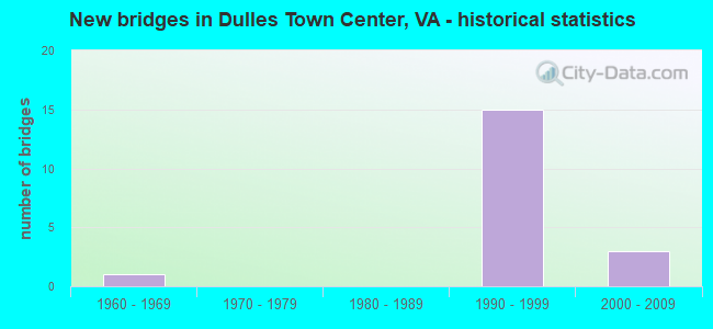
- New bridges - historical statistics
- 11960-1969
- 151990-1999
- 32000-2009
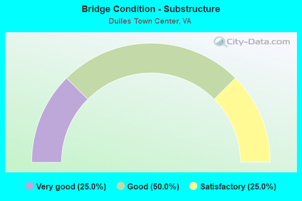
- Bridge Condition - Substructure
- 25.0%Very good
- 50.0%Good
- 25.0%Satisfactory
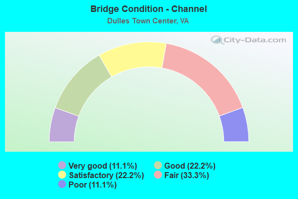
- Bridge Condition - Channel
- 11.1%Very good
- 22.2%Good
- 22.2%Satisfactory
- 33.3%Fair
- 11.1%Poor
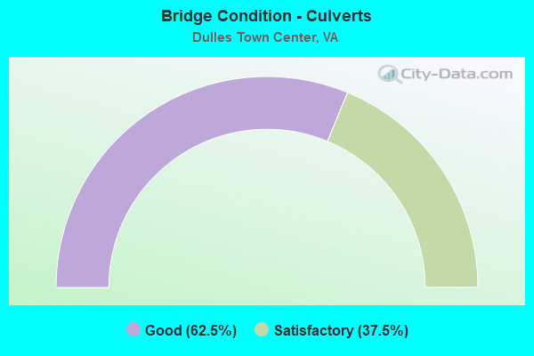
- Bridge Condition - Culverts
- 62.5%Good
- 37.5%Satisfactory
Find on map >> Show street view
Structure Number: 11047, Location: 00.05FR.7WB/00.05TO28SB (Lat: 39.044650, Lng: -77.428650), Route carried "on" structure: Ramp State highway 7, Year Built: 1990, Status: Open, Structure Length: 8.78m (28.81ft), Average Daily Traffic: 29,645 (year 2018), Truck Traffic: 3%, Average Future Daily Traffic: 75,700 (year 2035), Design Load: HS 20, Features Intersected: ROUTE 7
Minimum Vertical Clearance: 30+ m (98+ ft), Kilometerpoint: 0.000, Lanes on structure: 1, Lanes under structure: 6, Base Highway Network: Yes, Owner: State Highway Agency, Approaching Roadway Width: 10.7m (35.1ft), Skew: 4 degrees, Material/Design: Steel continuous, Design/Construction: Stringer/Multi-beam, Number Of Spans In Main Unit: 2, Length of Maximum Span: 51.5m (169.0ft), Curb-To-Curb Width: 8.7m (28.5ft), Out-to-Out Width: 9.7m (31.8ft)
Condition: Deck: Good, Superstructure: Good, Substructure: Good, Operating Rating: 88.0 metric tons, Method Used To Determine Operating Rating: Load and Resistance Factor (LRFR), Inventory Rating: 68.0 metric tons, Method Used To Determine Inventory Rating: Load and Resistance Factor (LRFR), Structural Evaluation: Better than present minimum criteria, Deck Geometry: Superior to present desirable criteria, Underclear: Better than present minimum criteria, Approach Roadway Alignment: Equal to present desirable criteria, Length Of Structure Improvement: 8.78m (28.81ft), Designated Inspection Frequency: Every 24 months, Inspection Date: July 2021, Bridge Improvement Cost: $60,000, Roadway Improvement Cost: $125,000, Total Project Cost: $200,000 ( Estimate for 2015), Deck Structure Type: Concrete Cast-file-Place, Wearing Surface/Protective System: Wearing Surface: Monolithic Concrete, Deck Protection: Epoxy Coated Reinforcing
Find on map >> Show street view
Structure Number: 11107, Location: 0.80FR625 0.30TO847 (Lat: 39.016906, Lng: -77.432122), Route carried "on" structure: State highway 28, Year Built: 1963, Status: Open, Structure Length: 1.16m (3.81ft), Average Daily Traffic: 150,837 (year 2020), Truck Traffic: 3%, Average Future Daily Traffic: 170,481 (year 2040), Design Load: HS 20, Features Intersected: CABIN BRANCH, Facility Carried by Structure: SULLY RD.
Minimum Vertical Clearance: 30+ m (98+ ft), Kilometerpoint: 69.477, Lanes on structure: 7, Base Highway Network: Yes, Owner: State Highway Agency, Approaching Roadway Width: 35.7m (117.1ft), Material/Design: Concrete, Design/Construction: Culvert, Number Of Spans In Main Unit: 4, Length of Maximum Span: 2.4m (7.9ft), Curb or Sidewalk Widths: Left: 2.7m (8.9ft), Right: 0.0m
Condition: Channel: Fair, Culverts: Satisfactory, Operating Rating: 89.8 metric tons, Method Used To Determine Operating Rating: Load Factor (LF), Inventory Rating: 89.8 metric tons, Method Used To Determine Inventory Rating: Load Factor (LF), Structural Evaluation: Equal to present minimum criteria, Waterway Adequacy: Equal to present desirable criteria, Approach Roadway Alignment: Equal to present desirable criteria, Length Of Structure Improvement: 0.61m (2.00ft), Designated Inspection Frequency: Every 24 months, Inspection Date: March 2021, Bridge Improvement Cost: $50,000, Roadway Improvement Cost: $10,000, Total Project Cost: $65,000
Find on map >> Show street view
Structure Number: 11111, Location: 0.10 Fr 7EBL/0.10 To 7WBL (Lat: 39.045322, Lng: -77.430647), Route carried "on" structure: Ramp State highway 28, Year Built: 1990, Status: Open, Structure Length: 8.17m (26.80ft), Average Daily Traffic: 75,418 (year 2020), Truck Traffic: 3%, Average Future Daily Traffic: 105,587 (year 2040), Design Load: HS 20, Features Intersected: ROUTE 7, Facility Carried by Structure: RAMP A OVER RTE. 7
Minimum Vertical Clearance: 30+ m (98+ ft), Kilometerpoint: 72.888, Lanes on structure: 2, Lanes under structure: 6, Base Highway Network: Yes, Owner: State Highway Agency, Approaching Roadway Width: 13.1m (43.0ft), Skew: 4 degrees, Material/Design: Steel continuous, Design/Construction: Stringer/Multi-beam, Number Of Spans In Main Unit: 2, Length of Maximum Span: 44.8m (147.0ft), Curb-To-Curb Width: 11.5m (37.7ft), Out-to-Out Width: 12.5m (41.0ft)
Condition: Deck: Good, Superstructure: Good, Substructure: Satisfactory, Operating Rating: 82.6 metric tons, Method Used To Determine Operating Rating: Load and Resistance Factor (LRFR), Inventory Rating: 63.5 metric tons, Method Used To Determine Inventory Rating: Load and Resistance Factor (LRFR), Structural Evaluation: Equal to present minimum criteria, Deck Geometry: Superior to present desirable criteria, Underclear: Equal to present minimum criteria, Approach Roadway Alignment: Equal to present desirable criteria, Length Of Structure Improvement: 8.17m (26.80ft), Designated Inspection Frequency: Every 24 months, Inspection Date: July 2021, Bridge Improvement Cost: $44,000, Roadway Improvement Cost: $99,000, Total Project Cost: $150,000 ( Estimate for 2015), Deck Structure Type: Concrete Cast-file-Place, Wearing Surface/Protective System: Wearing Surface: Monolithic Concrete, Deck Protection: Epoxy Coated Reinforcing
Find on map >> Show street view
Structure Number: 24644, Location: 00.60FR625/00.05TO679 (Lat: 39.015031, Lng: -77.413364), Route carried "on" structure: County highway 637, Year Built: 1994, Status: Open, Structure Length: 0.64m (2.10ft), Average Daily Traffic: 26,148 (year 2018), Truck Traffic: 3%, Average Future Daily Traffic: 38,788 (year 2035), Design Load: HS 20, Features Intersected: TRIB. CABIN BRANCH, Facility Carried by Structure: Cascades Parkway
Minimum Vertical Clearance: 30+ m (98+ ft), Kilometerpoint: 0.965, Lanes on structure: 5, Owner: State Highway Agency, Approaching Roadway Width: 19.5m (64.0ft), Skew: 3 degrees, Material/Design: Concrete, Design/Construction: Culvert, Number Of Spans In Main Unit: 3, Length of Maximum Span: 2.1m (6.9ft)
Condition: Channel: Poor, Culverts: Good, Operating Rating: 64.4 metric tons, Method Used To Determine Operating Rating: Load Factor (LF), Inventory Rating: 38.1 metric tons, Method Used To Determine Inventory Rating: Load Factor (LF), Structural Evaluation: Better than present minimum criteria, Waterway Adequacy: Better than present minimum criteria, Approach Roadway Alignment: Equal to present desirable criteria, Length Of Structure Improvement: 3.02m (9.91ft), Designated Inspection Frequency: Every 24 months, Inspection Date: April 2020, Bridge Improvement Cost: $65,000, Roadway Improvement Cost: $75,000, Total Project Cost: $175,000
Find on map >> Show street view
Structure Number: 24698, Location: 00.13 637 / 00.07 1525 (Lat: 39.007103, Lng: -77.421000), Route carried "on" structure: County highway 625, Year Built: 1996, Status: Open, Structure Length: 1.07m (3.51ft), Average Daily Traffic: 18,866 (year 2020), Truck Traffic: 1%, Average Future Daily Traffic: 26,412 (year 2040), Design Load: HS 20+Mod, Features Intersected: CABIN BRANCH, Facility Carried by Structure: CHURCH ROAD
Minimum Vertical Clearance: 30+ m (98+ ft), Kilometerpoint: 10.700, Lanes on structure: 4, Owner: State Highway Agency, Approaching Roadway Width: 18.6m (61.0ft), Skew: 2 degrees, Material/Design: Concrete, Design/Construction: Culvert, Number Of Spans In Main Unit: 3, Length of Maximum Span: 3.0m (9.8ft)
Condition: Channel: Satisfactory, Culverts: Good, Operating Rating: 63.5 metric tons, Method Used To Determine Operating Rating: Load Factor (LF), Inventory Rating: 38.1 metric tons, Method Used To Determine Inventory Rating: Load Factor (LF), Structural Evaluation: Better than present minimum criteria, Waterway Adequacy: Better than present minimum criteria, Approach Roadway Alignment: Equal to present desirable criteria, Length Of Structure Improvement: 11.89m (39.01ft), Designated Inspection Frequency: Every 24 months, Inspection Date: Febuary 2021, Bridge Improvement Cost: $36,000, Roadway Improvement Cost: $72,000, Total Project Cost: $140,000
Find on map >> Show street view
Structure Number: 247, Location: 00.15 1525 / 00.10 637 (Lat: 39.007247, Lng: -77.420306), Route carried "on" structure: County highway 625, Year Built: 1996, Status: Open, Structure Length: 1.28m (4.20ft), Average Daily Traffic: 18,866 (year 2020), Truck Traffic: 1%, Average Future Daily Traffic: 26,412 (year 2040), Design Load: HS 20+Mod, Features Intersected: BRANCH OF CABIN CREEK, Facility Carried by Structure: CHURCH ROAD
Minimum Vertical Clearance: 30+ m (98+ ft), Kilometerpoint: 10.780, Lanes on structure: 4, Owner: State Highway Agency, Approaching Roadway Width: 18.6m (61.0ft), Skew: 4 degrees, Material/Design: Concrete, Design/Construction: Culvert, Number Of Spans In Main Unit: 3, Length of Maximum Span: 4.0m (13.1ft)
Condition: Channel: Fair, Culverts: Good, Operating Rating: 60.8 metric tons, Method Used To Determine Operating Rating: Load Factor (LF), Inventory Rating: 36.3 metric tons, Method Used To Determine Inventory Rating: Load Factor (LF), Structural Evaluation: Better than present minimum criteria, Waterway Adequacy: Better than present minimum criteria, Approach Roadway Alignment: Equal to present desirable criteria, Length Of Structure Improvement: 11.89m (39.01ft), Designated Inspection Frequency: Every 24 months, Inspection Date: Febuary 2021, Bridge Improvement Cost: $39,000, Roadway Improvement Cost: $79,000, Total Project Cost: $150,000
Find on map >> Show street view
Structure Number: 25732, Location: 00.90FR1570/00.30TO28 (Lat: 39.041500, Lng: -77.423700), Route carried "on" structure: State highway 7, Year Built: 2002, Status: Open, Structure Length: 6.22m (20.41ft), Average Daily Traffic: 30,864 (year 2020), Truck Traffic: 3%, Average Future Daily Traffic: 43,210 (year 2040), Design Load: HS 20, Features Intersected: RTE.1582 ALGONKIAN PKWY, Facility Carried by Structure: HARRY BYRD HWY
Minimum Vertical Clearance: 30+ m (98+ ft), Kilometerpoint: 74.899, Lanes on structure: 4, Lanes under structure: 5, Base Highway Network: Yes, Owner: State Highway Agency, Approaching Roadway Width: 14.6m (47.9ft), Skew: 1 degrees, Material/Design: Steel continuous, Design/Construction: Stringer/Multi-beam, Number Of Spans In Main Unit: 2, Length of Maximum Span: 33.2m (108.9ft), Curb-To-Curb Width: 22.2m (72.8ft), Out-to-Out Width: 23.1m (75.8ft)
Condition: Deck: Good, Superstructure: Good, Substructure: Good, Operating Rating: 59.9 metric tons, Method Used To Determine Operating Rating: Load and Resistance Factor (LRFR), Inventory Rating: 43.5 metric tons, Method Used To Determine Inventory Rating: Load and Resistance Factor (LRFR), Structural Evaluation: Better than present minimum criteria, Deck Geometry: Superior to present desirable criteria, Underclear: Superior to present desirable criteria, Approach Roadway Alignment: Equal to present desirable criteria, Length Of Structure Improvement: 6.22m (20.41ft), Designated Inspection Frequency: Every 24 months, Inspection Date: December 2020, Bridge Improvement Cost: $55,000, Roadway Improvement Cost: $99,000, Total Project Cost: $200,000 ( Estimate for 2014), Deck Structure Type: Concrete Cast-file-Place, Wearing Surface/Protective System: Wearing Surface: Monolithic Concrete, Deck Protection: Epoxy Coated Reinforcing
Find on map >> Show street view
Structure Number: 26302, Location: .24ml Fr1902 .52ml To1949 (Lat: 39.036631, Lng: -77.425217), Route carried "on" structure: Alternate County highway 2124, Year Built: 1999, Status: Open, Structure Length: 0.67m (2.20ft), Average Daily Traffic: 643 (year 2019), Truck Traffic: 1%, Average Future Daily Traffic: 1,150 (year 2035), Design Load: HS 20, Features Intersected: TRIB. OF BROAD RUN, Facility Carried by Structure: DULLES CENTER BLVD
Minimum Vertical Clearance: 30.18m (99.02ft), Kilometerpoint: 0.000, Lanes on structure: 6, Owner: State Highway Agency, Approaching Roadway Width: 15.2m (49.9ft), Skew: 2 degrees, Material/Design: Concrete, Design/Construction: Culvert, Number Of Spans In Main Unit: 2, Length of Maximum Span: 3.2m (10.5ft)
Condition: Channel: Satisfactory, Culverts: Satisfactory, Operating Rating: 89.8 metric tons, Method Used To Determine Operating Rating: Load Factor (LF), Inventory Rating: 70.8 metric tons, Method Used To Determine Inventory Rating: Load Factor (LF), Structural Evaluation: Equal to present minimum criteria, Waterway Adequacy: Better than present minimum criteria, Approach Roadway Alignment: Better than present minimum criteria, Designated Inspection Frequency: Every 24 months, Inspection Date: March 2021
Find on map >> Show street view
Structure Number: 26304, Location: 00.39FR0000/00.15TO7 (Lat: 39.038267, Lng: -77.426461), Route carried "on" structure: County highway 1902, Year Built: 1998, Status: Open, Structure Length: 0.67m (2.20ft), Average Daily Traffic: 25,627 (year 2014), Truck Traffic: 3%, Average Future Daily Traffic: 28,959 (year 2040), Design Load: HS 20, Features Intersected: TRIB. OF BROAD RUN, Facility Carried by Structure: ATLANTIC BLVD
Minimum Vertical Clearance: 30+ m (98+ ft), Kilometerpoint: 0.000, Lanes on structure: 5, Owner: State Highway Agency, Approaching Roadway Width: 27.1m (88.9ft), Skew: 1 degrees, Material/Design: Concrete, Design/Construction: Culvert, Number Of Spans In Main Unit: 2, Length of Maximum Span: 3.0m (9.8ft)
Condition: Channel: Fair, Culverts: Satisfactory, Operating Rating: 89.8 metric tons, Method Used To Determine Operating Rating: Load Factor (LF), Inventory Rating: 89.7 metric tons, Method Used To Determine Inventory Rating: Load Factor (LF), Structural Evaluation: Equal to present minimum criteria, Waterway Adequacy: Better than present minimum criteria, Approach Roadway Alignment: Equal to present desirable criteria, Length Of Structure Improvement: 0.30m (0.98ft), Designated Inspection Frequency: Every 24 months, Inspection Date: April 2020, Bridge Improvement Cost: $1,000, Roadway Improvement Cost: $1,000, Total Project Cost: $3,000
Find on map >> Show street view
Structure Number: 27292, Location: 0.20frMAGN 0.20toVICT (Lat: 39.010772, Lng: -77.422075), Route carried "on" structure: Alternate County highway 3254, Year Built: 1997, Status: Open, Structure Length: 1.16m (3.81ft), Average Daily Traffic: 800 (year 2002), Truck Traffic: 2%, Average Future Daily Traffic: 1,500 (year 2020), Design Load: HS 20, Features Intersected: CABIN BRANCH, Facility Carried by Structure: BLOSSUM DRIVE
Minimum Vertical Clearance: 30.18m (99.02ft), Kilometerpoint: 0.000, Lanes on structure: 2, Owner: State Highway Agency, Approaching Roadway Width: 7.3m (24.0ft), Material/Design: Concrete, Design/Construction: Arch - Deck, Number Of Spans In Main Unit: 1, Length of Maximum Span: 11.0m (36.1ft), Curb or Sidewalk Widths: Left: 1.5m (4.9ft), Right: 1.5m (4.9ft), Curb-To-Curb Width: 7.3m (24.0ft), Out-to-Out Width: 36.6m (120.1ft)
Condition: Deck: Good, Superstructure: Good, Substructure: Very good, Channel: Good, Operating Rating: 89.8 metric tons, Method Used To Determine Operating Rating: Load and Resistance Factor (LRFR), Inventory Rating: 69.3 metric tons, Method Used To Determine Inventory Rating: Load and Resistance Factor (LRFR), Structural Evaluation: Better than present minimum criteria, Deck Geometry: Meets minimum limits, Waterway Adequacy: Better than present minimum criteria, Approach Roadway Alignment: Better than present minimum criteria, Designated Inspection Frequency: Every 24 months, Inspection Date: March 2020
Find on map >> Show street view
Structure Number: 31171, Location: 0.32FR1793 00.40TO7 (Lat: 39.032139, Lng: -77.418472), Route carried "on" structure: Alternate County highway 1345, Year Built: 1998, Status: Open, Structure Length: 0.64m (2.10ft), Average Daily Traffic: 9,000 (year 2017), Average Future Daily Traffic: 9,995 (year 2035), Design Load: HS 20, Features Intersected: TRIB OF BOARD RUN, Facility Carried by Structure: CITY CENTER BLVD.
Minimum Vertical Clearance: 30+ m (98+ ft), Kilometerpoint: 0.000, Lanes on structure: 6, Owner: State Highway Agency, Approaching Roadway Width: 11.0m (36.1ft), Skew: 3 degrees, Material/Design: Concrete, Design/Construction: Culvert, Number Of Spans In Main Unit: 2, Length of Maximum Span: 3.2m (10.5ft), Curb or Sidewalk Widths: Left: 0.2m (0.7ft), Right: 0.2m (0.7ft)
Condition: Channel: Good, Culverts: Good, Operating Rating: 54.4 metric tons, Method Used To Determine Operating Rating: Load Factor (LF), Inventory Rating: 32.7 metric tons, Method Used To Determine Inventory Rating: Load Factor (LF), Structural Evaluation: Better than present minimum criteria, Waterway Adequacy: Better than present minimum criteria, Approach Roadway Alignment: Better than present minimum criteria, Designated Inspection Frequency: Every 24 months, Inspection Date: October 2020
Find on map >> Show street view
Structure Number: 3123, Location: 00.15fr1902 00.58to637 (Lat: 39.020639, Lng: -77.421367), Route carried "on" structure: County highway 679, Year Built: 1993, Status: Open, Structure Length: 0.63m (2.07ft), Average Daily Traffic: 8,200 (year 2017), Truck Traffic: 23%, Average Future Daily Traffic: 8,827 (year 2035), Design Load: HS 20, Features Intersected: STORM WATER POND, Facility Carried by Structure: WOODLAND RD
Minimum Vertical Clearance: 30.18m (99.02ft), Kilometerpoint: 0.000, Lanes on structure: 4, Owner: State Highway Agency, Approaching Roadway Width: 14.3m (46.9ft), Skew: 2 degrees, Material/Design: Concrete, Design/Construction: Culvert, Number Of Spans In Main Unit: 2, Length of Maximum Span: 3.0m (9.8ft), Curb or Sidewalk Widths: Left: 0.2m (0.7ft), Right: 0.2m (0.7ft)
Condition: Channel: Very good, Culverts: Good, Operating Rating: 54.4 metric tons, Method Used To Determine Operating Rating: Load Factor (LF), Inventory Rating: 32.7 metric tons, Method Used To Determine Inventory Rating: Load Factor (LF), Structural Evaluation: Better than present minimum criteria, Waterway Adequacy: Better than present minimum criteria, Approach Roadway Alignment: Better than present minimum criteria, Designated Inspection Frequency: Every 24 months, Inspection Date: December 2020
Find on map >> Show street view
Structure Number: 11047, Location: 00.05FR.7WB/00.05TO28SB (Lat: 39.044650, Lng: -77.428650), Route carried "under" structure: Bypass State highway 7, Year Built: 1990, Structure Length: 0. m, Average Daily Traffic: 48,000 (year 1994), Features Intersected: ROUTE 7
Minimum Vertical Clearance: 6.48m (21.26ft), Kilometerpoint: 0.000, Lanes on structure: 1, Lanes under structure: 3, Material/Design: Steel continuous, Design/Construction: Stringer/Multi-beam, Length of Maximum Span: 51.5m (169.0ft)
Find on map >> Show street view
Structure Number: 11047, Location: 00.05FR.7WB/00.05TO28SB (Lat: 39.044650, Lng: -77.428650), Route carried "under" structure: Bypass State highway 7, Year Built: 1990, Structure Length: 0. m, Average Daily Traffic: 48,000 (year 1994), Features Intersected: ROUTE 7
Minimum Vertical Clearance: 5.39m (17.68ft), Kilometerpoint: 0.000, Lanes on structure: 1, Lanes under structure: 3, Material/Design: Steel continuous, Design/Construction: Stringer/Multi-beam, Length of Maximum Span: 51.5m (169.0ft)
Find on map >> Show street view
Structure Number: 11111, Location: 0.10 Fr 7EBL/0.10 To 7WBL (Lat: 39.045322, Lng: -77.430647), Route carried "under" structure: Interstate 7, Year Built: 1990, Structure Length: 0. m, Average Daily Traffic: 30,760 (year 1994), Features Intersected: ROUTE 7
Minimum Vertical Clearance: 5.51m (18.08ft), Kilometerpoint: 0.000, Lanes on structure: 2, Lanes under structure: 3, Material/Design: Steel continuous, Design/Construction: Stringer/Multi-beam, Length of Maximum Span: 44.8m (147.0ft)
Find on map >> Show street view
Structure Number: 11111, Location: 0.10 Fr 7EBL/0.10 To 7WBL (Lat: 39.045322, Lng: -77.430647), Route carried "under" structure: Interstate 7, Year Built: 1990, Structure Length: 0. m, Average Daily Traffic: 30,760 (year 1994), Features Intersected: ROUTE 7
Minimum Vertical Clearance: 6.76m (22.18ft), Kilometerpoint: 0.000, Lanes on structure: 2, Lanes under structure: 3, Material/Design: Steel continuous, Design/Construction: Stringer/Multi-beam, Length of Maximum Span: 44.8m (147.0ft)
Find on map >> Show street view
Structure Number: 11113, Location: 0.50 Fr 638/0.15 To 7 WBL (Lat: 39.043944, Lng: -77.430722), Route carried "under" structure: Business US 7, Year Built: 1991, Structure Length: 0. m, Average Daily Traffic: 4,350 (year 1994), Features Intersected: RAMP D OF ROUTE 7, Facility Carried by Structure: RAMP A OF RTE. 28
Minimum Vertical Clearance: 5.51m (18.08ft), Kilometerpoint: 0.000, Lanes on structure: 2, Lanes under structure: 1, Material/Design: Steel, Design/Construction: Stringer/Multi-beam, Length of Maximum Span: 36.9m (121.1ft)
Find on map >> Show street view
Structure Number: 25732, Location: 00.90FR1570/00.30TO28 (Lat: 39.041500, Lng: -77.423700), Route carried "under" structure: County highway 1582, Year Built: 2002, Structure Length: 0. m, Average Daily Traffic: 500 (year 2003), Features Intersected: RTE.1582 ALGONKIAN PKWY, Facility Carried by Structure: HARRY BYRD HWY
Minimum Vertical Clearance: 7.16m (23.49ft), Kilometerpoint: 0.000, Lanes on structure: 4, Lanes under structure: 3, Material/Design: Steel continuous, Design/Construction: Stringer/Multi-beam, Length of Maximum Span: 33.2m (108.9ft)
Find on map >> Show street view
Structure Number: 25732, Location: 00.90FR1570/00.30TO28 (Lat: 39.041500, Lng: -77.423700), Route carried "under" structure: Spur US 1582, Year Built: 2002, Structure Length: 0. m, Average Daily Traffic: 500 (year 2003), Features Intersected: RTE.1582 ALGONKIAN PKWY, Facility Carried by Structure: HARRY BYRD HWY
Minimum Vertical Clearance: 6.81m (22.34ft), Kilometerpoint: 0.000, Lanes on structure: 4, Lanes under structure: 2, Material/Design: Steel continuous, Design/Construction: Stringer/Multi-beam, Length of Maximum Span: 33.2m (108.9ft)