Bridge Statistics for Eagle, Michigan (MI)
Condition, Traffic, Stress, Structural Evaluation, Project Costs
- National Bridge Inventory (NBI) Statistics
- 10Number of bridges
- 115ft / 35.4mTotal length
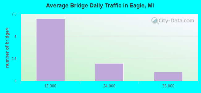
- 82,004Total average daily traffic
- 10,293Total average daily truck traffic
- National Bridge Inventory (NBI) Registered Bridges for Eagle
- No street view available for this location
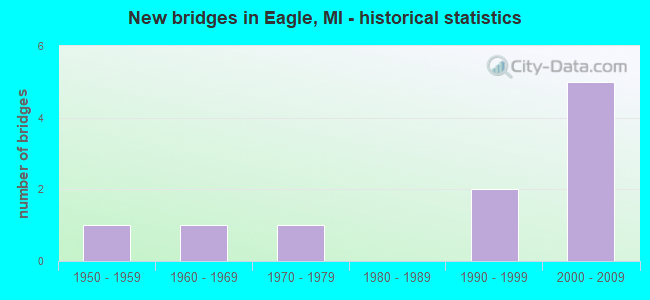
- New bridges - historical statistics
- 11950-1959
- 11960-1969
- 11970-1979
- 21990-1999
- 52000-2009
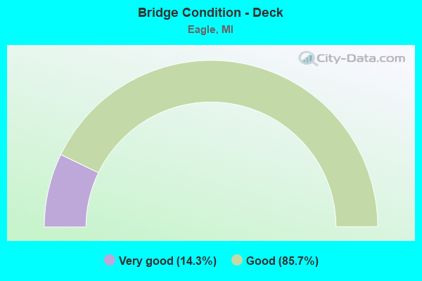
- Bridge Condition - Deck
- 14.3%Very good
- 85.7%Good
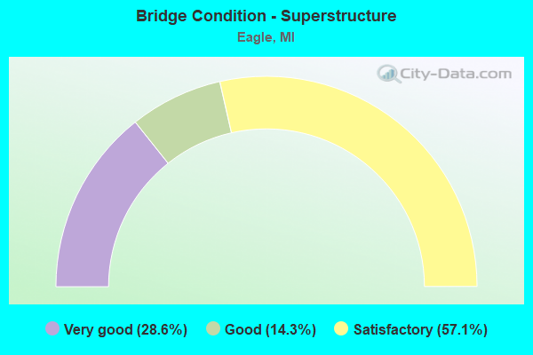
- Bridge Condition - Superstructure
- 28.6%Very good
- 14.3%Good
- 57.1%Satisfactory
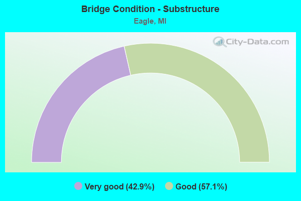
- Bridge Condition - Substructure
- 42.9%Very good
- 57.1%Good
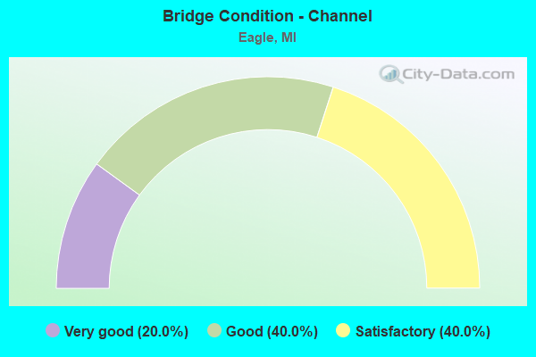
- Bridge Condition - Channel
- 20.0%Very good
- 40.0%Good
- 40.0%Satisfactory
Find on map >> Show street view
Structure Number: 1789, Location: 3.5 MI SE OF IONIA COL (Lat: 42.813100, Lng: -84.788583), Route carried "on" structure: Interstate 96, Year Built: 2007, Status: Open, Structure Length: 3.75m (12.30ft), Average Daily Traffic: 19,469 (year 2007), Truck Traffic: 13%, Average Future Daily Traffic: 22,727 (year 2018), Design Load: HS 25 or greater, Features Intersected: GRANGE RD
Minimum Vertical Clearance: 30.48m (100.00ft), Kilometerpoint: 4.257, Lanes on structure: 2, Lanes under structure: 2, Base Highway Network: Yes (Inventory Route: 20, Subroute: 1), Owner: State Highway Agency, Approaching Roadway Width: 13.4m (44.0ft), Skew: 12 degrees, Material/Design: Prestressed concrete, Design/Construction: Stringer/Multi-beam, Number Of Spans In Main Unit: 3, Length of Maximum Span: 14.4m (47.2ft), Curb-To-Curb Width: 13.4m (44.0ft), Out-to-Out Width: 14.4m (47.2ft)
Condition: Deck: Good, Superstructure: Satisfactory, Substructure: Good, Operating Rating: 63.8 metric tons, Method Used To Determine Operating Rating: Load Factor (LF) rating reported by rating factor (RF) method using MS18 loading, Inventory Rating: 33.4 metric tons, Method Used To Determine Inventory Rating: Load Factor (LF) rating reported by rating factor (RF) method using MS18 loading, Structural Evaluation: Equal to present minimum criteria, Deck Geometry: Superior to present desirable criteria, Underclear: Somewhat better than minimum adequacy, Approach Roadway Alignment: Equal to present desirable criteria, Designated Inspection Frequency: Every 24 months, Inspection Date: April 2020, Deck Structure Type: Concrete Cast-file-Place, Wearing Surface/Protective System: Wearing Surface: Integral Concrete, Deck Protection: Epoxy Coated Reinforcing
Find on map >> Show street view
Structure Number: 179, Location: 3.5 MI SE OF IONIA COL (Lat: 42.813372, Lng: -84.788586), Route carried "on" structure: Interstate 96, Year Built: 2007, Status: Open, Structure Length: 3.75m (12.30ft), Average Daily Traffic: 19,469 (year 2007), Truck Traffic: 13%, Average Future Daily Traffic: 22,727 (year 2018), Design Load: HS 25 or greater, Features Intersected: GRANGE RD
Minimum Vertical Clearance: 30.48m (100.00ft), Kilometerpoint: 4.258, Lanes on structure: 2, Lanes under structure: 2, Base Highway Network: Yes (Inventory Route: 20, Subroute: 2), Owner: State Highway Agency, Approaching Roadway Width: 13.4m (44.0ft), Skew: 12 degrees, Material/Design: Prestressed concrete, Design/Construction: Stringer/Multi-beam, Number Of Spans In Main Unit: 3, Length of Maximum Span: 14.4m (47.2ft), Curb-To-Curb Width: 13.4m (44.0ft), Out-to-Out Width: 14.4m (47.2ft)
Condition: Deck: Good, Superstructure: Satisfactory, Substructure: Good, Operating Rating: 63.8 metric tons, Method Used To Determine Operating Rating: Load Factor (LF) rating reported by rating factor (RF) method using MS18 loading, Inventory Rating: 33.4 metric tons, Method Used To Determine Inventory Rating: Load Factor (LF) rating reported by rating factor (RF) method using MS18 loading, Structural Evaluation: Equal to present minimum criteria, Deck Geometry: Superior to present desirable criteria, Underclear: Somewhat better than minimum adequacy, Approach Roadway Alignment: Equal to present minimum criteria, Designated Inspection Frequency: Every 24 months, Inspection Date: April 2020, Deck Structure Type: Concrete Cast-file-Place, Wearing Surface/Protective System: Wearing Surface: Integral Concrete, Deck Protection: Epoxy Coated Reinforcing
Find on map >> Show street view
Structure Number: 1895, Location: 0.1 MI E OF GRANGE RD (Lat: 42.784961, Lng: -84.798592), Route carried "on" structure: County highway , Year Built: 1979, Year Reconstructed: 2012, Status: Open, Structure Length: 7.56m (24.80ft), Average Daily Traffic: 875 (year 2012), Truck Traffic: 2%, Average Future Daily Traffic: 1,490 (year 2032), Design Load: Greater than HL93, Features Intersected: GRAND RIVER, Facility Carried by Structure: STATE ROAD
Minimum Vertical Clearance: 30.48m (100.00ft), Kilometerpoint: 3.151, Lanes on structure: 2, Owner: County Highway Agency, Approaching Roadway Width: 8.5m (27.9ft), Material/Design: Prestressed concrete, Design/Construction: Box Beam or Girders - Multiple, Number Of Spans In Main Unit: 4, Length of Maximum Span: 18.9m (62.0ft), Curb-To-Curb Width: 8.7m (28.5ft), Out-to-Out Width: 9.8m (32.2ft)
Condition: Deck: Very good, Superstructure: Very good, Substructure: Good, Channel: Satisfactory, Operating Rating: 70.3 metric tons, Method Used To Determine Operating Rating: Load and Resistance Factor Rating (LRFR) rating reported by rating factor(RF) method using HL-93 loadings, Inventory Rating: 54.1 metric tons, Method Used To Determine Inventory Rating: Load and Resistance Factor Rating (LRFR) rating reported by rating factor(RF) method using HL-93 loadings, Structural Evaluation: Better than present minimum criteria, Deck Geometry: Somewhat better than minimum adequacy, Waterway Adequacy: Equal to present minimum criteria, Approach Roadway Alignment: Equal to present minimum criteria, Designated Inspection Frequency: Every 24 months, Inspection Date: October 2020, Deck Structure Type: Concrete Cast-file-Place, Wearing Surface/Protective System: Wearing Surface: Monolithic Concrete, Deck Protection: Epoxy Coated Reinforcing
Find on map >> Show street view
Structure Number: 1897, Location: 100' W OF GRANGE RD (Lat: 42.842958, Lng: -84.797528), Route carried "on" structure: County highway , Year Built: 1966, Status: Open, Structure Length: 4.57m (14.99ft), Average Daily Traffic: 345 (year 2011), Truck Traffic: 2%, Average Future Daily Traffic: 623 (year 2031), Design Load: HS 20, Features Intersected: LOOKING GLASS RIVER, Facility Carried by Structure: HOWE ROAD
Minimum Vertical Clearance: 30.48m (100.00ft), Kilometerpoint: 3.208, Lanes on structure: 2, Owner: County Highway Agency, Approaching Roadway Width: 8.5m (27.9ft), Material/Design: Prestressed concrete, Design/Construction: Box Beam or Girders - Multiple, Number Of Spans In Main Unit: 3, Length of Maximum Span: 15.2m (49.9ft), Curb-To-Curb Width: 7.6m (24.9ft), Out-to-Out Width: 9.3m (30.5ft)
Condition: Deck: Good, Superstructure: Good, Substructure: Good, Channel: Satisfactory, Operating Rating: 55.4 metric tons, Method Used To Determine Operating Rating: Load Factor (LF), Inventory Rating: 33.2 metric tons, Method Used To Determine Inventory Rating: Load Factor (LF), Structural Evaluation: Better than present minimum criteria, Deck Geometry: Somewhat better than minimum adequacy, Waterway Adequacy: Equal to present desirable criteria, Approach Roadway Alignment: Equal to present desirable criteria, Designated Inspection Frequency: Every 24 months, Inspection Date: October 2020, Deck Structure Type: Other, Wearing Surface/Protective System: Wearing Surface: Bituminous
Find on map >> Show street view
Structure Number: 1916, Location: 1/2 S OF HERBISON (Lat: 42.824958, Lng: -84.788806), Route carried "on" structure: County highway 1911, Year Built: 2008, Status: Open, Structure Length: 4.28m (14.04ft), Average Daily Traffic: 2,311 (year 2011), Truck Traffic: 5%, Average Future Daily Traffic: 4,174 (year 2031), Design Load: HS 20, Features Intersected: LOOKING GLASS RIVER, Facility Carried by Structure: GRANGE ROAD
Minimum Vertical Clearance: 30.48m (100.00ft), Kilometerpoint: 2.034, Lanes on structure: 2, Owner: County Highway Agency, Approaching Roadway Width: 10.4m (34.1ft), Skew: 2 degrees, Material/Design: Prestressed concrete, Design/Construction: Box Beam or Girders - Multiple, Number Of Spans In Main Unit: 2, Length of Maximum Span: 21.4m (70.2ft), Curb-To-Curb Width: 9.8m (32.2ft), Out-to-Out Width: 10.5m (34.4ft)
Condition: Deck: Good, Superstructure: Very good, Substructure: Very good, Channel: Good, Operating Rating: 86.3 metric tons, Method Used To Determine Operating Rating: Load Factor (LF), Inventory Rating: 51.8 metric tons, Method Used To Determine Inventory Rating: Load Factor (LF), Structural Evaluation: Equal to present desirable criteria, Deck Geometry: Meets minimum limits, Waterway Adequacy: Equal to present minimum criteria, Approach Roadway Alignment: Somewhat better than minimum adequacy, Designated Inspection Frequency: Every 24 months, Inspection Date: October 2020, Deck Structure Type: Concrete Cast-file-Place, Wearing Surface/Protective System: Wearing Surface: Integral Concrete, Deck Protection: Epoxy Coated Reinforcing
Find on map >> Show street view
Structure Number: 1977, Location: 0.5 MI N OF STATE RD (Lat: 42.792647, Lng: -84.818161), Route carried "on" structure: ServiceCounty highway , Year Built: 1998, Status: Open, Structure Length: 7.50m (24.61ft), Average Daily Traffic: 1,192 (year 2011), Truck Traffic: 3%, Average Future Daily Traffic: 2,153 (year 2031), Design Load: HS 20, Features Intersected: GRAND RIVER, Facility Carried by Structure: JONES ROAD
Minimum Vertical Clearance: 30.48m (100.00ft), Kilometerpoint: 2.466, Lanes on structure: 2, Owner: County Highway Agency, Approaching Roadway Width: 9.4m (30.8ft), Skew: 2 degrees, Material/Design: Prestressed concrete, Design/Construction: Box Beam or Girders - Multiple, Number Of Spans In Main Unit: 3, Length of Maximum Span: 24.5m (80.4ft), Curb-To-Curb Width: 9.8m (32.2ft), Out-to-Out Width: 10.4m (34.1ft)
Condition: Deck: Good, Superstructure: Satisfactory, Substructure: Very good, Channel: Good, Operating Rating: 85.2 metric tons, Method Used To Determine Operating Rating: Load Factor (LF), Inventory Rating: 51.1 metric tons, Method Used To Determine Inventory Rating: Load Factor (LF), Structural Evaluation: Equal to present minimum criteria, Deck Geometry: Somewhat better than minimum adequacy, Waterway Adequacy: Equal to present desirable criteria, Approach Roadway Alignment: Equal to present desirable criteria, Designated Inspection Frequency: Every 24 months, Inspection Date: October 2021, Deck Structure Type: Concrete Cast-file-Place, Wearing Surface/Protective System: Wearing Surface: Integral Concrete, Deck Protection: Epoxy Coated Reinforcing
Find on map >> Show street view
Structure Number: 1978, Location: 0.1 MI S OF HERBISON (Lat: 42.827928, Lng: -84.759272), Route carried "on" structure: County highway , Year Built: 1996, Status: Open, Structure Length: 3.96m (12.99ft), Average Daily Traffic: 359 (year 2011), Truck Traffic: 1%, Average Future Daily Traffic: 648 (year 2031), Design Load: HS 20, Features Intersected: LOOKING GLASS RIVER, Facility Carried by Structure: TALLMAN ROAD
Minimum Vertical Clearance: 30.48m (100.00ft), Kilometerpoint: 1.560, Lanes on structure: 2, Owner: County Highway Agency, Approaching Roadway Width: 9.1m (29.9ft), Material/Design: Prestressed concrete, Design/Construction: Box Beam or Girders - Multiple, Number Of Spans In Main Unit: 1, Length of Maximum Span: 38.4m (126.0ft), Curb-To-Curb Width: 9.1m (29.9ft), Out-to-Out Width: 10.0m (32.8ft)
Condition: Deck: Good, Superstructure: Satisfactory, Substructure: Very good, Channel: Very good, Operating Rating: 67.8 metric tons, Method Used To Determine Operating Rating: Load Factor (LF), Inventory Rating: 40.7 metric tons, Method Used To Determine Inventory Rating: Load Factor (LF), Structural Evaluation: Equal to present minimum criteria, Deck Geometry: Equal to present minimum criteria, Waterway Adequacy: Better than present minimum criteria, Approach Roadway Alignment: Somewhat better than minimum adequacy, Designated Inspection Frequency: Every 24 months, Inspection Date: October 2021, Deck Structure Type: Concrete Cast-file-Place, Wearing Surface/Protective System: Wearing Surface: Integral Concrete, Deck Protection: Epoxy Coated Reinforcing
Find on map >> Show street view
Structure Number: 1788, Location: 1.3 MI SE OF IONIA COL (Lat: 42.821506, Lng: -84.818147), Route carried "under" structure: Interstate 96, Year Built: 1958, Structure Length: 0. m, Average Daily Traffic: 35,624 (year 2007), Truck Traffic: 14%, Features Intersected: I-96, Facility Carried by Structure: JONES RD
Minimum Vertical Clearance: 4.80m (15.75ft), Kilometerpoint: 1.666, Lanes on structure: 2, Lanes under structure: 4, Material/Design: Concrete continuous, Design/Construction: Tee Beam, Length of Maximum Span: 23.1m (75.8ft)
Find on map >> Show street view
Structure Number: 1789, Location: 3.5 MI SE OF IONIA COL (Lat: 42.813100, Lng: -84.788583), Route carried "under" structure: County highway 1911, Year Built: 2007, Structure Length: 0. m, Average Daily Traffic: 1,180 (year 0000), Truck Traffic: 3%, Features Intersected: GRANGE RD, Facility Carried by Structure: I-96 EB
Minimum Vertical Clearance: 4.52m (14.83ft), Kilometerpoint: 0.718, Lanes on structure: 2, Lanes under structure: 2, Material/Design: Prestressed concrete, Design/Construction: Stringer/Multi-beam, Length of Maximum Span: 14.4m (47.2ft)
Find on map >> Show street view
Structure Number: 179, Location: 3.5 MI SE OF IONIA COL (Lat: 42.813372, Lng: -84.788586), Route carried "under" structure: County highway 1911, Year Built: 2007, Structure Length: 0. m, Average Daily Traffic: 1,180 (year 0000), Truck Traffic: 3%, Features Intersected: GRANGE RD, Facility Carried by Structure: I-96 WB
Minimum Vertical Clearance: 30+ m (98+ ft), Kilometerpoint: 0.748, Lanes on structure: 2, Lanes under structure: 2, Material/Design: Prestressed concrete, Design/Construction: Stringer/Multi-beam, Length of Maximum Span: 14.4m (47.2ft)