Bridge Statistics for East Nassau, New York (NY)
Condition, Traffic, Stress, Structural Evaluation, Project Costs
- National Bridge Inventory (NBI) Statistics
- 22Number of bridges
- 161ft / 48.9mTotal length
- $29,002,000Total costs
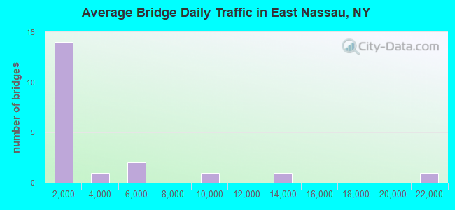
- 62,462Total average daily traffic
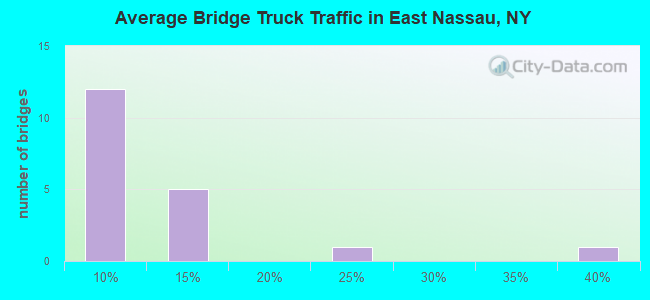
- 7,589Total average daily truck traffic
- National Bridge Inventory (NBI) Registered Bridges for East Nassau
- No street view available for this location
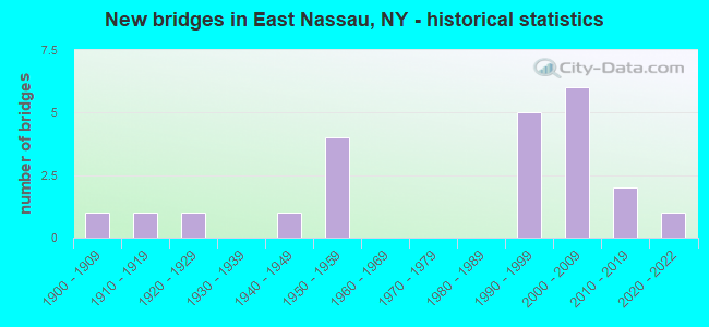
- New bridges - historical statistics
- 11900-1909
- 11910-1919
- 11920-1929
- 11940-1949
- 41950-1959
- 51990-1999
- 62000-2009
- 22010-2019
- 12020-2022
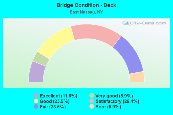
- Bridge Condition - Deck
- 11.8%Excellent
- 5.9%Very good
- 23.5%Good
- 29.4%Satisfactory
- 23.5%Fair
- 5.9%Poor
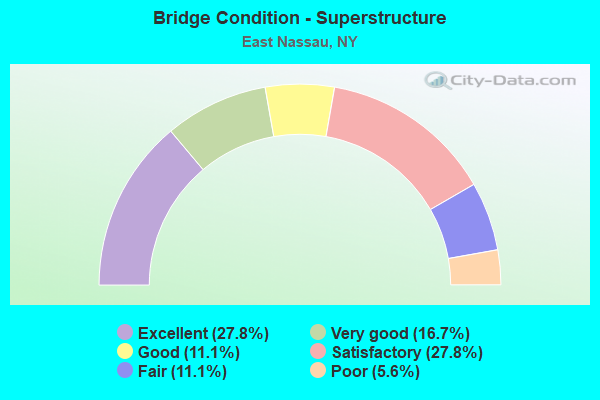
- Bridge Condition - Superstructure
- 27.8%Excellent
- 16.7%Very good
- 11.1%Good
- 27.8%Satisfactory
- 11.1%Fair
- 5.6%Poor
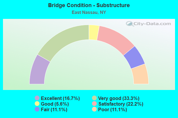
- Bridge Condition - Substructure
- 16.7%Excellent
- 33.3%Very good
- 5.6%Good
- 22.2%Satisfactory
- 11.1%Fair
- 11.1%Poor
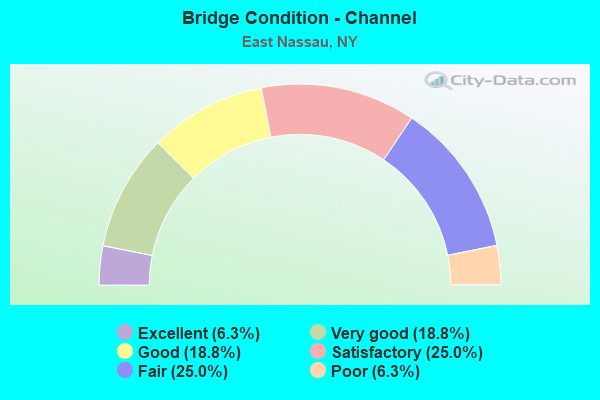
- Bridge Condition - Channel
- 6.3%Excellent
- 18.8%Very good
- 18.8%Good
- 25.0%Satisfactory
- 25.0%Fair
- 6.3%Poor
Find on map >> Show street view
Structure Number: 101601, Location: 0.4 MI E JCT RTS 20 & 66 (Lat: 42.495233, Lng: -73.535244), Route carried "on" structure: US 20, Year Built: 2015, Status: Open, Structure Length: 3.72m (12.20ft), Average Daily Traffic: 4,356 (year 2020), Truck Traffic: 9%, Average Future Daily Traffic: 4,880 (year 2040), Design Load: HL 93, Features Intersected: KINDERHOOK CREEK
Minimum Vertical Clearance: 30+ m (98+ ft), Kilometerpoint: 27.176, Lanes on structure: 2, Base Highway Network: Yes, Owner: State Highway Agency, Approaching Roadway Width: 11.0m (36.1ft), Skew: 1 degrees, Material/Design: Steel, Design/Construction: Stringer/Multi-beam, Number Of Spans In Main Unit: 1, Length of Maximum Span: 36.6m (120.1ft), Curb-To-Curb Width: 11.0m (36.1ft), Out-to-Out Width: 11.9m (39.0ft)
Condition: Deck: Good, Superstructure: Excellent, Substructure: Excellent, Channel: Very good, Inventory Rating: 61.7 metric tons, Method Used To Determine Inventory Rating: Load Factor (LF), Structural Evaluation: Superior to present desirable criteria, Deck Geometry: Somewhat better than minimum adequacy, Waterway Adequacy: Superior to present desirable criteria, Approach Roadway Alignment: Equal to present desirable criteria, Length Of Structure Improvement: 3.71m (12.17ft), Designated Inspection Frequency: Every 24 months, Inspection Date: October 2021, Bridge Improvement Cost: $1,104,000, Roadway Improvement Cost: $647,000, Total Project Cost: $1,751,000 ( Estimate for 2021), Deck Structure Type: Concrete Cast-file-Place, Wearing Surface/Protective System: Wearing Surface: Integral Concrete, Deck Protection: Epoxy Coated Reinforcing
Find on map >> Show street view
Structure Number: 101602, Location: 0.7 MI E JCT RTS 20 & 66 (Lat: 42.497378, Lng: -73.530047), Route carried "on" structure: US 20, Year Built: 2017, Status: Open, Structure Length: 3.72m (12.20ft), Average Daily Traffic: 4,356 (year 2020), Truck Traffic: 9%, Average Future Daily Traffic: 4,880 (year 2040), Design Load: HL 93, Features Intersected: KINDERHOOK CREEK
Minimum Vertical Clearance: 30+ m (98+ ft), Kilometerpoint: 27.691, Lanes on structure: 2, Base Highway Network: Yes, Owner: State Highway Agency, Approaching Roadway Width: 11.0m (36.1ft), Material/Design: Steel, Design/Construction: Stringer/Multi-beam, Number Of Spans In Main Unit: 1, Length of Maximum Span: 36.6m (120.1ft), Curb-To-Curb Width: 11.0m (36.1ft), Out-to-Out Width: 12.0m (39.4ft)
Condition: Deck: Good, Superstructure: Excellent, Substructure: Excellent, Channel: Good, Operating Rating: 60.6 metric tons, Method Used To Determine Operating Rating: Load and Resistance Factor Rating (LRFR) rating reported by rating factor(RF) method using HL-93 loadings, Inventory Rating: 46.7 metric tons, Method Used To Determine Inventory Rating: Load and Resistance Factor Rating (LRFR) rating reported by rating factor(RF) method using HL-93 loadings, Structural Evaluation: Superior to present desirable criteria, Deck Geometry: Somewhat better than minimum adequacy, Waterway Adequacy: Equal to present desirable criteria, Approach Roadway Alignment: Equal to present desirable criteria, Length Of Structure Improvement: 3.71m (12.17ft), Designated Inspection Frequency: Every 24 months, Inspection Date: June 2021, Bridge Improvement Cost: $1,129,000, Roadway Improvement Cost: $661,000, Total Project Cost: $1,790,000 ( Estimate for 2021), Deck Structure Type: Concrete Cast-file-Place, Wearing Surface/Protective System: Wearing Surface: Integral Concrete, Deck Protection: Epoxy Coated Reinforcing
Find on map >> Show street view
Structure Number: 102538, Location: RTE 43 AT DUNHAM HOLLOW (Lat: 42.585556, Lng: -73.485294), Route carried "on" structure: State highway 43, Year Built: 2005, Status: Open, Structure Length: 0.98m (3.22ft), Average Daily Traffic: 2,552 (year 2020), Truck Traffic: 7%, Average Future Daily Traffic: 2,662 (year 2040), Design Load: HS 25 or greater, Features Intersected: TSATSAWASSA CREEK
Minimum Vertical Clearance: 30+ m (98+ ft), Kilometerpoint: 23.845, Lanes on structure: 2, Base Highway Network: Yes, Owner: State Highway Agency, Approaching Roadway Width: 8.8m (28.9ft), Material/Design: Concrete, Design/Construction: Frame, Number Of Spans In Main Unit: 1, Length of Maximum Span: 9.1m (29.9ft), Curb-To-Curb Width: 8.8m (28.9ft), Out-to-Out Width: 9.8m (32.2ft)
Condition: Superstructure: Good, Substructure: Very good, Channel: Satisfactory, Operating Rating: 73.5 metric tons, Method Used To Determine Operating Rating: Load Factor (LF), Inventory Rating: 44.5 metric tons, Method Used To Determine Inventory Rating: Load Factor (LF), Structural Evaluation: Better than present minimum criteria, Deck Geometry: Meets minimum limits, Waterway Adequacy: Equal to present minimum criteria, Approach Roadway Alignment: Equal to present desirable criteria, Length Of Structure Improvement: 0.97m (3.18ft), Designated Inspection Frequency: Every 24 months, Inspection Date: June 2021, Bridge Improvement Cost: $265,000, Roadway Improvement Cost: $155,000, Total Project Cost: $420,000 ( Estimate for 2021)
Find on map >> Show street view
Structure Number: 102907, Location: 1.4 MI N JCT RTE66+I90 (Lat: 42.480425, Lng: -73.566614), Route carried "on" structure: State highway 66, Year Built: 1913, Status: Open, Structure Length: 0.79m (2.59ft), Average Daily Traffic: 365 (year 2018), Truck Traffic: 7%, Average Future Daily Traffic: 380 (year 2040), Design Load: HS 20, Features Intersected: GREEN BROOK
Minimum Vertical Clearance: 30+ m (98+ ft), Kilometerpoint: 36.878, Lanes on structure: 2, Base Highway Network: Yes, Owner: State Highway Agency, Approaching Roadway Width: 7.3m (24.0ft), Material/Design: Concrete, Design/Construction: Slab, Number Of Spans In Main Unit: 1, Length of Maximum Span: 6.4m (21.0ft), Curb-To-Curb Width: 7.8m (25.6ft), Out-to-Out Width: 8.6m (28.2ft)
Condition: Deck: Satisfactory, Superstructure: Satisfactory, Substructure: Poor, Channel: Fair, Operating Rating: 47.2 metric tons, Method Used To Determine Operating Rating: Load Factor (LF), Inventory Rating: 28.1 metric tons, Method Used To Determine Inventory Rating: Load Factor (LF), Structural Evaluation: Meets minimum limits, Deck Geometry: Somewhat better than minimum adequacy, Waterway Adequacy: Meets minimum limits, Approach Roadway Alignment: Meets minimum limits, Length Of Structure Improvement: 0.79m (2.59ft), Designated Inspection Frequency: Every 24 months, Inspection Date: August 2021, Bridge Improvement Cost: $259,000, Roadway Improvement Cost: $152,000, Total Project Cost: $410,000 ( Estimate for 2021), Wearing Surface/Protective System: Wearing Surface: Bituminous, Membrane: Other
Find on map >> Show street view
Structure Number: 102908, Location: S.H.66 AT EAST NASSAU (Lat: 42.506897, Lng: -73.507547), Route carried "on" structure: State highway 66, Year Built: 2004, Status: Open, Structure Length: 3.72m (12.20ft), Average Daily Traffic: 1,271 (year 2015), Truck Traffic: 11%, Average Future Daily Traffic: 1,325 (year 2040), Design Load: HS 25 or greater, Features Intersected: KINDERHOOK CREEK
Minimum Vertical Clearance: 30+ m (98+ ft), Kilometerpoint: 5.744, Lanes on structure: 2, Base Highway Network: Yes, Owner: State Highway Agency, Approaching Roadway Width: 9.1m (29.9ft), Material/Design: Steel, Design/Construction: Stringer/Multi-beam, Number Of Spans In Main Unit: 1, Length of Maximum Span: 36.0m (118.1ft), Curb or Sidewalk Widths: Left: 0.0m, Right: 1.7m (5.6ft), Curb-To-Curb Width: 9.2m (30.2ft), Out-to-Out Width: 11.9m (39.0ft)
Condition: Deck: Very good, Superstructure: Very good, Substructure: Very good, Channel: Very good, Operating Rating: 83.5 metric tons, Method Used To Determine Operating Rating: Load Factor (LF), Inventory Rating: 49.9 metric tons, Method Used To Determine Inventory Rating: Load Factor (LF), Structural Evaluation: Equal to present desirable criteria, Deck Geometry: Somewhat better than minimum adequacy, Waterway Adequacy: Equal to present minimum criteria, Approach Roadway Alignment: Equal to present desirable criteria, Length Of Structure Improvement: 3.71m (12.17ft), Designated Inspection Frequency: Every 24 months, Inspection Date: May 2020, Bridge Improvement Cost: $1,355,000, Roadway Improvement Cost: $794,000, Total Project Cost: $2,149,000 ( Estimate for 2021), Deck Structure Type: Concrete Cast-file-Place, Wearing Surface/Protective System: Wearing Surface: Monolithic Concrete, Deck Protection: Epoxy Coated Reinforcing
Find on map >> Show street view
Structure Number: 102909, Location: 0.2 MI N OF E.NASSAU (Lat: 42.512717, Lng: -73.509050), Route carried "on" structure: State highway 66, Year Built: 1928, Status: Open, Structure Length: 0.73m (2.40ft), Average Daily Traffic: 1,271 (year 2015), Truck Traffic: 11%, Average Future Daily Traffic: 1,325 (year 2040), Features Intersected: BLACK BROOK
Minimum Vertical Clearance: 30+ m (98+ ft), Kilometerpoint: 6.484, Lanes on structure: 2, Base Highway Network: Yes, Owner: State Highway Agency, Approaching Roadway Width: 9.4m (30.8ft), Skew: 3 degrees, Material/Design: Concrete, Design/Construction: Slab, Number Of Spans In Main Unit: 1, Length of Maximum Span: 6.0m (19.7ft), Curb-To-Curb Width: 9.4m (30.8ft), Out-to-Out Width: 10.1m (33.1ft)
Condition: Deck: Poor, Superstructure: Poor, Substructure: Fair, Channel: Poor, Operating Rating: 75.3 metric tons, Method Used To Determine Operating Rating: Load Factor (LF), Inventory Rating: 44.5 metric tons, Method Used To Determine Inventory Rating: Load Factor (LF), Structural Evaluation: Meets minimum limits, Deck Geometry: Somewhat better than minimum adequacy, Waterway Adequacy: Meets minimum limits, Approach Roadway Alignment: Equal to present desirable criteria, Length Of Structure Improvement: 0.73m (2.40ft), Designated Inspection Frequency: Every 24 months, Inspection Date: July 2020, Bridge Improvement Cost: $456,000, Roadway Improvement Cost: $267,000, Total Project Cost: $723,000 ( Estimate for 2021), Wearing Surface/Protective System: Wearing Surface: Bituminous
Find on map >> Show street view
Structure Number: 10291, Location: RTE 66 AT HOAG CORNERS (Lat: 42.556956, Lng: -73.511256), Route carried "on" structure: State highway 66, Year Built: 1901, Status: Open, Structure Length: 1.55m (5.09ft), Average Daily Traffic: 1,202 (year 2020), Truck Traffic: 10%, Average Future Daily Traffic: 1,253 (year 2040), Features Intersected: TSATSAWASSA CREEK
Minimum Vertical Clearance: 30+ m (98+ ft), Kilometerpoint: 11.472, Lanes on structure: 2, Base Highway Network: Yes, Owner: State Highway Agency, Approaching Roadway Width: 10.1m (33.1ft), Skew: 3 degrees, Material/Design: Steel, Design/Construction: Stringer/Multi-beam, Number Of Spans In Main Unit: 1, Length of Maximum Span: 14.9m (48.9ft), Curb-To-Curb Width: 10.1m (33.1ft), Out-to-Out Width: 10.7m (35.1ft)
Condition: Deck: Fair, Superstructure: Satisfactory, Substructure: Satisfactory, Channel: Fair, Operating Rating: 83.5 metric tons, Method Used To Determine Operating Rating: Load Factor (LF), Inventory Rating: 49.9 metric tons, Method Used To Determine Inventory Rating: Load Factor (LF), Structural Evaluation: Equal to present minimum criteria, Deck Geometry: Somewhat better than minimum adequacy, Waterway Adequacy: Meets minimum limits, Approach Roadway Alignment: Equal to present desirable criteria, Length Of Structure Improvement: 1.55m (5.09ft), Designated Inspection Frequency: Every 24 months, Inspection Date: October 2020, Bridge Improvement Cost: $578,000, Roadway Improvement Cost: $338,000, Total Project Cost: $916,000 ( Estimate for 2021), Deck Structure Type: Concrete Cast-file-Place, Wearing Surface/Protective System: Wearing Surface: Integral Concrete, Deck Protection: Epoxy Coated Reinforcing
Find on map >> Show street view
Structure Number: 220187, Location: 3.3 MI NE NASSAU VILLAGE (Lat: 42.555819, Lng: -73.506978), Route carried "on" structure: Other road , Year Built: 2020, Status: Open, Structure Length: 1.52m (4.99ft), Average Daily Traffic: 10 (year 2014), Average Future Daily Traffic: 14 (year 2034), Features Intersected: TSATSAWASSA CREEK, Facility Carried by Structure: MURDOCK ROAD
Minimum Vertical Clearance: 30+ m (98+ ft), Kilometerpoint: 0.000, Lanes on structure: 2, Owner: Town or Township Highway Agency, Approaching Roadway Width: 6.1m (20.0ft), Material/Design: Concrete, Design/Construction: Box Beam or Girders - Multiple, Number Of Spans In Main Unit: 1, Length of Maximum Span: 14.9m (48.9ft), Curb-To-Curb Width: 6.1m (20.0ft), Out-to-Out Width: 7.1m (23.3ft)
Condition: Deck: Excellent, Superstructure: Excellent, Substructure: Excellent, Channel: Excellent, Operating Rating: 53.5 metric tons, Method Used To Determine Operating Rating: Load and Resistance Factor Rating (LRFR) rating reported by rating factor(RF) method using HL-93 loadings, Inventory Rating: 41.1 metric tons, Method Used To Determine Inventory Rating: Load and Resistance Factor Rating (LRFR) rating reported by rating factor(RF) method using HL-93 loadings, Structural Evaluation: Superior to present desirable criteria, Deck Geometry: Somewhat better than minimum adequacy, Waterway Adequacy: Meets minimum limits, Approach Roadway Alignment: Somewhat better than minimum adequacy, Length Of Structure Improvement: 1.31m (4.30ft), Designated Inspection Frequency: Every 24 months, Inspection Date: May 2021, Bridge Improvement Cost: $300,000, Roadway Improvement Cost: $176,000, Total Project Cost: $476,000 ( Estimate for 2021), Deck Structure Type: Concrete Cast-file-Place, Wearing Surface/Protective System: Wearing Surface: Integral Concrete, Deck Protection: Epoxy Coated Reinforcing
Find on map >> Show street view
Structure Number: 227117, Location: 0.3 MI W JCT NY RT 66 (Lat: 42.515953, Lng: -73.514478), Route carried "on" structure: Other road , Year Built: 1953, Status: Open, Structure Length: 2.07m (6.79ft), Features Intersected: TACKAWASICK CREEK, Facility Carried by Structure: TSATSAWASSA LAKE R
Minimum Vertical Clearance: 32.69m (107.25ft), Kilometerpoint: 0.241, Lanes on structure: 2, Owner: Town or Township Highway Agency, Approaching Roadway Width: 6.1m (20.0ft), Skew: 1 degrees, Material/Design: Concrete, Design/Construction: Stringer/Multi-beam, Number Of Spans In Main Unit: 1, Length of Maximum Span: 19.8m (65.0ft), Curb-To-Curb Width: 6.1m (20.0ft), Out-to-Out Width: 6.5m (21.3ft)
Condition: Deck: Satisfactory, Superstructure: Fair, Substructure: Fair, Channel: Fair, Operating Rating: 58.3 metric tons, Method Used To Determine Operating Rating: Field evaluation and documented engineering judgment, Inventory Rating: 23.0 metric tons, Method Used To Determine Inventory Rating: Field evaluation and documented engineering judgment, Structural Evaluation: Somewhat better than minimum adequacy, Deck Geometry: Somewhat better than minimum adequacy, Waterway Adequacy: Better than present minimum criteria, Approach Roadway Alignment: Better than present minimum criteria, Length Of Structure Improvement: 2.07m (6.79ft), Designated Inspection Frequency: Every 24 months, Inspection Date: June 2020, Bridge Improvement Cost: $281,000, Roadway Improvement Cost: $164,000, Total Project Cost: $445,000 ( Estimate for 2021), Deck Structure Type: Concrete Cast-file-Place, Wearing Surface/Protective System: Wearing Surface: Bituminous
Find on map >> Show street view
Structure Number: 322209, Location: 1.1 MI NE OF MALDEN BRIDG (Lat: 42.480683, Lng: -73.567714), Route carried "on" structure: Other road , Year Built: 1950, Status: Open, Structure Length: 4.33m (14.21ft), Truck Traffic: 10%, Features Intersected: KINDERHOOK CREEK, Facility Carried by Structure: BACHUS ROAD
Minimum Vertical Clearance: 30+ m (98+ ft), Kilometerpoint: 0.805, Lanes on structure: 2, Owner: County Highway Agency, Approaching Roadway Width: 4.9m (16.1ft), Material/Design: Steel, Design/Construction: Stringer/Multi-beam, Number Of Spans In Main Unit: 2, Length of Maximum Span: 21.0m (68.9ft), Curb-To-Curb Width: 5.4m (17.7ft), Out-to-Out Width: 5.7m (18.7ft)
Condition: Deck: Fair, Superstructure: Satisfactory, Substructure: Satisfactory, Channel: Fair, Operating Rating: 56.2 metric tons, Method Used To Determine Operating Rating: Load Factor (LF), Inventory Rating: 33.6 metric tons, Method Used To Determine Inventory Rating: Load Factor (LF), Structural Evaluation: Equal to present minimum criteria, Deck Geometry: High priority of corrective action, Waterway Adequacy: Meets minimum limits, Approach Roadway Alignment: Equal to present minimum criteria, Length Of Structure Improvement: 4.32m (14.17ft), Designated Inspection Frequency: Every 24 months, Inspection Date: April 2020, Bridge Improvement Cost: $1,252,000, Roadway Improvement Cost: $733,000, Total Project Cost: $1,986,000 ( Estimate for 2021), Deck Structure Type: Open Grating, Wearing Surface/Protective System: Wearing Surface: Other
Find on map >> Show street view
Structure Number: 330385, Location: 0.1 MI E OF HOAG CORNERS (Lat: 42.555833, Lng: -73.509733), Route carried "on" structure: County highway , Year Built: 1990, Status: Open, Structure Length: 2.04m (6.69ft), Average Daily Traffic: 356 (year 2017), Truck Traffic: 7%, Average Future Daily Traffic: 498 (year 2037), Design Load: HS 20, Features Intersected: TSATSAWASSA CREEK, Facility Carried by Structure: DUNHAM HOLLOW RD
Minimum Vertical Clearance: 30+ m (98+ ft), Kilometerpoint: 0.145, Lanes on structure: 2, Owner: County Highway Agency, Approaching Roadway Width: 7.3m (24.0ft), Skew: 3 degrees, Material/Design: Prestressed concrete, Design/Construction: Box Beam or Girders - Multiple, Number Of Spans In Main Unit: 1, Length of Maximum Span: 18.2m (59.7ft), Curb-To-Curb Width: 7.6m (24.9ft), Out-to-Out Width: 8.2m (26.9ft)
Condition: Deck: Satisfactory, Superstructure: Very good, Substructure: Very good, Channel: Very good, Operating Rating: 67.1 metric tons, Method Used To Determine Operating Rating: Load Factor (LF), Inventory Rating: 35.4 metric tons, Method Used To Determine Inventory Rating: Load Factor (LF), Structural Evaluation: Equal to present desirable criteria, Deck Geometry: Somewhat better than minimum adequacy, Waterway Adequacy: Equal to present minimum criteria, Approach Roadway Alignment: Equal to present desirable criteria, Length Of Structure Improvement: 2.04m (6.69ft), Designated Inspection Frequency: Every 24 months, Inspection Date: September 2021, Bridge Improvement Cost: $778,000, Roadway Improvement Cost: $455,000, Total Project Cost: $1,233,000 ( Estimate for 2021), Deck Structure Type: Concrete Cast-file-Place, Wearing Surface/Protective System: Wearing Surface: Bituminous, Deck Protection: Epoxy Coated Reinforcing
Find on map >> Show street view
Structure Number: 330386, Location: 0.6MI NE HOAGS CORNERS (Lat: 42.560219, Lng: -73.500922), Route carried "on" structure: County highway , Year Built: 1991, Status: Open, Structure Length: 1.62m (5.31ft), Average Daily Traffic: 356 (year 2017), Truck Traffic: 7%, Average Future Daily Traffic: 498 (year 2037), Features Intersected: TSATSAWSSA CREEK, Facility Carried by Structure: CR21DUNHAM HOLLOW
Minimum Vertical Clearance: 30+ m (98+ ft), Kilometerpoint: 1.223, Lanes on structure: 2, Owner: County Highway Agency, Approaching Roadway Width: 7.9m (25.9ft), Skew: 3 degrees, Material/Design: Steel, Design/Construction: Stringer/Multi-beam, Number Of Spans In Main Unit: 1, Length of Maximum Span: 15.8m (51.8ft), Curb-To-Curb Width: 7.9m (25.9ft), Out-to-Out Width: 8.5m (27.9ft)
Condition: Deck: Satisfactory, Superstructure: Fair, Substructure: Satisfactory, Channel: Good, Operating Rating: 45.0 metric tons, Method Used To Determine Operating Rating: Load and Resistance Factor Rating (LRFR) rating reported by rating factor(RF) method using HL-93 loadings, Inventory Rating: 34.7 metric tons, Method Used To Determine Inventory Rating: Load and Resistance Factor Rating (LRFR) rating reported by rating factor(RF) method using HL-93 loadings, Structural Evaluation: Somewhat better than minimum adequacy, Deck Geometry: Somewhat better than minimum adequacy, Waterway Adequacy: Meets minimum limits, Approach Roadway Alignment: Equal to present minimum criteria, Length Of Structure Improvement: 1.61m (5.28ft), Designated Inspection Frequency: Every 24 months, Inspection Date: May 2020, Bridge Improvement Cost: $527,000, Roadway Improvement Cost: $309,000, Total Project Cost: $835,000 ( Estimate for 2021), Deck Structure Type: Wood or Timber, Wearing Surface/Protective System: Wearing Surface: Bituminous, Membrane: Other
Find on map >> Show street view
Structure Number: 330387, Location: 1.5 MI SE OF ALPS (Lat: 42.583592, Lng: -73.487361), Route carried "on" structure: County highway , Year Built: 1990, Year Reconstructed: 2018, Status: Open, Structure Length: 1.83m (6.00ft), Average Daily Traffic: 356 (year 2017), Truck Traffic: 7%, Average Future Daily Traffic: 498 (year 2037), Features Intersected: TACKAWASICK CREEK, Facility Carried by Structure: DUNHAM HOLLOW RD
Minimum Vertical Clearance: 30+ m (98+ ft), Kilometerpoint: 4.312, Lanes on structure: 2, Owner: County Highway Agency, Approaching Roadway Width: 7.3m (24.0ft), Material/Design: Steel, Design/Construction: Stringer/Multi-beam, Number Of Spans In Main Unit: 1, Length of Maximum Span: 17.4m (57.1ft), Curb-To-Curb Width: 7.3m (24.0ft), Out-to-Out Width: 8.5m (27.9ft)
Condition: Deck: Excellent, Superstructure: Excellent, Substructure: Satisfactory, Channel: Satisfactory, Operating Rating: 84.9 metric tons, Method Used To Determine Operating Rating: Field evaluation and documented engineering judgment, Inventory Rating: 32.7 metric tons, Method Used To Determine Inventory Rating: Field evaluation and documented engineering judgment, Structural Evaluation: Equal to present minimum criteria, Deck Geometry: Somewhat better than minimum adequacy, Waterway Adequacy: Somewhat better than minimum adequacy, Approach Roadway Alignment: Equal to present desirable criteria, Length Of Structure Improvement: 1.82m (5.97ft), Designated Inspection Frequency: Every 24 months, Inspection Date: July 2020, Bridge Improvement Cost: $601,000, Roadway Improvement Cost: $352,000, Total Project Cost: $954,000 ( Estimate for 2021), Deck Structure Type: Concrete Cast-file-Place, Wearing Surface/Protective System: Wearing Surface: Integral Concrete, Deck Protection: Epoxy Coated Reinforcing
Find on map >> Show street view
Structure Number: 330388, Location: 2.3 MI NW OF STEVETWN CTR (Lat: 42.584772, Lng: -73.485617), Route carried "on" structure: County highway , Year Built: 1949, Status: Posted for load, Structure Length: 1.34m (4.40ft), Average Daily Traffic: 356 (year 2017), Truck Traffic: 7%, Average Future Daily Traffic: 498 (year 2037), Features Intersected: TAKAWASICK CREEK, Facility Carried by Structure: DUNHAM HOLLOW RD
Minimum Vertical Clearance: 30+ m (98+ ft), Kilometerpoint: 4.505, Lanes on structure: 2, Owner: County Highway Agency, Approaching Roadway Width: 6.4m (21.0ft), Skew: 3 degrees, Material/Design: Steel, Design/Construction: Stringer/Multi-beam, Number Of Spans In Main Unit: 1, Length of Maximum Span: 13.1m (43.0ft), Curb-To-Curb Width: 6.3m (20.7ft), Out-to-Out Width: 6.5m (21.3ft)
Condition: Deck: Fair, Superstructure: Satisfactory, Substructure: Poor, Channel: Satisfactory, Operating Rating: 38.1 metric tons, Method Used To Determine Operating Rating: Load Factor (LF), Inventory Rating: 22.7 metric tons, Method Used To Determine Inventory Rating: Load Factor (LF), Structural Evaluation: Meets minimum limits, Deck Geometry: Meets minimum limits, Waterway Adequacy: Meets minimum limits, Approach Roadway Alignment: Better than present minimum criteria, Bridge Posting: Required (Relationship of Operating Rating to Maximum Legal Load: > 39.9% below), Length Of Structure Improvement: 1.34m (4.40ft), Designated Inspection Frequency: Every 12 months, Inspection Date: June 2020, Bridge Improvement Cost: $306,000, Roadway Improvement Cost: $179,000, Total Project Cost: $485,000 ( Estimate for 2021), Deck Structure Type: Concrete Cast-file-Place, Wearing Surface/Protective System: Wearing Surface: Bituminous
Find on map >> Show street view
Structure Number: 330396, Location: .1 MI NW OF HOAGS CORNERS (Lat: 42.558436, Lng: -73.515858), Route carried "on" structure: County highway , Year Built: 1990, Status: Open, Structure Length: 2.04m (6.69ft), Average Daily Traffic: 542 (year 2017), Truck Traffic: 6%, Average Future Daily Traffic: 759 (year 2037), Design Load: HS 20, Features Intersected: TSATSAWASSA CREEK, Facility Carried by Structure: COUNTY ROAD 16
Minimum Vertical Clearance: 30+ m (98+ ft), Kilometerpoint: 6.597, Lanes on structure: 2, Owner: County Highway Agency, Approaching Roadway Width: 9.1m (29.9ft), Skew: 3 degrees, Material/Design: Prestressed concrete, Design/Construction: Box Beam or Girders - Multiple, Number Of Spans In Main Unit: 1, Length of Maximum Span: 18.2m (59.7ft), Curb-To-Curb Width: 9.2m (30.2ft), Out-to-Out Width: 9.8m (32.2ft)
Condition: Deck: Fair, Superstructure: Good, Substructure: Very good, Channel: Good, Operating Rating: 60.8 metric tons, Method Used To Determine Operating Rating: Load Factor (LF), Inventory Rating: 32.7 metric tons, Method Used To Determine Inventory Rating: Load Factor (LF), Structural Evaluation: Better than present minimum criteria, Deck Geometry: Equal to present minimum criteria, Waterway Adequacy: Equal to present minimum criteria, Approach Roadway Alignment: Equal to present desirable criteria, Length Of Structure Improvement: 2.04m (6.69ft), Designated Inspection Frequency: Every 24 months, Inspection Date: June 2021, Bridge Improvement Cost: $964,000, Roadway Improvement Cost: $565,000, Total Project Cost: $1,529,000 ( Estimate for 2021), Deck Structure Type: Concrete Cast-file-Place, Wearing Surface/Protective System: Wearing Surface: Monolithic Concrete, Deck Protection: Epoxy Coated Reinforcing
Find on map >> Show street view
Structure Number: 336904, Location: 1 MI S OF MILLERS CORNERS (Lat: 42.571517, Lng: -73.568019), Route carried "on" structure: ServiceCounty highway 15, Year Built: 1995, Status: Open, Structure Length: 0.79m (2.59ft), Average Daily Traffic: 233 (year 2016), Truck Traffic: 6%, Average Future Daily Traffic: 326 (year 2036), Design Load: HS 20, Features Intersected: VALATIE KILL
Minimum Vertical Clearance: 30+ m (98+ ft), Kilometerpoint: 6.597, Lanes on structure: 2, Base Highway Network: Yes, Owner: County Highway Agency, Approaching Roadway Width: 6.4m (21.0ft), Skew: 3 degrees, Material/Design: Aluminum, Iron, Design/Construction: Culvert, Number Of Spans In Main Unit: 1, Length of Maximum Span: 7.6m (24.9ft)
Condition: Channel: Satisfactory, Culverts: Fair, Operating Rating: 75.8 metric tons, Method Used To Determine Operating Rating: Field evaluation and documented engineering judgment, Inventory Rating: 19.6 metric tons, Method Used To Determine Inventory Rating: Field evaluation and documented engineering judgment, Structural Evaluation: Somewhat better than minimum adequacy, Waterway Adequacy: Equal to present desirable criteria, Approach Roadway Alignment: Equal to present desirable criteria, Length Of Structure Improvement: 0.79m (2.59ft), Designated Inspection Frequency: Every 24 months, Inspection Date: April 2020, Bridge Improvement Cost: $89,000, Roadway Improvement Cost: $52,000, Total Project Cost: $142,000 ( Estimate for 2021), Wearing Surface/Protective System: Wearing Surface: Bituminous
Find on map >> Show street view
Structure Number: 551525, Location: 2.2 MI SE OF MALDEN BRIDG (Lat: 42.444561, Lng: -73.559983), Route carried "on" structure: County highway , Year Built: 1958, Status: Open, Structure Length: 7.56m (24.80ft), Average Daily Traffic: 742 (year 2020), Truck Traffic: 12%, Average Future Daily Traffic: 1,039 (year 2040), Design Load: HS 25 or greater, Features Intersected: 90IX Eastbound, RTE I90, Facility Carried by Structure: BRAINARD RD CR 13
Minimum Vertical Clearance: 30+ m (98+ ft), Kilometerpoint: 0.418, Lanes on structure: 2, Lanes under structure: 4, Owner: State Toll Authority, Approaching Roadway Width: 7.3m (24.0ft), Skew: 1 degrees, Material/Design: Steel, Design/Construction: Stringer/Multi-beam, Number Of Spans In Main Unit: 4, Length of Maximum Span: 22.6m (74.1ft), Curb or Sidewalk Widths: Left: 0.5m (1.6ft), Right: 0.5m (1.6ft), Curb-To-Curb Width: 7.3m (24.0ft), Out-to-Out Width: 9.4m (30.8ft)
Condition: Deck: Satisfactory, Superstructure: Satisfactory, Substructure: Good, Operating Rating: 81.6 metric tons, Method Used To Determine Operating Rating: Load Factor (LF), Inventory Rating: 49.0 metric tons, Method Used To Determine Inventory Rating: Load Factor (LF), Structural Evaluation: Equal to present minimum criteria, Deck Geometry: Meets minimum limits, Underclear: High priority of corrective action, Approach Roadway Alignment: Equal to present minimum criteria, Length Of Structure Improvement: 7.55m (24.77ft), Designated Inspection Frequency: Every 24 months, Inspection Date: August 2020, Bridge Improvement Cost: $2,674,000, Roadway Improvement Cost: $1,566,000, Total Project Cost: $4,240,000 ( Estimate for 2021), Deck Structure Type: Concrete Cast-file-Place, Wearing Surface/Protective System: Wearing Surface: Bituminous
Find on map >> Show street view
Structure Number: 5515261, Location: IN OLD CHATHAM (Lat: 42.440517, Lng: -73.555494), Route carried "on" structure: Interstate 90, Year Built: 2002, Status: Open, Structure Length: 4.48m (14.70ft), Average Daily Traffic: 12,236 (year 2014), Truck Traffic: 20%, Design Load: HS 25 or greater, Features Intersected: ALBANY TURNPIKE
Minimum Vertical Clearance: 30+ m (98+ ft), Kilometerpoint: 1309.131, Lanes on structure: 2, Lanes under structure: 2, Base Highway Network: Yes, Toll: On Interstate toll segment, Owner: State Toll Authority, Approaching Roadway Width: 11.9m (39.0ft), Skew: 4 degrees, Material/Design: Steel, Design/Construction: Stringer/Multi-beam, Number Of Spans In Main Unit: 1, Length of Maximum Span: 43.0m (141.1ft), Curb-To-Curb Width: 12.0m (39.4ft), Out-to-Out Width: 12.9m (42.3ft)
Condition: Deck: Good, Superstructure: Very good, Substructure: Very good, Operating Rating: 88.0 metric tons, Method Used To Determine Operating Rating: Load Factor (LF), Inventory Rating: 52.6 metric tons, Method Used To Determine Inventory Rating: Load Factor (LF), Structural Evaluation: Equal to present desirable criteria, Deck Geometry: Equal to present minimum criteria, Underclear: High priority of corrective action, Approach Roadway Alignment: Equal to present desirable criteria, Length Of Structure Improvement: 4.48m (14.70ft), Designated Inspection Frequency: Every 24 months, Inspection Date: November 2021, Bridge Improvement Cost: $2,819,000, Roadway Improvement Cost: $1,651,000, Total Project Cost: $4,471,000 ( Estimate for 2021), Deck Structure Type: Concrete Cast-file-Place, Wearing Surface/Protective System: Wearing Surface: Integral Concrete, Deck Protection: Galvanized Reinforcing
Find on map >> Show street view
Structure Number: 5515262, Location: 90IX EB OVER ALBANY TRNPK (Lat: 42.440614, Lng: -73.555933), Route carried "on" structure: Interstate 90, Year Built: 2002, Status: Open, Structure Length: 4.08m (13.39ft), Average Daily Traffic: 9,162 (year 2020), Truck Traffic: 38%, Average Future Daily Traffic: 16,061 (year 2040), Design Load: HS 25 or greater, Features Intersected: ALBANY TURNPIKE
Minimum Vertical Clearance: 30+ m (98+ ft), Kilometerpoint: 7.514, Lanes on structure: 2, Lanes under structure: 2, Base Highway Network: Yes, Toll: On Interstate toll segment, Owner: State Toll Authority, Approaching Roadway Width: 11.9m (39.0ft), Skew: 3 degrees, Material/Design: Steel, Design/Construction: Stringer/Multi-beam, Number Of Spans In Main Unit: 1, Length of Maximum Span: 39.3m (128.9ft), Curb-To-Curb Width: 12.0m (39.4ft), Out-to-Out Width: 12.9m (42.3ft)
Condition: Deck: Good, Superstructure: Excellent, Substructure: Very good, Operating Rating: 85.3 metric tons, Method Used To Determine Operating Rating: Load Factor (LF), Inventory Rating: 50.8 metric tons, Method Used To Determine Inventory Rating: Load Factor (LF), Structural Evaluation: Equal to present desirable criteria, Deck Geometry: Equal to present minimum criteria, Underclear: High priority of corrective action, Approach Roadway Alignment: Equal to present desirable criteria, Length Of Structure Improvement: 4.08m (13.39ft), Designated Inspection Frequency: Every 24 months, Inspection Date: November 2021, Bridge Improvement Cost: $2,552,000, Roadway Improvement Cost: $1,495,000, Total Project Cost: $4,047,000 ( Estimate for 2021), Deck Structure Type: Concrete Cast-file-Place, Wearing Surface/Protective System: Wearing Surface: Integral Concrete, Deck Protection: Galvanized Reinforcing
Find on map >> Show street view
Structure Number: 551525, Location: 2.2 MI SE OF MALDEN BRIDG (Lat: 42.444561, Lng: -73.559983), Route carried "under" structure: Interstate 90, Year Built: 1958, Structure Length: 0. m, Average Daily Traffic: 21,800 (year 2010), Features Intersected: 90IX Eastbound, RTE I90, Facility Carried by Structure: BRAINARD RD CR 13
Minimum Vertical Clearance: 4.98m (16.34ft), Kilometerpoint: 21.368, Lanes on structure: 2, Lanes under structure: 2, Toll: On Interstate toll segment, Material/Design: Steel, Design/Construction: Stringer/Multi-beam, Length of Maximum Span: 22.6m (74.1ft)
Find on map >> Show street view
Structure Number: 5515261, Location: IN OLD CHATHAM (Lat: 42.440517, Lng: -73.555494), Route carried "under" structure: Other road , Year Built: 2002, Structure Length: 0. m, Average Daily Traffic: 470 (year 2019), Truck Traffic: 5%, Features Intersected: ALBANY TURNPIKE, Facility Carried by Structure: RTE I90
Minimum Vertical Clearance: 4.62m (15.16ft), Kilometerpoint: 0.064, Lanes on structure: 2, Lanes under structure: 2, Material/Design: Steel, Design/Construction: Stringer/Multi-beam, Length of Maximum Span: 43.0m (141.1ft)
Find on map >> Show street view
Structure Number: 5515262, Location: 90IX EB OVER ALBANY TRNPK (Lat: 42.440614, Lng: -73.555933), Route carried "under" structure: Other road , Year Built: 2002, Structure Length: 0. m, Average Daily Traffic: 470 (year 2019), Truck Traffic: 5%, Features Intersected: ALBANY TURNPIKE, Facility Carried by Structure: RTE I90
Minimum Vertical Clearance: 4.78m (15.68ft), Kilometerpoint: 4.425, Lanes on structure: 2, Lanes under structure: 2, Material/Design: Steel, Design/Construction: Stringer/Multi-beam, Length of Maximum Span: 39.3m (128.9ft)