Bridge Statistics for Eastover, North Carolina (NC)
Condition, Traffic, Stress, Structural Evaluation, Project Costs
- National Bridge Inventory (NBI) Statistics
- 56Number of bridges
- 446ft / 136mTotal length
- 545,990Total average daily traffic
- 106,542Total average daily truck traffic
- National Bridge Inventory (NBI) Registered Bridges for Eastover
- No street view available for this location
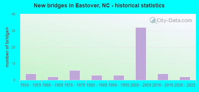
- New bridges - historical statistics
- 41950-1959
- 21960-1969
- 61970-1979
- 31980-1989
- 31990-1999
- 322000-2009
- 42010-2019
- 22020-2022
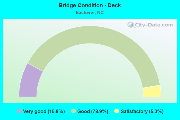
- Bridge Condition - Deck
- 15.8%Very good
- 78.9%Good
- 5.3%Satisfactory
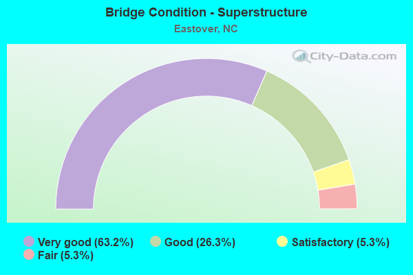
- Bridge Condition - Superstructure
- 63.2%Very good
- 26.3%Good
- 5.3%Satisfactory
- 5.3%Fair
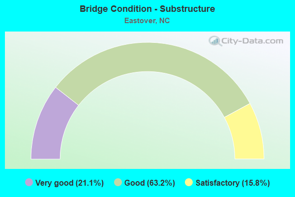
- Bridge Condition - Substructure
- 21.1%Very good
- 63.2%Good
- 15.8%Satisfactory
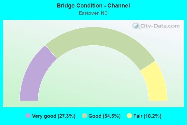
- Bridge Condition - Channel
- 27.3%Very good
- 54.5%Good
- 18.2%Fair
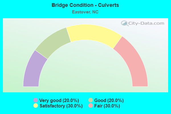
- Bridge Condition - Culverts
- 20.0%Very good
- 20.0%Good
- 30.0%Satisfactory
- 30.0%Fair
Find on map >> Show street view
Structure Number: 510013, Location: 0.6 MI. N. JCT. US 301 (Lat: 35.123183, Lng: -78.754133), Route carried "on" structure: State highway 295, Year Built: 2005, Status: Open, Structure Length: 7.22m (23.69ft), Average Daily Traffic: 10,750 (year 2019), Truck Traffic: 8%, Average Future Daily Traffic: 21,500 (year 2040), Design Load: HS 20+Mod, Features Intersected: I95
Minimum Vertical Clearance: 30+ m (98+ ft), Kilometerpoint: 0.000, Lanes on structure: 2, Lanes under structure: 8, Base Highway Network: Yes (Inventory Route: 3, Subroute: 95), Owner: State Highway Agency, Approaching Roadway Width: 9.1m (29.9ft), Skew: 12 degrees, Material/Design: Steel continuous, Design/Construction: Stringer/Multi-beam, Number Of Spans In Main Unit: 2, Length of Maximum Span: 35.6m (116.8ft), Curb-To-Curb Width: 14.3m (46.9ft), Out-to-Out Width: 15.3m (50.2ft)
Condition: Deck: Satisfactory, Superstructure: Good, Substructure: Good, Operating Rating: 89.8 metric tons, Method Used To Determine Operating Rating: Load Factor (LF), Inventory Rating: 80.7 metric tons, Method Used To Determine Inventory Rating: Load Factor (LF), Structural Evaluation: Better than present minimum criteria, Deck Geometry: Superior to present desirable criteria, Underclear: High priority of corrective action, Approach Roadway Alignment: Equal to present desirable criteria, Designated Inspection Frequency: Every 24 months, Inspection Date: March 2021, Deck Structure Type: Concrete Cast-file-Place, Wearing Surface/Protective System: Wearing Surface: Monolithic Concrete, Deck Protection: Epoxy Coated Reinforcing
Find on map >> Show street view
Structure Number: 510062, Location: 0.7 MI. S. JCT. US301 (Lat: 35.093419, Lng: -78.772133), Route carried "on" structure: State highway 1828, Year Built: 1983, Status: Open, Structure Length: 0.67m (2.20ft), Average Daily Traffic: 2,800 (year 2018), Truck Traffic: 6%, Average Future Daily Traffic: 5,600 (year 2040), Design Load: HS 20+Mod, Features Intersected: BAKERS SWAMP
Minimum Vertical Clearance: 30+ m (98+ ft), Kilometerpoint: 0.000, Lanes on structure: 2, Owner: State Highway Agency, Approaching Roadway Width: 7.3m (24.0ft), Material/Design: Aluminum, Iron, Design/Construction: Culvert, Number Of Spans In Main Unit: 2, Length of Maximum Span: 3.0m (9.8ft)
Condition: Channel: Good, Culverts: Good, Operating Rating: 89.8 metric tons, Method Used To Determine Operating Rating: Load and Resistance Factor (LRFR), Inventory Rating: 89.8 metric tons, Method Used To Determine Inventory Rating: Load and Resistance Factor (LRFR), Structural Evaluation: Better than present minimum criteria, Waterway Adequacy: Better than present minimum criteria, Approach Roadway Alignment: Equal to present desirable criteria, Designated Inspection Frequency: Every 24 months, Underwater Inspection Frequency: Every 60 months, Inspection Date: November 2021, Underwater Inspection Date: November 2021
Find on map >> Show street view
Structure Number: 510082, Location: 0.1 MI S. OF JCT SR2818 (Lat: 35.075647, Lng: -78.834964), Route carried "on" structure: State highway 1728, Year Built: 1994, Status: Open, Structure Length: 1.85m (6.07ft), Average Daily Traffic: 1,800 (year 2018), Truck Traffic: 7%, Average Future Daily Traffic: 3,600 (year 2040), Design Load: HS 20+Mod, Features Intersected: LOCKS CREEK
Minimum Vertical Clearance: 30+ m (98+ ft), Kilometerpoint: 0.000, Lanes on structure: 2, Owner: State Highway Agency, Approaching Roadway Width: 7.3m (24.0ft), Skew: 4 degrees, Material/Design: Concrete continuous, Design/Construction: Culvert, Number Of Spans In Main Unit: 3, Length of Maximum Span: 4.2m (13.8ft)
Condition: Channel: Good, Culverts: Satisfactory, Operating Rating: 56.2 metric tons, Method Used To Determine Operating Rating: Load and Resistance Factor (LRFR), Inventory Rating: 43.5 metric tons, Method Used To Determine Inventory Rating: Load and Resistance Factor (LRFR), Structural Evaluation: Equal to present minimum criteria, Waterway Adequacy: Better than present minimum criteria, Approach Roadway Alignment: Equal to present desirable criteria, Designated Inspection Frequency: Every 24 months, Inspection Date: January 2021
Find on map >> Show street view
Structure Number: 510087, Location: .4 MI.E. OF JCT.SR1721 (Lat: 35.111958, Lng: -78.790914), Route carried "on" structure: State highway 1722, Year Built: 2017, Status: Open, Structure Length: 0.64m (2.10ft), Average Daily Traffic: 1,300 (year 2016), Truck Traffic: 6%, Average Future Daily Traffic: 2,600 (year 2025), Design Load: HL 93, Features Intersected: GUM LOG CANAL
Minimum Vertical Clearance: 30+ m (98+ ft), Kilometerpoint: 0.000, Lanes on structure: 2, Owner: State Highway Agency, Approaching Roadway Width: 6.7m (22.0ft), Material/Design: Aluminum, Iron, Design/Construction: Culvert, Number Of Spans In Main Unit: 1, Length of Maximum Span: 2.4m (7.9ft)
Condition: Channel: Very good, Culverts: Very good, Operating Rating: 58.0 metric tons, Method Used To Determine Operating Rating: Load and Resistance Factor (LRFR), Inventory Rating: 58.0 metric tons, Method Used To Determine Inventory Rating: Load and Resistance Factor (LRFR), Structural Evaluation: Equal to present desirable criteria, Waterway Adequacy: Better than present minimum criteria, Approach Roadway Alignment: Equal to present desirable criteria, Designated Inspection Frequency: Every 24 months, Inspection Date: May 2021
Find on map >> Show street view
Structure Number: 510088, Location: 0.1MI. W. JCT. SR1725 (Lat: 35.117367, Lng: -78.810325), Route carried "on" structure: State highway 1722, Year Built: 1983, Status: Open, Structure Length: 0.70m (2.30ft), Average Daily Traffic: 740 (year 2016), Truck Traffic: 6%, Average Future Daily Traffic: 1,480 (year 2040), Design Load: HS 20+Mod, Features Intersected: FLAT SWAMP DITCH
Minimum Vertical Clearance: 30+ m (98+ ft), Kilometerpoint: 0.000, Lanes on structure: 2, Owner: State Highway Agency, Approaching Roadway Width: 7.3m (24.0ft), Material/Design: Steel, Design/Construction: Culvert, Number Of Spans In Main Unit: 2, Length of Maximum Span: 3.0m (9.8ft)
Condition: Channel: Very good, Culverts: Satisfactory, Operating Rating: 89.8 metric tons, Method Used To Determine Operating Rating: Load and Resistance Factor (LRFR), Inventory Rating: 89.8 metric tons, Method Used To Determine Inventory Rating: Load and Resistance Factor (LRFR), Structural Evaluation: Equal to present minimum criteria, Waterway Adequacy: Equal to present minimum criteria, Approach Roadway Alignment: Equal to present desirable criteria, Designated Inspection Frequency: Every 24 months, Underwater Inspection Frequency: Every 60 months, Inspection Date: October 2021, Underwater Inspection Date: October 2021
Find on map >> Show street view
Structure Number: 510089, Location: 0.1 MI.N.JCT SR1721 (Lat: 35.127500, Lng: -78.797444), Route carried "on" structure: State highway 1720, Year Built: 1985, Status: Open, Structure Length: 0.64m (2.10ft), Average Daily Traffic: 140 (year 2010), Truck Traffic: 6%, Average Future Daily Traffic: 280 (year 2025), Design Load: HS 20+Mod, Features Intersected: GUM LOG CANAL
Minimum Vertical Clearance: 30+ m (98+ ft), Kilometerpoint: 0.000, Lanes on structure: 2, Owner: State Highway Agency, Approaching Roadway Width: 6.0m (19.7ft), Skew: 3 degrees, Material/Design: Steel, Design/Construction: Culvert, Number Of Spans In Main Unit: 2, Length of Maximum Span: 2.7m (8.9ft)
Condition: Channel: Fair, Culverts: Fair, Operating Rating: 89.8 metric tons, Method Used To Determine Operating Rating: Load and Resistance Factor (LRFR), Inventory Rating: 89.8 metric tons, Method Used To Determine Inventory Rating: Load and Resistance Factor (LRFR), Structural Evaluation: Somewhat better than minimum adequacy, Waterway Adequacy: Better than present minimum criteria, Approach Roadway Alignment: Equal to present desirable criteria, Designated Inspection Frequency: Every 24 months, Underwater Inspection Frequency: Every 60 months, Inspection Date: April 2020, Underwater Inspection Date: April 2020
Find on map >> Show street view
Structure Number: 510094, Location: 60 FT.W.JCT.SR1719 (Lat: 35.141781, Lng: -78.813894), Route carried "on" structure: State highway 1720, Year Built: 1993, Status: Open, Structure Length: 0.70m (2.30ft), Average Daily Traffic: 100 (year 1998), Truck Traffic: 6%, Average Future Daily Traffic: 200 (year 2040), Design Load: HS 20+Mod, Features Intersected: CREEK
Minimum Vertical Clearance: 30+ m (98+ ft), Kilometerpoint: 0.000, Lanes on structure: 2, Owner: State Highway Agency, Approaching Roadway Width: 7.3m (24.0ft), Skew: 1 degrees, Material/Design: Steel, Design/Construction: Culvert, Number Of Spans In Main Unit: 2, Length of Maximum Span: 3.3m (10.8ft)
Condition: Channel: Fair, Culverts: Fair, Operating Rating: 89.8 metric tons, Method Used To Determine Operating Rating: Load and Resistance Factor (LRFR), Inventory Rating: 89.8 metric tons, Method Used To Determine Inventory Rating: Load and Resistance Factor (LRFR), Structural Evaluation: Somewhat better than minimum adequacy, Waterway Adequacy: Better than present minimum criteria, Approach Roadway Alignment: Equal to present desirable criteria, Designated Inspection Frequency: Every 24 months, Underwater Inspection Frequency: Every 60 months, Inspection Date: November 2021, Underwater Inspection Date: November 2021
Find on map >> Show street view
Structure Number: 510127, Location: 0.2 MI.N. JCT.SR1838 (Lat: 35.076572, Lng: -78.814667), Route carried "on" structure: State highway 1725, Year Built: 1957, Status: Open, Structure Length: 6.82m (22.38ft), Average Daily Traffic: 1,000 (year 2016), Truck Traffic: 6%, Average Future Daily Traffic: 2,000 (year 2040), Design Load: HS 15, Features Intersected: I95BUS,US301
Minimum Vertical Clearance: 30+ m (98+ ft), Kilometerpoint: 0.000, Lanes on structure: 2, Lanes under structure: 4, Owner: State Highway Agency, Approaching Roadway Width: 7.9m (25.9ft), Skew: 2 degrees, Material/Design: Steel, Design/Construction: Stringer/Multi-beam, Number Of Spans In Main Unit: 4, Length of Maximum Span: 17.6m (57.7ft), Curb or Sidewalk Widths: Left: 0.4m (1.3ft), Right: 0.4m (1.3ft), Curb-To-Curb Width: 8.5m (27.9ft), Out-to-Out Width: 10.2m (33.5ft)
Condition: Deck: Good, Superstructure: Fair, Substructure: Satisfactory, Operating Rating: 41.7 metric tons, Method Used To Determine Operating Rating: Load Factor (LF), Inventory Rating: 25.4 metric tons, Method Used To Determine Inventory Rating: Load Factor (LF), Structural Evaluation: Somewhat better than minimum adequacy, Deck Geometry: Somewhat better than minimum adequacy, Underclear: Meets minimum limits, Approach Roadway Alignment: Equal to present desirable criteria, Designated Inspection Frequency: Every 24 months, Inspection Date: January 2022, Deck Structure Type: Concrete Cast-file-Place, Wearing Surface/Protective System: Wearing Surface: Monolithic Concrete
Find on map >> Show street view
Structure Number: 510129, Location: 0.5 MI.S. JCT. I-95S (Lat: 35.087661, Lng: -78.790450), Route carried "on" structure: Business Interstate 95, Year Built: 2019, Status: Open, Structure Length: 3.01m (9.88ft), Average Daily Traffic: 5,000 (year 2016), Truck Traffic: 12%, Average Future Daily Traffic: 10,000 (year 2040), Design Load: HL 93, Features Intersected: US301
Minimum Vertical Clearance: 30+ m (98+ ft), Kilometerpoint: 0.000, Lanes on structure: 2, Lanes under structure: 2, Owner: State Highway Agency, Approaching Roadway Width: 11.5m (37.7ft), Skew: 14 degrees, Material/Design: Steel, Design/Construction: Slab, Number Of Spans In Main Unit: 1, Length of Maximum Span: 28.0m (91.9ft), Curb-To-Curb Width: 11.5m (37.7ft), Out-to-Out Width: 12.2m (40.0ft)
Condition: Deck: Very good, Superstructure: Very good, Substructure: Very good, Operating Rating: 89.8 metric tons, Method Used To Determine Operating Rating: Load and Resistance Factor (LRFR), Inventory Rating: 73.4 metric tons, Method Used To Determine Inventory Rating: Load and Resistance Factor (LRFR), Structural Evaluation: Equal to present desirable criteria, Deck Geometry: Somewhat better than minimum adequacy, Underclear: Meets minimum limits, Approach Roadway Alignment: Equal to present desirable criteria, Designated Inspection Frequency: Every 24 months, Inspection Date: January 2022, Deck Structure Type: Concrete Cast-file-Place, Wearing Surface/Protective System: Wearing Surface: Monolithic Concrete
Find on map >> Show street view
Structure Number: 51013, Location: 0.5 MI S. OF JCT I95-S (Lat: 35.087875, Lng: -78.790294), Route carried "on" structure: Business Interstate 95, Year Built: 2020, Status: Open, Structure Length: 3.01m (9.88ft), Average Daily Traffic: 5,000 (year 2016), Truck Traffic: 14%, Average Future Daily Traffic: 10,000 (year 2040), Design Load: HL 93, Features Intersected: US301
Minimum Vertical Clearance: 30+ m (98+ ft), Kilometerpoint: 0.000, Lanes on structure: 2, Lanes under structure: 2, Base Highway Network: Yes, Owner: State Highway Agency, Approaching Roadway Width: 11.5m (37.7ft), Skew: 14 degrees, Material/Design: Steel, Design/Construction: Slab, Number Of Spans In Main Unit: 1, Length of Maximum Span: 28.0m (91.9ft), Curb-To-Curb Width: 11.5m (37.7ft), Out-to-Out Width: 12.2m (40.0ft)
Condition: Deck: Very good, Superstructure: Very good, Substructure: Very good, Operating Rating: 89.8 metric tons, Method Used To Determine Operating Rating: Load and Resistance Factor (LRFR), Inventory Rating: 73.4 metric tons, Method Used To Determine Inventory Rating: Load and Resistance Factor (LRFR), Structural Evaluation: Equal to present desirable criteria, Deck Geometry: Somewhat better than minimum adequacy, Underclear: Meets minimum limits, Approach Roadway Alignment: Equal to present desirable criteria, Designated Inspection Frequency: Every 24 months, Inspection Date: January 2022, Deck Structure Type: Concrete Cast-file-Place, Wearing Surface/Protective System: Wearing Surface: Monolithic Concrete
Find on map >> Show street view
Structure Number: 510142, Location: 0.4 MI. N. OF JCT. US301 (Lat: 35.088742, Lng: -78.782961), Route carried "on" structure: Business Interstate 95, Year Built: 1979, Status: Open, Structure Length: 12.49m (40.98ft), Average Daily Traffic: 5,000 (year 2016), Truck Traffic: 14%, Average Future Daily Traffic: 10,000 (year 2040), Design Load: HS 20+Mod, Features Intersected: I95
Minimum Vertical Clearance: 30+ m (98+ ft), Kilometerpoint: 0.000, Lanes on structure: 2, Lanes under structure: 4, Base Highway Network: Yes (Inventory Route: 1, Subroute: 95), Owner: State Highway Agency, Approaching Roadway Width: 9.1m (29.9ft), Skew: 4 degrees, Material/Design: Steel, Design/Construction: Stringer/Multi-beam, Number Of Spans In Main Unit: 4, Length of Maximum Span: 47.5m (155.8ft), Curb-To-Curb Width: 12.2m (40.0ft), Out-to-Out Width: 13.1m (43.0ft)
Condition: Deck: Very good, Superstructure: Good, Substructure: Satisfactory, Operating Rating: 89.8 metric tons, Method Used To Determine Operating Rating: Load Factor (LF), Inventory Rating: 64.4 metric tons, Method Used To Determine Inventory Rating: Load Factor (LF), Structural Evaluation: Equal to present minimum criteria, Deck Geometry: Better than present minimum criteria, Underclear: Equal to present minimum criteria, Approach Roadway Alignment: Equal to present desirable criteria, Designated Inspection Frequency: Every 24 months, Inspection Date: December 2021, Deck Structure Type: Concrete Cast-file-Place, Wearing Surface/Protective System: Wearing Surface: Monolithic Concrete
Find on map >> Show street view
Structure Number: 510147, Location: 0.4 MI.E.JCT.SR1838 (Lat: 35.082728, Lng: -78.786558), Route carried "on" structure: State highway 1832, Year Built: 1979, Status: Open, Structure Length: 7.95m (26.08ft), Average Daily Traffic: 4,700 (year 2016), Truck Traffic: 6%, Average Future Daily Traffic: 9,400 (year 2040), Design Load: HS 20+Mod, Features Intersected: I95
Minimum Vertical Clearance: 30+ m (98+ ft), Kilometerpoint: 0.000, Lanes on structure: 2, Lanes under structure: 4, Owner: State Highway Agency, Approaching Roadway Width: 14.9m (48.9ft), Skew: 1 degrees, Material/Design: Steel, Design/Construction: Stringer/Multi-beam, Number Of Spans In Main Unit: 2, Length of Maximum Span: 39.0m (128.0ft), Curb-To-Curb Width: 20.7m (67.9ft), Out-to-Out Width: 21.5m (70.5ft)
Condition: Deck: Good, Superstructure: Satisfactory, Substructure: Satisfactory, Operating Rating: 89.8 metric tons, Method Used To Determine Operating Rating: Load Factor (LF), Inventory Rating: 70.7 metric tons, Method Used To Determine Inventory Rating: Load Factor (LF), Structural Evaluation: Equal to present minimum criteria, Deck Geometry: Superior to present desirable criteria, Underclear: Equal to present minimum criteria, Approach Roadway Alignment: Equal to present desirable criteria, Designated Inspection Frequency: Every 24 months, Inspection Date: December 2021, Deck Structure Type: Concrete Cast-file-Place, Wearing Surface/Protective System: Wearing Surface: Latex Concrete
Find on map >> Show street view
Structure Number: 51019, Location: 0.3 MI.W. OF JCT.SR1728 (Lat: 35.088961, Lng: -78.827244), Route carried "on" structure: State highway 1730, Year Built: 1999, Status: Open, Structure Length: 1.88m (6.17ft), Average Daily Traffic: 340 (year 2018), Truck Traffic: 6%, Average Future Daily Traffic: 680 (year 2040), Design Load: HS 20+Mod, Features Intersected: GUM LOG CANAL
Minimum Vertical Clearance: 30+ m (98+ ft), Kilometerpoint: 0.000, Lanes on structure: 2, Owner: State Highway Agency, Approaching Roadway Width: 6.7m (22.0ft), Skew: 3 degrees, Material/Design: Prestressed concrete, Design/Construction: Slab, Number Of Spans In Main Unit: 2, Length of Maximum Span: 8.8m (28.9ft), Curb-To-Curb Width: 8.2m (26.9ft), Out-to-Out Width: 9.1m (29.9ft)
Condition: Deck: Good, Superstructure: Good, Substructure: Good, Channel: Good, Operating Rating: 89.8 metric tons, Method Used To Determine Operating Rating: Load Factor (LF), Inventory Rating: 74.3 metric tons, Method Used To Determine Inventory Rating: Load Factor (LF), Structural Evaluation: Better than present minimum criteria, Deck Geometry: Somewhat better than minimum adequacy, Waterway Adequacy: Better than present minimum criteria, Approach Roadway Alignment: Equal to present desirable criteria, Designated Inspection Frequency: Every 24 months, Inspection Date: March 2021, Deck Structure Type: Concrete Precast Panels, Wearing Surface/Protective System: Wearing Surface: Bituminous
Find on map >> Show street view
Structure Number: 510212, Location: .1 MI.N.JCT.SR1835 (Lat: 35.080556, Lng: -78.795769), Route carried "on" structure: State highway 1838, Year Built: 2010, Status: Open, Structure Length: 1.24m (4.07ft), Average Daily Traffic: 3,500 (year 2018), Truck Traffic: 8%, Average Future Daily Traffic: 7,000 (year 2040), Design Load: HS 20+Mod, Features Intersected: REESE CREEK
Minimum Vertical Clearance: 30+ m (98+ ft), Kilometerpoint: 0.000, Lanes on structure: 2, Base Highway Network: Yes, Owner: State Highway Agency, Approaching Roadway Width: 8.5m (27.9ft), Skew: 1 degrees, Material/Design: Aluminum, Iron, Design/Construction: Culvert, Number Of Spans In Main Unit: 1, Length of Maximum Span: 10.3m (33.8ft)
Condition: Channel: Very good, Culverts: Very good, Operating Rating: 24.4 metric tons, Method Used To Determine Operating Rating: Load and Resistance Factor (LRFR), Inventory Rating: 24.4 metric tons, Method Used To Determine Inventory Rating: Load and Resistance Factor (LRFR), Structural Evaluation: Equal to present minimum criteria, Waterway Adequacy: Equal to present desirable criteria, Approach Roadway Alignment: Equal to present desirable criteria, Designated Inspection Frequency: Every 24 months, Inspection Date: August 2021
Find on map >> Show street view
Structure Number: 510242, Location: 100' S. OF JCT.SR1797 (Lat: 35.099294, Lng: -78.809708), Route carried "on" structure: State highway 1725, Year Built: 1960, Status: Open, Structure Length: 0.64m (2.10ft), Average Daily Traffic: 340 (year 2016), Truck Traffic: 6%, Average Future Daily Traffic: 680 (year 2040), Design Load: HS 20+Mod, Features Intersected: GUM LOG CANAL
Minimum Vertical Clearance: 30+ m (98+ ft), Kilometerpoint: 0.000, Lanes on structure: 2, Owner: State Highway Agency, Approaching Roadway Width: 6.0m (19.7ft), Skew: 4 degrees, Material/Design: Steel, Design/Construction: Culvert, Number Of Spans In Main Unit: 1, Length of Maximum Span: 4.5m (14.8ft)
Condition: Channel: Good, Culverts: Fair, Operating Rating: 89.8 metric tons, Method Used To Determine Operating Rating: Load and Resistance Factor (LRFR), Inventory Rating: 89.8 metric tons, Method Used To Determine Inventory Rating: Load and Resistance Factor (LRFR), Structural Evaluation: Somewhat better than minimum adequacy, Waterway Adequacy: Better than present minimum criteria, Approach Roadway Alignment: Equal to present desirable criteria, Designated Inspection Frequency: Every 24 months, Inspection Date: March 2021
Find on map >> Show street view
Structure Number: 510243, Location: 0.1 MI. N. JCT. US30 (Lat: 35.078661, Lng: -78.815006), Route carried "on" structure: State highway 1725, Year Built: 1965, Status: Open, Structure Length: 0.76m (2.49ft), Average Daily Traffic: 900 (year 2012), Truck Traffic: 6%, Average Future Daily Traffic: 1,800 (year 2040), Design Load: HS 20+Mod, Features Intersected: LOCKS CREEK
Minimum Vertical Clearance: 30+ m (98+ ft), Kilometerpoint: 0.000, Lanes on structure: 2, Owner: State Highway Agency, Approaching Roadway Width: 7.3m (24.0ft), Material/Design: Concrete continuous, Design/Construction: Culvert, Number Of Spans In Main Unit: 2, Length of Maximum Span: 3.6m (11.8ft)
Condition: Channel: Good, Culverts: Good, Operating Rating: 41.7 metric tons, Method Used To Determine Operating Rating: Load Factor (LF), Inventory Rating: 32.6 metric tons, Method Used To Determine Inventory Rating: Load Factor (LF), Structural Evaluation: Better than present minimum criteria, Waterway Adequacy: Better than present minimum criteria, Approach Roadway Alignment: Equal to present desirable criteria, Designated Inspection Frequency: Every 24 months, Inspection Date: October 2021
Find on map >> Show street view
Structure Number: 510248, Location: 0.6 MI N. JCT. SR1725 (Lat: 35.081219, Lng: -78.805986), Route carried "on" structure: Business Interstate 95, Year Built: 1958, Status: Open, Structure Length: 0.73m (2.40ft), Average Daily Traffic: 9,900 (year 2019), Truck Traffic: 14%, Average Future Daily Traffic: 19,800 (year 2040), Design Load: HS 20+Mod, Features Intersected: REESE CREEK
Minimum Vertical Clearance: 30+ m (98+ ft), Kilometerpoint: 0.000, Lanes on structure: 4, Base Highway Network: Yes (Inventory Route: 1, Subroute: 95), Owner: State Highway Agency, Approaching Roadway Width: 21.9m (71.9ft), Skew: 2 degrees, Material/Design: Concrete continuous, Design/Construction: Culvert, Number Of Spans In Main Unit: 2, Length of Maximum Span: 3.3m (10.8ft)
Condition: Channel: Good, Culverts: Satisfactory, Operating Rating: 41.7 metric tons, Method Used To Determine Operating Rating: Field evaluation and documented engineering judgment, Inventory Rating: 32.6 metric tons, Method Used To Determine Inventory Rating: Field evaluation and documented engineering judgment, Structural Evaluation: Equal to present minimum criteria, Waterway Adequacy: Better than present minimum criteria, Approach Roadway Alignment: Equal to present desirable criteria, Designated Inspection Frequency: Every 24 months, Inspection Date: October 2021
Find on map >> Show street view
Structure Number: 510303, Location: .3 MI. S. OF JCT. US13 (Lat: 35.119689, Lng: -78.757775), Route carried "on" structure: State highway 1933, Year Built: 2001, Status: Open, Structure Length: 18.07m (59.28ft), Average Daily Traffic: 1,400 (year 2016), Truck Traffic: 6%, Average Future Daily Traffic: 2,800 (year 2040), Design Load: HS 20+Mod, Features Intersected: I-95, I-95S.RMP
Minimum Vertical Clearance: 30+ m (98+ ft), Kilometerpoint: 0.000, Lanes on structure: 2, Lanes under structure: 6, Owner: State Highway Agency, Approaching Roadway Width: 11.5m (37.7ft), Skew: 4 degrees, Material/Design: Steel, Design/Construction: Stringer/Multi-beam, Number Of Spans In Main Unit: 4, Length of Maximum Span: 50.9m (167.0ft), Curb-To-Curb Width: 11.6m (38.1ft), Out-to-Out Width: 12.7m (41.7ft)
Condition: Deck: Good, Superstructure: Good, Substructure: Good, Operating Rating: 45.3 metric tons, Method Used To Determine Operating Rating: Load Factor (LF), Inventory Rating: 27.2 metric tons, Method Used To Determine Inventory Rating: Load Factor (LF), Structural Evaluation: Equal to present minimum criteria, Deck Geometry: Equal to present minimum criteria, Underclear: High priority of corrective action, Approach Roadway Alignment: Equal to present desirable criteria, Designated Inspection Frequency: Every 24 months, Inspection Date: March 2021, Deck Structure Type: Concrete Cast-file-Place, Wearing Surface/Protective System: Wearing Surface: Monolithic Concrete, Deck Protection: Epoxy Coated Reinforcing
Find on map >> Show street view
Structure Number: 510331, Location: 1 MI. N. SR1714 (Lat: 35.144206, Lng: -78.808586), Route carried "on" structure: Interstate 295, Year Built: 2003, Status: Open, Structure Length: 4.08m (13.39ft), Average Daily Traffic: 10,750 (year 2019), Truck Traffic: 23%, Average Future Daily Traffic: 21,500 (year 2040), Design Load: HS 25 or greater, Features Intersected: SR1719
Minimum Vertical Clearance: 30+ m (98+ ft), Kilometerpoint: 9.570, Lanes on structure: 2, Lanes under structure: 2, Base Highway Network: Yes (Inventory Route: 1, Subroute: 95), Owner: State Highway Agency, Approaching Roadway Width: 10.9m (35.8ft), Skew: 14 degrees, Material/Design: Steel, Design/Construction: Stringer/Multi-beam, Number Of Spans In Main Unit: 1, Length of Maximum Span: 40.2m (131.9ft), Curb-To-Curb Width: 11.3m (37.1ft), Out-to-Out Width: 12.3m (40.4ft)
Condition: Deck: Good, Superstructure: Very good, Substructure: Good, Operating Rating: 86.1 metric tons, Method Used To Determine Operating Rating: Load Factor (LF), Inventory Rating: 51.7 metric tons, Method Used To Determine Inventory Rating: Load Factor (LF), Structural Evaluation: Better than present minimum criteria, Deck Geometry: Somewhat better than minimum adequacy, Underclear: Somewhat better than minimum adequacy, Approach Roadway Alignment: Equal to present desirable criteria, Designated Inspection Frequency: Every 24 months, Inspection Date: Febuary 2021, Deck Structure Type: Concrete Cast-file-Place, Wearing Surface/Protective System: Wearing Surface: Monolithic Concrete, Deck Protection: Epoxy Coated Reinforcing
Find on map >> Show street view
Structure Number: 510332, Location: 1 MI.N. JCT. SR1714 (Lat: 35.144061, Lng: -78.808872), Route carried "on" structure: Interstate 295, Year Built: 2003, Status: Open, Structure Length: 4.08m (13.39ft), Average Daily Traffic: 10,750 (year 2019), Truck Traffic: 23%, Average Future Daily Traffic: 21,500 (year 2040), Design Load: HS 25 or greater, Features Intersected: SR1719
Minimum Vertical Clearance: 30+ m (98+ ft), Kilometerpoint: 9.570, Lanes on structure: 2, Lanes under structure: 2, Base Highway Network: Yes (Inventory Route: 1, Subroute: 95), Owner: State Highway Agency, Approaching Roadway Width: 11.2m (36.7ft), Skew: 14 degrees, Material/Design: Steel, Design/Construction: Stringer/Multi-beam, Number Of Spans In Main Unit: 1, Number Of Approach Spans: 2, Length of Maximum Span: 40.2m (131.9ft), Curb-To-Curb Width: 11.3m (37.1ft), Out-to-Out Width: 12.3m (40.4ft)
Condition: Deck: Good, Superstructure: Very good, Substructure: Good, Operating Rating: 86.1 metric tons, Method Used To Determine Operating Rating: Load Factor (LF), Inventory Rating: 51.7 metric tons, Method Used To Determine Inventory Rating: Load Factor (LF), Structural Evaluation: Better than present minimum criteria, Deck Geometry: Somewhat better than minimum adequacy, Underclear: Somewhat better than minimum adequacy, Approach Roadway Alignment: Equal to present desirable criteria, Designated Inspection Frequency: Every 24 months, Inspection Date: Febuary 2021, Deck Structure Type: Concrete Cast-file-Place, Wearing Surface/Protective System: Wearing Surface: Monolithic Concrete, Deck Protection: Epoxy Coated Reinforcing
Find on map >> Show street view
Structure Number: 510333, Location: 2 MI. S. JCT. I-95 (Lat: 35.137142, Lng: -78.786006), Route carried "on" structure: State highway 295, Year Built: 2003, Status: Open, Structure Length: 2.98m (9.78ft), Average Daily Traffic: 10,000 (year 2017), Truck Traffic: 14%, Average Future Daily Traffic: 20,000 (year 2040), Design Load: HS 25 or greater, Features Intersected: SR1721
Minimum Vertical Clearance: 30+ m (98+ ft), Kilometerpoint: 0.000, Lanes on structure: 2, Lanes under structure: 2, Base Highway Network: Yes (Inventory Route: 3, Subroute: 95), Owner: State Highway Agency, Approaching Roadway Width: 10.6m (34.8ft), Skew: 10 degrees, Material/Design: Steel continuous, Design/Construction: Stringer/Multi-beam, Number Of Spans In Main Unit: 1, Length of Maximum Span: 28.6m (93.8ft), Curb-To-Curb Width: 11.3m (37.1ft), Out-to-Out Width: 12.3m (40.4ft)
Condition: Deck: Good, Superstructure: Very good, Substructure: Good, Operating Rating: 89.8 metric tons, Method Used To Determine Operating Rating: Load Factor (LF), Inventory Rating: 44.4 metric tons, Method Used To Determine Inventory Rating: Load Factor (LF), Structural Evaluation: Better than present minimum criteria, Deck Geometry: Equal to present minimum criteria, Underclear: Equal to present minimum criteria, Approach Roadway Alignment: Equal to present desirable criteria, Designated Inspection Frequency: Every 24 months, Inspection Date: March 2021, Deck Structure Type: Concrete Cast-file-Place, Wearing Surface/Protective System: Wearing Surface: Monolithic Concrete, Deck Protection: Epoxy Coated Reinforcing
Find on map >> Show street view
Structure Number: 510334, Location: 2 MI. S. OF JCT. I-95 (Lat: 35.136978, Lng: -78.786131), Route carried "on" structure: State highway 295, Year Built: 2003, Status: Open, Structure Length: 2.95m (9.68ft), Average Daily Traffic: 10,000 (year 2017), Truck Traffic: 14%, Average Future Daily Traffic: 20,000 (year 2040), Design Load: HS 25 or greater, Features Intersected: SR1721
Minimum Vertical Clearance: 30+ m (98+ ft), Kilometerpoint: 0.000, Lanes on structure: 2, Lanes under structure: 2, Base Highway Network: Yes (Inventory Route: 3, Subroute: 95), Owner: State Highway Agency, Approaching Roadway Width: 10.9m (35.8ft), Skew: 10 degrees, Material/Design: Prestressed concrete, Design/Construction: Stringer/Multi-beam, Number Of Spans In Main Unit: 1, Length of Maximum Span: 28.0m (91.9ft), Curb-To-Curb Width: 11.4m (37.4ft), Out-to-Out Width: 12.3m (40.4ft)
Condition: Deck: Good, Superstructure: Very good, Substructure: Very good, Operating Rating: 89.8 metric tons, Method Used To Determine Operating Rating: Load Factor (LF), Inventory Rating: 48.0 metric tons, Method Used To Determine Inventory Rating: Load Factor (LF), Structural Evaluation: Equal to present desirable criteria, Deck Geometry: Equal to present minimum criteria, Underclear: Equal to present minimum criteria, Approach Roadway Alignment: Equal to present desirable criteria, Designated Inspection Frequency: Every 24 months, Inspection Date: March 2021, Deck Structure Type: Concrete Cast-file-Place, Wearing Surface/Protective System: Wearing Surface: Monolithic Concrete, Deck Protection: Epoxy Coated Reinforcing
Find on map >> Show street view
Structure Number: 510335, Location: 1.3 MI. S. OF JCT. I-95 (Lat: 35.132772, Lng: -78.776531), Route carried "on" structure: State highway 295, Year Built: 2003, Status: Open, Structure Length: 5.02m (16.47ft), Average Daily Traffic: 10,000 (year 2017), Truck Traffic: 14%, Average Future Daily Traffic: 20,000 (year 2040), Design Load: HS 25 or greater, Features Intersected: CSX R/R
Minimum Vertical Clearance: 30+ m (98+ ft), Kilometerpoint: 10.180, Lanes on structure: 2, Base Highway Network: Yes (Inventory Route: 3, Subroute: 95), Owner: State Highway Agency, Approaching Roadway Width: 10.9m (35.8ft), Skew: 11 degrees, Material/Design: Steel, Design/Construction: Stringer/Multi-beam, Number Of Spans In Main Unit: 1, Length of Maximum Span: 49.0m (160.8ft), Curb-To-Curb Width: 11.3m (37.1ft), Out-to-Out Width: 12.3m (40.4ft)
Condition: Deck: Good, Superstructure: Very good, Substructure: Good, Operating Rating: 80.7 metric tons, Method Used To Determine Operating Rating: Load Factor (LF), Inventory Rating: 48.0 metric tons, Method Used To Determine Inventory Rating: Load Factor (LF), Structural Evaluation: Better than present minimum criteria, Deck Geometry: Equal to present minimum criteria, Underclear: Better than present minimum criteria, Approach Roadway Alignment: Equal to present desirable criteria, Designated Inspection Frequency: Every 24 months, Inspection Date: March 2021, Deck Structure Type: Concrete Cast-file-Place, Wearing Surface/Protective System: Wearing Surface: Monolithic Concrete, Deck Protection: Epoxy Coated Reinforcing
Find on map >> Show street view
Structure Number: 510336, Location: 1.3 MI. S. OF JCT. I-95 (Lat: 35.132639, Lng: -78.776706), Route carried "on" structure: State highway 295, Year Built: 2003, Status: Open, Structure Length: 5.02m (16.47ft), Average Daily Traffic: 10,000 (year 2017), Truck Traffic: 14%, Average Future Daily Traffic: 20,000 (year 2040), Design Load: HS 25 or greater, Features Intersected: CSX R/R
Minimum Vertical Clearance: 30+ m (98+ ft), Kilometerpoint: 0.000, Lanes on structure: 2, Base Highway Network: Yes (Inventory Route: 2, Subroute: 95), Owner: State Highway Agency, Approaching Roadway Width: 12.4m (40.7ft), Skew: 11 degrees, Material/Design: Steel, Design/Construction: Stringer/Multi-beam, Number Of Spans In Main Unit: 1, Length of Maximum Span: 49.0m (160.8ft), Curb-To-Curb Width: 11.3m (37.1ft), Out-to-Out Width: 12.3m (40.4ft)
Condition: Deck: Good, Superstructure: Very good, Substructure: Very good, Operating Rating: 79.8 metric tons, Method Used To Determine Operating Rating: Load Factor (LF), Inventory Rating: 48.0 metric tons, Method Used To Determine Inventory Rating: Load Factor (LF), Structural Evaluation: Equal to present desirable criteria, Deck Geometry: Equal to present minimum criteria, Underclear: Equal to present desirable criteria, Approach Roadway Alignment: Equal to present desirable criteria, Designated Inspection Frequency: Every 24 months, Inspection Date: March 2021, Deck Structure Type: Concrete Cast-file-Place, Wearing Surface/Protective System: Wearing Surface: Monolithic Concrete, Deck Protection: Epoxy Coated Reinforcing
Find on map >> Show street view
Structure Number: 510339, Location: 0.4 MI. S. JCT. SR1863 (Lat: 35.125256, Lng: -78.760217), Route carried "on" structure: State highway 295, Year Built: 2005, Status: Open, Structure Length: 3.35m (10.99ft), Average Daily Traffic: 9,200 (year 2018), Truck Traffic: 14%, Average Future Daily Traffic: 18,400 (year 2040), Design Load: HS 25 or greater, Features Intersected: US301
Minimum Vertical Clearance: 30+ m (98+ ft), Kilometerpoint: 10.515, Lanes on structure: 2, Lanes under structure: 2, Base Highway Network: Yes (Inventory Route: 3, Subroute: 95), Owner: State Highway Agency, Approaching Roadway Width: 9.7m (31.8ft), Skew: 10 degrees, Material/Design: Prestressed concrete, Design/Construction: Stringer/Multi-beam, Number Of Spans In Main Unit: 1, Length of Maximum Span: 31.6m (103.7ft), Curb-To-Curb Width: 14.3m (46.9ft), Out-to-Out Width: 15.2m (49.9ft)
Condition: Deck: Good, Superstructure: Very good, Substructure: Good, Operating Rating: 89.8 metric tons, Method Used To Determine Operating Rating: Load Factor (LF), Inventory Rating: 39.9 metric tons, Method Used To Determine Inventory Rating: Load Factor (LF), Structural Evaluation: Better than present minimum criteria, Deck Geometry: Superior to present desirable criteria, Underclear: Equal to present minimum criteria, Approach Roadway Alignment: Equal to present desirable criteria, Designated Inspection Frequency: Every 24 months, Inspection Date: March 2021, Deck Structure Type: Concrete Cast-file-Place, Wearing Surface/Protective System: Wearing Surface: Monolithic Concrete, Deck Protection: Epoxy Coated Reinforcing
Find on map >> Show street view
Structure Number: 51034, Location: 0.4 MI. S. JCT. SR1863 (Lat: 35.125106, Lng: -78.760372), Route carried "on" structure: State highway 295, Year Built: 2005, Status: Open, Structure Length: 3.32m (10.89ft), Average Daily Traffic: 10,000 (year 2017), Truck Traffic: 14%, Average Future Daily Traffic: 20,000 (year 2040), Design Load: HS 25 or greater, Features Intersected: US301
Minimum Vertical Clearance: 30+ m (98+ ft), Kilometerpoint: 10.515, Lanes on structure: 2, Lanes under structure: 2, Base Highway Network: Yes, Owner: State Highway Agency, Approaching Roadway Width: 9.7m (31.8ft), Skew: 10 degrees, Material/Design: Prestressed concrete, Design/Construction: Stringer/Multi-beam, Number Of Spans In Main Unit: 1, Length of Maximum Span: 31.6m (103.7ft), Curb-To-Curb Width: 12.1m (39.7ft), Out-to-Out Width: 13.0m (42.7ft)
Condition: Deck: Good, Superstructure: Very good, Substructure: Good, Operating Rating: 89.8 metric tons, Method Used To Determine Operating Rating: Load Factor (LF), Inventory Rating: 40.8 metric tons, Method Used To Determine Inventory Rating: Load Factor (LF), Structural Evaluation: Better than present minimum criteria, Deck Geometry: Better than present minimum criteria, Underclear: Equal to present minimum criteria, Approach Roadway Alignment: Equal to present desirable criteria, Designated Inspection Frequency: Every 24 months, Inspection Date: March 2021, Deck Structure Type: Concrete Cast-file-Place, Wearing Surface/Protective System: Wearing Surface: Monolithic Concrete, Deck Protection: Epoxy Coated Reinforcing
Find on map >> Show street view
Structure Number: 510341, Location: 0.1 MI.S. OF JCT.I95 (Lat: 35.124850, Lng: -78.760611), Route carried "on" structure: Ramp Interstate 95, Year Built: 2005, Status: Open, Structure Length: 3.20m (10.50ft), Average Daily Traffic: 3,000 (year 2015), Truck Traffic: 23%, Average Future Daily Traffic: 6,000 (year 2040), Design Load: HS 25 or greater, Features Intersected: US301
Minimum Vertical Clearance: 30+ m (98+ ft), Kilometerpoint: 10.515, Lanes on structure: 2, Lanes under structure: 2, Owner: State Highway Agency, Approaching Roadway Width: 11.5m (37.7ft), Skew: 10 degrees, Material/Design: Steel, Design/Construction: Stringer/Multi-beam, Number Of Spans In Main Unit: 1, Length of Maximum Span: 30.4m (99.7ft), Curb-To-Curb Width: 12.3m (40.4ft), Out-to-Out Width: 13.3m (43.6ft)
Condition: Deck: Good, Superstructure: Very good, Substructure: Good, Operating Rating: 89.8 metric tons, Method Used To Determine Operating Rating: Load Factor (LF), Inventory Rating: 59.8 metric tons, Method Used To Determine Inventory Rating: Load Factor (LF), Structural Evaluation: Better than present minimum criteria, Deck Geometry: Superior to present desirable criteria, Underclear: Equal to present minimum criteria, Approach Roadway Alignment: Equal to present desirable criteria, Designated Inspection Frequency: Every 24 months, Inspection Date: March 2021, Deck Structure Type: Concrete Cast-file-Place, Wearing Surface/Protective System: Wearing Surface: Monolithic Concrete, Deck Protection: Epoxy Coated Reinforcing
Find on map >> Show street view
Structure Number: 510342, Location: 0.2MI. S. OF JCT.SR1933 (Lat: 35.123317, Lng: -78.753989), Route carried "on" structure: Ramp Interstate 95, Year Built: 2005, Status: Open, Structure Length: 25.51m (83.69ft), Average Daily Traffic: 28,500 (year 2019), Truck Traffic: 23%, Average Future Daily Traffic: 57,000 (year 2040), Design Load: HS 20+Mod, Features Intersected: I95N,US13
Minimum Vertical Clearance: 30+ m (98+ ft), Kilometerpoint: 17.648, Lanes on structure: 2, Lanes under structure: 10, Owner: State Highway Agency, Approaching Roadway Width: 11.8m (38.7ft), Skew: 1 degrees, Material/Design: Steel continuous, Design/Construction: Stringer/Multi-beam, Number Of Spans In Main Unit: 4, Number Of Approach Spans: 1, Length of Maximum Span: 65.5m (214.9ft), Curb-To-Curb Width: 11.9m (39.0ft), Out-to-Out Width: 12.9m (42.3ft)
Condition: Deck: Good, Superstructure: Good, Substructure: Good, Operating Rating: 89.8 metric tons, Method Used To Determine Operating Rating: Load Factor (LF), Inventory Rating: 68.0 metric tons, Method Used To Determine Inventory Rating: Load Factor (LF), Structural Evaluation: Better than present minimum criteria, Deck Geometry: Superior to present desirable criteria, Underclear: Meets minimum limits, Approach Roadway Alignment: Equal to present desirable criteria, Designated Inspection Frequency: Every 24 months, Inspection Date: March 2021, Deck Structure Type: Concrete Cast-file-Place, Wearing Surface/Protective System: Wearing Surface: Monolithic Concrete, Deck Protection: Epoxy Coated Reinforcing
Find on map >> Show street view
Structure Number: 510344, Location: 0.2 MI. S. OF JCT. SR1933 (Lat: 35.123006, Lng: -78.754319), Route carried "on" structure: US 13, Year Built: 2005, Status: Open, Structure Length: 7.43m (24.38ft), Average Daily Traffic: 7,250 (year 2018), Truck Traffic: 8%, Average Future Daily Traffic: 14,500 (year 2040), Design Load: HS 20+Mod, Features Intersected: I95
Minimum Vertical Clearance: 30+ m (98+ ft), Kilometerpoint: 10.637, Lanes on structure: 2, Lanes under structure: 5, Base Highway Network: Yes (Inventory Route: 2, Subroute: 13), Owner: State Highway Agency, Approaching Roadway Width: 12.1m (39.7ft), Skew: 12 degrees, Material/Design: Steel continuous, Design/Construction: Stringer/Multi-beam, Number Of Spans In Main Unit: 2, Length of Maximum Span: 36.8m (120.7ft), Curb-To-Curb Width: 11.9m (39.0ft), Out-to-Out Width: 12.9m (42.3ft)
Condition: Deck: Good, Superstructure: Very good, Substructure: Good, Operating Rating: 89.8 metric tons, Method Used To Determine Operating Rating: Load Factor (LF), Inventory Rating: 75.2 metric tons, Method Used To Determine Inventory Rating: Load Factor (LF), Structural Evaluation: Better than present minimum criteria, Deck Geometry: Better than present minimum criteria, Underclear: High priority of corrective action, Approach Roadway Alignment: Equal to present desirable criteria, Designated Inspection Frequency: Every 24 months, Inspection Date: March 2021, Deck Structure Type: Concrete Cast-file-Place, Wearing Surface/Protective System: Wearing Surface: Monolithic Concrete, Deck Protection: Epoxy Coated Reinforcing
Find on map >> Show street view
Structure Number: 510013, Location: 0.6 MI. N. JCT. US 301 (Lat: 35.123183, Lng: -78.754133), Route carried "under" structure: Interstate 95, Year Built: 2005, Structure Length: 0. m, Average Daily Traffic: 26,000 (year 2019), Truck Traffic: 23%, Features Intersected: NC295 WBL
Minimum Vertical Clearance: 5.35m (17.55ft), Kilometerpoint: 17.648, Lanes on structure: 2, Lanes under structure: 3, Material/Design: Steel continuous, Design/Construction: Stringer/Multi-beam, Length of Maximum Span: 35.6m (116.8ft)
Find on map >> Show street view
Structure Number: 510013, Location: 0.6 MI. N. JCT. US 301 (Lat: 35.123183, Lng: -78.754133), Route carried "under" structure: Interstate 95, Year Built: 2005, Structure Length: 0. m, Average Daily Traffic: 26,000 (year 2019), Truck Traffic: 23%, Features Intersected: NC295 WBL
Minimum Vertical Clearance: 5.15m (16.90ft), Kilometerpoint: 17.648, Lanes on structure: 2, Lanes under structure: 2, Material/Design: Steel continuous, Design/Construction: Stringer/Multi-beam, Length of Maximum Span: 35.6m (116.8ft)
Find on map >> Show street view
Structure Number: 510013, Location: 0.6 MI. N. JCT. US 301 (Lat: 35.123183, Lng: -78.754133), Route carried "under" structure: Ramp Interstate 295, Year Built: 2005, Structure Length: 0. m, Average Daily Traffic: 7,250 (year 2018), Truck Traffic: 23%, Features Intersected: NC295 WBL
Minimum Vertical Clearance: 5.61m (18.41ft), Kilometerpoint: 0.000, Lanes on structure: 2, Lanes under structure: 3, Material/Design: Steel continuous, Design/Construction: Stringer/Multi-beam, Length of Maximum Span: 35.6m (116.8ft)
Find on map >> Show street view
Structure Number: 510127, Location: 0.2 MI.N. JCT.SR1838 (Lat: 35.076572, Lng: -78.814667), Route carried "under" structure: Business Interstate 95, Year Built: 1957, Structure Length: 0. m, Average Daily Traffic: 4,950 (year 2018), Truck Traffic: 14%, Features Intersected: SR1725
Minimum Vertical Clearance: 5.10m (16.73ft), Kilometerpoint: 0.000, Lanes on structure: 2, Lanes under structure: 2, Material/Design: Steel, Design/Construction: Stringer/Multi-beam, Length of Maximum Span: 17.6m (57.7ft)
Find on map >> Show street view
Structure Number: 510127, Location: 0.2 MI.N. JCT.SR1838 (Lat: 35.076572, Lng: -78.814667), Route carried "under" structure: Business Interstate 95, Year Built: 1957, Structure Length: 0. m, Average Daily Traffic: 4,950 (year 2018), Truck Traffic: 14%, Features Intersected: SR1725
Minimum Vertical Clearance: 5.15m (16.90ft), Kilometerpoint: 0.000, Lanes on structure: 2, Lanes under structure: 2, Material/Design: Steel, Design/Construction: Stringer/Multi-beam, Length of Maximum Span: 17.6m (57.7ft)
Find on map >> Show street view
Structure Number: 510129, Location: 0.5 MI.S. JCT. I-95S (Lat: 35.087661, Lng: -78.790450), Route carried "under" structure: US 301, Year Built: 2019, Structure Length: 0. m, Average Daily Traffic: 3,500 (year 2018), Truck Traffic: 6%, Features Intersected: I-95N.BUS.NBL
Minimum Vertical Clearance: 4.84m (15.88ft), Kilometerpoint: 0.000, Lanes on structure: 2, Lanes under structure: 2, Material/Design: Steel, Design/Construction: Slab, Length of Maximum Span: 28.0m (91.9ft)
Find on map >> Show street view
Structure Number: 51013, Location: 0.5 MI S. OF JCT I95-S (Lat: 35.087875, Lng: -78.790294), Route carried "under" structure: US 301, Year Built: 2020, Structure Length: 0. m, Average Daily Traffic: 3,500 (year 2018), Truck Traffic: 6%, Features Intersected: I95S, BUS.SBL
Minimum Vertical Clearance: 4.92m (16.14ft), Kilometerpoint: 0.000, Lanes on structure: 2, Lanes under structure: 2, Material/Design: Steel, Design/Construction: Slab, Length of Maximum Span: 28.0m (91.9ft)
Find on map >> Show street view
Structure Number: 510142, Location: 0.4 MI. N. OF JCT. US301 (Lat: 35.088742, Lng: -78.782961), Route carried "under" structure: Bypass Interstate 95, Year Built: 1979, Structure Length: 0. m, Average Daily Traffic: 26,000 (year 2019), Truck Traffic: 23%, Features Intersected: I95 BUS. LOOP
Minimum Vertical Clearance: 5.33m (17.49ft), Kilometerpoint: 16.764, Lanes on structure: 2, Lanes under structure: 2, Material/Design: Steel, Design/Construction: Stringer/Multi-beam, Length of Maximum Span: 47.5m (155.8ft)
Find on map >> Show street view
Structure Number: 510142, Location: 0.4 MI. N. OF JCT. US301 (Lat: 35.088742, Lng: -78.782961), Route carried "under" structure: Bypass Interstate 95, Year Built: 1979, Structure Length: 0. m, Average Daily Traffic: 26,000 (year 2019), Truck Traffic: 23%, Features Intersected: I95 BUS. LOOP
Minimum Vertical Clearance: 5.81m (19.06ft), Kilometerpoint: 16.764, Lanes on structure: 2, Lanes under structure: 2, Material/Design: Steel, Design/Construction: Stringer/Multi-beam, Length of Maximum Span: 47.5m (155.8ft)
Find on map >> Show street view
Structure Number: 510147, Location: 0.4 MI.E.JCT.SR1838 (Lat: 35.082728, Lng: -78.786558), Route carried "under" structure: Bypass Interstate 95, Year Built: 1979, Structure Length: 0. m, Average Daily Traffic: 26,000 (year 2019), Truck Traffic: 23%, Features Intersected: SR1832
Minimum Vertical Clearance: 5.30m (17.39ft), Kilometerpoint: 16.611, Lanes on structure: 2, Lanes under structure: 2, Material/Design: Steel, Design/Construction: Stringer/Multi-beam, Length of Maximum Span: 39.0m (128.0ft)
Find on map >> Show street view
Structure Number: 510303, Location: .3 MI. S. OF JCT. US13 (Lat: 35.119689, Lng: -78.757775), Route carried "under" structure: Interstate 95, Year Built: 2001, Structure Length: 0. m, Average Daily Traffic: 26,000 (year 2019), Truck Traffic: 23%, Features Intersected: SR1933
Minimum Vertical Clearance: 8.16m (26.77ft), Kilometerpoint: 17.526, Lanes on structure: 2, Lanes under structure: 3, Material/Design: Steel, Design/Construction: Stringer/Multi-beam, Length of Maximum Span: 50.9m (167.0ft)
Find on map >> Show street view
Structure Number: 510303, Location: .3 MI. S. OF JCT. US13 (Lat: 35.119689, Lng: -78.757775), Route carried "under" structure: Interstate 95, Year Built: 2001, Structure Length: 0. m, Average Daily Traffic: 26,000 (year 2019), Truck Traffic: 23%, Features Intersected: SR1933
Minimum Vertical Clearance: 10.57m (34.68ft), Kilometerpoint: 17.526, Lanes on structure: 2, Lanes under structure: 2, Material/Design: Steel, Design/Construction: Stringer/Multi-beam, Length of Maximum Span: 50.9m (167.0ft)
Find on map >> Show street view
Structure Number: 510303, Location: .3 MI. S. OF JCT. US13 (Lat: 35.119689, Lng: -78.757775), Route carried "under" structure: Ramp Interstate 95, Year Built: 2001, Structure Length: 0. m, Average Daily Traffic: 13,000 (year 2019), Truck Traffic: 23%, Features Intersected: SR1933
Minimum Vertical Clearance: 5.42m (17.78ft), Kilometerpoint: 17.526, Lanes on structure: 2, Lanes under structure: 1, Material/Design: Steel, Design/Construction: Stringer/Multi-beam, Length of Maximum Span: 50.9m (167.0ft)
Find on map >> Show street view
Structure Number: 510331, Location: 1 MI. N. SR1714 (Lat: 35.144206, Lng: -78.808586), Route carried "under" structure: State highway 1719, Year Built: 2003, Structure Length: 0. m, Average Daily Traffic: 200 (year 2016), Truck Traffic: 6%, Features Intersected: I295S, NC295S
Minimum Vertical Clearance: 4.49m (14.73ft), Kilometerpoint: 0.000, Lanes on structure: 2, Lanes under structure: 2, Material/Design: Steel, Design/Construction: Stringer/Multi-beam, Length of Maximum Span: 40.2m (131.9ft)
Find on map >> Show street view
Structure Number: 510332, Location: 1 MI.N. JCT. SR1714 (Lat: 35.144061, Lng: -78.808872), Route carried "under" structure: State highway 1719, Year Built: 2003, Structure Length: 0. m, Average Daily Traffic: 200 (year 2016), Truck Traffic: 6%, Features Intersected: NC295 NBL
Minimum Vertical Clearance: 4.52m (14.83ft), Kilometerpoint: 0.000, Lanes on structure: 2, Lanes under structure: 2, Material/Design: Steel, Design/Construction: Stringer/Multi-beam, Length of Maximum Span: 40.2m (131.9ft)
Find on map >> Show street view
Structure Number: 510333, Location: 2 MI. S. JCT. I-95 (Lat: 35.137142, Lng: -78.786006), Route carried "under" structure: State highway 1721, Year Built: 2003, Structure Length: 0. m, Average Daily Traffic: 490 (year 2016), Truck Traffic: 6%, Features Intersected: NC295 SBL
Minimum Vertical Clearance: 4.72m (15.49ft), Kilometerpoint: 0.000, Lanes on structure: 2, Lanes under structure: 2, Material/Design: Steel continuous, Design/Construction: Stringer/Multi-beam, Length of Maximum Span: 28.6m (93.8ft)
Find on map >> Show street view
Structure Number: 510334, Location: 2 MI. S. OF JCT. I-95 (Lat: 35.136978, Lng: -78.786131), Route carried "under" structure: State highway 1721, Year Built: 2003, Structure Length: 0. m, Average Daily Traffic: 490 (year 2016), Truck Traffic: 6%, Features Intersected: NC295 NBL
Minimum Vertical Clearance: 4.53m (14.86ft), Kilometerpoint: 0.000, Lanes on structure: 2, Lanes under structure: 2, Material/Design: Prestressed concrete, Design/Construction: Stringer/Multi-beam, Length of Maximum Span: 28.0m (91.9ft)
Find on map >> Show street view
Structure Number: 510339, Location: 0.4 MI. S. JCT. SR1863 (Lat: 35.125256, Lng: -78.760217), Route carried "under" structure: US 301, Year Built: 2005, Structure Length: 0. m, Average Daily Traffic: 2,200 (year 2016), Truck Traffic: 8%, Features Intersected: NC295S
Minimum Vertical Clearance: 5.20m (17.06ft), Kilometerpoint: 10.515, Lanes on structure: 2, Lanes under structure: 2, Material/Design: Prestressed concrete, Design/Construction: Stringer/Multi-beam, Length of Maximum Span: 31.6m (103.7ft)
Find on map >> Show street view
Structure Number: 51034, Location: 0.4 MI. S. JCT. SR1863 (Lat: 35.125106, Lng: -78.760372), Route carried "under" structure: Alternate US 301, Year Built: 2005, Structure Length: 0. m, Average Daily Traffic: 2,200 (year 2016), Truck Traffic: 8%, Features Intersected: NC295 NBL
Minimum Vertical Clearance: 5.25m (17.22ft), Kilometerpoint: 10.515, Lanes on structure: 2, Lanes under structure: 2, Material/Design: Prestressed concrete, Design/Construction: Stringer/Multi-beam, Length of Maximum Span: 31.6m (103.7ft)
Find on map >> Show street view
Structure Number: 510341, Location: 0.1 MI.S. OF JCT.I95 (Lat: 35.124850, Lng: -78.760611), Route carried "under" structure: US 301, Year Built: 2005, Structure Length: 0. m, Average Daily Traffic: 2,400 (year 2018), Truck Traffic: 8%, Features Intersected: I-295 RAMP
Minimum Vertical Clearance: 5.30m (17.39ft), Kilometerpoint: 10.515, Lanes on structure: 2, Lanes under structure: 2, Material/Design: Steel, Design/Construction: Stringer/Multi-beam, Length of Maximum Span: 30.4m (99.7ft)
Find on map >> Show street view
Structure Number: 510342, Location: 0.2MI. S. OF JCT.SR1933 (Lat: 35.123317, Lng: -78.753989), Route carried "under" structure: US 13, Year Built: 2005, Structure Length: 0. m, Average Daily Traffic: 7,250 (year 2018), Truck Traffic: 8%, Features Intersected: I95N.RMP.
Minimum Vertical Clearance: 5.63m (18.47ft), Kilometerpoint: 0.000, Lanes on structure: 2, Lanes under structure: 3, Material/Design: Steel continuous, Design/Construction: Stringer/Multi-beam, Length of Maximum Span: 65.5m (214.9ft)
Find on map >> Show street view
Structure Number: 510342, Location: 0.2MI. S. OF JCT.SR1933 (Lat: 35.123317, Lng: -78.753989), Route carried "under" structure: Interstate 95, Year Built: 2005, Structure Length: 0. m, Average Daily Traffic: 26,000 (year 2019), Truck Traffic: 23%, Features Intersected: I95N.RMP.
Minimum Vertical Clearance: 13.00m (42.65ft), Kilometerpoint: 0.000, Lanes on structure: 2, Lanes under structure: 3, Material/Design: Steel continuous, Design/Construction: Stringer/Multi-beam, Length of Maximum Span: 65.5m (214.9ft)
Find on map >> Show street view
Structure Number: 510342, Location: 0.2MI. S. OF JCT.SR1933 (Lat: 35.123317, Lng: -78.753989), Route carried "under" structure: US 13, Year Built: 2005, Structure Length: 0. m, Average Daily Traffic: 7,250 (year 2018), Truck Traffic: 8%, Features Intersected: I95N.RMP.
Minimum Vertical Clearance: 5.63m (18.47ft), Kilometerpoint: 0.000, Lanes on structure: 2, Lanes under structure: 2, Material/Design: Steel continuous, Design/Construction: Stringer/Multi-beam, Length of Maximum Span: 65.5m (214.9ft)
Find on map >> Show street view
Structure Number: 510342, Location: 0.2MI. S. OF JCT.SR1933 (Lat: 35.123317, Lng: -78.753989), Route carried "under" structure: Interstate 95, Year Built: 2005, Structure Length: 0. m, Average Daily Traffic: 26,000 (year 2019), Truck Traffic: 23%, Features Intersected: I95N.RMP.
Minimum Vertical Clearance: 14.85m (48.72ft), Kilometerpoint: 0.000, Lanes on structure: 2, Lanes under structure: 2, Material/Design: Steel continuous, Design/Construction: Stringer/Multi-beam, Length of Maximum Span: 65.5m (214.9ft)
Find on map >> Show street view
Structure Number: 510344, Location: 0.2 MI. S. OF JCT. SR1933 (Lat: 35.123006, Lng: -78.754319), Route carried "under" structure: Interstate 95, Year Built: 2005, Structure Length: 0. m, Average Daily Traffic: 26,000 (year 2019), Truck Traffic: 23%, Features Intersected: US13N
Minimum Vertical Clearance: 5.79m (19.00ft), Kilometerpoint: 17.648, Lanes on structure: 2, Lanes under structure: 3, Material/Design: Steel continuous, Design/Construction: Stringer/Multi-beam, Length of Maximum Span: 36.8m (120.7ft)
Find on map >> Show street view
Structure Number: 510344, Location: 0.2 MI. S. OF JCT. SR1933 (Lat: 35.123006, Lng: -78.754319), Route carried "under" structure: Interstate 95, Year Built: 2005, Structure Length: 0. m, Average Daily Traffic: 26,000 (year 2019), Truck Traffic: 23%, Features Intersected: US13N
Minimum Vertical Clearance: 5.63m (18.47ft), Kilometerpoint: 17.648, Lanes on structure: 2, Lanes under structure: 2, Material/Design: Steel continuous, Design/Construction: Stringer/Multi-beam, Length of Maximum Span: 36.8m (120.7ft)