Bridge Statistics for Eclectic, Alabama (AL)
Condition, Traffic, Stress, Structural Evaluation, Project Costs
- National Bridge Inventory (NBI) Statistics
- 32Number of bridges
- 285ft / 86.7mTotal length
- $29,932,000Total costs
- 56,410Total average daily traffic
- 4,231Total average daily truck traffic
- 79,250Total future (year 2027) average daily traffic
- National Bridge Inventory (NBI) Registered Bridges for Eclectic
- No street view available for this location
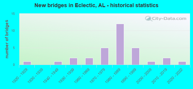
- New bridges - historical statistics
- 11920-1929
- 11940-1949
- 21950-1959
- 21960-1969
- 51970-1979
- 121980-1989
- 51990-1999
- 12000-2009
- 22010-2019
- 12020-2022
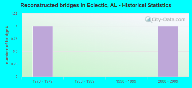
- Reconstructed bridges - Historical Statistics
- 11970-1979
- 01980-1989
- 01990-1999
- 12000-2009
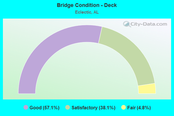
- Bridge Condition - Deck
- 57.1%Good
- 38.1%Satisfactory
- 4.8%Fair
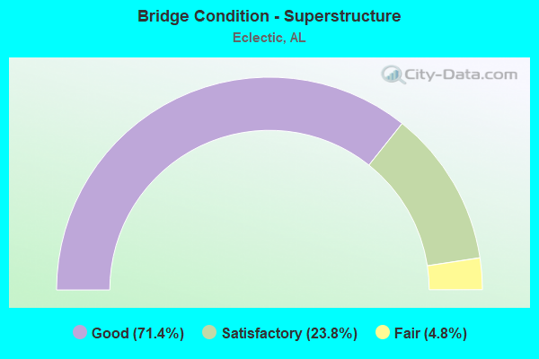
- Bridge Condition - Superstructure
- 71.4%Good
- 23.8%Satisfactory
- 4.8%Fair
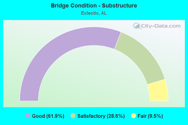
- Bridge Condition - Substructure
- 61.9%Good
- 28.6%Satisfactory
- 9.5%Fair
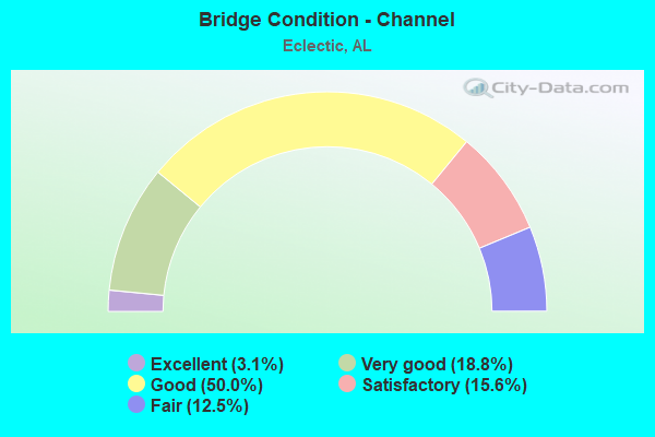
- Bridge Condition - Channel
- 3.1%Excellent
- 18.8%Very good
- 50.0%Good
- 15.6%Satisfactory
- 12.5%Fair
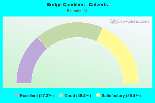
- Bridge Condition - Culverts
- 27.3%Excellent
- 36.4%Good
- 36.4%Satisfactory
Find on map >> Show street view
Structure Number: 7396, Location: SEC 35 T19N R20E (Lat: 32.586667, Lng: -86.033333), Route carried "on" structure: County highway 34, Year Built: 1966, Status: Open, Structure Length: 2.90m (9.51ft), Average Daily Traffic: 300 (year 1998), Truck Traffic: 15%, Average Future Daily Traffic: 310 (year 2031), Design Load: H 15, Features Intersected: TUMPKEHATCHEE CREEK, Facility Carried by Structure: Claud Fleahop Road
Minimum Vertical Clearance: 30+ m (98+ ft), Kilometerpoint: 0.010, Lanes on structure: 2, Owner: County Highway Agency, Approaching Roadway Width: 8.5m (27.9ft), Material/Design: Concrete, Design/Construction: Channel Beam, Number Of Spans In Main Unit: 5, Length of Maximum Span: 5.8m (19.0ft), Curb-To-Curb Width: 7.4m (24.3ft), Out-to-Out Width: 7.8m (25.6ft)
Condition: Deck: Good, Superstructure: Good, Substructure: Good, Channel: Good, Operating Rating: 45.9 metric tons, Method Used To Determine Operating Rating: Load Factor (LF), Inventory Rating: 27.5 metric tons, Method Used To Determine Inventory Rating: Load Factor (LF), Structural Evaluation: Equal to present minimum criteria, Deck Geometry: Somewhat better than minimum adequacy, Waterway Adequacy: Better than present minimum criteria, Approach Roadway Alignment: Somewhat better than minimum adequacy, Length Of Structure Improvement: 3.81m (12.50ft), Designated Inspection Frequency: Every 24 months, Inspection Date: April 2020, Bridge Improvement Cost: $653,000, Roadway Improvement Cost: $65,000, Total Project Cost: $718,000 ( Estimate for 2022), Deck Structure Type: Concrete Precast Panels, Wearing Surface/Protective System: Wearing Surface: Bituminous
Find on map >> Show street view
Structure Number: 8024, Location: SEC 5 T19N R21E (Lat: 32.658333, Lng: -85.980000), Route carried "on" structure: County highway 67, Year Built: 1967, Year Reconstructed: 2007, Status: Posted for load, Structure Length: 5.79m (19.00ft), Average Daily Traffic: 160 (year 1998), Truck Traffic: 6%, Average Future Daily Traffic: 180 (year 2030), Design Load: H 15, Features Intersected: CHANNAHATCHEE CREEK, Facility Carried by Structure: Double Bridge
Minimum Vertical Clearance: 30+ m (98+ ft), Kilometerpoint: 0.010, Lanes on structure: 2, Owner: County Highway Agency, Approaching Roadway Width: 8.5m (27.9ft), Material/Design: Concrete, Design/Construction: Channel Beam, Number Of Spans In Main Unit: 10, Length of Maximum Span: 5.8m (19.0ft), Curb-To-Curb Width: 7.4m (24.3ft), Out-to-Out Width: 7.8m (25.6ft)
Condition: Deck: Satisfactory, Superstructure: Fair, Substructure: Satisfactory, Channel: Good, Operating Rating: 34.5 metric tons, Method Used To Determine Operating Rating: Load Factor (LF), Inventory Rating: 20.7 metric tons, Method Used To Determine Inventory Rating: Load Factor (LF), Structural Evaluation: Somewhat better than minimum adequacy, Deck Geometry: Somewhat better than minimum adequacy, Waterway Adequacy: Equal to present minimum criteria, Approach Roadway Alignment: Equal to present minimum criteria, Bridge Posting: Required (Relationship of Operating Rating to Maximum Legal Load: 10.0 - 19.9% below), Length Of Structure Improvement: 6.83m (22.41ft), Designated Inspection Frequency: Every 24 months, Other Special Inspection Frequency: Every 12 months, Inspection Date: August 2021, Other Special Inspection Date: August 2021, Bridge Improvement Cost: $1,171,000, Roadway Improvement Cost: $117,000, Total Project Cost: $1,288,000 ( Estimate for 2022), Deck Structure Type: Concrete Precast Panels, Wearing Surface/Protective System: Wearing Surface: Bituminous
Find on map >> Show street view
Structure Number: 10936, Location: SEC 17 T17N R19E (Lat: 32.458303, Lng: -86.181986), Route carried "on" structure: County highway 8, Year Built: 1973, Status: Open, Structure Length: 3.47m (11.38ft), Average Daily Traffic: 8,500 (year 2004), Truck Traffic: 20%, Average Future Daily Traffic: 15,000 (year 2031), Design Load: H 15, Features Intersected: HARWELL MILL CREEK, Facility Carried by Structure: Redland Road
Minimum Vertical Clearance: 30+ m (98+ ft), Kilometerpoint: 0.010, Lanes on structure: 2, Owner: County Highway Agency, Approaching Roadway Width: 8.5m (27.9ft), Material/Design: Concrete, Design/Construction: Channel Beam, Number Of Spans In Main Unit: 6, Length of Maximum Span: 5.8m (19.0ft), Curb-To-Curb Width: 7.9m (25.9ft), Out-to-Out Width: 8.5m (27.9ft)
Condition: Deck: Satisfactory, Superstructure: Satisfactory, Substructure: Fair, Channel: Fair, Operating Rating: 45.9 metric tons, Method Used To Determine Operating Rating: Load Factor (LF), Inventory Rating: 27.5 metric tons, Method Used To Determine Inventory Rating: Load Factor (LF), Structural Evaluation: Somewhat better than minimum adequacy, Deck Geometry: High priority of replacement, Waterway Adequacy: Better than present minimum criteria, Approach Roadway Alignment: Better than present minimum criteria, Length Of Structure Improvement: 4.37m (14.34ft), Designated Inspection Frequency: Every 24 months, Inspection Date: August 2020, Bridge Improvement Cost: $809,000, Roadway Improvement Cost: $81,000, Total Project Cost: $890,000 ( Estimate for 2022), Deck Structure Type: Concrete Precast Panels, Wearing Surface/Protective System: Wearing Surface: Bituminous
Find on map >> Show street view
Structure Number: 11257, Location: SEC 1 T19N R20E (Lat: 32.654975, Lng: -86.022739), Route carried "on" structure: County highway 73, Year Built: 1974, Status: Open, Structure Length: 4.63m (15.19ft), Average Daily Traffic: 350 (year 1998), Truck Traffic: 4%, Average Future Daily Traffic: 370 (year 2031), Design Load: H 15, Features Intersected: CHANNAHATCHEE CREEK, Facility Carried by Structure: North Ann Street
Minimum Vertical Clearance: 30+ m (98+ ft), Kilometerpoint: 0.010, Lanes on structure: 2, Owner: County Highway Agency, Approaching Roadway Width: 8.5m (27.9ft), Material/Design: Concrete, Design/Construction: Channel Beam, Number Of Spans In Main Unit: 8, Length of Maximum Span: 5.8m (19.0ft), Curb-To-Curb Width: 7.9m (25.9ft), Out-to-Out Width: 8.5m (27.9ft)
Condition: Deck: Fair, Superstructure: Satisfactory, Substructure: Fair, Channel: Satisfactory, Operating Rating: 45.9 metric tons, Method Used To Determine Operating Rating: Load Factor (LF), Inventory Rating: 27.5 metric tons, Method Used To Determine Inventory Rating: Load Factor (LF), Structural Evaluation: Somewhat better than minimum adequacy, Deck Geometry: Somewhat better than minimum adequacy, Waterway Adequacy: Equal to present desirable criteria, Approach Roadway Alignment: Better than present minimum criteria, Length Of Structure Improvement: 5.63m (18.47ft), Designated Inspection Frequency: Every 24 months, Other Special Inspection Frequency: Every 12 months, Inspection Date: July 2020, Other Special Inspection Date: July 2021, Bridge Improvement Cost: $1,042,000, Roadway Improvement Cost: $104,000, Total Project Cost: $1,146,000 ( Estimate for 2022), Deck Structure Type: Concrete Precast Panels, Wearing Surface/Protective System: Wearing Surface: Bituminous
Find on map >> Show street view
Structure Number: 11474, Location: SEC 29 T20N R20E (Lat: 32.685000, Lng: -86.091667), Route carried "on" structure: County highway 80, Year Built: 1975, Status: Open, Structure Length: 1.16m (3.81ft), Average Daily Traffic: 450 (year 1998), Truck Traffic: 12%, Average Future Daily Traffic: 460 (year 2032), Design Load: HS 15, Features Intersected: CHANNAHATCHEE CREEK, Facility Carried by Structure: Mt. Hebron Road
Minimum Vertical Clearance: 30+ m (98+ ft), Kilometerpoint: 0.010, Lanes on structure: 2, Owner: County Highway Agency, Approaching Roadway Width: 7.9m (25.9ft), Material/Design: Concrete, Design/Construction: Channel Beam, Number Of Spans In Main Unit: 2, Length of Maximum Span: 5.8m (19.0ft), Curb-To-Curb Width: 7.9m (25.9ft), Out-to-Out Width: 8.5m (27.9ft)
Condition: Deck: Satisfactory, Superstructure: Satisfactory, Substructure: Satisfactory, Channel: Good, Operating Rating: 38.6 metric tons, Method Used To Determine Operating Rating: Load Factor (LF), Inventory Rating: 18.4 metric tons, Method Used To Determine Inventory Rating: Load Factor (LF), Structural Evaluation: Somewhat better than minimum adequacy, Deck Geometry: Somewhat better than minimum adequacy, Waterway Adequacy: Equal to present desirable criteria, Approach Roadway Alignment: Equal to present desirable criteria, Length Of Structure Improvement: 1.84m (6.04ft), Designated Inspection Frequency: Every 24 months, Inspection Date: June 2021, Bridge Improvement Cost: $340,000, Roadway Improvement Cost: $34,000, Total Project Cost: $374,000 ( Estimate for 2022), Deck Structure Type: Concrete Precast Panels, Wearing Surface/Protective System: Wearing Surface: Bituminous
Find on map >> Show street view
Structure Number: 11947, Location: SEC 35 T20N R20E (Lat: 32.671228, Lng: -86.040508), Route carried "on" structure: County highway , Year Built: 1978, Status: Open, Structure Length: 4.05m (13.29ft), Average Daily Traffic: 40 (year 1998), Average Future Daily Traffic: 45 (year 2030), Design Load: H 15, Features Intersected: CHANNAHATCHEE CREEK, Facility Carried by Structure: Avant Road
Minimum Vertical Clearance: 30+ m (98+ ft), Kilometerpoint: 0.010, Lanes on structure: 2, Owner: County Highway Agency, Approaching Roadway Width: 8.5m (27.9ft), Material/Design: Concrete, Design/Construction: Channel Beam, Number Of Spans In Main Unit: 7, Length of Maximum Span: 5.8m (19.0ft), Curb-To-Curb Width: 7.9m (25.9ft), Out-to-Out Width: 8.5m (27.9ft)
Condition: Deck: Good, Superstructure: Good, Substructure: Good, Channel: Very good, Operating Rating: 45.9 metric tons, Method Used To Determine Operating Rating: Load Factor (LF), Inventory Rating: 27.5 metric tons, Method Used To Determine Inventory Rating: Load Factor (LF), Structural Evaluation: Equal to present minimum criteria, Deck Geometry: Equal to present minimum criteria, Waterway Adequacy: Equal to present desirable criteria, Approach Roadway Alignment: Equal to present minimum criteria, Length Of Structure Improvement: 5.01m (16.44ft), Designated Inspection Frequency: Every 24 months, Inspection Date: August 2021, Bridge Improvement Cost: $928,000, Roadway Improvement Cost: $93,000, Total Project Cost: $1,021,000 ( Estimate for 2022), Deck Structure Type: Concrete Precast Panels
Find on map >> Show street view
Structure Number: 12213, Location: SEC 36 T20N R19E (Lat: 32.681667, Lng: -86.126667), Route carried "on" structure: County highway 80, Year Built: 1979, Status: Open, Structure Length: 3.47m (11.38ft), Average Daily Traffic: 300 (year 1998), Truck Traffic: 8%, Average Future Daily Traffic: 400 (year 2030), Design Load: H 15, Features Intersected: PATTERSON CREEK, Facility Carried by Structure: West Central Road
Minimum Vertical Clearance: 7.56m (24.80ft), Kilometerpoint: 0.010, Lanes on structure: 2, Owner: County Highway Agency, Approaching Roadway Width: 8.5m (27.9ft), Material/Design: Concrete, Design/Construction: Channel Beam, Number Of Spans In Main Unit: 6, Length of Maximum Span: 5.8m (19.0ft), Curb-To-Curb Width: 7.9m (25.9ft), Out-to-Out Width: 8.5m (27.9ft)
Condition: Deck: Satisfactory, Superstructure: Good, Substructure: Satisfactory, Channel: Very good, Operating Rating: 45.9 metric tons, Method Used To Determine Operating Rating: Load Factor (LF), Inventory Rating: 27.5 metric tons, Method Used To Determine Inventory Rating: Load Factor (LF), Structural Evaluation: Equal to present minimum criteria, Deck Geometry: Somewhat better than minimum adequacy, Waterway Adequacy: Equal to present desirable criteria, Approach Roadway Alignment: Better than present minimum criteria, Length Of Structure Improvement: 4.38m (14.37ft), Designated Inspection Frequency: Every 24 months, Inspection Date: May 2021, Bridge Improvement Cost: $810,000, Roadway Improvement Cost: $81,000, Total Project Cost: $891,000 ( Estimate for 2022), Deck Structure Type: Concrete Precast Panels, Wearing Surface/Protective System: Wearing Surface: Bituminous
Find on map >> Show street view
Structure Number: 12586, Location: SEC.22,T19N,R20E (Lat: 32.606511, Lng: -86.078094), Route carried "on" structure: County highway 42, Year Built: 1981, Status: Open, Structure Length: 1.74m (5.71ft), Average Daily Traffic: 200 (year 1998), Truck Traffic: 15%, Average Future Daily Traffic: 300 (year 2031), Design Load: H 15, Features Intersected: TOWNSEND CREEK, Facility Carried by Structure: Old Salem Road
Minimum Vertical Clearance: 30+ m (98+ ft), Kilometerpoint: 0.010, Lanes on structure: 2, Owner: County Highway Agency, Approaching Roadway Width: 8.5m (27.9ft), Material/Design: Concrete, Design/Construction: Channel Beam, Number Of Spans In Main Unit: 3, Length of Maximum Span: 5.8m (19.0ft), Curb-To-Curb Width: 7.9m (25.9ft), Out-to-Out Width: 8.5m (27.9ft)
Condition: Deck: Good, Superstructure: Good, Substructure: Good, Channel: Good, Operating Rating: 46.6 metric tons, Method Used To Determine Operating Rating: Load Factor (LF), Inventory Rating: 27.9 metric tons, Method Used To Determine Inventory Rating: Load Factor (LF), Structural Evaluation: Better than present minimum criteria, Deck Geometry: Somewhat better than minimum adequacy, Waterway Adequacy: Equal to present desirable criteria, Approach Roadway Alignment: Better than present minimum criteria, Length Of Structure Improvement: 2.44m (8.01ft), Designated Inspection Frequency: Every 24 months, Inspection Date: January 2022, Bridge Improvement Cost: $452,000, Roadway Improvement Cost: $45,000, Total Project Cost: $497,000 ( Estimate for 2022), Deck Structure Type: Concrete Precast Panels, Wearing Surface/Protective System: Wearing Surface: Bituminous
Find on map >> Show street view
Structure Number: 12858, Location: 0.2 MI.E.OF AL 63 (Lat: 32.578208, Lng: -86.066764), Route carried "on" structure: State highway 14, Year Built: 1929, Year Reconstructed: 1983, Status: Open, Structure Length: 0.67m (2.20ft), Average Daily Traffic: 4,060 (year 2013), Truck Traffic: 3%, Average Future Daily Traffic: 5,468 (year 2033), Design Load: HS 20, Features Intersected: BRANCH
Minimum Vertical Clearance: 30+ m (98+ ft), Kilometerpoint: 290.984, Lanes on structure: 2, Owner: State Highway Agency, Approaching Roadway Width: 12.2m (40.0ft), Material/Design: Concrete continuous, Design/Construction: Culvert, Number Of Spans In Main Unit: 2, Length of Maximum Span: 3.0m (9.8ft)
Condition: Channel: Good, Culverts: Satisfactory, Operating Rating: 63.1 metric tons, Method Used To Determine Operating Rating: Load Factor (LF), Inventory Rating: 37.9 metric tons, Method Used To Determine Inventory Rating: Load Factor (LF), Structural Evaluation: Equal to present minimum criteria, Waterway Adequacy: Better than present minimum criteria, Approach Roadway Alignment: Better than present minimum criteria, Length Of Structure Improvement: 1.30m (4.27ft), Designated Inspection Frequency: Every 24 months, Inspection Date: March 2020, Bridge Improvement Cost: $203,000, Roadway Improvement Cost: $20,000, Total Project Cost: $223,000 ( Estimate for 2022)
Find on map >> Show street view
Structure Number: 12983, Location: 1.0 MI.W.OF AL 63 (Lat: 32.580000, Lng: -86.088333), Route carried "on" structure: State highway 14, Year Built: 1983, Status: Open, Structure Length: 8.75m (28.71ft), Average Daily Traffic: 6,020 (year 2013), Truck Traffic: 7%, Average Future Daily Traffic: 8,108 (year 2033), Design Load: HS 20, Features Intersected: CHUBBEHATCHEE CREEK
Minimum Vertical Clearance: 30+ m (98+ ft), Kilometerpoint: 288.879, Lanes on structure: 2, Owner: State Highway Agency, Approaching Roadway Width: 12.2m (40.0ft), Material/Design: Prestressed concrete, Design/Construction: Stringer/Multi-beam, Number Of Spans In Main Unit: 7, Length of Maximum Span: 12.5m (41.0ft), Curb-To-Curb Width: 12.2m (40.0ft), Out-to-Out Width: 13.0m (42.7ft)
Condition: Deck: Satisfactory, Superstructure: Satisfactory, Substructure: Satisfactory, Channel: Fair, Operating Rating: 49.0 metric tons, Method Used To Determine Operating Rating: Load Factor (LF), Inventory Rating: 29.3 metric tons, Method Used To Determine Inventory Rating: Load Factor (LF), Structural Evaluation: Equal to present minimum criteria, Deck Geometry: Somewhat better than minimum adequacy, Waterway Adequacy: Better than present minimum criteria, Approach Roadway Alignment: Better than present minimum criteria, Length Of Structure Improvement: 9.73m (31.92ft), Designated Inspection Frequency: Every 24 months, Inspection Date: March 2020, Bridge Improvement Cost: $2,803,000, Roadway Improvement Cost: $280,000, Total Project Cost: $3,083,000 ( Estimate for 2022), Deck Structure Type: Concrete Cast-file-Place
Find on map >> Show street view
Structure Number: 12984, Location: 0.2 MI.W.OF AL 63 (Lat: 32.580000, Lng: -86.073300), Route carried "on" structure: State highway 14, Year Built: 1983, Status: Open, Structure Length: 3.75m (12.30ft), Average Daily Traffic: 5,250 (year 2013), Truck Traffic: 5%, Average Future Daily Traffic: 7,071 (year 2033), Design Load: HS 20, Features Intersected: HANEY CREEK
Minimum Vertical Clearance: 30+ m (98+ ft), Kilometerpoint: 290.334, Lanes on structure: 2, Owner: State Highway Agency, Approaching Roadway Width: 12.2m (40.0ft), Material/Design: Prestressed concrete, Design/Construction: Stringer/Multi-beam, Number Of Spans In Main Unit: 3, Length of Maximum Span: 12.5m (41.0ft), Curb-To-Curb Width: 12.2m (40.0ft), Out-to-Out Width: 13.0m (42.7ft)
Condition: Deck: Good, Superstructure: Good, Substructure: Good, Channel: Satisfactory, Operating Rating: 49.0 metric tons, Method Used To Determine Operating Rating: Load Factor (LF), Inventory Rating: 29.3 metric tons, Method Used To Determine Inventory Rating: Load Factor (LF), Structural Evaluation: Better than present minimum criteria, Deck Geometry: Somewhat better than minimum adequacy, Waterway Adequacy: Superior to present desirable criteria, Approach Roadway Alignment: Better than present minimum criteria, Length Of Structure Improvement: 4.68m (15.35ft), Designated Inspection Frequency: Every 24 months, Inspection Date: March 2020, Bridge Improvement Cost: $1,347,000, Roadway Improvement Cost: $135,000, Total Project Cost: $1,482,000 ( Estimate for 2022), Deck Structure Type: Concrete Cast-file-Place
Find on map >> Show street view
Structure Number: 12985, Location: 2.2 MI.E.OF AL 63 (Lat: 32.573333, Lng: -86.031667), Route carried "on" structure: State highway 14, Year Built: 1983, Status: Open, Structure Length: 3.75m (12.30ft), Average Daily Traffic: 3,380 (year 2013), Truck Traffic: 4%, Average Future Daily Traffic: 4,552 (year 2033), Design Load: HS 20, Features Intersected: TUMPKEEHATCHEE CREEK
Minimum Vertical Clearance: 30+ m (98+ ft), Kilometerpoint: 294.196, Lanes on structure: 2, Owner: State Highway Agency, Approaching Roadway Width: 12.2m (40.0ft), Skew: 3 degrees, Material/Design: Prestressed concrete, Design/Construction: Stringer/Multi-beam, Number Of Spans In Main Unit: 3, Length of Maximum Span: 12.5m (41.0ft), Curb-To-Curb Width: 12.2m (40.0ft), Out-to-Out Width: 13.0m (42.7ft)
Condition: Deck: Satisfactory, Superstructure: Good, Substructure: Good, Channel: Excellent, Operating Rating: 49.0 metric tons, Method Used To Determine Operating Rating: Load Factor (LF), Inventory Rating: 29.3 metric tons, Method Used To Determine Inventory Rating: Load Factor (LF), Structural Evaluation: Better than present minimum criteria, Deck Geometry: Equal to present minimum criteria, Waterway Adequacy: Superior to present desirable criteria, Approach Roadway Alignment: Better than present minimum criteria, Length Of Structure Improvement: 4.68m (15.35ft), Designated Inspection Frequency: Every 24 months, Inspection Date: March 2020, Bridge Improvement Cost: $1,347,000, Roadway Improvement Cost: $135,000, Total Project Cost: $1,482,000 ( Estimate for 2022), Deck Structure Type: Concrete Cast-file-Place
Find on map >> Show street view
Structure Number: 12986, Location: 4.3 MI.E.OF AL 63 (Lat: 32.580636, Lng: -85.992450), Route carried "on" structure: State highway 14, Year Built: 1983, Status: Open, Structure Length: 0.88m (2.89ft), Average Daily Traffic: 3,620 (year 2013), Truck Traffic: 4%, Average Future Daily Traffic: 4,876 (year 2033), Design Load: HS 20, Features Intersected: WALLAHATCHEE CREEK
Minimum Vertical Clearance: 30+ m (98+ ft), Kilometerpoint: 297.518, Lanes on structure: 2, Owner: State Highway Agency, Approaching Roadway Width: 12.2m (40.0ft), Skew: 3 degrees, Material/Design: Concrete continuous, Design/Construction: Culvert, Number Of Spans In Main Unit: 2, Length of Maximum Span: 3.7m (12.1ft)
Condition: Channel: Fair, Culverts: Satisfactory, Operating Rating: 75.1 metric tons, Method Used To Determine Operating Rating: Load Factor (LF), Inventory Rating: 45.1 metric tons, Method Used To Determine Inventory Rating: Load Factor (LF), Structural Evaluation: Equal to present minimum criteria, Waterway Adequacy: Better than present minimum criteria, Approach Roadway Alignment: Better than present minimum criteria, Length Of Structure Improvement: 1.55m (5.09ft), Designated Inspection Frequency: Every 24 months, Inspection Date: March 2020, Bridge Improvement Cost: $688,000, Roadway Improvement Cost: $69,000, Total Project Cost: $757,000 ( Estimate for 2022)
Find on map >> Show street view
Structure Number: 12987, Location: 4.6 MI.E.OF AL 63 (Lat: 32.580233, Lng: -86.000097), Route carried "on" structure: State highway 14, Year Built: 1983, Status: Open, Structure Length: 5.00m (16.40ft), Average Daily Traffic: 3,620 (year 2013), Truck Traffic: 4%, Average Future Daily Traffic: 4,876 (year 2033), Design Load: HS 20, Features Intersected: WALLAHATCHEE CREEK#1
Minimum Vertical Clearance: 30+ m (98+ ft), Kilometerpoint: 298.047, Lanes on structure: 2, Owner: State Highway Agency, Approaching Roadway Width: 12.2m (40.0ft), Material/Design: Prestressed concrete, Design/Construction: Stringer/Multi-beam, Number Of Spans In Main Unit: 4, Length of Maximum Span: 12.5m (41.0ft), Curb-To-Curb Width: 12.2m (40.0ft), Out-to-Out Width: 13.0m (42.7ft)
Condition: Deck: Good, Superstructure: Good, Substructure: Satisfactory, Channel: Fair, Operating Rating: 49.0 metric tons, Method Used To Determine Operating Rating: Load Factor (LF), Inventory Rating: 29.3 metric tons, Method Used To Determine Inventory Rating: Load Factor (LF), Structural Evaluation: Equal to present minimum criteria, Deck Geometry: Equal to present minimum criteria, Waterway Adequacy: Better than present minimum criteria, Approach Roadway Alignment: Better than present minimum criteria, Length Of Structure Improvement: 6.02m (19.75ft), Designated Inspection Frequency: Every 24 months, Inspection Date: March 2020, Bridge Improvement Cost: $1,732,000, Roadway Improvement Cost: $173,000, Total Project Cost: $1,905,000 ( Estimate for 2022), Deck Structure Type: Concrete Cast-file-Place
Find on map >> Show street view
Structure Number: 13391, Location: SEC 25 T19N R20E (Lat: 32.608333, Lng: -86.010000), Route carried "on" structure: County highway 180, Year Built: 1984, Status: Open, Structure Length: 1.74m (5.71ft), Average Daily Traffic: 330 (year 1998), Truck Traffic: 12%, Average Future Daily Traffic: 380 (year 2031), Design Load: H 15, Features Intersected: WALLAHATCHEE CREEK, Facility Carried by Structure: Claud Fleahop Road
Minimum Vertical Clearance: 30+ m (98+ ft), Kilometerpoint: 0.010, Lanes on structure: 2, Owner: County Highway Agency, Approaching Roadway Width: 8.5m (27.9ft), Material/Design: Concrete, Design/Construction: Channel Beam, Number Of Spans In Main Unit: 3, Length of Maximum Span: 5.8m (19.0ft), Curb-To-Curb Width: 7.9m (25.9ft), Out-to-Out Width: 8.5m (27.9ft)
Condition: Deck: Good, Superstructure: Good, Substructure: Good, Channel: Good, Operating Rating: 45.9 metric tons, Method Used To Determine Operating Rating: Load Factor (LF), Inventory Rating: 27.5 metric tons, Method Used To Determine Inventory Rating: Load Factor (LF), Structural Evaluation: Equal to present minimum criteria, Deck Geometry: Somewhat better than minimum adequacy, Waterway Adequacy: Equal to present desirable criteria, Approach Roadway Alignment: Equal to present minimum criteria, Length Of Structure Improvement: 2.44m (8.01ft), Designated Inspection Frequency: Every 24 months, Inspection Date: April 2020, Bridge Improvement Cost: $452,000, Roadway Improvement Cost: $45,000, Total Project Cost: $497,000 ( Estimate for 2022), Deck Structure Type: Concrete Precast Panels, Wearing Surface/Protective System: Wearing Surface: Bituminous
Find on map >> Show street view
Structure Number: 13395, Location: SEC 30 T19N R20E (Lat: 32.600000, Lng: -86.093333), Route carried "on" structure: County highway 192, Year Built: 1984, Status: Open, Structure Length: 2.99m (9.81ft), Average Daily Traffic: 300 (year 1998), Truck Traffic: 12%, Average Future Daily Traffic: 350 (year 2031), Design Load: H 15, Features Intersected: CHUBBEHATCHEE CREEK, Facility Carried by Structure: Old Salem Road
Minimum Vertical Clearance: 30+ m (98+ ft), Kilometerpoint: 0.010, Lanes on structure: 2, Owner: County Highway Agency, Approaching Roadway Width: 8.5m (27.9ft), Material/Design: Steel, Design/Construction: Stringer/Multi-beam, Number Of Spans In Main Unit: 2, Length of Maximum Span: 14.9m (48.9ft), Curb-To-Curb Width: 7.9m (25.9ft), Out-to-Out Width: 8.5m (27.9ft)
Condition: Deck: Good, Superstructure: Good, Substructure: Good, Channel: Very good, Operating Rating: 44.0 metric tons, Method Used To Determine Operating Rating: Load Factor (LF), Inventory Rating: 26.4 metric tons, Method Used To Determine Inventory Rating: Load Factor (LF), Structural Evaluation: Equal to present minimum criteria, Deck Geometry: Somewhat better than minimum adequacy, Waterway Adequacy: Equal to present desirable criteria, Approach Roadway Alignment: Better than present minimum criteria, Length Of Structure Improvement: 3.88m (12.73ft), Designated Inspection Frequency: Every 24 months, Inspection Date: January 2022, Bridge Improvement Cost: $719,000, Roadway Improvement Cost: $72,000, Total Project Cost: $791,000 ( Estimate for 2022), Deck Structure Type: Concrete Cast-file-Place
Find on map >> Show street view
Structure Number: 13972, Location: 3.0 MI.N.OF ECLECTIC (Lat: 32.669550, Lng: -86.037367), Route carried "on" structure: State highway 63, Year Built: 1986, Status: Open, Structure Length: 5.00m (16.40ft), Average Daily Traffic: 3,620 (year 2013), Truck Traffic: 6%, Average Future Daily Traffic: 5,022 (year 2033), Design Load: HS 20, Features Intersected: CHANNAHATCHEE CREEK
Minimum Vertical Clearance: 30+ m (98+ ft), Kilometerpoint: 12.311, Lanes on structure: 2, Owner: State Highway Agency, Approaching Roadway Width: 12.2m (40.0ft), Material/Design: Prestressed concrete continuous, Design/Construction: Stringer/Multi-beam, Number Of Spans In Main Unit: 4, Length of Maximum Span: 12.5m (41.0ft), Curb-To-Curb Width: 12.2m (40.0ft), Out-to-Out Width: 13.0m (42.7ft)
Condition: Deck: Satisfactory, Superstructure: Good, Substructure: Satisfactory, Channel: Satisfactory, Operating Rating: 49.0 metric tons, Method Used To Determine Operating Rating: Load Factor (LF), Inventory Rating: 29.3 metric tons, Method Used To Determine Inventory Rating: Load Factor (LF), Structural Evaluation: Equal to present minimum criteria, Deck Geometry: Equal to present minimum criteria, Waterway Adequacy: Superior to present desirable criteria, Approach Roadway Alignment: Better than present minimum criteria, Length Of Structure Improvement: 6.02m (19.75ft), Designated Inspection Frequency: Every 24 months, Inspection Date: April 2020, Bridge Improvement Cost: $1,732,000, Roadway Improvement Cost: $173,000, Total Project Cost: $1,905,000 ( Estimate for 2022), Deck Structure Type: Concrete Cast-file-Place
Find on map >> Show street view
Structure Number: 14008, Location: SEC 9 T19N R21E (Lat: 32.641667, Lng: -85.958333), Route carried "on" structure: County highway 173, Year Built: 1986, Status: Open, Structure Length: 1.74m (5.71ft), Average Daily Traffic: 235 (year 1998), Truck Traffic: 4%, Average Future Daily Traffic: 250 (year 2030), Design Load: H 15, Features Intersected: CHANNAHATCHEE CREEKSPUR, Facility Carried by Structure: Atkins Road
Minimum Vertical Clearance: 30+ m (98+ ft), Kilometerpoint: 0.010, Lanes on structure: 2, Owner: County Highway Agency, Approaching Roadway Width: 8.5m (27.9ft), Material/Design: Concrete, Design/Construction: Channel Beam, Number Of Spans In Main Unit: 3, Length of Maximum Span: 5.8m (19.0ft), Curb-To-Curb Width: 7.9m (25.9ft), Out-to-Out Width: 8.5m (27.9ft)
Condition: Deck: Good, Superstructure: Good, Substructure: Good, Channel: Good, Operating Rating: 45.9 metric tons, Method Used To Determine Operating Rating: Load Factor (LF), Inventory Rating: 27.5 metric tons, Method Used To Determine Inventory Rating: Load Factor (LF), Structural Evaluation: Equal to present minimum criteria, Deck Geometry: Somewhat better than minimum adequacy, Waterway Adequacy: Equal to present desirable criteria, Approach Roadway Alignment: Equal to present minimum criteria, Length Of Structure Improvement: 2.44m (8.01ft), Designated Inspection Frequency: Every 24 months, Inspection Date: July 2021, Bridge Improvement Cost: $452,000, Roadway Improvement Cost: $45,000, Total Project Cost: $497,000 ( Estimate for 2022), Deck Structure Type: Concrete Precast Panels, Wearing Surface/Protective System: Wearing Surface: Bituminous
Find on map >> Show street view
Structure Number: 14969, Location: SEC 3 T19N R20E (Lat: 32.663333, Lng: -86.125000), Route carried "on" structure: County highway 415, Year Built: 1989, Status: Open, Structure Length: 1.74m (5.71ft), Average Daily Traffic: 60 (year 1998), Average Future Daily Traffic: 70 (year 2030), Design Load: HS 15, Features Intersected: CHANNAHATCHEE CREEK, Facility Carried by Structure: Union Road
Minimum Vertical Clearance: 30+ m (98+ ft), Kilometerpoint: 0.010, Lanes on structure: 2, Owner: County Highway Agency, Approaching Roadway Width: 8.5m (27.9ft), Material/Design: Concrete, Design/Construction: Channel Beam, Number Of Spans In Main Unit: 3, Length of Maximum Span: 5.8m (19.0ft), Curb-To-Curb Width: 7.2m (23.6ft), Out-to-Out Width: 7.7m (25.3ft)
Condition: Deck: Satisfactory, Superstructure: Satisfactory, Substructure: Good, Channel: Good, Operating Rating: 37.2 metric tons, Method Used To Determine Operating Rating: Load Factor (LF), Inventory Rating: 22.3 metric tons, Method Used To Determine Inventory Rating: Load Factor (LF), Structural Evaluation: Equal to present minimum criteria, Deck Geometry: Somewhat better than minimum adequacy, Waterway Adequacy: Equal to present desirable criteria, Approach Roadway Alignment: Better than present minimum criteria, Length Of Structure Improvement: 2.44m (8.01ft), Designated Inspection Frequency: Every 24 months, Inspection Date: August 2021, Bridge Improvement Cost: $418,000, Roadway Improvement Cost: $42,000, Total Project Cost: $460,000 ( Estimate for 2022), Deck Structure Type: Concrete Precast Panels, Wearing Surface/Protective System: Wearing Surface: Bituminous
Find on map >> Show street view
Structure Number: 15072, Location: SEC 17 T19N R20E (Lat: 32.635000, Lng: -86.086667), Route carried "on" structure: County highway , Year Built: 1990, Status: Open, Structure Length: 1.16m (3.81ft), Average Daily Traffic: 20 (year 1998), Average Future Daily Traffic: 25 (year 2031), Design Load: HS 20, Features Intersected: SAND CREEK, Facility Carried by Structure: Whipporwill Road
Minimum Vertical Clearance: 30+ m (98+ ft), Kilometerpoint: 0.010, Lanes on structure: 2, Owner: County Highway Agency, Approaching Roadway Width: 8.5m (27.9ft), Material/Design: Concrete, Design/Construction: Channel Beam, Number Of Spans In Main Unit: 3, Length of Maximum Span: 5.8m (19.0ft), Curb-To-Curb Width: 8.5m (27.9ft), Out-to-Out Width: 9.3m (30.5ft)
Condition: Deck: Good, Superstructure: Good, Substructure: Good, Channel: Good, Operating Rating: 47.4 metric tons, Method Used To Determine Operating Rating: Load Factor (LF), Inventory Rating: 28.4 metric tons, Method Used To Determine Inventory Rating: Load Factor (LF), Structural Evaluation: Better than present minimum criteria, Deck Geometry: Better than present minimum criteria, Waterway Adequacy: Equal to present desirable criteria, Approach Roadway Alignment: Equal to present desirable criteria, Length Of Structure Improvement: 1.84m (6.04ft), Designated Inspection Frequency: Every 24 months, Inspection Date: January 2022, Bridge Improvement Cost: $378,000, Roadway Improvement Cost: $38,000, Total Project Cost: $416,000 ( Estimate for 2022), Deck Structure Type: Concrete Precast Panels
Find on map >> Show street view
Structure Number: 15073, Location: SEC 17 T19N R20E (Lat: 32.633333, Lng: -86.086667), Route carried "on" structure: County highway , Year Built: 1990, Status: Open, Structure Length: 1.74m (5.71ft), Average Daily Traffic: 20 (year 1998), Average Future Daily Traffic: 25 (year 2031), Design Load: HS 20, Features Intersected: SAND CREEK, Facility Carried by Structure: Whipporwill Road
Minimum Vertical Clearance: 30+ m (98+ ft), Kilometerpoint: 0.010, Lanes on structure: 2, Owner: County Highway Agency, Approaching Roadway Width: 8.5m (27.9ft), Material/Design: Concrete, Design/Construction: Channel Beam, Number Of Spans In Main Unit: 3, Length of Maximum Span: 5.8m (19.0ft), Curb-To-Curb Width: 8.5m (27.9ft), Out-to-Out Width: 9.3m (30.5ft)
Condition: Deck: Good, Superstructure: Good, Substructure: Good, Channel: Good, Operating Rating: 47.4 metric tons, Method Used To Determine Operating Rating: Load Factor (LF), Inventory Rating: 28.4 metric tons, Method Used To Determine Inventory Rating: Load Factor (LF), Structural Evaluation: Better than present minimum criteria, Deck Geometry: Better than present minimum criteria, Waterway Adequacy: Equal to present desirable criteria, Approach Roadway Alignment: Equal to present desirable criteria, Length Of Structure Improvement: 2.44m (8.01ft), Designated Inspection Frequency: Every 24 months, Inspection Date: January 2022, Bridge Improvement Cost: $502,000, Roadway Improvement Cost: $50,000, Total Project Cost: $552,000 ( Estimate for 2022), Deck Structure Type: Concrete Precast Panels
Find on map >> Show street view
Structure Number: 16878, Location: 6.9MI E OF AL 14 (Lat: 32.619567, Lng: -86.102575), Route carried "on" structure: State highway 170, Year Built: 1998, Status: Open, Structure Length: 0.65m (2.13ft), Average Daily Traffic: 3,640 (year 2013), Truck Traffic: 7%, Average Future Daily Traffic: 4,441 (year 2033), Design Load: HS 20, Features Intersected: CHUBBEHATCHEE CREEK
Minimum Vertical Clearance: 30+ m (98+ ft), Kilometerpoint: 12.497, Lanes on structure: 2, Base Highway Network: Yes, Owner: State Highway Agency, Approaching Roadway Width: 7.1m (23.3ft), Material/Design: Concrete continuous, Design/Construction: Culvert, Number Of Spans In Main Unit: 2, Length of Maximum Span: 3.1m (10.2ft)
Condition: Channel: Satisfactory, Culverts: Satisfactory, Operating Rating: 88.9 metric tons, Method Used To Determine Operating Rating: Load Factor (LF), Inventory Rating: 88.9 metric tons, Method Used To Determine Inventory Rating: Load Factor (LF), Structural Evaluation: Equal to present minimum criteria, Waterway Adequacy: Superior to present desirable criteria, Approach Roadway Alignment: Better than present minimum criteria, Length Of Structure Improvement: 1.27m (4.17ft), Designated Inspection Frequency: Every 24 months, Inspection Date: January 2022, Bridge Improvement Cost: $756,000, Roadway Improvement Cost: $76,000, Total Project Cost: $832,000 ( Estimate for 2022)
Find on map >> Show street view
Structure Number: 16879, Location: 7.9MI E OF AL 14 (Lat: 32.628731, Lng: -86.089314), Route carried "on" structure: State highway 170, Year Built: 1998, Status: Open, Structure Length: 1.50m (4.92ft), Average Daily Traffic: 3,640 (year 2013), Truck Traffic: 7%, Average Future Daily Traffic: 4,441 (year 2033), Design Load: HS 20, Features Intersected: SAND CREEK
Minimum Vertical Clearance: 30+ m (98+ ft), Kilometerpoint: 14.143, Lanes on structure: 2, Owner: State Highway Agency, Approaching Roadway Width: 7.4m (24.3ft), Material/Design: Concrete continuous, Design/Construction: Culvert, Number Of Spans In Main Unit: 3, Length of Maximum Span: 4.9m (16.1ft)
Condition: Channel: Satisfactory, Culverts: Satisfactory, Operating Rating: 88.9 metric tons, Method Used To Determine Operating Rating: Load Factor (LF), Inventory Rating: 88.9 metric tons, Method Used To Determine Inventory Rating: Load Factor (LF), Structural Evaluation: Equal to present minimum criteria, Waterway Adequacy: Superior to present desirable criteria, Approach Roadway Alignment: Better than present minimum criteria, Length Of Structure Improvement: 2.18m (7.15ft), Designated Inspection Frequency: Every 24 months, Inspection Date: January 2022, Bridge Improvement Cost: $1,610,000, Roadway Improvement Cost: $161,000, Total Project Cost: $1,771,000 ( Estimate for 2022)
Find on map >> Show street view
Structure Number: 17364, Location: 1.0 MI S OF CO RD 55 (Lat: 32.716667, Lng: -86.066667), Route carried "on" structure: County highway , Year Built: 1998, Status: Open, Structure Length: 1.74m (5.71ft), Average Daily Traffic: 30 (year 1998), Average Future Daily Traffic: 60 (year 2030), Design Load: HS 15, Features Intersected: STEARNS CREEK, Facility Carried by Structure: Lindsey Road
Minimum Vertical Clearance: 30+ m (98+ ft), Kilometerpoint: 0.000, Lanes on structure: 2, Owner: County Highway Agency, Approaching Roadway Width: 6.1m (20.0ft), Material/Design: Concrete, Design/Construction: Channel Beam, Number Of Spans In Main Unit: 3, Length of Maximum Span: 5.8m (19.0ft), Curb-To-Curb Width: 7.3m (24.0ft), Out-to-Out Width: 7.7m (25.3ft)
Condition: Deck: Good, Superstructure: Good, Substructure: Good, Channel: Good, Operating Rating: 47.3 metric tons, Method Used To Determine Operating Rating: Load Factor (LF), Inventory Rating: 28.3 metric tons, Method Used To Determine Inventory Rating: Load Factor (LF), Structural Evaluation: Better than present minimum criteria, Deck Geometry: Equal to present minimum criteria, Waterway Adequacy: Equal to present desirable criteria, Approach Roadway Alignment: Better than present minimum criteria, Length Of Structure Improvement: 2.44m (8.01ft), Designated Inspection Frequency: Every 24 months, Inspection Date: May 2021, Bridge Improvement Cost: $419,000, Roadway Improvement Cost: $42,000, Total Project Cost: $461,000 ( Estimate for 2022), Deck Structure Type: Concrete Precast Panels
Find on map >> Show street view
Structure Number: 20132, Location: 4 MI NE OF AL 9 (Lat: 32.739722, Lng: -86.063333), Route carried "on" structure: County highway 55, Year Built: 2008, Status: Open, Structure Length: 1.04m (3.41ft), Average Daily Traffic: 100 (year 2007), Average Future Daily Traffic: 300 (year 2032), Design Load: HS 20, Features Intersected: UNNAMED CREEK
Minimum Vertical Clearance: 30+ m (98+ ft), Kilometerpoint: 0.000, Lanes on structure: 2, Owner: County Highway Agency, Approaching Roadway Width: 8.5m (27.9ft), Material/Design: Concrete, Design/Construction: Channel Beam, Number Of Spans In Main Unit: 1, Length of Maximum Span: 10.4m (34.1ft), Curb-To-Curb Width: 8.5m (27.9ft), Out-to-Out Width: 9.3m (30.5ft)
Condition: Deck: Good, Superstructure: Good, Substructure: Good, Channel: Good, Operating Rating: 74.1 metric tons, Method Used To Determine Operating Rating: Load Factor (LF), Inventory Rating: 44.5 metric tons, Method Used To Determine Inventory Rating: Load Factor (LF), Structural Evaluation: Better than present minimum criteria, Deck Geometry: Better than present minimum criteria, Waterway Adequacy: Equal to present desirable criteria, Approach Roadway Alignment: Better than present minimum criteria, Length Of Structure Improvement: 1.71m (5.61ft), Designated Inspection Frequency: Every 24 months, Inspection Date: January 2021, Bridge Improvement Cost: $351,000, Roadway Improvement Cost: $35,000, Total Project Cost: $386,000 ( Estimate for 2022), Deck Structure Type: Concrete Precast Panels
Find on map >> Show street view
Structure Number: 20621, Location: ????????????????????????? (Lat: 32.671853, Lng: -85.960022), Route carried "on" structure: County highway 407, Year Built: 1954, Status: Open, Structure Length: 3.47m (11.38ft), Average Daily Traffic: 671 (year 2011), Average Future Daily Traffic: 1,000 (year 2030), Design Load: H 15, Features Intersected: GOLD BRANCH, Facility Carried by Structure: East Cotton Road
Minimum Vertical Clearance: 7.56m (24.80ft), Kilometerpoint: 0.000, Lanes on structure: 2, Owner: County Highway Agency, Approaching Roadway Width: 8.5m (27.9ft), Material/Design: Concrete, Design/Construction: Culvert, Number Of Spans In Main Unit: 3, Length of Maximum Span: 3.7m (12.1ft), Curb-To-Curb Width: 9.7m (31.8ft), Out-to-Out Width: 9.8m (32.2ft)
Condition: Channel: Good, Culverts: Good, Operating Rating: 40.0 metric tons, Method Used To Determine Operating Rating: Load Factor (LF), Inventory Rating: 24.0 metric tons, Method Used To Determine Inventory Rating: Load Factor (LF), Structural Evaluation: Equal to present minimum criteria, Deck Geometry: Equal to present minimum criteria, Waterway Adequacy: Equal to present desirable criteria, Approach Roadway Alignment: Equal to present minimum criteria, Length Of Structure Improvement: 4.38m (14.37ft), Designated Inspection Frequency: Every 24 months, Inspection Date: March 2020, Bridge Improvement Cost: $935,000, Roadway Improvement Cost: $94,000, Total Project Cost: $1,029,000 ( Estimate for 2022), Wearing Surface/Protective System: Wearing Surface: Bituminous
Find on map >> Show street view
Structure Number: 20915, Location: SEC9 T20 R19 (Lat: 32.728569, Lng: -86.180886), Route carried "on" structure: County highway 465, Year Built: 1988, Status: Open, Structure Length: 3.13m (10.27ft), Average Daily Traffic: 100 (year 2014), Average Future Daily Traffic: 125 (year 2031), Design Load: HS 20, Features Intersected: LITTLE WEOKA CREEK
Minimum Vertical Clearance: 30+ m (98+ ft), Kilometerpoint: 0.000, Lanes on structure: 2, Owner: County Highway Agency, Approaching Roadway Width: 6.1m (20.0ft), Material/Design: Concrete, Design/Construction: Culvert, Number Of Spans In Main Unit: 3, Length of Maximum Span: 3.7m (12.1ft)
Condition: Channel: Good, Culverts: Good, Operating Rating: 65.3 metric tons, Method Used To Determine Operating Rating: Load Factor (LF), Inventory Rating: 39.2 metric tons, Method Used To Determine Inventory Rating: Load Factor (LF), Structural Evaluation: Better than present minimum criteria, Waterway Adequacy: Equal to present desirable criteria, Approach Roadway Alignment: Equal to present minimum criteria, Length Of Structure Improvement: 3.98m (13.06ft), Designated Inspection Frequency: Every 24 months, Inspection Date: March 2020, Bridge Improvement Cost: $874,000, Roadway Improvement Cost: $87,000, Total Project Cost: $961,000 ( Estimate for 2022), Wearing Surface/Protective System: Wearing Surface: Bituminous
Find on map >> Show street view
Structure Number: 21306, Location: Sec9 T18N R17E (Lat: 32.556667, Lng: -86.370000), Route carried "on" structure: County highway 3, Year Built: 2017, Status: Open, Structure Length: 1.77m (5.81ft), Average Daily Traffic: 2,941 (year 2017), Truck Traffic: 4%, Average Future Daily Traffic: 4,370 (year 2037), Design Load: HS 20, Features Intersected: Middle Creek Spur, Facility Carried by Structure: Ingram Road
Minimum Vertical Clearance: 30+ m (98+ ft), Kilometerpoint: 0.010, Lanes on structure: 2, Owner: County Highway Agency, Approaching Roadway Width: 9.1m (29.9ft), Material/Design: Concrete, Design/Construction: Culvert, Number Of Spans In Main Unit: 3, Length of Maximum Span: 3.7m (12.1ft)
Condition: Channel: Very good, Culverts: Excellent, Operating Rating: 44.6 metric tons, Method Used To Determine Operating Rating: Load Factor (LF), Inventory Rating: 26.8 metric tons, Method Used To Determine Inventory Rating: Load Factor (LF), Structural Evaluation: Equal to present minimum criteria, Waterway Adequacy: Equal to present desirable criteria, Approach Roadway Alignment: Equal to present minimum criteria, Length Of Structure Improvement: 2.47m (8.10ft), Designated Inspection Frequency: Every 24 months, Inspection Date: November 2021, Bridge Improvement Cost: $828,000, Roadway Improvement Cost: $83,000, Total Project Cost: $911,000 ( Estimate for 2022), Deck Structure Type: Concrete Cast-file-Place
Find on map >> Show street view
Structure Number: 21307, Location: Sec9 T18N R17E (Lat: 32.556667, Lng: -86.370000), Route carried "on" structure: County highway 3, Year Built: 2017, Status: Open, Structure Length: 1.77m (5.81ft), Average Daily Traffic: 2,941 (year 2017), Truck Traffic: 4%, Average Future Daily Traffic: 4,370 (year 2037), Design Load: HS 20, Features Intersected: Middle Creek, Facility Carried by Structure: Ingram Road
Minimum Vertical Clearance: 30+ m (98+ ft), Kilometerpoint: 0.010, Lanes on structure: 2, Owner: County Highway Agency, Approaching Roadway Width: 9.1m (29.9ft), Material/Design: Concrete, Design/Construction: Culvert, Number Of Spans In Main Unit: 4, Length of Maximum Span: 4.3m (14.1ft)
Condition: Channel: Very good, Culverts: Excellent, Operating Rating: 67.0 metric tons, Method Used To Determine Operating Rating: Load Factor (LF), Inventory Rating: 40.1 metric tons, Method Used To Determine Inventory Rating: Load Factor (LF), Structural Evaluation: Superior to present desirable criteria, Waterway Adequacy: Equal to present desirable criteria, Approach Roadway Alignment: Equal to present minimum criteria, Length Of Structure Improvement: 2.47m (8.10ft), Designated Inspection Frequency: Every 24 months, Inspection Date: November 2021, Bridge Improvement Cost: $828,000, Roadway Improvement Cost: $83,000, Total Project Cost: $911,000 ( Estimate for 2022), Wearing Surface/Protective System: Wearing Surface: Bituminous
Find on map >> Show street view
Structure Number: 21494, Location: SEC-20-T20N-R21E (Lat: 32.667300, Lng: -86.023100), Route carried "on" structure: County highway , Year Built: 1958, Status: Open, Structure Length: 2.93m (9.61ft), Average Daily Traffic: 141 (year 2016), Average Future Daily Traffic: 176 (year 2027), Design Load: HS 20, Features Intersected: Gold Branch, Facility Carried by Structure: Landers Swink Road
Minimum Vertical Clearance: 30+ m (98+ ft), Kilometerpoint: 0.010, Lanes on structure: 2, Owner: County Highway Agency, Approaching Roadway Width: 6.1m (20.0ft), Material/Design: Concrete, Design/Construction: Culvert, Number Of Spans In Main Unit: 3, Length of Maximum Span: 9.8m (32.2ft), Out-to-Out Width: 9.8m (32.2ft)
Condition: Channel: Good, Culverts: Good, Operating Rating: 34.7 metric tons, Method Used To Determine Operating Rating: Load Factor (LF), Inventory Rating: 20.8 metric tons, Method Used To Determine Inventory Rating: Load Factor (LF), Structural Evaluation: Equal to present minimum criteria, Waterway Adequacy: Equal to present desirable criteria, Approach Roadway Alignment: Equal to present minimum criteria, Length Of Structure Improvement: 3.83m (12.57ft), Designated Inspection Frequency: Every 24 months, Inspection Date: August 2021, Bridge Improvement Cost: $708,000, Roadway Improvement Cost: $71,000, Total Project Cost: $779,000 ( Estimate for 2022), Wearing Surface/Protective System: Wearing Surface: Bituminous
Find on map >> Show street view
Structure Number: 21495, Location: ????????????????????????? (Lat: 32.607750, Lng: -86.028944), Route carried "on" structure: County highway , Year Built: 1949, Status: Open, Structure Length: 0.61m (2.00ft), Average Daily Traffic: 780 (year 2017), Truck Traffic: 2%, Average Future Daily Traffic: 951 (year 2027), Design Load: H 20, Features Intersected: Tumkeehatchee Creek, Facility Carried by Structure: Fleahop Road
Minimum Vertical Clearance: 4.57m (14.99ft), Kilometerpoint: 0.010, Lanes on structure: 2, Owner: County Highway Agency, Approaching Roadway Width: 6.1m (20.0ft), Material/Design: Concrete, Design/Construction: Culvert, Number Of Spans In Main Unit: 2, Length of Maximum Span: 3.0m (9.8ft), Curb-To-Curb Width: 6.1m (20.0ft), Out-to-Out Width: 11.0m (36.1ft)
Condition: Channel: Very good, Culverts: Good, Operating Rating: 60.1 metric tons, Method Used To Determine Operating Rating: Load Factor (LF), Inventory Rating: 36.0 metric tons, Method Used To Determine Inventory Rating: Load Factor (LF), Structural Evaluation: Better than present minimum criteria, Deck Geometry: High priority of corrective action, Waterway Adequacy: Equal to present desirable criteria, Approach Roadway Alignment: Equal to present minimum criteria, Length Of Structure Improvement: 1.22m (4.00ft), Designated Inspection Frequency: Every 24 months, Inspection Date: August 2021, Bridge Improvement Cost: $253,000, Roadway Improvement Cost: $25,000, Total Project Cost: $278,000 ( Estimate for 2022), Wearing Surface/Protective System: Wearing Surface: Bituminous
Find on map >> Show street view
Structure Number: 21609, Location: SEC 4 T18N R21E (Lat: 32.569300, Lng: -85.969000), Route carried "on" structure: County highway , Year Built: 2021, Status: Open, Structure Length: 2.01m (6.59ft), Average Daily Traffic: 591 (year 2021), Truck Traffic: 12%, Average Future Daily Traffic: 878 (year 2041), Design Load: HS 20, Features Intersected: Wallahatchee Creek, Facility Carried by Structure: CHEROKEE TRAIL
Minimum Vertical Clearance: 30+ m (98+ ft), Kilometerpoint: 0.000, Lanes on structure: 2, Owner: County Highway Agency, Approaching Roadway Width: 9.1m (29.9ft), Material/Design: Concrete, Design/Construction: Culvert, Number Of Spans In Main Unit: 4, Length of Maximum Span: 4.9m (16.1ft), Out-to-Out Width: 12.8m (42.0ft)
Condition: Channel: Good, Culverts: Excellent, Operating Rating: 54.0 metric tons, Method Used To Determine Operating Rating: Load Factor (LF), Inventory Rating: 32.3 metric tons, Method Used To Determine Inventory Rating: Load Factor (LF), Structural Evaluation: Better than present minimum criteria, Waterway Adequacy: Equal to present desirable criteria, Approach Roadway Alignment: Better than present minimum criteria, Length Of Structure Improvement: 2.76m (9.06ft), Designated Inspection Frequency: Every 24 months, Inspection Date: December 2021, Bridge Improvement Cost: $671,000, Roadway Improvement Cost: $67,000, Total Project Cost: $738,000 ( Estimate for 2022)