Bridge Statistics for Ellenboro, North Carolina (NC)
Condition, Traffic, Stress, Structural Evaluation, Project Costs
- National Bridge Inventory (NBI) Statistics
- 16Number of bridges
- 92ft / 27.8mTotal length
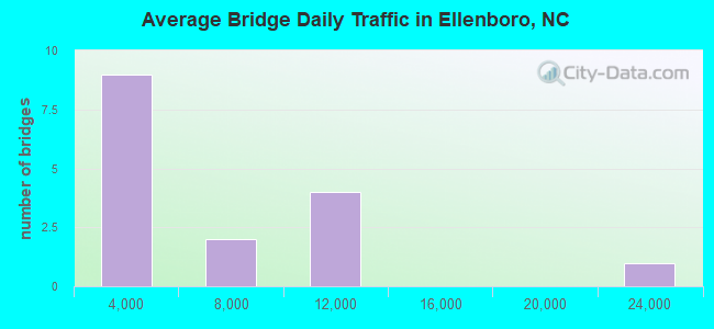
- 77,250Total average daily traffic
- 9,514Total average daily truck traffic
- National Bridge Inventory (NBI) Registered Bridges for Ellenboro
- No street view available for this location
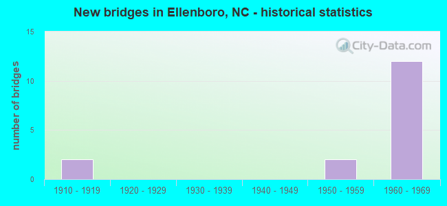
- New bridges - historical statistics
- 21910-1919
- 21950-1959
- 121960-1969
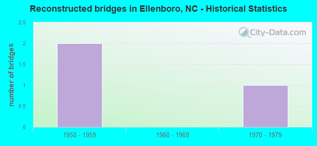
- Reconstructed bridges - Historical Statistics
- 21950-1959
- 01960-1969
- 11970-1979
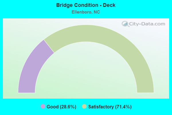
- Bridge Condition - Deck
- 28.6%Good
- 71.4%Satisfactory
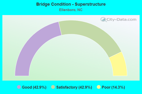
- Bridge Condition - Superstructure
- 42.9%Good
- 42.9%Satisfactory
- 14.3%Poor
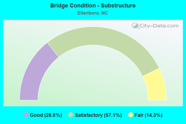
- Bridge Condition - Substructure
- 28.6%Good
- 57.1%Satisfactory
- 14.3%Fair
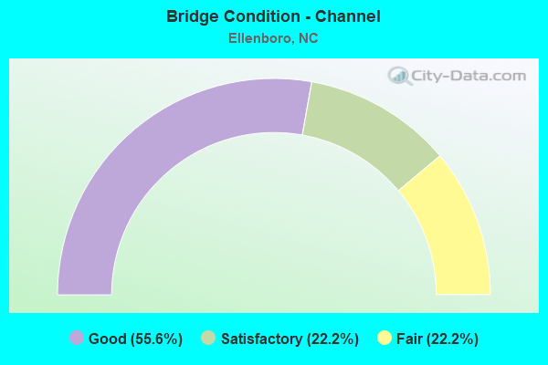
- Bridge Condition - Channel
- 55.6%Good
- 22.2%Satisfactory
- 22.2%Fair
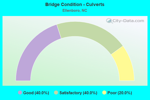
- Bridge Condition - Culverts
- 40.0%Good
- 40.0%Satisfactory
- 20.0%Poor
Find on map >> Show street view
Structure Number: 1610082, Location: 0.3MI.E.JCT.SR1767 (Lat: 35.382517, Lng: -81.752611), Route carried "on" structure: State highway 1787, Year Built: 1963, Status: Posted for load, Structure Length: 0.64m (2.10ft), Average Daily Traffic: 100 (year 2019), Truck Traffic: 6%, Average Future Daily Traffic: 200 (year 2040), Features Intersected: WEST FORK SANDY RUN CREE
Minimum Vertical Clearance: 30+ m (98+ ft), Kilometerpoint: 0.000, Lanes on structure: 2, Owner: State Highway Agency, Approaching Roadway Width: 6.0m (19.7ft), Material/Design: Steel, Design/Construction: Stringer/Multi-beam, Number Of Spans In Main Unit: 1, Length of Maximum Span: 5.7m (18.7ft), Curb or Sidewalk Widths: Left: 0.1m (0.3ft), Right: 0.1m (0.3ft), Curb-To-Curb Width: 5.7m (18.7ft), Out-to-Out Width: 6.0m (19.7ft)
Condition: Deck: Good, Superstructure: Satisfactory, Substructure: Satisfactory, Channel: Satisfactory, Operating Rating: 26.3 metric tons, Method Used To Determine Operating Rating: Load Factor (LF), Inventory Rating: 15.4 metric tons, Method Used To Determine Inventory Rating: Load Factor (LF), Structural Evaluation: Meets minimum limits, Deck Geometry: Meets minimum limits, Waterway Adequacy: Better than present minimum criteria, Approach Roadway Alignment: Equal to present minimum criteria, Bridge Posting: Required (Relationship of Operating Rating to Maximum Legal Load: > 39.9% below), Designated Inspection Frequency: Every 24 months, Inspection Date: July 2021, Deck Structure Type: Wood or Timber, Wearing Surface/Protective System: Wearing Surface: Bituminous
Find on map >> Show street view
Structure Number: 1610086, Location: .05 MI.E.JCT.SR1781 (Lat: 35.336258, Lng: -81.725083), Route carried "on" structure: State highway 1762, Year Built: 1952, Year Reconstructed: 1983, Status: Open, Structure Length: 3.23m (10.60ft), Average Daily Traffic: 950 (year 2019), Truck Traffic: 6%, Average Future Daily Traffic: 1,900 (year 2040), Features Intersected: WEST FORK SANDY RUN CREE
Minimum Vertical Clearance: 30+ m (98+ ft), Kilometerpoint: 0.000, Lanes on structure: 2, Owner: State Highway Agency, Approaching Roadway Width: 5.4m (17.7ft), Material/Design: Steel, Design/Construction: Stringer/Multi-beam, Number Of Spans In Main Unit: 3, Length of Maximum Span: 10.6m (34.8ft), Curb-To-Curb Width: 7.3m (24.0ft), Out-to-Out Width: 7.6m (24.9ft)
Condition: Deck: Satisfactory, Superstructure: Satisfactory, Substructure: Fair, Channel: Fair, Operating Rating: 66.2 metric tons, Method Used To Determine Operating Rating: Load Factor (LF), Inventory Rating: 39.0 metric tons, Method Used To Determine Inventory Rating: Load Factor (LF), Structural Evaluation: Somewhat better than minimum adequacy, Deck Geometry: Meets minimum limits, Waterway Adequacy: Better than present minimum criteria, Approach Roadway Alignment: Equal to present desirable criteria, Designated Inspection Frequency: Every 24 months, Inspection Date: April 2021, Deck Structure Type: Wood or Timber, Wearing Surface/Protective System: Wearing Surface: Bituminous
Find on map >> Show street view
Structure Number: 1610106, Location: 0.2 MI.E.JCT.SR1749 (Lat: 35.345744, Lng: -81.739133), Route carried "on" structure: State highway 1778, Year Built: 1963, Status: Posted for load, Structure Length: 1.24m (4.07ft), Average Daily Traffic: 390 (year 2016), Truck Traffic: 6%, Average Future Daily Traffic: 780 (year 2040), Features Intersected: UT TO W. FORK SANDY RUN
Minimum Vertical Clearance: 30+ m (98+ ft), Kilometerpoint: 0.000, Lanes on structure: 2, Owner: State Highway Agency, Approaching Roadway Width: 5.4m (17.7ft), Material/Design: Steel, Design/Construction: Stringer/Multi-beam, Number Of Spans In Main Unit: 1, Length of Maximum Span: 11.8m (38.7ft), Curb-To-Curb Width: 6.0m (19.7ft), Out-to-Out Width: 6.1m (20.0ft)
Condition: Deck: Satisfactory, Superstructure: Poor, Substructure: Satisfactory, Channel: Good, Operating Rating: 21.7 metric tons, Method Used To Determine Operating Rating: Load Factor (LF), Inventory Rating: 12.7 metric tons, Method Used To Determine Inventory Rating: Load Factor (LF), Structural Evaluation: Meets minimum limits, Deck Geometry: High priority of corrective action, Waterway Adequacy: Better than present minimum criteria, Approach Roadway Alignment: Equal to present desirable criteria, Bridge Posting: Required (Relationship of Operating Rating to Maximum Legal Load: > 39.9% below), Designated Inspection Frequency: Every 24 months, Inspection Date: April 2021, Deck Structure Type: Wood or Timber, Wearing Surface/Protective System: Wearing Surface: Bituminous
Find on map >> Show street view
Structure Number: 1610119, Location: .1 MI.N.JCT.SR1936 (Lat: 35.304017, Lng: -81.774278), Route carried "on" structure: State highway 1920, Year Built: 1968, Status: Open, Structure Length: 6.67m (21.88ft), Average Daily Traffic: 4,000 (year 2019), Truck Traffic: 6%, Average Future Daily Traffic: 8,000 (year 2040), Design Load: HS 15, Features Intersected: US74 BYP.
Minimum Vertical Clearance: 30+ m (98+ ft), Kilometerpoint: 0.000, Lanes on structure: 2, Lanes under structure: 4, Owner: State Highway Agency, Approaching Roadway Width: 7.3m (24.0ft), Material/Design: Steel, Design/Construction: Stringer/Multi-beam, Number Of Spans In Main Unit: 4, Length of Maximum Span: 16.7m (54.8ft), Curb or Sidewalk Widths: Left: 0.4m (1.3ft), Right: 0.4m (1.3ft), Curb-To-Curb Width: 8.5m (27.9ft), Out-to-Out Width: 10.3m (33.8ft)
Condition: Deck: Satisfactory, Superstructure: Good, Substructure: Satisfactory, Operating Rating: 45.3 metric tons, Method Used To Determine Operating Rating: Load Factor (LF), Inventory Rating: 27.2 metric tons, Method Used To Determine Inventory Rating: Load Factor (LF), Structural Evaluation: Equal to present minimum criteria, Deck Geometry: Meets minimum limits, Underclear: Somewhat better than minimum adequacy, Approach Roadway Alignment: Equal to present desirable criteria, Designated Inspection Frequency: Every 24 months, Inspection Date: August 2021, Deck Structure Type: Concrete Cast-file-Place, Wearing Surface/Protective System: Wearing Surface: Monolithic Concrete
Find on map >> Show street view
Structure Number: 1610123, Location: .4 MI.N.JCT.SR1923 (Lat: 35.300183, Lng: -81.753839), Route carried "on" structure: State highway 1921, Year Built: 1968, Status: Posted for load, Structure Length: 6.85m (22.47ft), Average Daily Traffic: 1,650 (year 2015), Truck Traffic: 6%, Average Future Daily Traffic: 3,300 (year 2040), Design Load: H 15, Features Intersected: US74BYP.
Minimum Vertical Clearance: 30+ m (98+ ft), Kilometerpoint: 0.000, Lanes on structure: 2, Lanes under structure: 4, Owner: State Highway Agency, Approaching Roadway Width: 6.0m (19.7ft), Skew: 2 degrees, Material/Design: Steel, Design/Construction: Stringer/Multi-beam, Number Of Spans In Main Unit: 4, Length of Maximum Span: 18.8m (61.7ft), Curb or Sidewalk Widths: Left: 0.3m (1.0ft), Right: 0.3m (1.0ft), Curb-To-Curb Width: 7.3m (24.0ft), Out-to-Out Width: 8.6m (28.2ft)
Condition: Deck: Satisfactory, Superstructure: Satisfactory, Substructure: Satisfactory, Operating Rating: 34.4 metric tons, Method Used To Determine Operating Rating: Load Factor (LF), Inventory Rating: 20.8 metric tons, Method Used To Determine Inventory Rating: Load Factor (LF), Structural Evaluation: Somewhat better than minimum adequacy, Deck Geometry: Meets minimum limits, Underclear: Somewhat better than minimum adequacy, Approach Roadway Alignment: Equal to present desirable criteria, Bridge Posting: Required (Relationship of Operating Rating to Maximum Legal Load: 20.0 - 29.9% below), Designated Inspection Frequency: Every 24 months, Inspection Date: July 2021, Deck Structure Type: Concrete Cast-file-Place, Wearing Surface/Protective System: Wearing Surface: Monolithic Concrete
Find on map >> Show street view
Structure Number: 1610124, Location: 0.6 MI.W.JCT.NC120 (Lat: 35.298428, Lng: -81.744175), Route carried "on" structure: Bypass US 74, Year Built: 1968, Status: Open, Structure Length: 0.70m (2.30ft), Average Daily Traffic: 21,000 (year 2019), Truck Traffic: 14%, Average Future Daily Traffic: 42,000 (year 2040), Design Load: HS 20+Mod, Features Intersected: GROG CREEK
Minimum Vertical Clearance: 30+ m (98+ ft), Kilometerpoint: 0.000, Lanes on structure: 4, Base Highway Network: Yes (Inventory Route: 2, Subroute: 74), Owner: State Highway Agency, Approaching Roadway Width: 19.5m (64.0ft), Skew: 21 degrees, Material/Design: Concrete continuous, Design/Construction: Culvert, Number Of Spans In Main Unit: 3, Length of Maximum Span: 2.1m (6.9ft)
Condition: Channel: Good, Culverts: Good, Operating Rating: 41.7 metric tons, Method Used To Determine Operating Rating: Field evaluation and documented engineering judgment, Inventory Rating: 32.6 metric tons, Method Used To Determine Inventory Rating: Field evaluation and documented engineering judgment, Structural Evaluation: Better than present minimum criteria, Waterway Adequacy: Better than present minimum criteria, Approach Roadway Alignment: Equal to present desirable criteria, Designated Inspection Frequency: Every 24 months, Inspection Date: May 2021
Find on map >> Show street view
Structure Number: 1610263, Location: .01 MI.S.JCT.SR1980 (Lat: 35.321492, Lng: -81.786583), Route carried "on" structure: State highway 1917, Year Built: 1962, Status: Open, Structure Length: 0.76m (2.49ft), Average Daily Traffic: 1,400 (year 2019), Truck Traffic: 6%, Average Future Daily Traffic: 2,800 (year 2040), Design Load: HS 20+Mod, Features Intersected: UT TO WEBBS CREEK
Minimum Vertical Clearance: 30+ m (98+ ft), Kilometerpoint: 0.000, Lanes on structure: 2, Owner: State Highway Agency, Approaching Roadway Width: 5.7m (18.7ft), Material/Design: Steel, Design/Construction: Culvert, Number Of Spans In Main Unit: 1, Length of Maximum Span: 7.6m (24.9ft)
Condition: Channel: Good, Culverts: Satisfactory, Operating Rating: 89.8 metric tons, Method Used To Determine Operating Rating: Load and Resistance Factor (LRFR), Inventory Rating: 89.8 metric tons, Method Used To Determine Inventory Rating: Load and Resistance Factor (LRFR), Structural Evaluation: Equal to present minimum criteria, Waterway Adequacy: Better than present minimum criteria, Approach Roadway Alignment: Equal to present desirable criteria, Designated Inspection Frequency: Every 24 months, Inspection Date: April 2021
Find on map >> Show street view
Structure Number: 1610324, Location: .1 MI.W.JCT.SR1774 (Lat: 35.367028, Lng: -81.766975), Route carried "on" structure: State highway 1773, Year Built: 1962, Status: Posted for load, Structure Length: 0.79m (2.59ft), Average Daily Traffic: 410 (year 2016), Truck Traffic: 6%, Average Future Daily Traffic: 820 (year 2040), Features Intersected: UT TO W. FORK SANDY RUN
Minimum Vertical Clearance: 30+ m (98+ ft), Kilometerpoint: 0.000, Lanes on structure: 2, Owner: State Highway Agency, Approaching Roadway Width: 5.1m (16.7ft), Material/Design: Steel, Design/Construction: Stringer/Multi-beam, Number Of Spans In Main Unit: 1, Length of Maximum Span: 7.3m (24.0ft), Curb or Sidewalk Widths: Left: 0.1m (0.3ft), Right: 0.1m (0.3ft), Curb-To-Curb Width: 5.8m (19.0ft), Out-to-Out Width: 6.1m (20.0ft)
Condition: Deck: Satisfactory, Superstructure: Good, Substructure: Good, Channel: Good, Operating Rating: 25.4 metric tons, Method Used To Determine Operating Rating: Load Factor (LF), Inventory Rating: 15.4 metric tons, Method Used To Determine Inventory Rating: Load Factor (LF), Structural Evaluation: Meets minimum limits, Deck Geometry: High priority of replacement, Waterway Adequacy: Better than present minimum criteria, Approach Roadway Alignment: Equal to present desirable criteria, Bridge Posting: Required (Relationship of Operating Rating to Maximum Legal Load: > 39.9% below), Designated Inspection Frequency: Every 24 months, Inspection Date: May 2021, Deck Structure Type: Wood or Timber, Wearing Surface/Protective System: Wearing Surface: Bituminous
Find on map >> Show street view
Structure Number: 1610604, Location: .3 MI.S.JCT.SR1932 (Lat: 35.309419, Lng: -81.773978), Route carried "on" structure: State highway 1920, Year Built: 1968, Status: Open, Structure Length: 4.81m (15.78ft), Average Daily Traffic: 4,000 (year 2019), Truck Traffic: 6%, Average Future Daily Traffic: 8,000 (year 2040), Design Load: HS 15, Features Intersected: ABANDONED RR
Minimum Vertical Clearance: 30+ m (98+ ft), Kilometerpoint: 0.000, Lanes on structure: 2, Owner: State Highway Agency, Approaching Roadway Width: 7.3m (24.0ft), Skew: 2 degrees, Material/Design: Steel, Design/Construction: Stringer/Multi-beam, Number Of Spans In Main Unit: 3, Length of Maximum Span: 17.0m (55.8ft), Curb or Sidewalk Widths: Left: 0.4m (1.3ft), Right: 0.4m (1.3ft), Curb-To-Curb Width: 8.5m (27.9ft), Out-to-Out Width: 10.3m (33.8ft)
Condition: Deck: Good, Superstructure: Good, Substructure: Good, Operating Rating: 48.9 metric tons, Method Used To Determine Operating Rating: Load Factor (LF), Inventory Rating: 29.0 metric tons, Method Used To Determine Inventory Rating: Load Factor (LF), Structural Evaluation: Better than present minimum criteria, Deck Geometry: Meets minimum limits, Approach Roadway Alignment: Equal to present desirable criteria, Designated Inspection Frequency: Every 24 months, Inspection Date: August 2021, Deck Structure Type: Concrete Cast-file-Place, Wearing Surface/Protective System: Wearing Surface: Monolithic Concrete
Find on map >> Show street view
Structure Number: 1610615, Location: .4 MI.S.JCT.SR1769 (Lat: 35.392539, Lng: -81.737222), Route carried "on" structure: State highway 1749, Year Built: 1955, Status: Open, Structure Length: 0.64m (2.10ft), Average Daily Traffic: 400 (year 2016), Truck Traffic: 6%, Average Future Daily Traffic: 800 (year 2040), Design Load: HS 20+Mod, Features Intersected: SANDY RUN CREEK
Minimum Vertical Clearance: 30+ m (98+ ft), Kilometerpoint: 0.000, Lanes on structure: 2, Owner: State Highway Agency, Approaching Roadway Width: 6.0m (19.7ft), Skew: 1 degrees, Material/Design: Concrete continuous, Design/Construction: Culvert, Number Of Spans In Main Unit: 2, Length of Maximum Span: 2.7m (8.9ft)
Condition: Channel: Fair, Culverts: Poor, Operating Rating: 41.7 metric tons, Method Used To Determine Operating Rating: Field evaluation and documented engineering judgment, Inventory Rating: 32.6 metric tons, Method Used To Determine Inventory Rating: Field evaluation and documented engineering judgment, Structural Evaluation: Meets minimum limits, Waterway Adequacy: Equal to present minimum criteria, Approach Roadway Alignment: Equal to present desirable criteria, Designated Inspection Frequency: Every 24 months, Inspection Date: April 2021
Find on map >> Show street view
Structure Number: 1610616, Location: 0.2 MI.N.JCT.SR1767 (Lat: 35.369947, Lng: -81.741211), Route carried "on" structure: State highway 1749, Year Built: 1919, Year Reconstructed: 1950, Status: Open, Structure Length: 0.73m (2.40ft), Average Daily Traffic: 850 (year 2019), Truck Traffic: 6%, Average Future Daily Traffic: 1,700 (year 2040), Design Load: HS 20, Features Intersected: WEST FORK SANDY RUN CREE
Minimum Vertical Clearance: 30+ m (98+ ft), Kilometerpoint: 0.000, Lanes on structure: 2, Owner: State Highway Agency, Approaching Roadway Width: 6.0m (19.7ft), Skew: 1 degrees, Material/Design: Concrete continuous, Design/Construction: Culvert, Number Of Spans In Main Unit: 2, Length of Maximum Span: 3.3m (10.8ft)
Condition: Channel: Satisfactory, Culverts: Good, Operating Rating: 41.7 metric tons, Method Used To Determine Operating Rating: Field evaluation and documented engineering judgment, Inventory Rating: 32.6 metric tons, Method Used To Determine Inventory Rating: Field evaluation and documented engineering judgment, Structural Evaluation: Better than present minimum criteria, Waterway Adequacy: Equal to present minimum criteria, Approach Roadway Alignment: Equal to present desirable criteria, Designated Inspection Frequency: Every 24 months, Inspection Date: April 2021
Find on map >> Show street view
Structure Number: 1610617, Location: .05 MI.N.JCT.SR1777 (Lat: 35.343297, Lng: -81.742639), Route carried "on" structure: State highway 1749, Year Built: 1919, Year Reconstructed: 1950, Status: Open, Structure Length: 0.76m (2.49ft), Average Daily Traffic: 2,100 (year 2012), Truck Traffic: 6%, Average Future Daily Traffic: 4,200 (year 2040), Design Load: HS 20, Features Intersected: UT TO W.FRK.SANDY RUN CR
Minimum Vertical Clearance: 30+ m (98+ ft), Kilometerpoint: 0.000, Lanes on structure: 2, Owner: State Highway Agency, Approaching Roadway Width: 6.0m (19.7ft), Material/Design: Concrete continuous, Design/Construction: Culvert, Number Of Spans In Main Unit: 3, Length of Maximum Span: 2.4m (7.9ft)
Condition: Channel: Good, Culverts: Satisfactory, Operating Rating: 41.7 metric tons, Method Used To Determine Operating Rating: Field evaluation and documented engineering judgment, Inventory Rating: 32.6 metric tons, Method Used To Determine Inventory Rating: Field evaluation and documented engineering judgment, Structural Evaluation: Equal to present minimum criteria, Waterway Adequacy: Better than present minimum criteria, Approach Roadway Alignment: Equal to present desirable criteria, Designated Inspection Frequency: Every 24 months, Inspection Date: April 2021
Find on map >> Show street view
Structure Number: 1610119, Location: .1 MI.N.JCT.SR1936 (Lat: 35.304017, Lng: -81.774278), Route carried "under" structure: Bypass US 74, Year Built: 1968, Structure Length: 0. m, Average Daily Traffic: 10,000 (year 2015), Truck Traffic: 14%, Features Intersected: SR1920
Minimum Vertical Clearance: 4.57m (14.99ft), Kilometerpoint: 56.998, Lanes on structure: 2, Lanes under structure: 2, Material/Design: Steel, Design/Construction: Stringer/Multi-beam, Length of Maximum Span: 16.7m (54.8ft)
Find on map >> Show street view
Structure Number: 1610123, Location: .4 MI.N.JCT.SR1923 (Lat: 35.300183, Lng: -81.753839), Route carried "under" structure: Bypass US 74, Year Built: 1968, Structure Length: 0. m, Average Daily Traffic: 10,000 (year 2015), Truck Traffic: 14%, Features Intersected: SR1921
Minimum Vertical Clearance: 4.67m (15.32ft), Kilometerpoint: 57.364, Lanes on structure: 2, Lanes under structure: 2, Material/Design: Steel, Design/Construction: Stringer/Multi-beam, Length of Maximum Span: 18.8m (61.7ft)
Find on map >> Show street view
Structure Number: 1610123, Location: .4 MI.N.JCT.SR1923 (Lat: 35.300183, Lng: -81.753839), Route carried "under" structure: Bypass US 74, Year Built: 1968, Structure Length: 0. m, Average Daily Traffic: 10,000 (year 2015), Truck Traffic: 14%, Features Intersected: SR1921
Minimum Vertical Clearance: 4.87m (15.98ft), Kilometerpoint: 57.364, Lanes on structure: 2, Lanes under structure: 2, Material/Design: Steel, Design/Construction: Stringer/Multi-beam, Length of Maximum Span: 18.8m (61.7ft)