Bridge Statistics for Emigsville, Pennsylvania (PA)
Condition, Traffic, Stress, Structural Evaluation, Project Costs
- National Bridge Inventory (NBI) Statistics
- 23Number of bridges
- 135ft / 40.7mTotal length
- $2,947,000Total costs
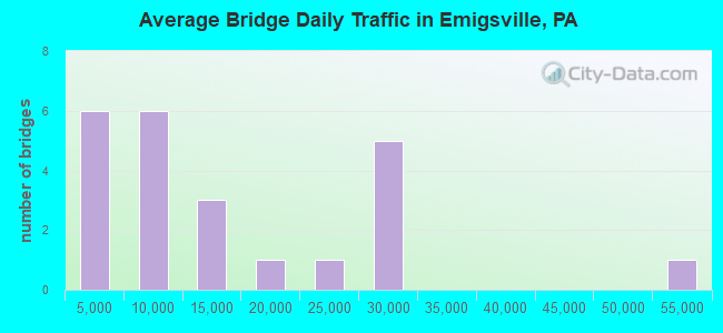
- 322,706Total average daily traffic
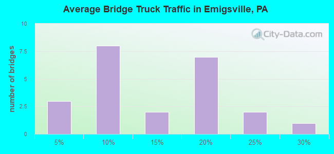
- 43,337Total average daily truck traffic
- National Bridge Inventory (NBI) Registered Bridges for Emigsville
- No street view available for this location
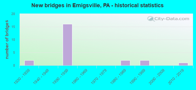
- New bridges - historical statistics
- 21930-1939
- 161950-1959
- 21980-1989
- 21990-1999
- 12010-2019
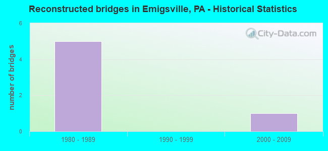
- Reconstructed bridges - Historical Statistics
- 51980-1989
- 01990-1999
- 12000-2009
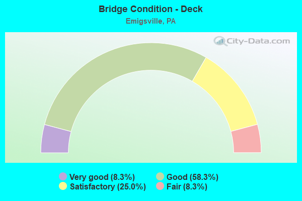
- Bridge Condition - Deck
- 8.3%Very good
- 58.3%Good
- 25.0%Satisfactory
- 8.3%Fair
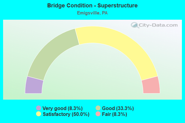
- Bridge Condition - Superstructure
- 8.3%Very good
- 33.3%Good
- 50.0%Satisfactory
- 8.3%Fair
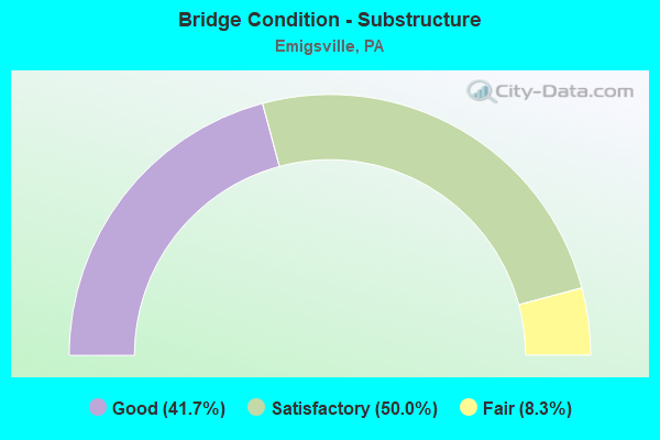
- Bridge Condition - Substructure
- 41.7%Good
- 50.0%Satisfactory
- 8.3%Fair
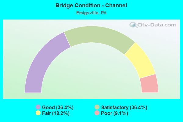
- Bridge Condition - Channel
- 36.4%Good
- 36.4%Satisfactory
- 18.2%Fair
- 9.1%Poor
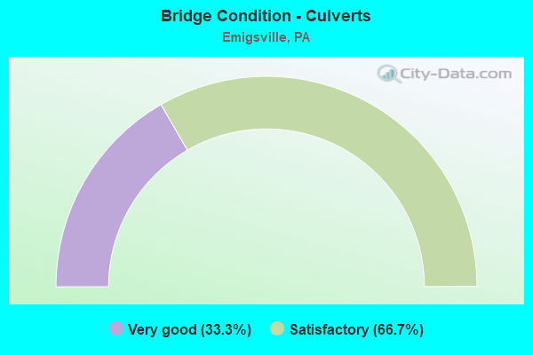
- Bridge Condition - Culverts
- 33.3%Very good
- 66.7%Satisfactory
Find on map >> Show street view
Structure Number: 37349, Location: 2 MI NE PLEASUREVILLE (Lat: 40.018664, Lng: -76.693364), Route carried "on" structure: State highway 24, Year Built: 1933, Year Reconstructed: 1987, Status: Open, Structure Length: 5.06m (16.60ft), Average Daily Traffic: 5,452 (year 2020), Truck Traffic: 24%, Average Future Daily Traffic: 9,853 (year 2032), Design Load: H 20, Features Intersected: CODORUS CREEK
Minimum Vertical Clearance: 30+ m (98+ ft), Kilometerpoint: 38.766, Lanes on structure: 2, Owner: State Highway Agency, Approaching Roadway Width: 7.3m (24.0ft), Skew: 1 degrees, Material/Design: Steel, Design/Construction: Stringer/Multi-beam, Number Of Spans In Main Unit: 3, Length of Maximum Span: 16.5m (54.1ft), Curb or Sidewalk Widths: Left: 0.2m (0.7ft), Right: 0.2m (0.7ft), Curb-To-Curb Width: 6.9m (22.6ft), Out-to-Out Width: 7.6m (24.9ft)
Condition: Deck: Satisfactory, Superstructure: Satisfactory, Substructure: Satisfactory, Channel: Fair, Operating Rating: 70.8 metric tons, Method Used To Determine Operating Rating: Load Factor (LF), Inventory Rating: 42.6 metric tons, Method Used To Determine Inventory Rating: Load Factor (LF), Structural Evaluation: Equal to present minimum criteria, Deck Geometry: High priority of replacement, Waterway Adequacy: Equal to present minimum criteria, Approach Roadway Alignment: Better than present minimum criteria, Length Of Structure Improvement: 6.00m (19.69ft), Designated Inspection Frequency: Every 24 months, Inspection Date: September 2021, Bridge Improvement Cost: $24,000, Roadway Improvement Cost: $70,000, Total Project Cost: $322,000, Deck Structure Type: Concrete Cast-file-Place, Wearing Surface/Protective System: Wearing Surface: Monolithic Concrete, Deck Protection: Epoxy Coated Reinforcing
Find on map >> Show street view
Structure Number: 3735, Location: 2 MI NE PLEASUREVILLE (Lat: 40.019131, Lng: -76.693833), Route carried "on" structure: State highway 24, Year Built: 1933, Year Reconstructed: 1987, Status: Open, Structure Length: 1.16m (3.81ft), Average Daily Traffic: 5,452 (year 2020), Truck Traffic: 24%, Average Future Daily Traffic: 9,853 (year 2032), Design Load: HS 25 or greater, Features Intersected: MILL RACE TO CODORUS CR
Minimum Vertical Clearance: 30+ m (98+ ft), Kilometerpoint: 38.766, Lanes on structure: 2, Owner: State Highway Agency, Approaching Roadway Width: 7.3m (24.0ft), Skew: 1 degrees, Material/Design: Prestressed concrete, Design/Construction: Box Beam or Girders - Single/Spread, Number Of Spans In Main Unit: 1, Length of Maximum Span: 11.3m (37.1ft), Curb or Sidewalk Widths: Left: 0.2m (0.7ft), Right: 0.2m (0.7ft), Curb-To-Curb Width: 6.9m (22.6ft), Out-to-Out Width: 7.6m (24.9ft)
Condition: Deck: Good, Superstructure: Good, Substructure: Fair, Channel: Satisfactory, Operating Rating: 89.8 metric tons, Method Used To Determine Operating Rating: Load Factor (LF), Inventory Rating: 45.4 metric tons, Method Used To Determine Inventory Rating: Load Factor (LF), Structural Evaluation: Somewhat better than minimum adequacy, Deck Geometry: High priority of replacement, Waterway Adequacy: Better than present minimum criteria, Approach Roadway Alignment: Somewhat better than minimum adequacy, Length Of Structure Improvement: 1.80m (5.91ft), Designated Inspection Frequency: Every 24 months, Inspection Date: September 2021, Bridge Improvement Cost: $3,000, Roadway Improvement Cost: $9,000, Total Project Cost: $43,000, Deck Structure Type: Concrete Cast-file-Place, Wearing Surface/Protective System: Wearing Surface: Monolithic Concrete, Deck Protection: Epoxy Coated Reinforcing
Find on map >> Show street view
Structure Number: 37449, Location: .2 MI N OF I-83 EXIT-21 (Lat: 39.987658, Lng: -76.733056), Route carried "on" structure: Interstate 83, Year Built: 1957, Status: Open, Structure Length: 0.85m (2.79ft), Average Daily Traffic: 51,776 (year 2020), Truck Traffic: 15%, Average Future Daily Traffic: 65,922 (year 2032), Design Load: HS 20, Features Intersected: TRIB TO CODORUS CREEK
Minimum Vertical Clearance: 30+ m (98+ ft), Kilometerpoint: 33.713, Lanes on structure: 4, Base Highway Network: Yes, Owner: State Highway Agency, Approaching Roadway Width: 21.9m (71.9ft), Skew: 31 degrees, Material/Design: Concrete, Design/Construction: Culvert, Number Of Spans In Main Unit: 1, Length of Maximum Span: 8.5m (27.9ft)
Condition: Channel: Satisfactory, Culverts: Satisfactory, Operating Rating: 69.9 metric tons, Method Used To Determine Operating Rating: Allowable Stress (AS), Inventory Rating: 46.3 metric tons, Method Used To Determine Inventory Rating: Allowable Stress (AS), Structural Evaluation: Equal to present minimum criteria, Waterway Adequacy: Superior to present desirable criteria, Approach Roadway Alignment: Equal to present desirable criteria, Length Of Structure Improvement: 1.50m (4.92ft), Designated Inspection Frequency: Every 48 months, Inspection Date: September 2019
Find on map >> Show street view
Structure Number: 37451, Location: 1 MI S OF EXIT-11, I-83 (Lat: 40.006089, Lng: -76.738556), Route carried "on" structure: State highway , Year Built: 1957, Year Reconstructed: 1994, Status: Open, Structure Length: 5.61m (18.41ft), Average Daily Traffic: 1,729 (year 2021), Truck Traffic: 1%, Average Future Daily Traffic: 2,433 (year 2032), Design Load: HS 25 or greater, Features Intersected: I-83; SR 0083, Facility Carried by Structure: SR 4050; T-943
Minimum Vertical Clearance: 30+ m (98+ ft), Kilometerpoint: 0.000, Lanes on structure: 2, Lanes under structure: 8, Owner: State Highway Agency, Approaching Roadway Width: 7.6m (24.9ft), Material/Design: Steel continuous, Design/Construction: Stringer/Multi-beam, Number Of Spans In Main Unit: 3, Length of Maximum Span: 27.4m (89.9ft), Curb or Sidewalk Widths: Left: 1.5m (4.9ft), Right: 0.2m (0.7ft), Curb-To-Curb Width: 9.1m (29.9ft), Out-to-Out Width: 11.6m (38.1ft)
Condition: Deck: Good, Superstructure: Satisfactory, Substructure: Satisfactory, Operating Rating: 63.5 metric tons, Method Used To Determine Operating Rating: Load Factor (LF), Inventory Rating: 38.1 metric tons, Method Used To Determine Inventory Rating: Load Factor (LF), Structural Evaluation: Equal to present minimum criteria, Deck Geometry: Somewhat better than minimum adequacy, Underclear: High priority of corrective action, Approach Roadway Alignment: Equal to present desirable criteria, Length Of Structure Improvement: 6.60m (21.65ft), Designated Inspection Frequency: Every 48 months, Inspection Date: November 2019, Deck Structure Type: Concrete Cast-file-Place, Wearing Surface/Protective System: Wearing Surface: Monolithic Concrete, Deck Protection: Epoxy Coated Reinforcing
Find on map >> Show street view
Structure Number: 37452, Location: 0.3 MI S OF EXIT-11, I-83 (Lat: 40.015667, Lng: -76.741308), Route carried "on" structure: State highway , Year Built: 1957, Year Reconstructed: 1994, Status: Open, Structure Length: 6.13m (20.11ft), Average Daily Traffic: 2,688 (year 2021), Truck Traffic: 3%, Average Future Daily Traffic: 2,973 (year 2032), Design Load: HS 20, Features Intersected: I-83; SR 0083, Facility Carried by Structure: T-839;SINK SPRG LA
Minimum Vertical Clearance: 30+ m (98+ ft), Kilometerpoint: 0.000, Lanes on structure: 2, Lanes under structure: 8, Owner: State Highway Agency, Approaching Roadway Width: 8.5m (27.9ft), Skew: 2 degrees, Material/Design: Steel continuous, Design/Construction: Stringer/Multi-beam, Number Of Spans In Main Unit: 3, Length of Maximum Span: 29.0m (95.1ft), Curb or Sidewalk Widths: Left: 0.3m (1.0ft), Right: 0.3m (1.0ft), Curb-To-Curb Width: 8.5m (27.9ft), Out-to-Out Width: 9.8m (32.2ft)
Condition: Deck: Good, Superstructure: Satisfactory, Substructure: Satisfactory, Operating Rating: 62.6 metric tons, Method Used To Determine Operating Rating: Load Factor (LF), Inventory Rating: 37.2 metric tons, Method Used To Determine Inventory Rating: Load Factor (LF), Structural Evaluation: Equal to present minimum criteria, Deck Geometry: Meets minimum limits, Underclear: Equal to present minimum criteria, Approach Roadway Alignment: Equal to present desirable criteria, Length Of Structure Improvement: 7.00m (22.97ft), Designated Inspection Frequency: Every 48 months, Inspection Date: November 2019, Deck Structure Type: Concrete Cast-file-Place, Wearing Surface/Protective System: Wearing Surface: Monolithic Concrete, Deck Protection: Epoxy Coated Reinforcing
Find on map >> Show street view
Structure Number: 37501, Location: I-83 N. GEO. ST. (Lat: 39.990514, Lng: -76.735292), Route carried "on" structure: Business State highway 181, Year Built: 1957, Status: Open, Structure Length: 0.94m (3.08ft), Average Daily Traffic: 14,713 (year 2020), Truck Traffic: 9%, Average Future Daily Traffic: 19,687 (year 2032), Design Load: H 20, Features Intersected: TRIB TO CODORUS CREEK
Minimum Vertical Clearance: 30+ m (98+ ft), Kilometerpoint: 0.669, Lanes on structure: 5, Base Highway Network: Yes, Owner: State Highway Agency, Approaching Roadway Width: 20.7m (67.9ft), Skew: 2 degrees, Material/Design: Concrete, Design/Construction: Tee Beam, Number Of Spans In Main Unit: 1, Length of Maximum Span: 8.8m (28.9ft), Curb-To-Curb Width: 47.7m (156.5ft), Out-to-Out Width: 51.9m (170.3ft)
Condition: Deck: Satisfactory, Superstructure: Satisfactory, Substructure: Good, Channel: Good, Operating Rating: 68.9 metric tons, Method Used To Determine Operating Rating: Load Factor (LF), Inventory Rating: 40.8 metric tons, Method Used To Determine Inventory Rating: Load Factor (LF), Structural Evaluation: Equal to present minimum criteria, Deck Geometry: Superior to present desirable criteria, Waterway Adequacy: Equal to present minimum criteria, Approach Roadway Alignment: Equal to present desirable criteria, Length Of Structure Improvement: 1.60m (5.25ft), Designated Inspection Frequency: Every 24 months, Inspection Date: October 2019, Bridge Improvement Cost: $19,000, Roadway Improvement Cost: $56,000, Total Project Cost: $257,000, Deck Structure Type: Concrete Cast-file-Place, Wearing Surface/Protective System: Wearing Surface: Bituminous
Find on map >> Show street view
Structure Number: 37556, Location: EXIT-11, EMIGSVILLE, I-83 (Lat: 40.020539, Lng: -76.742772), Route carried "on" structure: State highway 238, Year Built: 1957, Year Reconstructed: 1986, Status: Open, Structure Length: 5.58m (18.31ft), Average Daily Traffic: 18,124 (year 2022), Truck Traffic: 10%, Average Future Daily Traffic: 32,140 (year 2032), Design Load: HS 20, Features Intersected: I-83; SR 0083
Minimum Vertical Clearance: 30+ m (98+ ft), Kilometerpoint: 5.216, Lanes on structure: 2, Lanes under structure: 4, Owner: State Highway Agency, Approaching Roadway Width: 10.4m (34.1ft), Material/Design: Steel continuous, Design/Construction: Stringer/Multi-beam, Number Of Spans In Main Unit: 3, Length of Maximum Span: 27.4m (89.9ft), Curb or Sidewalk Widths: Left: 0.2m (0.7ft), Right: 0.2m (0.7ft), Curb-To-Curb Width: 9.1m (29.9ft), Out-to-Out Width: 10.1m (33.1ft)
Condition: Deck: Satisfactory, Superstructure: Satisfactory, Substructure: Satisfactory, Operating Rating: 42.6 metric tons, Method Used To Determine Operating Rating: Load Factor (LF), Inventory Rating: 25.4 metric tons, Method Used To Determine Inventory Rating: Load Factor (LF), Structural Evaluation: Equal to present minimum criteria, Deck Geometry: High priority of corrective action, Underclear: Equal to present minimum criteria, Approach Roadway Alignment: Equal to present desirable criteria, Length Of Structure Improvement: 6.50m (21.33ft), Designated Inspection Frequency: Every 24 months, Inspection Date: October 2019, Deck Structure Type: Concrete Cast-file-Place, Wearing Surface/Protective System: Wearing Surface: Bituminous, Membrane: Other
Find on map >> Show street view
Structure Number: 37557, Location: 0.5 MI.E. OF EMIGSVILLE (Lat: 40.023731, Lng: -76.729058), Route carried "on" structure: State highway 238, Year Built: 1994, Status: Open, Structure Length: 1.16m (3.81ft), Average Daily Traffic: 10,276 (year 2020), Truck Traffic: 14%, Average Future Daily Traffic: 17,126 (year 2032), Design Load: HS 25 or greater, Features Intersected: TRIB CODORUS CREEK
Minimum Vertical Clearance: 30+ m (98+ ft), Kilometerpoint: 6.262, Lanes on structure: 2, Owner: State Highway Agency, Approaching Roadway Width: 11.3m (37.1ft), Material/Design: Prestressed concrete, Design/Construction: Box Beam or Girders - Single/Spread, Number Of Spans In Main Unit: 1, Length of Maximum Span: 11.0m (36.1ft), Curb or Sidewalk Widths: Left: 0.2m (0.7ft), Right: 0.2m (0.7ft), Curb-To-Curb Width: 10.4m (34.1ft), Out-to-Out Width: 11.4m (37.4ft)
Condition: Deck: Good, Superstructure: Very good, Substructure: Satisfactory, Channel: Satisfactory, Operating Rating: 68.9 metric tons, Method Used To Determine Operating Rating: Load Factor (LF), Inventory Rating: 40.8 metric tons, Method Used To Determine Inventory Rating: Load Factor (LF), Structural Evaluation: Equal to present minimum criteria, Deck Geometry: Meets minimum limits, Waterway Adequacy: Equal to present desirable criteria, Approach Roadway Alignment: Equal to present desirable criteria, Length Of Structure Improvement: 1.80m (5.91ft), Designated Inspection Frequency: Every 48 months, Inspection Date: August 2019, Deck Structure Type: Concrete Cast-file-Place, Wearing Surface/Protective System: Wearing Surface: Monolithic Concrete, Deck Protection: Epoxy Coated Reinforcing
Find on map >> Show street view
Structure Number: 37642, Location: 1.0 MI.S.W. OF ZIONS VIEW (Lat: 40.041614, Lng: -76.777447), Route carried "on" structure: State highway 921, Year Built: 1983, Status: Open, Structure Length: 0.85m (2.79ft), Average Daily Traffic: 7,436 (year 2020), Truck Traffic: 5%, Average Future Daily Traffic: 10,030 (year 2032), Design Load: HS 20+Mod, Features Intersected: OAK RUN
Minimum Vertical Clearance: 30+ m (98+ ft), Kilometerpoint: 7.929, Lanes on structure: 2, Owner: State Highway Agency, Approaching Roadway Width: 7.6m (24.9ft), Material/Design: Concrete, Design/Construction: Channel Beam, Number Of Spans In Main Unit: 1, Length of Maximum Span: 8.2m (26.9ft), Curb or Sidewalk Widths: Left: 0.2m (0.7ft), Right: 0.2m (0.7ft), Curb-To-Curb Width: 9.0m (29.5ft), Out-to-Out Width: 10.2m (33.5ft)
Condition: Deck: Good, Superstructure: Good, Substructure: Good, Channel: Satisfactory, Operating Rating: 69.9 metric tons, Method Used To Determine Operating Rating: Allowable Stress (AS), Inventory Rating: 43.5 metric tons, Method Used To Determine Inventory Rating: Allowable Stress (AS), Structural Evaluation: Better than present minimum criteria, Deck Geometry: High priority of replacement, Waterway Adequacy: Somewhat better than minimum adequacy, Approach Roadway Alignment: Equal to present desirable criteria, Length Of Structure Improvement: 1.50m (4.92ft), Designated Inspection Frequency: Every 24 months, Inspection Date: November 2019, Bridge Improvement Cost: $4,000, Roadway Improvement Cost: $11,000, Total Project Cost: $51,000, Wearing Surface/Protective System: Wearing Surface: Bituminous, Membrane: Preformed Fabric
Find on map >> Show street view
Structure Number: 37658, Location: 0.5 MI.N. OF EMIGSVILLE (Lat: 40.024900, Lng: -76.728200), Route carried "on" structure: State highway , Year Built: 1987, Status: Open, Structure Length: 1.86m (6.10ft), Average Daily Traffic: 2,211 (year 2020), Truck Traffic: 1%, Average Future Daily Traffic: 3,370 (year 2032), Design Load: HS 25 or greater, Features Intersected: Norfolk Southern RR, Facility Carried by Structure: SR 1010
Minimum Vertical Clearance: 30+ m (98+ ft), Kilometerpoint: 0.000, Lanes on structure: 2, Owner: Railroad, Approaching Roadway Width: 8.2m (26.9ft), Skew: 6 degrees, Material/Design: Prestressed concrete, Design/Construction: Box Beam or Girders - Multiple, Number Of Spans In Main Unit: 1, Length of Maximum Span: 18.3m (60.0ft), Curb or Sidewalk Widths: Left: 0.2m (0.7ft), Right: 0.2m (0.7ft), Curb-To-Curb Width: 9.1m (29.9ft), Out-to-Out Width: 9.9m (32.5ft)
Condition: Deck: Good, Superstructure: Good, Substructure: Satisfactory, Inventory Rating: 70.8 metric tons, Method Used To Determine Inventory Rating: Load Factor (LF), Structural Evaluation: Equal to present minimum criteria, Deck Geometry: Meets minimum limits, Underclear: High priority of corrective action, Approach Roadway Alignment: Somewhat better than minimum adequacy, Length Of Structure Improvement: 2.60m (8.53ft), Designated Inspection Frequency: Every 24 months, Inspection Date: September 2021, Deck Structure Type: Concrete Cast-file-Place, Wearing Surface/Protective System: Wearing Surface: Monolithic Concrete, Deck Protection: Epoxy Coated Reinforcing
Find on map >> Show street view
Structure Number: 3766, Location: 0.5 MI S EMIGSVILLE (Lat: 40.018506, Lng: -76.725567), Route carried "on" structure: State highway , Year Built: 1956, Status: Open, Structure Length: 0.82m (2.69ft), Average Daily Traffic: 9,001 (year 2021), Truck Traffic: 9%, Average Future Daily Traffic: 12,937 (year 2032), Design Load: HS 20, Features Intersected: TRIB CODORUS CREEK, Facility Carried by Structure: SR 1012
Minimum Vertical Clearance: 30+ m (98+ ft), Kilometerpoint: 0.000, Lanes on structure: 2, Owner: State Highway Agency, Approaching Roadway Width: 8.8m (28.9ft), Skew: 1 degrees, Material/Design: Prestressed concrete, Design/Construction: Box Beam or Girders - Multiple, Number Of Spans In Main Unit: 1, Length of Maximum Span: 7.3m (24.0ft), Curb or Sidewalk Widths: Left: 0.2m (0.7ft), Right: 0.2m (0.7ft), Curb-To-Curb Width: 12.5m (41.0ft), Out-to-Out Width: 13.0m (42.7ft)
Condition: Deck: Fair, Superstructure: Fair, Substructure: Good, Channel: Poor, Inventory Rating: 71.7 metric tons, Method Used To Determine Inventory Rating: Load Factor (LF), Structural Evaluation: Somewhat better than minimum adequacy, Deck Geometry: Somewhat better than minimum adequacy, Waterway Adequacy: Meets minimum limits, Approach Roadway Alignment: Equal to present desirable criteria, Length Of Structure Improvement: 1.40m (4.59ft), Designated Inspection Frequency: Every 24 months, Inspection Date: September 2021, Bridge Improvement Cost: $12,000, Roadway Improvement Cost: $35,000, Total Project Cost: $160,000, Deck Structure Type: Other, Wearing Surface/Protective System: Wearing Surface: Bituminous
Find on map >> Show street view
Structure Number: 37661, Location: 0.5 MI E EMIGSVILLE (Lat: 40.016831, Lng: -76.720250), Route carried "on" structure: State highway , Year Built: 1956, Status: Open, Structure Length: 0.85m (2.79ft), Average Daily Traffic: 9,001 (year 2021), Truck Traffic: 9%, Average Future Daily Traffic: 12,937 (year 2032), Design Load: HS 20, Features Intersected: TRIB CODORUS CREEK, Facility Carried by Structure: SR 1012 Emig Rd.
Minimum Vertical Clearance: 30+ m (98+ ft), Kilometerpoint: 0.787, Lanes on structure: 2, Owner: State Highway Agency, Approaching Roadway Width: 11.9m (39.0ft), Skew: 3 degrees, Material/Design: Concrete, Design/Construction: Culvert, Number Of Spans In Main Unit: 1, Length of Maximum Span: 8.5m (27.9ft)
Condition: Channel: Good, Culverts: Satisfactory, Operating Rating: 69.9 metric tons, Method Used To Determine Operating Rating: Allowable Stress (AS), Inventory Rating: 46.3 metric tons, Method Used To Determine Inventory Rating: Allowable Stress (AS), Structural Evaluation: Equal to present minimum criteria, Waterway Adequacy: Superior to present desirable criteria, Approach Roadway Alignment: Equal to present desirable criteria, Length Of Structure Improvement: 1.50m (4.92ft), Designated Inspection Frequency: Every 48 months, Inspection Date: September 2019
Find on map >> Show street view
Structure Number: 37663, Location: 2 MI E OF EMIGSVILLE (Lat: 40.010894, Lng: -76.710033), Route carried "on" structure: State highway , Year Built: 1956, Year Reconstructed: 2013, Status: Open, Structure Length: 8.08m (26.51ft), Average Daily Traffic: 9,001 (year 2021), Truck Traffic: 9%, Average Future Daily Traffic: 12,937 (year 2032), Design Load: HS 20, Features Intersected: CODORUS CREEK, Facility Carried by Structure: SR 1012
Minimum Vertical Clearance: 30+ m (98+ ft), Kilometerpoint: 1.352, Lanes on structure: 2, Owner: State Highway Agency, Approaching Roadway Width: 7.9m (25.9ft), Skew: 1 degrees, Material/Design: Steel continuous, Design/Construction: Stringer/Multi-beam, Number Of Spans In Main Unit: 3, Length of Maximum Span: 29.3m (96.1ft), Curb-To-Curb Width: 8.5m (27.9ft), Out-to-Out Width: 9.4m (30.8ft)
Condition: Deck: Very good, Superstructure: Satisfactory, Substructure: Good, Channel: Good, Inventory Rating: 86.2 metric tons, Method Used To Determine Inventory Rating: Load Factor (LF), Structural Evaluation: Equal to present minimum criteria, Deck Geometry: Meets minimum limits, Waterway Adequacy: Better than present minimum criteria, Approach Roadway Alignment: Equal to present desirable criteria, Length Of Structure Improvement: 9.10m (29.86ft), Designated Inspection Frequency: Every 24 months, Underwater Inspection Frequency: Every 60 months, Inspection Date: October 2019, Underwater Inspection Date: April 2020, Bridge Improvement Cost: $157,000, Roadway Improvement Cost: $461,000, Total Project Cost: $2,114,000, Deck Structure Type: Concrete Cast-file-Place, Wearing Surface/Protective System: Deck Protection: Epoxy Coated Reinforcing
Find on map >> Show street view
Structure Number: 38167, Location: 1.7E CMIGSVL/TR.CODORUSCR (Lat: 40.017961, Lng: -76.714753), Route carried "on" structure: City street , Year Built: 1992, Status: Open, Structure Length: 0.94m (3.08ft), Average Daily Traffic: 1,500 (year 1997), Truck Traffic: 25%, Average Future Daily Traffic: 2,703 (year 2032), Design Load: HS 25 or greater, Features Intersected: TRIB. TO CODORUS CREEK, Facility Carried by Structure: MUNDIS RACE ROAD
Minimum Vertical Clearance: 30+ m (98+ ft), Kilometerpoint: 0.000, Lanes on structure: 2, Owner: Town or Township Highway Agency, Approaching Roadway Width: 7.3m (24.0ft), Skew: 3 degrees, Material/Design: Prestressed concrete, Design/Construction: Box Beam or Girders - Multiple, Number Of Spans In Main Unit: 1, Length of Maximum Span: 8.8m (28.9ft), Curb-To-Curb Width: 7.9m (25.9ft), Out-to-Out Width: 8.8m (28.9ft)
Condition: Deck: Good, Superstructure: Good, Substructure: Good, Channel: Fair, Operating Rating: 96.2 metric tons, Method Used To Determine Operating Rating: Load Factor (LF), Inventory Rating: 55.3 metric tons, Method Used To Determine Inventory Rating: Load Factor (LF), Structural Evaluation: Better than present minimum criteria, Deck Geometry: Meets minimum limits, Waterway Adequacy: Superior to present desirable criteria, Approach Roadway Alignment: Better than present minimum criteria, Length Of Structure Improvement: 1.60m (5.25ft), Designated Inspection Frequency: Every 24 months, Inspection Date: March 2021, Deck Structure Type: Concrete Cast-file-Place, Wearing Surface/Protective System: Wearing Surface: Monolithic Concrete, Deck Protection: Epoxy Coated Reinforcing
Find on map >> Show street view
Structure Number: 47453, Location: INTER LR 250 AND LR 66021 (Lat: 40.022358, Lng: -76.728050), Route carried "on" structure: State highway 181, Year Built: 2012, Status: Open, Structure Length: 0.79m (2.59ft), Average Daily Traffic: 13,774 (year 2021), Truck Traffic: 7%, Average Future Daily Traffic: 20,674 (year 2032), Design Load: HL 93, Features Intersected: TRIB TO CODORUS CREEK
Minimum Vertical Clearance: 30+ m (98+ ft), Kilometerpoint: 3.965, Lanes on structure: 2, Owner: State Highway Agency, Approaching Roadway Width: 8.8m (28.9ft), Skew: 3 degrees, Material/Design: Concrete, Design/Construction: Culvert, Number Of Spans In Main Unit: 1, Length of Maximum Span: 7.0m (23.0ft)
Condition: Channel: Good, Culverts: Very good, Operating Rating: 58.0 metric tons, Method Used To Determine Operating Rating: Assigned ratings based on Load and Resistance Factor Design (LRFD) reported by rating factor (RF) using HL93 loadings, Inventory Rating: 36.3 metric tons, Method Used To Determine Inventory Rating: Assigned ratings based on Load and Resistance Factor Design (LRFD) reported by rating factor (RF) using HL93 loadings, Structural Evaluation: Equal to present desirable criteria, Waterway Adequacy: Equal to present minimum criteria, Approach Roadway Alignment: Equal to present desirable criteria, Designated Inspection Frequency: Every 48 months, Inspection Date: September 2019
Find on map >> Show street view
Structure Number: 3745, Location: EXIT-22, I-83 & PA 181 (Lat: 39.991569, Lng: -76.734419), Route carried "under" structure: State highway 181, Year Built: 1957, Structure Length: 0. m, Average Daily Traffic: 3,350 (year 2020), Truck Traffic: 8%, Features Intersected: 181 George St, Facility Carried by Structure: Bypass Other road
Minimum Vertical Clearance: 4.70m (15.42ft), Kilometerpoint: 0.669, Lanes on structure: 4, Lanes under structure: 4, Material/Design: Steel continuous, Design/Construction: Stringer/Multi-beam, Length of Maximum Span: 26.5m (86.9ft)
Find on map >> Show street view
Structure Number: 3745, Location: EXIT-22, I-83 & PA 181 (Lat: 39.991569, Lng: -76.734419), Route carried "under" structure: State highway 181, Year Built: 1957, Structure Length: 0. m, Average Daily Traffic: 3,350 (year 2020), Truck Traffic: 8%, Features Intersected: 181 George St, Facility Carried by Structure: Bypass Other road
Minimum Vertical Clearance: 4.67m (15.32ft), Kilometerpoint: 0.663, Lanes on structure: 4, Lanes under structure: 4, Material/Design: Steel continuous, Design/Construction: Stringer/Multi-beam, Length of Maximum Span: 26.5m (86.9ft)
Find on map >> Show street view
Structure Number: 37451, Location: 1 MI S OF EXIT-11, I-83 (Lat: 40.006089, Lng: -76.738556), Route carried "under" structure: Interstate 83, Year Built: 1957, Structure Length: 0. m, Average Daily Traffic: 25,316 (year 2020), Truck Traffic: 16%, Features Intersected: I-83; SR 0083, Facility Carried by Structure: SR 4050; T-943
Minimum Vertical Clearance: 5.44m (17.85ft), Kilometerpoint: 36.127, Lanes on structure: 2, Lanes under structure: 4, Material/Design: Steel continuous, Design/Construction: Stringer/Multi-beam, Length of Maximum Span: 27.4m (89.9ft)
Find on map >> Show street view
Structure Number: 37451, Location: 1 MI S OF EXIT-11, I-83 (Lat: 40.006089, Lng: -76.738556), Route carried "under" structure: Interstate 83, Year Built: 1957, Structure Length: 0. m, Average Daily Traffic: 26,460 (year 2020), Truck Traffic: 15%, Features Intersected: I-83; SR 0083, Facility Carried by Structure: SR 4050; T-943
Minimum Vertical Clearance: 5.44m (17.85ft), Kilometerpoint: 36.138, Lanes on structure: 2, Lanes under structure: 4, Material/Design: Steel continuous, Design/Construction: Stringer/Multi-beam, Length of Maximum Span: 27.4m (89.9ft)
Find on map >> Show street view
Structure Number: 37452, Location: 0.3 MI S OF EXIT-11, I-83 (Lat: 40.015667, Lng: -76.741308), Route carried "under" structure: Interstate 83, Year Built: 1957, Structure Length: 0. m, Average Daily Traffic: 25,316 (year 2020), Truck Traffic: 16%, Features Intersected: I-83; SR 0083
Minimum Vertical Clearance: 5.03m (16.50ft), Kilometerpoint: 36.931, Lanes on structure: 2, Lanes under structure: 4, Material/Design: Steel continuous, Design/Construction: Stringer/Multi-beam, Length of Maximum Span: 29.0m (95.1ft)
Find on map >> Show street view
Structure Number: 37452, Location: 0.3 MI S OF EXIT-11, I-83 (Lat: 40.015667, Lng: -76.741308), Route carried "under" structure: Interstate 83, Year Built: 1957, Structure Length: 0. m, Average Daily Traffic: 26,460 (year 2020), Truck Traffic: 15%, Features Intersected: I-83; SR 0083
Minimum Vertical Clearance: 5.03m (16.50ft), Kilometerpoint: 36.942, Lanes on structure: 2, Lanes under structure: 4, Material/Design: Steel continuous, Design/Construction: Stringer/Multi-beam, Length of Maximum Span: 29.0m (95.1ft)
Find on map >> Show street view
Structure Number: 37556, Location: EXIT-11, EMIGSVILLE, I-83 (Lat: 40.020539, Lng: -76.742772), Route carried "under" structure: Interstate 83, Year Built: 1957, Structure Length: 0. m, Average Daily Traffic: 26,460 (year 2020), Truck Traffic: 15%, Features Intersected: I-83; SR 0083, Facility Carried by Structure: PA 238; Church rd.
Minimum Vertical Clearance: 5.18m (16.99ft), Kilometerpoint: 37.747, Lanes on structure: 2, Lanes under structure: 4, Material/Design: Steel continuous, Design/Construction: Stringer/Multi-beam, Length of Maximum Span: 27.4m (89.9ft)
Find on map >> Show street view
Structure Number: 37556, Location: EXIT-11, EMIGSVILLE, I-83 (Lat: 40.020539, Lng: -76.742772), Route carried "under" structure: Interstate 83, Year Built: 1957, Structure Length: 0. m, Average Daily Traffic: 23,860 (year 2022), Truck Traffic: 15%, Features Intersected: I-83; SR 0083, Facility Carried by Structure: PA 238; Church rd.
Minimum Vertical Clearance: 5.18m (16.99ft), Kilometerpoint: 37.736, Lanes on structure: 2, Lanes under structure: 4, Material/Design: Steel continuous, Design/Construction: Stringer/Multi-beam, Length of Maximum Span: 27.4m (89.9ft)