Bridge Statistics for Evans, Colorado (CO)
Condition, Traffic, Stress, Structural Evaluation, Project Costs
- National Bridge Inventory (NBI) Statistics
- 18Number of bridges
- 331ft / 101mTotal length
- $2,075,000Total costs
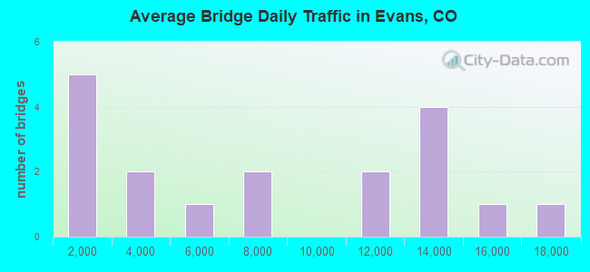
- 129,530Total average daily traffic
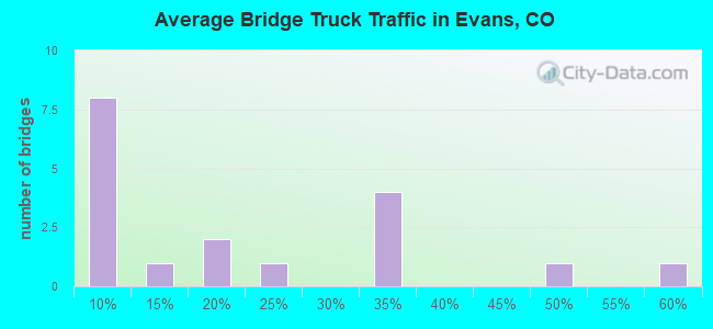
- 12,561Total average daily truck traffic
- National Bridge Inventory (NBI) Registered Bridges for Evans
- No street view available for this location
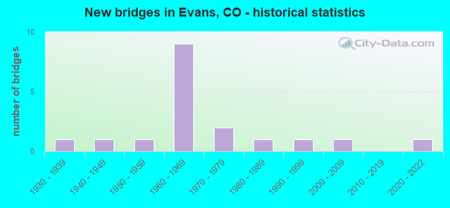
- New bridges - historical statistics
- 11930-1939
- 11940-1949
- 11950-1959
- 91960-1969
- 21970-1979
- 11980-1989
- 11990-1999
- 12000-2009
- 12020-2022
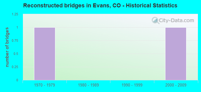
- Reconstructed bridges - Historical Statistics
- 11970-1979
- 01980-1989
- 01990-1999
- 12000-2009
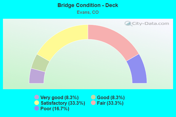
- Bridge Condition - Deck
- 8.3%Very good
- 8.3%Good
- 33.3%Satisfactory
- 33.3%Fair
- 16.7%Poor
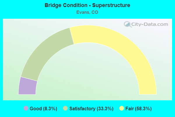
- Bridge Condition - Superstructure
- 8.3%Good
- 33.3%Satisfactory
- 58.3%Fair
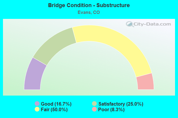
- Bridge Condition - Substructure
- 16.7%Good
- 25.0%Satisfactory
- 50.0%Fair
- 8.3%Poor
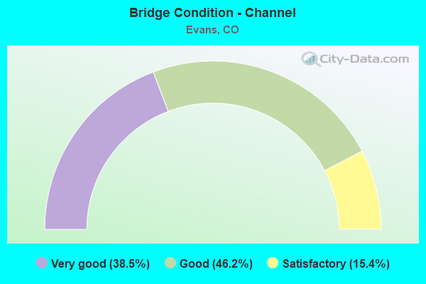
- Bridge Condition - Channel
- 38.5%Very good
- 46.2%Good
- 15.4%Satisfactory
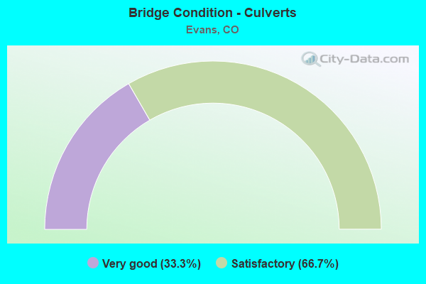
- Bridge Condition - Culverts
- 33.3%Very good
- 66.7%Satisfactory
Find on map >> Show street view
Structure Number: C-18-AD, Location: 9.1 MI E OF JCT SH 257 (Lat: 40.480939, Lng: -104.714142), Route carried "on" structure: State highway 392B, Year Built: 1969, Status: Open, Structure Length: 0.98m (3.22ft), Average Daily Traffic: 6,500 (year 2020), Truck Traffic: 15%, Average Future Daily Traffic: 10,075 (year 2040), Design Load: HS 20, Features Intersected: GREELEY CANAL NO 2, Facility Carried by Structure: SH 392 ML
Minimum Vertical Clearance: 30+ m (98+ ft), Kilometerpoint: 14.837, Lanes on structure: 2, Owner: State Highway Agency, Approaching Roadway Width: 7.9m (25.9ft), Skew: 3 degrees, Material/Design: Steel, Design/Construction: Stringer/Multi-beam, Number Of Spans In Main Unit: 1, Length of Maximum Span: 9.1m (29.9ft), Curb-To-Curb Width: 13.4m (44.0ft), Out-to-Out Width: 14.2m (46.6ft)
Condition: Deck: Good, Superstructure: Good, Substructure: Good, Channel: Very good, Operating Rating: 54.3 metric tons, Method Used To Determine Operating Rating: Load Factor (LF), Inventory Rating: 32.6 metric tons, Method Used To Determine Inventory Rating: Load Factor (LF), Structural Evaluation: Better than present minimum criteria, Deck Geometry: Equal to present minimum criteria, Waterway Adequacy: Equal to present desirable criteria, Approach Roadway Alignment: Equal to present desirable criteria, Designated Inspection Frequency: Every 24 months, Inspection Date: November 2021, Deck Structure Type: Concrete Cast-file-Place, Wearing Surface/Protective System: Wearing Surface: Bituminous, Membrane: Built-up
Find on map >> Show street view
Structure Number: C-18-AG, Location: S. EDGE OF EVANS (Lat: 40.363950, Lng: -104.696617), Route carried "on" structure: US 85C, Year Built: 1955, Status: Open, Structure Length: 29.02m (95.21ft), Average Daily Traffic: 12,500 (year 2020), Truck Traffic: 7%, Average Future Daily Traffic: 16,625 (year 2040), Design Load: HS 20, Features Intersected: SOUTH PLATTE RIVER, Facility Carried by Structure: US 85 ML SBND
Minimum Vertical Clearance: 30+ m (98+ ft), Kilometerpoint: 59.325, Lanes on structure: 2, Base Highway Network: Yes, Owner: State Highway Agency, Approaching Roadway Width: 11.6m (38.1ft), Skew: 10 degrees, Material/Design: Concrete, Design/Construction: Tee Beam, Number Of Spans In Main Unit: 19, Length of Maximum Span: 15.2m (49.9ft), Curb or Sidewalk Widths: Left: 0.8m (2.6ft), Right: 0.0m, Curb-To-Curb Width: 9.1m (29.9ft), Out-to-Out Width: 10.7m (35.1ft)
Condition: Deck: Satisfactory, Superstructure: Fair, Substructure: Poor, Channel: Satisfactory, Operating Rating: 49.1 metric tons, Method Used To Determine Operating Rating: Load Factor (LF), Inventory Rating: 29.5 metric tons, Method Used To Determine Inventory Rating: Load Factor (LF), Structural Evaluation: Meets minimum limits, Deck Geometry: Meets minimum limits, Waterway Adequacy: Better than present minimum criteria, Approach Roadway Alignment: Equal to present desirable criteria, Designated Inspection Frequency: Every 24 months, Inspection Date: November 2021, Deck Structure Type: Concrete Cast-file-Place, Wearing Surface/Protective System: Wearing Surface: Bituminous, Membrane: Built-up
Find on map >> Show street view
Structure Number: C-18-AP, Location: IN GREELEY (Lat: 40.391986, Lng: -104.687886), Route carried "on" structure: Business US 34A, Year Built: 1962, Status: Open, Structure Length: 7.09m (23.26ft), Average Daily Traffic: 16,500 (year 2020), Truck Traffic: 6%, Average Future Daily Traffic: 23,595 (year 2040), Design Load: HS 20, Features Intersected: US 85 BUSS RT, Facility Carried by Structure: WB 34 RMP TO SB 85
Minimum Vertical Clearance: 30+ m (98+ ft), Kilometerpoint: 180.565, Lanes on structure: 3, Lanes under structure: 5, Base Highway Network: Yes, Owner: State Highway Agency, Approaching Roadway Width: 13.4m (44.0ft), Skew: 3 degrees, Material/Design: Concrete continuous, Design/Construction: Tee Beam, Number Of Spans In Main Unit: 4, Length of Maximum Span: 19.8m (65.0ft), Curb-To-Curb Width: 12.2m (40.0ft), Out-to-Out Width: 13.4m (44.0ft)
Condition: Deck: Poor, Superstructure: Fair, Substructure: Fair, Operating Rating: 58.1 metric tons, Method Used To Determine Operating Rating: Load Factor (LF), Inventory Rating: 34.7 metric tons, Method Used To Determine Inventory Rating: Load Factor (LF), Structural Evaluation: Somewhat better than minimum adequacy, Deck Geometry: High priority of corrective action, Underclear: Somewhat better than minimum adequacy, Approach Roadway Alignment: Equal to present desirable criteria, Length Of Structure Improvement: 7.10m (23.29ft), Designated Inspection Frequency: Every 24 months, Inspection Date: August 2021, Bridge Improvement Cost: $369,000, Roadway Improvement Cost: $37,000, Total Project Cost: $554,000, Deck Structure Type: Other, Wearing Surface/Protective System: Wearing Surface: Bituminous, Membrane: Preformed Fabric
Find on map >> Show street view
Structure Number: C-18-AV, Location: IN GREELEY (Lat: 40.390564, Lng: -104.690706), Route carried "on" structure: US 34A, Year Built: 1968, Status: Open, Structure Length: 6.86m (22.51ft), Average Daily Traffic: 15,000 (year 2020), Truck Traffic: 5%, Average Future Daily Traffic: 21,300 (year 2040), Design Load: HS 20+Mod, Features Intersected: RAMP TO US 85 SBND, Facility Carried by Structure: US 34 ML EBND
Minimum Vertical Clearance: 30+ m (98+ ft), Kilometerpoint: 180.266, Lanes on structure: 2, Lanes under structure: 5, Base Highway Network: Yes, Owner: State Highway Agency, Approaching Roadway Width: 11.6m (38.1ft), Material/Design: Steel continuous, Design/Construction: Stringer/Multi-beam, Number Of Spans In Main Unit: 3, Length of Maximum Span: 28.0m (91.9ft), Curb-To-Curb Width: 11.6m (38.1ft), Out-to-Out Width: 12.3m (40.4ft)
Condition: Deck: Poor, Superstructure: Fair, Substructure: Fair, Operating Rating: 46.4 metric tons, Method Used To Determine Operating Rating: Load Factor (LF), Inventory Rating: 27.9 metric tons, Method Used To Determine Inventory Rating: Load Factor (LF), Structural Evaluation: Somewhat better than minimum adequacy, Deck Geometry: Equal to present minimum criteria, Underclear: Superior to present desirable criteria, Approach Roadway Alignment: Equal to present desirable criteria, Length Of Structure Improvement: 6.86m (22.51ft), Designated Inspection Frequency: Every 24 months, Inspection Date: August 2021, Bridge Improvement Cost: $800,000, Roadway Improvement Cost: $80,000, Total Project Cost: $1,200,000 ( Estimate for 2019), Deck Structure Type: Concrete Cast-file-Place, Wearing Surface/Protective System: Wearing Surface: Bituminous, Membrane: Built-up
Find on map >> Show street view
Structure Number: C-18-FC, Location: JUST SO OF EVANS (Lat: 40.363017, Lng: -104.696625), Route carried "on" structure: US 85C, Year Built: 2008, Status: Open, Structure Length: 1.29m (4.23ft), Average Daily Traffic: 12,500 (year 2020), Truck Traffic: 7%, Average Future Daily Traffic: 16,625 (year 2040), Design Load: H 20, Features Intersected: LATHAM CANAL, Facility Carried by Structure: US 85 ML SBND
Minimum Vertical Clearance: 30+ m (98+ ft), Kilometerpoint: 59.221, Lanes on structure: 4, Base Highway Network: Yes, Owner: State Highway Agency, Approaching Roadway Width: 23.2m (76.1ft), Skew: 1 degrees, Material/Design: Concrete, Design/Construction: Culvert, Number Of Spans In Main Unit: 2, Length of Maximum Span: 6.3m (20.7ft), Out-to-Out Width: 45.2m (148.3ft)
Condition: Channel: Good, Culverts: Satisfactory, Operating Rating: 36.3 metric tons, Method Used To Determine Operating Rating: Field evaluation and documented engineering judgment, Inventory Rating: 32.7 metric tons, Method Used To Determine Inventory Rating: Field evaluation and documented engineering judgment, Structural Evaluation: Equal to present minimum criteria, Waterway Adequacy: Equal to present desirable criteria, Approach Roadway Alignment: Equal to present desirable criteria, Designated Inspection Frequency: Every 24 months, Inspection Date: November 2021
Find on map >> Show street view
Structure Number: C-18-K, Location: EVANS (Lat: 40.363947, Lng: -104.696461), Route carried "on" structure: US 85C, Year Built: 1936, Year Reconstructed: 1970, Status: Open, Structure Length: 29.02m (95.21ft), Average Daily Traffic: 12,500 (year 2020), Truck Traffic: 7%, Average Future Daily Traffic: 16,625 (year 2040), Design Load: HS 20, Features Intersected: SOUTH PLATTE RIVER, Facility Carried by Structure: US 85 ML NBND
Minimum Vertical Clearance: 30+ m (98+ ft), Kilometerpoint: 59.325, Lanes on structure: 2, Base Highway Network: Yes, Owner: State Highway Agency, Approaching Roadway Width: 9.8m (32.2ft), Skew: 10 degrees, Material/Design: Steel continuous, Design/Construction: Stringer/Multi-beam, Number Of Spans In Main Unit: 19, Length of Maximum Span: 15.2m (49.9ft), Curb-To-Curb Width: 10.2m (33.5ft), Out-to-Out Width: 11.0m (36.1ft)
Condition: Deck: Fair, Superstructure: Satisfactory, Substructure: Satisfactory, Channel: Good, Operating Rating: 46.3 metric tons, Method Used To Determine Operating Rating: Load Factor (LF), Inventory Rating: 27.2 metric tons, Method Used To Determine Inventory Rating: Load Factor (LF), Structural Evaluation: Equal to present minimum criteria, Deck Geometry: Meets minimum limits, Waterway Adequacy: Equal to present minimum criteria, Approach Roadway Alignment: Equal to present desirable criteria, Designated Inspection Frequency: Every 24 months, Inspection Date: November 2021, Deck Structure Type: Concrete Cast-file-Place, Wearing Surface/Protective System: Wearing Surface: Bituminous
Find on map >> Show street view
Structure Number: EVN031.0-050.0A, Location: 0.2 Mi So of 54 ST RD (Lat: 40.351306, Lng: -104.775000), Route carried "on" structure: City street , Year Built: 1965, Status: Open, Structure Length: 3.73m (12.24ft), Average Daily Traffic: 136 (year 2021), Truck Traffic: 33%, Average Future Daily Traffic: 193 (year 2041), Design Load: HS 20, Features Intersected: Big Thompson River, Facility Carried by Structure: County Road 396
Minimum Vertical Clearance: 30+ m (98+ ft), Kilometerpoint: 1.540, Lanes on structure: 2, Owner: City or Municipal Highway Agency, Approaching Roadway Width: 7.3m (24.0ft), Material/Design: Prestressed concrete, Design/Construction: Tee Beam, Number Of Spans In Main Unit: 3, Length of Maximum Span: 11.9m (39.0ft), Curb-To-Curb Width: 8.4m (27.6ft), Out-to-Out Width: 8.5m (27.9ft)
Condition: Deck: Fair, Superstructure: Fair, Substructure: Fair, Channel: Good, Operating Rating: 36.3 metric tons, Method Used To Determine Operating Rating: Field evaluation and documented engineering judgment, Inventory Rating: 32.7 metric tons, Method Used To Determine Inventory Rating: Field evaluation and documented engineering judgment, Structural Evaluation: Somewhat better than minimum adequacy, Deck Geometry: Somewhat better than minimum adequacy, Waterway Adequacy: Equal to present desirable criteria, Approach Roadway Alignment: Equal to present desirable criteria, Length Of Structure Improvement: 4.66m (15.29ft), Designated Inspection Frequency: Every 24 months, Inspection Date: April 2020, Deck Structure Type: Other, Wearing Surface/Protective System: Wearing Surface: Monolithic Concrete
Find on map >> Show street view
Structure Number: EVN033.0-048.0A, Location: 50 Ft So of Co Rd 394 (Lat: 40.340111, Lng: -104.754111), Route carried "on" structure: City street , Year Built: 1940, Status: Open, Structure Length: 0.70m (2.30ft), Average Daily Traffic: 223 (year 2021), Truck Traffic: 32%, Average Future Daily Traffic: 317 (year 2041), Design Load: HS 20, Features Intersected: Union Ditch, Facility Carried by Structure: County Road 33
Minimum Vertical Clearance: 30+ m (98+ ft), Kilometerpoint: 13.509, Lanes on structure: 2, Owner: City or Municipal Highway Agency, Approaching Roadway Width: 6.1m (20.0ft), Material/Design: Concrete, Design/Construction: Slab, Number Of Spans In Main Unit: 1, Length of Maximum Span: 6.1m (20.0ft), Curb-To-Curb Width: 5.4m (17.7ft), Out-to-Out Width: 6.2m (20.3ft)
Condition: Deck: Satisfactory, Superstructure: Satisfactory, Substructure: Good, Channel: Good, Operating Rating: 36.3 metric tons, Method Used To Determine Operating Rating: Field evaluation and documented engineering judgment, Inventory Rating: 32.7 metric tons, Method Used To Determine Inventory Rating: Field evaluation and documented engineering judgment, Structural Evaluation: Equal to present minimum criteria, Deck Geometry: High priority of replacement, Waterway Adequacy: Equal to present desirable criteria, Approach Roadway Alignment: Equal to present desirable criteria, Length Of Structure Improvement: 0.70m (2.30ft), Designated Inspection Frequency: Every 24 months, Inspection Date: March 2022, Bridge Improvement Cost: $89,000, Roadway Improvement Cost: $9,000, Total Project Cost: $98,000 ( Estimate for 2018), Deck Structure Type: Concrete Cast-file-Place, Wearing Surface/Protective System: Wearing Surface: Monolithic Concrete
Find on map >> Show street view
Structure Number: EVN052.0-033.0A, Location: 0.9 Mi E of 47th Ave (Lat: 40.363583, Lng: -104.738528), Route carried "on" structure: City street , Year Built: 1965, Status: Open, Structure Length: 1.24m (4.07ft), Average Daily Traffic: 7,772 (year 2021), Truck Traffic: 17%, Average Future Daily Traffic: 11,036 (year 2041), Design Load: HS 20, Features Intersected: Ashcroft Draw, Facility Carried by Structure: 49th Street (CR52)
Minimum Vertical Clearance: 30+ m (98+ ft), Kilometerpoint: 2.639, Lanes on structure: 2, Owner: City or Municipal Highway Agency, Approaching Roadway Width: 7.3m (24.0ft), Material/Design: Prestressed concrete, Design/Construction: Tee Beam, Number Of Spans In Main Unit: 1, Length of Maximum Span: 11.9m (39.0ft), Curb-To-Curb Width: 8.4m (27.6ft), Out-to-Out Width: 8.6m (28.2ft)
Condition: Deck: Satisfactory, Superstructure: Satisfactory, Substructure: Fair, Channel: Good, Operating Rating: 36.3 metric tons, Method Used To Determine Operating Rating: Field evaluation and documented engineering judgment, Inventory Rating: 32.7 metric tons, Method Used To Determine Inventory Rating: Field evaluation and documented engineering judgment, Structural Evaluation: Somewhat better than minimum adequacy, Deck Geometry: High priority of replacement, Waterway Adequacy: Equal to present desirable criteria, Approach Roadway Alignment: Equal to present desirable criteria, Length Of Structure Improvement: 1.25m (4.10ft), Designated Inspection Frequency: Every 24 months, Inspection Date: April 2020, Bridge Improvement Cost: $202,000, Roadway Improvement Cost: $20,000, Total Project Cost: $223,000 ( Estimate for 2018), Deck Structure Type: Other, Wearing Surface/Protective System: Wearing Surface: Bituminous
Find on map >> Show street view
Structure Number: EVN054.0-031.0A, Location: 0.5 Mi E of Co Rd 29.5 (Lat: 40.377861, Lng: -104.766028), Route carried "on" structure: City street , Year Built: 1992, Status: Open, Structure Length: 0.71m (2.33ft), Average Daily Traffic: 12,903 (year 2021), Truck Traffic: 13%, Average Future Daily Traffic: 18,322 (year 2041), Design Load: HS 20, Features Intersected: Ashcroft Draw, Facility Carried by Structure: CR54 (37th St)
Minimum Vertical Clearance: 30+ m (98+ ft), Kilometerpoint: 2.377, Lanes on structure: 2, Owner: City or Municipal Highway Agency, Approaching Roadway Width: 7.9m (25.9ft), Skew: 2 degrees, Material/Design: Steel, Design/Construction: Stringer/Multi-beam, Number Of Spans In Main Unit: 1, Length of Maximum Span: 6.5m (21.3ft), Curb-To-Curb Width: 10.1m (33.1ft), Out-to-Out Width: 10.2m (33.5ft)
Condition: Deck: Very good, Superstructure: Fair, Substructure: Fair, Channel: Satisfactory, Operating Rating: 40.3 metric tons, Method Used To Determine Operating Rating: Load Factor (LF), Inventory Rating: 24.1 metric tons, Method Used To Determine Inventory Rating: Load Factor (LF), Structural Evaluation: Somewhat better than minimum adequacy, Deck Geometry: Meets minimum limits, Waterway Adequacy: Equal to present desirable criteria, Approach Roadway Alignment: Equal to present desirable criteria, Designated Inspection Frequency: Every 24 months, Inspection Date: April 2020, Deck Structure Type: Corrugated Steel, Wearing Surface/Protective System: Wearing Surface: Bituminous
Find on map >> Show street view
Structure Number: WEL027.0-052.1A, Location: 0.2 Mi N of 49th St. (Lat: 40.366472, Lng: -104.812861), Route carried "on" structure: County highway , Year Built: 1983, Status: Open, Structure Length: 0.92m (3.02ft), Average Daily Traffic: 64 (year 2021), Truck Traffic: 33%, Average Future Daily Traffic: 91 (year 2041), Design Load: HS 20, Features Intersected: Loveland and Greeley Can, Facility Carried by Structure: CR27 (83rd Ave)
Minimum Vertical Clearance: 30+ m (98+ ft), Kilometerpoint: 0.370, Lanes on structure: 2, Owner: County Highway Agency, Approaching Roadway Width: 7.0m (23.0ft), Skew: 2 degrees, Material/Design: Steel, Design/Construction: Stringer/Multi-beam, Number Of Spans In Main Unit: 1, Length of Maximum Span: 8.1m (26.6ft), Curb-To-Curb Width: 9.7m (31.8ft), Out-to-Out Width: 9.8m (32.2ft)
Condition: Deck: Fair, Superstructure: Fair, Substructure: Satisfactory, Channel: Very good, Operating Rating: 36.5 metric tons, Method Used To Determine Operating Rating: Load Factor (LF), Inventory Rating: 21.9 metric tons, Method Used To Determine Inventory Rating: Load Factor (LF), Structural Evaluation: Somewhat better than minimum adequacy, Deck Geometry: Better than present minimum criteria, Waterway Adequacy: Equal to present desirable criteria, Approach Roadway Alignment: Equal to present desirable criteria, Designated Inspection Frequency: Every 24 months, Inspection Date: April 2020, Deck Structure Type: Corrugated Steel, Wearing Surface/Protective System: Wearing Surface: Gravel
Find on map >> Show street view
Structure Number: WEL033.0-052.2A, Location: Arrowhead Dr & 37th S (Lat: 40.373806, Lng: -104.757806), Route carried "on" structure: County highway , Year Built: 1970, Status: Open, Structure Length: 1.16m (3.81ft), Average Daily Traffic: 842 (year 2021), Truck Traffic: 22%, Average Future Daily Traffic: 1,196 (year 2041), Features Intersected: Ashcroft Draw, Facility Carried by Structure: County Road 33
Minimum Vertical Clearance: 30+ m (98+ ft), Kilometerpoint: 1.418, Lanes on structure: 2, Owner: County Highway Agency, Approaching Roadway Width: 7.6m (24.9ft), Material/Design: Concrete, Design/Construction: Culvert, Number Of Spans In Main Unit: 4, Length of Maximum Span: 2.7m (8.9ft), Out-to-Out Width: 12.2m (40.0ft)
Condition: Channel: Very good, Culverts: Satisfactory, Operating Rating: 36.3 metric tons, Method Used To Determine Operating Rating: Field evaluation and documented engineering judgment, Inventory Rating: 32.7 metric tons, Method Used To Determine Inventory Rating: Field evaluation and documented engineering judgment, Structural Evaluation: Equal to present minimum criteria, Waterway Adequacy: Equal to present desirable criteria, Approach Roadway Alignment: Equal to present desirable criteria, Designated Inspection Frequency: Every 24 months, Inspection Date: April 2020
Find on map >> Show street view
Structure Number: WEL035.0-048.0A, Location: 0.5 Mi N of Co Rd 48 (Lat: 40.340639, Lng: -104.735000), Route carried "on" structure: County highway , Year Built: 1960, Year Reconstructed: 2007, Status: Open, Structure Length: 0.87m (2.85ft), Average Daily Traffic: 539 (year 2021), Truck Traffic: 47%, Average Future Daily Traffic: 765 (year 2041), Design Load: HS 20, Features Intersected: Union Ditch, Facility Carried by Structure: County Road 35
Minimum Vertical Clearance: 30+ m (98+ ft), Kilometerpoint: 13.696, Lanes on structure: 2, Owner: County Highway Agency, Approaching Roadway Width: 7.3m (24.0ft), Skew: 1 degrees, Material/Design: Steel, Design/Construction: Stringer/Multi-beam, Number Of Spans In Main Unit: 1, Length of Maximum Span: 7.9m (25.9ft), Curb-To-Curb Width: 9.5m (31.2ft), Out-to-Out Width: 9.7m (31.8ft)
Condition: Deck: Fair, Superstructure: Satisfactory, Substructure: Satisfactory, Channel: Very good, Operating Rating: 44.8 metric tons, Method Used To Determine Operating Rating: Load Factor (LF), Inventory Rating: 26.9 metric tons, Method Used To Determine Inventory Rating: Load Factor (LF), Structural Evaluation: Equal to present minimum criteria, Deck Geometry: Equal to present minimum criteria, Waterway Adequacy: Equal to present desirable criteria, Approach Roadway Alignment: Better than present minimum criteria, Designated Inspection Frequency: Every 24 months, Inspection Date: April 2020, Deck Structure Type: Corrugated Steel, Wearing Surface/Protective System: Wearing Surface: Bituminous
Find on map >> Show street view
Structure Number: WEL044.0_033.0A, Location: 0.7 Mi E of US Hwy 85 (Lat: 40.304667, Lng: -104.738111), Route carried "on" structure: County highway , Year Built: 2020, Status: Open, Structure Length: 0.73m (2.40ft), Average Daily Traffic: 2,146 (year 2021), Truck Traffic: 59%, Average Future Daily Traffic: 3,047 (year 2041), Design Load: HL 93, Features Intersected: Western Mutual Ditch, Facility Carried by Structure: County Road 44
Minimum Vertical Clearance: 30+ m (98+ ft), Kilometerpoint: 6.151, Lanes on structure: 2, Owner: County Highway Agency, Approaching Roadway Width: 8.6m (28.2ft), Skew: 4 degrees, Material/Design: Concrete, Design/Construction: Culvert, Number Of Spans In Main Unit: 1, Length of Maximum Span: 7.3m (24.0ft), Curb-To-Curb Width: 8.6m (28.2ft), Out-to-Out Width: 15.9m (52.2ft)
Condition: Channel: Very good, Culverts: Very good, Operating Rating: 61.2 metric tons, Method Used To Determine Operating Rating: Load and Resistance Factor Rating (LRFR) rating reported by rating factor(RF) method using HL-93 loadings, Inventory Rating: 47.0 metric tons, Method Used To Determine Inventory Rating: Load and Resistance Factor Rating (LRFR) rating reported by rating factor(RF) method using HL-93 loadings, Structural Evaluation: Equal to present desirable criteria, Deck Geometry: Meets minimum limits, Waterway Adequacy: Equal to present desirable criteria, Approach Roadway Alignment: Equal to present desirable criteria, Designated Inspection Frequency: Every 24 months, Inspection Date: April 2020
Find on map >> Show street view
Structure Number: WEL054.0-041.0A, Location: 0.1 Mi E of Co Rd 41 (Lat: 40.377500, Lng: -104.675056), Route carried "on" structure: County highway , Year Built: 1973, Status: Open, Structure Length: 16.46m (54.00ft), Average Daily Traffic: 3,005 (year 2021), Truck Traffic: 31%, Average Future Daily Traffic: 4,267 (year 2041), Design Load: HS 20, Features Intersected: South Platte River, Facility Carried by Structure: County Road 54
Minimum Vertical Clearance: 30+ m (98+ ft), Kilometerpoint: 0.225, Lanes on structure: 2, Owner: County Highway Agency, Approaching Roadway Width: 7.6m (24.9ft), Material/Design: Prestressed concrete, Design/Construction: Tee Beam, Number Of Spans In Main Unit: 11, Length of Maximum Span: 14.6m (47.9ft), Curb-To-Curb Width: 9.6m (31.5ft), Out-to-Out Width: 9.8m (32.2ft)
Condition: Deck: Satisfactory, Superstructure: Fair, Substructure: Fair, Channel: Good, Operating Rating: 36.3 metric tons, Method Used To Determine Operating Rating: Field evaluation and documented engineering judgment, Inventory Rating: 32.7 metric tons, Method Used To Determine Inventory Rating: Field evaluation and documented engineering judgment, Structural Evaluation: Somewhat better than minimum adequacy, Deck Geometry: Meets minimum limits, Waterway Adequacy: Better than present minimum criteria, Approach Roadway Alignment: Equal to present desirable criteria, Designated Inspection Frequency: Every 24 months, Inspection Date: June 2020, Deck Structure Type: Concrete Cast-file-Place, Wearing Surface/Protective System: Wearing Surface: Bituminous, Membrane: Preformed Fabric
Find on map >> Show street view
Structure Number: C-18-AP, Location: IN GREELEY (Lat: 40.391986, Lng: -104.687886), Route carried "under" structure: Business US 85G, Year Built: 1962, Structure Length: 0. m, Average Daily Traffic: 11,000 (year 2011), Truck Traffic: 5%, Features Intersected: US 85 BUSS RT, Facility Carried by Structure: WB 34 RMP TO SB 85
Minimum Vertical Clearance: 5.89m (19.32ft), Kilometerpoint: 0.579, Lanes on structure: 3, Lanes under structure: 4, Material/Design: Concrete continuous, Design/Construction: Tee Beam, Length of Maximum Span: 19.8m (65.0ft)
Find on map >> Show street view
Structure Number: C-18-AV, Location: IN GREELEY (Lat: 40.390564, Lng: -104.690706), Route carried "under" structure: Ramp US 85C, Year Built: 1968, Structure Length: 0. m, Average Daily Traffic: 4,400 (year 2005), Truck Traffic: 8%, Features Intersected: RAMP TO US 85 SBND, Facility Carried by Structure: US 34 ML EBND
Minimum Vertical Clearance: 5.62m (18.44ft), Kilometerpoint: 427.302, Lanes on structure: 2, Lanes under structure: 5, Material/Design: Steel continuous, Design/Construction: Stringer/Multi-beam, Length of Maximum Span: 28.0m (91.9ft)
Find on map >> Show street view
Structure Number: C-18-BB, Location: S. SIDE OF GREELEY (Lat: 40.390158, Lng: -104.688667), Route carried "under" structure: Bypass US 85G, Year Built: 1968, Structure Length: 0. m, Average Daily Traffic: 11,000 (year 2011), Truck Traffic: 5%, Features Intersected: US 85 BUSS RT, Facility Carried by Structure: US 34 BYPASS
Minimum Vertical Clearance: 5.31m (17.42ft), Kilometerpoint: 0.370, Lanes on structure: 3, Lanes under structure: 6, Material/Design: Steel continuous, Design/Construction: Stringer/Multi-beam, Length of Maximum Span: 30.5m (100.1ft)