Bridge Statistics for Fairburn, Georgia (GA)
Condition, Traffic, Stress, Structural Evaluation, Project Costs
- National Bridge Inventory (NBI) Statistics
- 35Number of bridges
- 338ft / 103mTotal length
- $31,733,000Total costs
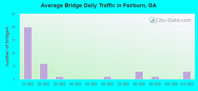
- 817,312Total average daily traffic
- 8,912Total average daily truck traffic
- National Bridge Inventory (NBI) Registered Bridges for Fairburn
- No street view available for this location
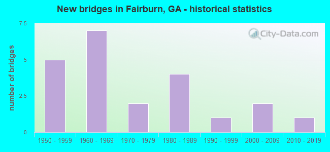
- New bridges - historical statistics
- 51950-1959
- 71960-1969
- 21970-1979
- 41980-1989
- 11990-1999
- 22000-2009
- 12010-2019
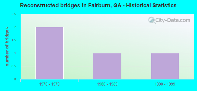
- Reconstructed bridges - Historical Statistics
- 21970-1979
- 11980-1989
- 11990-1999
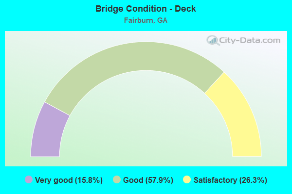
- Bridge Condition - Deck
- 15.8%Very good
- 57.9%Good
- 26.3%Satisfactory
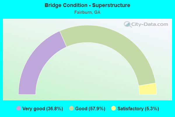
- Bridge Condition - Superstructure
- 36.8%Very good
- 57.9%Good
- 5.3%Satisfactory
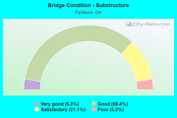
- Bridge Condition - Substructure
- 5.3%Very good
- 68.4%Good
- 21.1%Satisfactory
- 5.3%Poor
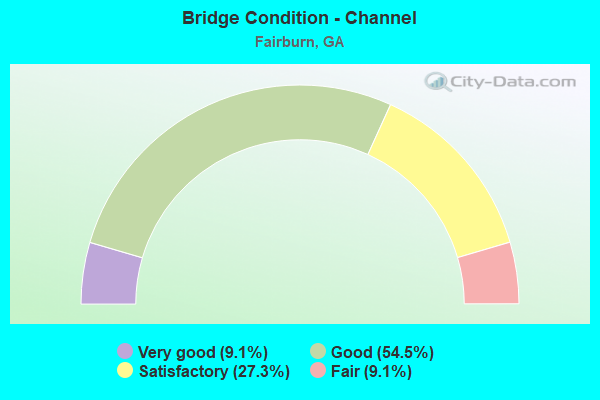
- Bridge Condition - Channel
- 9.1%Very good
- 54.5%Good
- 27.3%Satisfactory
- 9.1%Fair
Find on map >> Show street view
Structure Number: 770064, Location: 3 MI SE OF PALMETTO (Lat: 33.494908, Lng: -84.622039), Route carried "on" structure: County highway 846, Year Built: 1987, Status: Open, Structure Length: 0.88m (2.89ft), Average Daily Traffic: 6,490 (year 2012), Truck Traffic: 1%, Average Future Daily Traffic: 9,735 (year 2032), Design Load: HS 20+Mod, Features Intersected: PEEKS CREEK, Facility Carried by Structure: COLLINSWORTH ROAD
Minimum Vertical Clearance: 30+ m (98+ ft), Kilometerpoint: 3.219, Lanes on structure: 2, Base Highway Network: Yes, Owner: County Highway Agency, Approaching Roadway Width: 7.3m (24.0ft), Material/Design: Concrete, Design/Construction: Culvert, Number Of Spans In Main Unit: 3, Length of Maximum Span: 2.7m (8.9ft)
Condition: Channel: Satisfactory, Culverts: Good, Operating Rating: 55.3 metric tons, Method Used To Determine Operating Rating: Field evaluation and documented engineering judgment, Inventory Rating: 32.6 metric tons, Method Used To Determine Inventory Rating: Field evaluation and documented engineering judgment, Structural Evaluation: Better than present minimum criteria, Waterway Adequacy: Equal to present desirable criteria, Approach Roadway Alignment: Equal to present desirable criteria, Designated Inspection Frequency: Every 24 months, Inspection Date: November 2020, Bridge Improvement Cost: $113,000, Roadway Improvement Cost: $11,000, Total Project Cost: $170,000
Find on map >> Show street view
Structure Number: 1135004, Location: 3 MI NE OF TYRONE (Lat: 33.527119, Lng: -84.556628), Route carried "on" structure: County highway 59, Year Built: 1960, Status: Open, Structure Length: 1.01m (3.31ft), Average Daily Traffic: 2,202 (year 2011), Truck Traffic: 1%, Average Future Daily Traffic: 3,303 (year 2031), Design Load: H 15, Features Intersected: WHITEWATER CREEK, Facility Carried by Structure: MILAM ROAD
Minimum Vertical Clearance: 30+ m (98+ ft), Kilometerpoint: 4.828, Lanes on structure: 2, Base Highway Network: Yes, Owner: County Highway Agency, Approaching Roadway Width: 7.3m (24.0ft), Skew: 1 degrees, Material/Design: Concrete, Design/Construction: Culvert, Number Of Spans In Main Unit: 3, Length of Maximum Span: 3.0m (9.8ft)
Condition: Channel: Good, Culverts: Good, Operating Rating: 41.7 metric tons, Method Used To Determine Operating Rating: Field evaluation and documented engineering judgment, Inventory Rating: 24.4 metric tons, Method Used To Determine Inventory Rating: Field evaluation and documented engineering judgment, Structural Evaluation: Equal to present minimum criteria, Waterway Adequacy: Better than present minimum criteria, Approach Roadway Alignment: Equal to present desirable criteria, Designated Inspection Frequency: Every 24 months, Underwater Inspection Frequency: Every 60 months, Inspection Date: May 2020, Underwater Inspection Date: April 2019, Bridge Improvement Cost: $129,000, Roadway Improvement Cost: $13,000, Total Project Cost: $193,000
Find on map >> Show street view
Structure Number: 1210041, Location: IN THE CITY OF FAIRBURN (Lat: 33.557400, Lng: -84.591989), Route carried "on" structure: US 29, Year Built: 1981, Status: Open, Structure Length: 4.45m (14.60ft), Average Daily Traffic: 10,010 (year 2011), Truck Traffic: 8%, Average Future Daily Traffic: 15,015 (year 2031), Design Load: HS 20+Mod, Features Intersected: SR 74
Minimum Vertical Clearance: 30+ m (98+ ft), Kilometerpoint: 9.656, Lanes on structure: 4, Lanes under structure: 4, Base Highway Network: Yes, Owner: State Highway Agency, Approaching Roadway Width: 15.8m (51.8ft), Material/Design: Steel continuous, Design/Construction: Stringer/Multi-beam, Number Of Spans In Main Unit: 3, Length of Maximum Span: 22.9m (75.1ft), Curb or Sidewalk Widths: Left: 1.5m (4.9ft), Right: 0.0m, Curb-To-Curb Width: 15.8m (51.8ft), Out-to-Out Width: 18.1m (59.4ft)
Condition: Deck: Satisfactory, Superstructure: Good, Substructure: Good, Operating Rating: 46.2 metric tons, Method Used To Determine Operating Rating: Allowable Stress (AS), Inventory Rating: 32.6 metric tons, Method Used To Determine Inventory Rating: Allowable Stress (AS), Structural Evaluation: Better than present minimum criteria, Deck Geometry: Meets minimum limits, Underclear: Meets minimum limits, Approach Roadway Alignment: Equal to present desirable criteria, Designated Inspection Frequency: Every 24 months, Inspection Date: November 2020, Bridge Improvement Cost: $882,000, Roadway Improvement Cost: $88,000, Total Project Cost: $1,322,000, Deck Structure Type: Concrete Cast-file-Place
Find on map >> Show street view
Structure Number: 1210069, Location: 1.5 M S OF FAIRBURN (Lat: 33.546003, Lng: -84.577561), Route carried "on" structure: State highway 74, Year Built: 1965, Year Reconstructed: 1987, Status: Open, Structure Length: 8.47m (27.79ft), Average Daily Traffic: 19,920 (year 2012), Truck Traffic: 1%, Average Future Daily Traffic: 29,880 (year 2032), Design Load: HS 20+Mod, Features Intersected: I-85
Minimum Vertical Clearance: 30+ m (98+ ft), Kilometerpoint: 3.219, Lanes on structure: 2, Lanes under structure: 6, Base Highway Network: Yes, Owner: State Highway Agency, Approaching Roadway Width: 13.4m (44.0ft), Skew: 11 degrees, Material/Design: Steel, Design/Construction: Stringer/Multi-beam, Number Of Spans In Main Unit: 4, Length of Maximum Span: 23.2m (76.1ft), Curb-To-Curb Width: 11.6m (38.1ft), Out-to-Out Width: 12.6m (41.3ft)
Condition: Deck: Satisfactory, Superstructure: Good, Substructure: Good, Operating Rating: 36.2 metric tons, Method Used To Determine Operating Rating: Load Factor (LF), Inventory Rating: 21.7 metric tons, Method Used To Determine Inventory Rating: Load Factor (LF), Structural Evaluation: Somewhat better than minimum adequacy, Deck Geometry: Better than present minimum criteria, Underclear: Meets minimum limits, Approach Roadway Alignment: Better than present minimum criteria, Designated Inspection Frequency: Every 24 months, Inspection Date: November 2020, Bridge Improvement Cost: $1,086,000, Roadway Improvement Cost: $109,000, Total Project Cost: $1,629,000, Deck Structure Type: Concrete Cast-file-Place
Find on map >> Show street view
Structure Number: 1210071, Location: 1.3 S OF FAIRBURN (Lat: 33.549831, Lng: -84.568703), Route carried "on" structure: State highway 92, Year Built: 1965, Status: Open, Structure Length: 8.17m (26.80ft), Average Daily Traffic: 5,490 (year 2012), Truck Traffic: 1%, Average Future Daily Traffic: 8,235 (year 2032), Design Load: HS 20+Mod, Features Intersected: I-85, Facility Carried by Structure: SPENCE ROAD
Minimum Vertical Clearance: 30+ m (98+ ft), Kilometerpoint: 4.828, Lanes on structure: 2, Lanes under structure: 8, Base Highway Network: Yes, Owner: State Highway Agency, Approaching Roadway Width: 7.9m (25.9ft), Material/Design: Steel, Design/Construction: Stringer/Multi-beam, Number Of Spans In Main Unit: 4, Length of Maximum Span: 21.6m (70.9ft), Curb or Sidewalk Widths: Left: 0.6m (2.0ft), Right: 0.6m (2.0ft), Curb-To-Curb Width: 8.5m (27.9ft), Out-to-Out Width: 10.4m (34.1ft)
Condition: Deck: Satisfactory, Superstructure: Good, Substructure: Good, Operating Rating: 39.0 metric tons, Method Used To Determine Operating Rating: Load Factor (LF), Inventory Rating: 23.5 metric tons, Method Used To Determine Inventory Rating: Load Factor (LF), Structural Evaluation: Somewhat better than minimum adequacy, Deck Geometry: Meets minimum limits, Underclear: High priority of corrective action, Approach Roadway Alignment: Better than present minimum criteria, Designated Inspection Frequency: Every 24 months, Inspection Date: May 2020, Bridge Improvement Cost: $1,047,000, Roadway Improvement Cost: $105,000, Total Project Cost: $1,571,000, Deck Structure Type: Concrete Cast-file-Place
Find on map >> Show street view
Structure Number: 1210263, Location: 2 MILES SW OF FAIRBURN (Lat: 33.539128, Lng: -84.591489), Route carried "on" structure: County highway 627, Year Built: 1965, Status: Open, Structure Length: 8.53m (27.99ft), Average Daily Traffic: 490 (year 2012), Truck Traffic: 1%, Average Future Daily Traffic: 735 (year 2032), Design Load: HS 20+Mod, Features Intersected: I-85, Facility Carried by Structure: BOHANNON ROAD
Minimum Vertical Clearance: 30+ m (98+ ft), Kilometerpoint: 1.609, Lanes on structure: 2, Lanes under structure: 8, Base Highway Network: Yes, Owner: State Highway Agency, Approaching Roadway Width: 7.0m (23.0ft), Skew: 1 degrees, Material/Design: Steel, Design/Construction: Stringer/Multi-beam, Number Of Spans In Main Unit: 4, Length of Maximum Span: 22.9m (75.1ft), Curb or Sidewalk Widths: Left: 0.6m (2.0ft), Right: 0.6m (2.0ft), Curb-To-Curb Width: 8.5m (27.9ft), Out-to-Out Width: 10.4m (34.1ft)
Condition: Deck: Good, Superstructure: Very good, Substructure: Good, Operating Rating: 46.2 metric tons, Method Used To Determine Operating Rating: Allowable Stress (AS), Inventory Rating: 32.6 metric tons, Method Used To Determine Inventory Rating: Allowable Stress (AS), Structural Evaluation: Better than present minimum criteria, Deck Geometry: Somewhat better than minimum adequacy, Underclear: Equal to present minimum criteria, Approach Roadway Alignment: Equal to present desirable criteria, Designated Inspection Frequency: Every 24 months, Inspection Date: November 2020, Bridge Improvement Cost: $1,094,000, Roadway Improvement Cost: $109,000, Total Project Cost: $1,641,000, Deck Structure Type: Concrete Cast-file-Place
Find on map >> Show street view
Structure Number: 1210264, Location: IN FAIRBURN (Lat: 33.557161, Lng: -84.591606), Route carried "on" structure: County highway 633, Year Built: 1981, Status: Open, Structure Length: 4.69m (15.39ft), Average Daily Traffic: 1,940 (year 2011), Truck Traffic: 1%, Average Future Daily Traffic: 2,910 (year 2031), Design Load: HS 20+Mod, Features Intersected: SR 74, Facility Carried by Structure: BOHANNON ROAD
Minimum Vertical Clearance: 30+ m (98+ ft), Kilometerpoint: 3.219, Lanes on structure: 2, Lanes under structure: 4, Base Highway Network: Yes, Owner: State Highway Agency, Approaching Roadway Width: 8.5m (27.9ft), Material/Design: Steel continuous, Design/Construction: Stringer/Multi-beam, Number Of Spans In Main Unit: 3, Length of Maximum Span: 22.9m (75.1ft), Curb or Sidewalk Widths: Left: 0.0m, Right: 1.5m (4.9ft), Curb-To-Curb Width: 8.5m (27.9ft), Out-to-Out Width: 10.8m (35.4ft)
Condition: Deck: Good, Superstructure: Very good, Substructure: Good, Operating Rating: 46.2 metric tons, Method Used To Determine Operating Rating: Allowable Stress (AS), Inventory Rating: 32.6 metric tons, Method Used To Determine Inventory Rating: Allowable Stress (AS), Structural Evaluation: Better than present minimum criteria, Deck Geometry: Somewhat better than minimum adequacy, Underclear: Meets minimum limits, Approach Roadway Alignment: Equal to present desirable criteria, Designated Inspection Frequency: Every 24 months, Inspection Date: November 2020, Bridge Improvement Cost: $602,000, Roadway Improvement Cost: $60,000, Total Project Cost: $903,000, Deck Structure Type: Concrete Cast-file-Place
Find on map >> Show street view
Structure Number: 1210265, Location: 4 MI SW OF FAIRBURN (Lat: 33.520261, Lng: -84.624672), Route carried "on" structure: County highway 629, Year Built: 1966, Status: Open, Structure Length: 11.89m (39.01ft), Average Daily Traffic: 620 (year 2010), Truck Traffic: 1%, Average Future Daily Traffic: 930 (year 2030), Design Load: HS 20+Mod, Features Intersected: I-85, Facility Carried by Structure: JOHNSON ROAD
Minimum Vertical Clearance: 30+ m (98+ ft), Kilometerpoint: 3.219, Lanes on structure: 2, Lanes under structure: 8, Base Highway Network: Yes, Owner: State Highway Agency, Approaching Roadway Width: 6.7m (22.0ft), Skew: 3 degrees, Material/Design: Steel continuous, Design/Construction: Stringer/Multi-beam, Number Of Spans In Main Unit: 4, Length of Maximum Span: 33.2m (108.9ft), Curb or Sidewalk Widths: Left: 0.6m (2.0ft), Right: 0.6m (2.0ft), Curb-To-Curb Width: 7.3m (24.0ft), Out-to-Out Width: 9.2m (30.2ft)
Condition: Deck: Satisfactory, Superstructure: Good, Substructure: Good, Operating Rating: 46.2 metric tons, Method Used To Determine Operating Rating: Allowable Stress (AS), Inventory Rating: 32.6 metric tons, Method Used To Determine Inventory Rating: Allowable Stress (AS), Structural Evaluation: Better than present minimum criteria, Deck Geometry: Meets minimum limits, Underclear: Equal to present minimum criteria, Approach Roadway Alignment: Equal to present desirable criteria, Length Of Structure Improvement: 18.32m (60.10ft), Designated Inspection Frequency: Every 24 months, Inspection Date: October 2020, Bridge Improvement Cost: $1,524,000, Roadway Improvement Cost: $152,000, Total Project Cost: $2,286,000, Deck Structure Type: Concrete Cast-file-Place
Find on map >> Show street view
Structure Number: 1210266, Location: 3.5 MI SW OF FAIRBURN (Lat: 33.526808, Lng: -84.614389), Route carried "on" structure: County highway 634, Year Built: 1966, Status: Open, Structure Length: 8.96m (29.40ft), Average Daily Traffic: 490 (year 2012), Truck Traffic: 1%, Average Future Daily Traffic: 735 (year 2032), Design Load: HS 20+Mod, Features Intersected: I-85, Facility Carried by Structure: GULLATT ROAD
Minimum Vertical Clearance: 30+ m (98+ ft), Kilometerpoint: 3.219, Lanes on structure: 2, Lanes under structure: 8, Base Highway Network: Yes, Owner: State Highway Agency, Approaching Roadway Width: 6.1m (20.0ft), Skew: 2 degrees, Material/Design: Steel continuous, Design/Construction: Stringer/Multi-beam, Number Of Spans In Main Unit: 4, Length of Maximum Span: 24.1m (79.1ft), Curb or Sidewalk Widths: Left: 0.6m (2.0ft), Right: 0.6m (2.0ft), Curb-To-Curb Width: 7.3m (24.0ft), Out-to-Out Width: 9.2m (30.2ft)
Condition: Deck: Good, Superstructure: Satisfactory, Substructure: Good, Operating Rating: 46.2 metric tons, Method Used To Determine Operating Rating: Allowable Stress (AS), Inventory Rating: 32.6 metric tons, Method Used To Determine Inventory Rating: Allowable Stress (AS), Structural Evaluation: Equal to present minimum criteria, Deck Geometry: Meets minimum limits, Underclear: Somewhat better than minimum adequacy, Approach Roadway Alignment: Equal to present desirable criteria, Length Of Structure Improvement: 49.29m (161.71ft), Designated Inspection Frequency: Every 24 months, Inspection Date: October 2020, Bridge Improvement Cost: $1,149,000, Roadway Improvement Cost: $115,000, Total Project Cost: $1,723,000, Deck Structure Type: Concrete Cast-file-Place
Find on map >> Show street view
Structure Number: 1210267, Location: 0.1 MI W OF FAIRBURN (Lat: 33.575475, Lng: -84.599656), Route carried "on" structure: County highway 9378, Year Built: 1950, Year Reconstructed: 1977, Status: Open, Structure Length: 0.94m (3.08ft), Average Daily Traffic: 5,120 (year 2011), Truck Traffic: 2%, Average Future Daily Traffic: 7,680 (year 2031), Design Load: HS 15, Features Intersected: LINE CREEK, Facility Carried by Structure: RIVERTOWN ROAD
Minimum Vertical Clearance: 30+ m (98+ ft), Kilometerpoint: 3.219, Lanes on structure: 2, Base Highway Network: Yes, Owner: City or Municipal Highway Agency, Approaching Roadway Width: 7.3m (24.0ft), Material/Design: Concrete, Design/Construction: Tee Beam, Number Of Spans In Main Unit: 1, Length of Maximum Span: 9.4m (30.8ft), Curb or Sidewalk Widths: Left: 0.9m (3.0ft), Right: 0.9m (3.0ft), Curb-To-Curb Width: 8.2m (26.9ft), Out-to-Out Width: 10.9m (35.8ft)
Condition: Deck: Good, Superstructure: Good, Substructure: Good, Channel: Very good, Operating Rating: 34.4 metric tons, Method Used To Determine Operating Rating: Allowable Stress (AS), Inventory Rating: 24.4 metric tons, Method Used To Determine Inventory Rating: Allowable Stress (AS), Structural Evaluation: Equal to present minimum criteria, Deck Geometry: High priority of replacement, Waterway Adequacy: Superior to present desirable criteria, Approach Roadway Alignment: Equal to present desirable criteria, Length Of Structure Improvement: 7.38m (24.21ft), Designated Inspection Frequency: Every 24 months, Inspection Date: May 2020, Bridge Improvement Cost: $121,000, Roadway Improvement Cost: $12,000, Total Project Cost: $182,000, Deck Structure Type: Concrete Cast-file-Place
Find on map >> Show street view
Structure Number: 1210268, Location: 1 MI W OF FAIRBURN (Lat: 33.570181, Lng: -84.589742), Route carried "on" structure: County highway 9378, Year Built: 1950, Year Reconstructed: 1977, Status: Open, Structure Length: 0.91m (2.99ft), Average Daily Traffic: 3,950 (year 2007), Truck Traffic: 1%, Average Future Daily Traffic: 5,925 (year 2030), Design Load: HS 15, Features Intersected: KING BRANCH, Facility Carried by Structure: RIVERTOWN ROAD
Minimum Vertical Clearance: 30+ m (98+ ft), Kilometerpoint: 0.000, Lanes on structure: 2, Base Highway Network: Yes, Owner: City or Municipal Highway Agency, Approaching Roadway Width: 9.8m (32.2ft), Material/Design: Concrete, Design/Construction: Tee Beam, Number Of Spans In Main Unit: 1, Length of Maximum Span: 9.1m (29.9ft), Curb or Sidewalk Widths: Left: 0.9m (3.0ft), Right: 0.9m (3.0ft), Curb-To-Curb Width: 8.5m (27.9ft), Out-to-Out Width: 10.9m (35.8ft)
Condition: Deck: Good, Superstructure: Good, Substructure: Satisfactory, Channel: Satisfactory, Operating Rating: 34.4 metric tons, Method Used To Determine Operating Rating: Allowable Stress (AS), Inventory Rating: 24.4 metric tons, Method Used To Determine Inventory Rating: Allowable Stress (AS), Structural Evaluation: Equal to present minimum criteria, Deck Geometry: Meets minimum limits, Waterway Adequacy: Equal to present desirable criteria, Approach Roadway Alignment: Equal to present desirable criteria, Length Of Structure Improvement: 7.35m (24.11ft), Designated Inspection Frequency: Every 24 months, Inspection Date: May 2020, Bridge Improvement Cost: $117,000, Roadway Improvement Cost: $12,000, Total Project Cost: $176,000, Deck Structure Type: Concrete Cast-file-Place
Find on map >> Show street view
Structure Number: 1210269, Location: 1.7 M SE OF FAIRBURN (Lat: 33.556369, Lng: -84.554100), Route carried "on" structure: City street 9379, Year Built: 1965, Status: Open, Structure Length: 10.52m (34.51ft), Average Daily Traffic: 1,760 (year 2012), Truck Traffic: 1%, Average Future Daily Traffic: 2,640 (year 2032), Design Load: HS 15, Features Intersected: I-85, Facility Carried by Structure: FAYETTEVILLE RD
Minimum Vertical Clearance: 30+ m (98+ ft), Kilometerpoint: 3.219, Lanes on structure: 2, Lanes under structure: 8, Base Highway Network: Yes, Owner: State Highway Agency, Approaching Roadway Width: 6.1m (20.0ft), Skew: 2 degrees, Material/Design: Steel, Design/Construction: Stringer/Multi-beam, Number Of Spans In Main Unit: 4, Length of Maximum Span: 29.3m (96.1ft), Curb or Sidewalk Widths: Left: 0.6m (2.0ft), Right: 0.6m (2.0ft), Curb-To-Curb Width: 7.3m (24.0ft), Out-to-Out Width: 9.3m (30.5ft)
Condition: Deck: Satisfactory, Superstructure: Good, Substructure: Good, Operating Rating: 46.2 metric tons, Method Used To Determine Operating Rating: Load Factor (LF), Inventory Rating: 32.6 metric tons, Method Used To Determine Inventory Rating: Load Factor (LF), Structural Evaluation: Better than present minimum criteria, Deck Geometry: Meets minimum limits, Underclear: Meets minimum limits, Approach Roadway Alignment: Equal to present minimum criteria, Length Of Structure Improvement: 50.75m (166.50ft), Designated Inspection Frequency: Every 24 months, Inspection Date: November 2020, Bridge Improvement Cost: $1,348,000, Roadway Improvement Cost: $135,000, Total Project Cost: $2,022,000, Deck Structure Type: Concrete Cast-file-Place
Find on map >> Show street view
Structure Number: 1210645, Location: 1.5 M S OF FAIRBURN (Lat: 33.546100, Lng: -84.577292), Route carried "on" structure: State highway 74, Year Built: 1987, Status: Open, Structure Length: 8.56m (28.08ft), Average Daily Traffic: 19,920 (year 2012), Truck Traffic: 1%, Average Future Daily Traffic: 29,880 (year 2032), Design Load: HS 20+Mod, Features Intersected: I-85
Minimum Vertical Clearance: 30+ m (98+ ft), Kilometerpoint: 3.219, Lanes on structure: 2, Lanes under structure: 6, Base Highway Network: Yes, Owner: State Highway Agency, Approaching Roadway Width: 11.3m (37.1ft), Skew: 11 degrees, Material/Design: Prestressed concrete, Design/Construction: Stringer/Multi-beam, Number Of Spans In Main Unit: 4, Length of Maximum Span: 23.8m (78.1ft), Curb-To-Curb Width: 11.6m (38.1ft), Out-to-Out Width: 12.6m (41.3ft)
Condition: Deck: Good, Superstructure: Good, Substructure: Good, Operating Rating: 66.2 metric tons, Method Used To Determine Operating Rating: Load Factor (LF), Inventory Rating: 38.1 metric tons, Method Used To Determine Inventory Rating: Load Factor (LF), Structural Evaluation: Better than present minimum criteria, Deck Geometry: Better than present minimum criteria, Underclear: Meets minimum limits, Approach Roadway Alignment: Equal to present desirable criteria, Designated Inspection Frequency: Every 24 months, Inspection Date: November 2020, Bridge Improvement Cost: $1,098,000, Roadway Improvement Cost: $110,000, Total Project Cost: $1,647,000, Deck Structure Type: Concrete Precast Panels, Wearing Surface/Protective System: Deck Protection: Epoxy Coated Reinforcing
Find on map >> Show street view
Structure Number: 1215079, Location: 2 MI SE OF FAIRBURN (Lat: 33.539414, Lng: -84.564306), Route carried "on" structure: County highway 621, Year Built: 1957, Status: Posted for load, Structure Length: 0.91m (2.99ft), Average Daily Traffic: 1,940 (year 2011), Truck Traffic: 1%, Average Future Daily Traffic: 2,910 (year 2031), Design Load: H 15, Features Intersected: WHITE WATER CREEK TRIB, Facility Carried by Structure: HARRIS ROAD
Minimum Vertical Clearance: 30+ m (98+ ft), Kilometerpoint: 0.000, Lanes on structure: 2, Base Highway Network: Yes, Owner: City or Municipal Highway Agency, Approaching Roadway Width: 6.1m (20.0ft), Material/Design: Prestressed concrete, Design/Construction: Channel Beam, Number Of Spans In Main Unit: 1, Length of Maximum Span: 9.1m (29.9ft), Curb or Sidewalk Widths: Left: 0.2m (0.7ft), Right: 0.2m (0.7ft), Curb-To-Curb Width: 7.0m (23.0ft), Out-to-Out Width: 7.4m (24.3ft)
Condition: Deck: Good, Superstructure: Good, Substructure: Satisfactory, Channel: Good, Operating Rating: 20.8 metric tons, Method Used To Determine Operating Rating: Allowable Stress (AS), Inventory Rating: 11.7 metric tons, Method Used To Determine Inventory Rating: Allowable Stress (AS), Structural Evaluation: High priority of replacement, Deck Geometry: High priority of corrective action, Waterway Adequacy: Equal to present desirable criteria, Approach Roadway Alignment: Equal to present desirable criteria, Bridge Posting: Required (Relationship of Operating Rating to Maximum Legal Load: 30.0 - 39.9% below), Length Of Structure Improvement: 41.15m (135.01ft), Designated Inspection Frequency: Every 24 months, Inspection Date: November 2020, Bridge Improvement Cost: $117,000, Roadway Improvement Cost: $12,000, Total Project Cost: $176,000, Deck Structure Type: Concrete Precast Panels
Find on map >> Show street view
Structure Number: 1215082, Location: 4 MI SW OF FAIRBURN (Lat: 33.520339, Lng: -84.617408), Route carried "on" structure: County highway 629, Year Built: 1955, Status: Posted for load, Structure Length: 0.91m (2.99ft), Average Daily Traffic: 490 (year 2012), Truck Traffic: 1%, Average Future Daily Traffic: 735 (year 2032), Features Intersected: SHOAL CREEK, Facility Carried by Structure: JOHNSON ROAD
Minimum Vertical Clearance: 30+ m (98+ ft), Kilometerpoint: 1.609, Lanes on structure: 2, Base Highway Network: Yes, Owner: City or Municipal Highway Agency, Approaching Roadway Width: 6.1m (20.0ft), Material/Design: Concrete, Design/Construction: Slab, Number Of Spans In Main Unit: 2, Length of Maximum Span: 4.6m (15.1ft), Curb or Sidewalk Widths: Left: 0.2m (0.7ft), Right: 0.2m (0.7ft), Curb-To-Curb Width: 6.7m (22.0ft), Out-to-Out Width: 7.2m (23.6ft)
Condition: Deck: Good, Superstructure: Good, Substructure: Poor, Channel: Good, Operating Rating: 9.9 metric tons, Method Used To Determine Operating Rating: Field evaluation and documented engineering judgment, Inventory Rating: 5.4 metric tons, Method Used To Determine Inventory Rating: Field evaluation and documented engineering judgment, Structural Evaluation: High priority of replacement, Deck Geometry: Meets minimum limits, Waterway Adequacy: Better than present minimum criteria, Approach Roadway Alignment: Equal to present desirable criteria, Bridge Posting: Required (Relationship of Operating Rating to Maximum Legal Load: > 39.9% below), Length Of Structure Improvement: 7.35m (24.11ft), Designated Inspection Frequency: Every 24 months, Other Special Inspection Frequency: Every 24 months, Inspection Date: October 2020, Other Special Inspection Date: October 2021, Bridge Improvement Cost: $117,000, Roadway Improvement Cost: $12,000, Total Project Cost: $176,000, Deck Structure Type: Concrete Precast Panels, Wearing Surface/Protective System: Wearing Surface: Bituminous
Find on map >> Show street view
Structure Number: 1215084, Location: 3 MI SW OF FAIRBURN (Lat: 33.554739, Lng: -84.625358), Route carried "on" structure: County highway 642, Year Built: 1959, Year Reconstructed: 1990, Status: Open, Structure Length: 1.83m (6.00ft), Average Daily Traffic: 1,940 (year 2011), Truck Traffic: 1%, Average Future Daily Traffic: 2,910 (year 2031), Design Load: H 15, Features Intersected: BEAR CREEK, Facility Carried by Structure: HERNDON ROAD
Minimum Vertical Clearance: 30+ m (98+ ft), Kilometerpoint: 3.219, Lanes on structure: 2, Base Highway Network: Yes, Owner: City or Municipal Highway Agency, Approaching Roadway Width: 7.0m (23.0ft), Material/Design: Prestressed concrete, Design/Construction: Box Beam or Girders - Multiple, Number Of Spans In Main Unit: 2, Length of Maximum Span: 9.1m (29.9ft), Curb or Sidewalk Widths: Left: 0.2m (0.7ft), Right: 0.2m (0.7ft), Curb-To-Curb Width: 9.3m (30.5ft), Out-to-Out Width: 9.8m (32.2ft)
Condition: Deck: Very good, Superstructure: Very good, Substructure: Good, Channel: Good, Operating Rating: 37.1 metric tons, Method Used To Determine Operating Rating: Allowable Stress (AS), Inventory Rating: 20.8 metric tons, Method Used To Determine Inventory Rating: Allowable Stress (AS), Structural Evaluation: Somewhat better than minimum adequacy, Deck Geometry: Somewhat better than minimum adequacy, Waterway Adequacy: Superior to present desirable criteria, Approach Roadway Alignment: Equal to present desirable criteria, Length Of Structure Improvement: 8.26m (27.10ft), Designated Inspection Frequency: Every 24 months, Inspection Date: May 2020, Bridge Improvement Cost: $234,000, Roadway Improvement Cost: $23,000, Total Project Cost: $352,000, Deck Structure Type: Concrete Precast Panels, Wearing Surface/Protective System: Wearing Surface: Bituminous
Find on map >> Show street view
Structure Number: 1215111, Location: 5 MI NW OF PALMETTO (Lat: 33.545617, Lng: -84.751497), Route carried "on" structure: County highway 1390, Year Built: 1972, Status: Open, Structure Length: 1.83m (6.00ft), Average Daily Traffic: 540 (year 2011), Truck Traffic: 1%, Average Future Daily Traffic: 810 (year 2031), Design Load: H 15, Features Intersected: LONGINO CREEK, Facility Carried by Structure: RICO ROAD
Minimum Vertical Clearance: 30+ m (98+ ft), Kilometerpoint: 6.437, Lanes on structure: 2, Base Highway Network: Yes, Owner: City or Municipal Highway Agency, Approaching Roadway Width: 6.1m (20.0ft), Skew: 2 degrees, Material/Design: Prestressed concrete, Design/Construction: Channel Beam, Number Of Spans In Main Unit: 2, Length of Maximum Span: 9.1m (29.9ft), Curb or Sidewalk Widths: Left: 0.2m (0.7ft), Right: 0.2m (0.7ft), Curb-To-Curb Width: 6.9m (22.6ft), Out-to-Out Width: 7.4m (24.3ft)
Condition: Deck: Good, Superstructure: Good, Substructure: Satisfactory, Channel: Satisfactory, Operating Rating: 36.2 metric tons, Method Used To Determine Operating Rating: Load Factor (LF), Inventory Rating: 21.7 metric tons, Method Used To Determine Inventory Rating: Load Factor (LF), Structural Evaluation: Somewhat better than minimum adequacy, Deck Geometry: Meets minimum limits, Waterway Adequacy: Superior to present desirable criteria, Approach Roadway Alignment: Equal to present desirable criteria, Length Of Structure Improvement: 8.32m (27.30ft), Designated Inspection Frequency: Every 24 months, Inspection Date: November 2020, Bridge Improvement Cost: $234,000, Roadway Improvement Cost: $23,000, Total Project Cost: $352,000, Deck Structure Type: Concrete Precast Panels, Wearing Surface/Protective System: Wearing Surface: Bituminous
Find on map >> Show street view
Structure Number: 1215117, Location: 3 MI SE OF FAIRBURN (Lat: 33.556569, Lng: -84.535686), Route carried "on" structure: County highway 1505, Year Built: 1971, Status: Open, Structure Length: 0.76m (2.49ft), Average Daily Traffic: 5,350 (year 2011), Truck Traffic: 1%, Average Future Daily Traffic: 8,025 (year 2031), Design Load: H 15, Features Intersected: BROADANAX CREEK, Facility Carried by Structure: OAKLEY IND BLVD.
Minimum Vertical Clearance: 30+ m (98+ ft), Kilometerpoint: 1.609, Lanes on structure: 2, Base Highway Network: Yes, Owner: City or Municipal Highway Agency, Approaching Roadway Width: 7.3m (24.0ft), Skew: 4 degrees, Material/Design: Concrete, Design/Construction: Culvert, Number Of Spans In Main Unit: 2, Length of Maximum Span: 3.7m (12.1ft)
Condition: Channel: Good, Culverts: Good, Operating Rating: 43.5 metric tons, Method Used To Determine Operating Rating: Field evaluation and documented engineering judgment, Inventory Rating: 24.4 metric tons, Method Used To Determine Inventory Rating: Field evaluation and documented engineering judgment, Structural Evaluation: Equal to present minimum criteria, Waterway Adequacy: Superior to present desirable criteria, Approach Roadway Alignment: Equal to present desirable criteria, Designated Inspection Frequency: Every 24 months, Inspection Date: April 2020, Bridge Improvement Cost: $98,000, Roadway Improvement Cost: $10,000, Total Project Cost: $147,000
Find on map >> Show street view
Structure Number: 1215275, Location: 2 MI SW OF FAIRBURN (Lat: 33.536869, Lng: -84.602039), Route carried "on" structure: County highway 635, Year Built: 1996, Status: Open, Structure Length: 1.83m (6.00ft), Average Daily Traffic: 1,940 (year 2011), Truck Traffic: 1%, Average Future Daily Traffic: 2,910 (year 2031), Design Load: HS 15, Features Intersected: BORUM SPRINGS C, Facility Carried by Structure: CREEKWOOD ROAD
Minimum Vertical Clearance: 30+ m (98+ ft), Kilometerpoint: 0.000, Lanes on structure: 2, Base Highway Network: Yes, Owner: City or Municipal Highway Agency, Approaching Roadway Width: 6.1m (20.0ft), Skew: 3 degrees, Material/Design: Prestressed concrete, Design/Construction: Box Beam or Girders - Multiple, Number Of Spans In Main Unit: 2, Length of Maximum Span: 9.1m (29.9ft), Curb or Sidewalk Widths: Left: 0.2m (0.7ft), Right: 0.2m (0.7ft), Curb-To-Curb Width: 6.9m (22.6ft), Out-to-Out Width: 7.3m (24.0ft)
Condition: Deck: Very good, Superstructure: Very good, Substructure: Satisfactory, Channel: Fair, Operating Rating: 36.2 metric tons, Method Used To Determine Operating Rating: Load Factor (LF), Inventory Rating: 20.8 metric tons, Method Used To Determine Inventory Rating: Load Factor (LF), Structural Evaluation: Somewhat better than minimum adequacy, Deck Geometry: High priority of corrective action, Waterway Adequacy: Superior to present desirable criteria, Approach Roadway Alignment: Equal to present desirable criteria, Designated Inspection Frequency: Every 24 months, Inspection Date: October 2020, Bridge Improvement Cost: $234,000, Roadway Improvement Cost: $23,000, Total Project Cost: $352,000, Deck Structure Type: Concrete Precast Panels, Wearing Surface/Protective System: Wearing Surface: Bituminous
Find on map >> Show street view
Structure Number: 1215342, Location: 2 MILES FROM FAIRBURN (Lat: 33.550653, Lng: -84.548194), Route carried "on" structure: County highway 11111, Year Built: 2002, Status: Open, Structure Length: 5.18m (16.99ft), Average Daily Traffic: 1,760 (year 2012), Truck Traffic: 1%, Average Future Daily Traffic: 2,640 (year 2032), Design Load: HS 20+Mod, Features Intersected: CSX RAILROAD, Facility Carried by Structure: FAYETTEVILLE ROAD
Minimum Vertical Clearance: 30+ m (98+ ft), Kilometerpoint: 3.219, Lanes on structure: 2, Base Highway Network: Yes, Owner: City or Municipal Highway Agency, Approaching Roadway Width: 8.2m (26.9ft), Skew: 1 degrees, Material/Design: Prestressed concrete, Design/Construction: Stringer/Multi-beam, Number Of Spans In Main Unit: 3, Length of Maximum Span: 18.0m (59.1ft), Curb or Sidewalk Widths: Left: 1.8m (5.9ft), Right: 1.8m (5.9ft), Curb-To-Curb Width: 8.5m (27.9ft), Out-to-Out Width: 12.9m (42.3ft)
Condition: Deck: Good, Superstructure: Very good, Substructure: Good, Operating Rating: 58.9 metric tons, Method Used To Determine Operating Rating: Load Factor (LF), Inventory Rating: 34.4 metric tons, Method Used To Determine Inventory Rating: Load Factor (LF), Structural Evaluation: Better than present minimum criteria, Deck Geometry: Somewhat better than minimum adequacy, Underclear: Superior to present desirable criteria, Approach Roadway Alignment: Somewhat better than minimum adequacy, Designated Inspection Frequency: Every 24 months, Inspection Date: July 2021, Bridge Improvement Cost: $664,000, Roadway Improvement Cost: $66,000, Total Project Cost: $996,000, Deck Structure Type: Concrete Cast-file-Place
Find on map >> Show street view
Structure Number: 1215345, Location: 2 MI OF FAIRBURN (Lat: 33.550586, Lng: -84.545958), Route carried "on" structure: County highway 4187, Year Built: 2006, Status: Open, Structure Length: 8.99m (29.49ft), Average Daily Traffic: 200 (year 2008), Truck Traffic: 2%, Average Future Daily Traffic: 3,000 (year 2031), Design Load: HS 20+Mod, Features Intersected: CSX RAILROAD, Facility Carried by Structure: OAKLEY INDUSTRIAL
Minimum Vertical Clearance: 30+ m (98+ ft), Kilometerpoint: 4.828, Lanes on structure: 2, Base Highway Network: Yes, Owner: City or Municipal Highway Agency, Approaching Roadway Width: 8.5m (27.9ft), Skew: 5 degrees, Material/Design: Prestressed concrete, Design/Construction: Stringer/Multi-beam, Number Of Spans In Main Unit: 3, Length of Maximum Span: 42.4m (139.1ft), Curb or Sidewalk Widths: Left: 1.8m (5.9ft), Right: 1.8m (5.9ft), Curb-To-Curb Width: 15.8m (51.8ft), Out-to-Out Width: 20.1m (65.9ft)
Condition: Deck: Good, Superstructure: Very good, Substructure: Good, Operating Rating: 64.4 metric tons, Method Used To Determine Operating Rating: Load Factor (LF), Inventory Rating: 16.3 metric tons, Method Used To Determine Inventory Rating: Load Factor (LF), Structural Evaluation: Somewhat better than minimum adequacy, Deck Geometry: Superior to present desirable criteria, Underclear: Equal to present minimum criteria, Approach Roadway Alignment: Equal to present desirable criteria, Designated Inspection Frequency: Every 24 months, Inspection Date: April 2020, Bridge Improvement Cost: $1,153,000, Roadway Improvement Cost: $115,000, Total Project Cost: $1,729,000, Deck Structure Type: Concrete Cast-file-Place
Find on map >> Show street view
Structure Number: 1215366, Location: FULTON-FAYETTE CO LINE (Lat: 33.518119, Lng: -84.595797), Route carried "on" structure: County highway 629, Year Built: 2016, Status: Open, Structure Length: 2.74m (8.99ft), Average Daily Traffic: 490 (year 2015), Truck Traffic: 1%, Average Future Daily Traffic: 2,069 (year 2035), Design Load: HS 20+Mod, Features Intersected: LINE CREEK, Facility Carried by Structure: JOHNSON ROAD
Minimum Vertical Clearance: 30+ m (98+ ft), Kilometerpoint: 0.000, Lanes on structure: 2, Base Highway Network: Yes, Owner: City or Municipal Highway Agency, Approaching Roadway Width: 9.1m (29.9ft), Material/Design: Prestressed concrete, Design/Construction: Box Beam or Girders - Multiple, Number Of Spans In Main Unit: 3, Length of Maximum Span: 9.1m (29.9ft), Curb-To-Curb Width: 12.4m (40.7ft), Out-to-Out Width: 13.4m (44.0ft)
Condition: Deck: Very good, Superstructure: Very good, Substructure: Very good, Channel: Good, Operating Rating: 59.8 metric tons, Method Used To Determine Operating Rating: Load Factor (LF), Inventory Rating: 35.3 metric tons, Method Used To Determine Inventory Rating: Load Factor (LF), Structural Evaluation: Equal to present desirable criteria, Deck Geometry: Superior to present desirable criteria, Waterway Adequacy: Superior to present desirable criteria, Approach Roadway Alignment: Better than present minimum criteria, Length Of Structure Improvement: 3.29m (10.79ft), Designated Inspection Frequency: Every 24 months, Inspection Date: October 2020, Bridge Improvement Cost: $7,992,000, Roadway Improvement Cost: $799,000, Total Project Cost: $11,988,000 ( Estimate for 2017), Deck Structure Type: Concrete Precast Panels, Wearing Surface/Protective System: Wearing Surface: Monolithic Concrete
Find on map >> Show street view
Structure Number: 1210041, Location: IN THE CITY OF FAIRBURN (Lat: 33.557400, Lng: -84.591989), Route carried "under" structure: State highway 74, Structure Length: 0. m, Average Daily Traffic: 10,300 (year 1999), Truck Traffic: 1%, Features Intersected: SR 14 (US 29), Facility Carried by Structure: US 29 / SR. 14
Minimum Vertical Clearance: 5.68m (18.64ft), Kilometerpoint: 4.828, Lanes on structure: 4, Length of Maximum Span: 0.0m
Find on map >> Show street view
Structure Number: 1210069, Location: 1.5 M S OF FAIRBURN (Lat: 33.546003, Lng: -84.577561), Route carried "under" structure: Interstate 85, Structure Length: 0. m, Average Daily Traffic: 59,180 (year 1999), Truck Traffic: 1%, Features Intersected: SR 74 WBL, Facility Carried by Structure: SR 74 EBL
Minimum Vertical Clearance: 5.23m (17.16ft), Kilometerpoint: 98.170, Lanes on structure: 2, Length of Maximum Span: 0.0m
Find on map >> Show street view
Structure Number: 1210071, Location: 1.3 S OF FAIRBURN (Lat: 33.549831, Lng: -84.568703), Route carried "under" structure: Interstate 85, Structure Length: 0. m, Average Daily Traffic: 104,300 (year 1999), Truck Traffic: 1%, Features Intersected: SR 92 SPENCE ROAD, Facility Carried by Structure: SPENCE ROAD
Minimum Vertical Clearance: 5.35m (17.55ft), Kilometerpoint: 99.779, Lanes on structure: 2, Length of Maximum Span: 0.0m
Find on map >> Show street view
Structure Number: 1210263, Location: 2 MILES SW OF FAIRBURN (Lat: 33.539128, Lng: -84.591489), Route carried "under" structure: Interstate 85, Structure Length: 0. m, Average Daily Traffic: 70,000 (year 1999), Truck Traffic: 1%, Features Intersected: CR 627 BOHANNON ROAD, Facility Carried by Structure: BOHANNON ROAD
Minimum Vertical Clearance: 5.18m (16.99ft), Kilometerpoint: 96.561, Lanes on structure: 2, Length of Maximum Span: 0.0m
Find on map >> Show street view
Structure Number: 1210264, Location: IN FAIRBURN (Lat: 33.557161, Lng: -84.591606), Route carried "under" structure: State highway 74, Structure Length: 0. m, Average Daily Traffic: 10,300 (year 1999), Truck Traffic: 1%, Features Intersected: CR 633 BOHANNON ROAD, Facility Carried by Structure: BOHANNON ROAD
Minimum Vertical Clearance: 5.86m (19.23ft), Kilometerpoint: 4.828, Lanes on structure: 2, Length of Maximum Span: 0.0m
Find on map >> Show street view
Structure Number: 1210265, Location: 4 MI SW OF FAIRBURN (Lat: 33.520261, Lng: -84.624672), Route carried "under" structure: Interstate 85, Structure Length: 0. m, Average Daily Traffic: 70,000 (year 1999), Truck Traffic: 1%, Features Intersected: CR 629 JOHNSTON ROAD, Facility Carried by Structure: JOHNSON ROAD
Minimum Vertical Clearance: 5.58m (18.31ft), Kilometerpoint: 93.342, Lanes on structure: 2, Length of Maximum Span: 0.0m
Find on map >> Show street view
Structure Number: 1210266, Location: 3.5 MI SW OF FAIRBURN (Lat: 33.526808, Lng: -84.614389), Route carried "under" structure: Interstate 85, Structure Length: 0. m, Average Daily Traffic: 70,000 (year 1999), Truck Traffic: 1%, Features Intersected: CR 634 GULLATT ROAD, Facility Carried by Structure: GULLATT ROAD
Minimum Vertical Clearance: 5.56m (18.24ft), Kilometerpoint: 94.951, Lanes on structure: 2, Length of Maximum Span: 0.0m
Find on map >> Show street view
Structure Number: 1210269, Location: 1.7 M SE OF FAIRBURN (Lat: 33.556369, Lng: -84.554100), Route carried "under" structure: Interstate 85, Structure Length: 0. m, Average Daily Traffic: 104,300 (year 1999), Truck Traffic: 1%, Features Intersected: M-9379 FAYETTEVILLE RD, Facility Carried by Structure: FAYETTEVILLE RD
Minimum Vertical Clearance: 5.76m (18.90ft), Kilometerpoint: 101.389, Lanes on structure: 2, Length of Maximum Span: 0.0m
Find on map >> Show street view
Structure Number: 1210485, Location: 1.9 M SE OF FAIRBURN (Lat: 33.558039, Lng: -84.549789), Route carried "under" structure: Interstate 85, Structure Length: 0. m, Average Daily Traffic: 108,290 (year 2011), Truck Traffic: 1%, Features Intersected: I-85, Facility Carried by Structure: CSX RAILROAD
Minimum Vertical Clearance: 5.13m (16.83ft), Kilometerpoint: 101.389, Length of Maximum Span: 0.0m
Find on map >> Show street view
Structure Number: 1210502, Location: IN THE CITY OF FAIRBURN (Lat: 33.566489, Lng: -84.581128), Route carried "under" structure: State highway 92, Structure Length: 0. m, Average Daily Traffic: 4,660 (year 2011), Truck Traffic: 1%, Features Intersected: SR 92 E. CAMPBELLTON ST., Facility Carried by Structure: CSX RAILROAD
Minimum Vertical Clearance: 3.12m (10.24ft), Kilometerpoint: 6.437, Length of Maximum Span: 0.0m
Find on map >> Show street view
Structure Number: 121054, Location: IN CITY OF FAIRBURN (Lat: 33.557297, Lng: -84.591728), Route carried "under" structure: State highway 74, Structure Length: 0. m, Average Daily Traffic: 11,440 (year 2011), Truck Traffic: 1%, Features Intersected: SR 74 SENOIA ROAD, Facility Carried by Structure: CSX RAILROAD
Minimum Vertical Clearance: 5.46m (17.91ft), Kilometerpoint: 4.828, Length of Maximum Span: 0.0m
Find on map >> Show street view
Structure Number: 1210545, Location: 1 MI NE OF FAIRBURN (Lat: 33.574047, Lng: -84.566158), Route carried "under" structure: State highway 138, Structure Length: 0. m, Average Daily Traffic: 21,390 (year 2011), Truck Traffic: 1%, Features Intersected: SR 138, Facility Carried by Structure: CSX RAILROAD
Minimum Vertical Clearance: 5.13m (16.83ft), Kilometerpoint: 3.219, Length of Maximum Span: 0.0m
Find on map >> Show street view
Structure Number: 1210645, Location: 1.5 M S OF FAIRBURN (Lat: 33.546100, Lng: -84.577292), Route carried "under" structure: Interstate 85, Structure Length: 0. m, Average Daily Traffic: 80,100 (year 1999), Truck Traffic: 1%, Features Intersected: SR 74 EBL, Facility Carried by Structure: SR 74 WBL
Minimum Vertical Clearance: 5.13m (16.83ft), Kilometerpoint: 98.170, Lanes on structure: 2, Length of Maximum Span: 0.0m