Bridge Statistics for Fallon, Montana (MT)
Condition, Traffic, Stress, Structural Evaluation, Project Costs
- National Bridge Inventory (NBI) Statistics
- 21Number of bridges
- 604ft / 184mTotal length
- $605,000Total costs
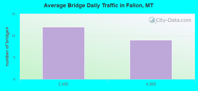
- 35,917Total average daily traffic
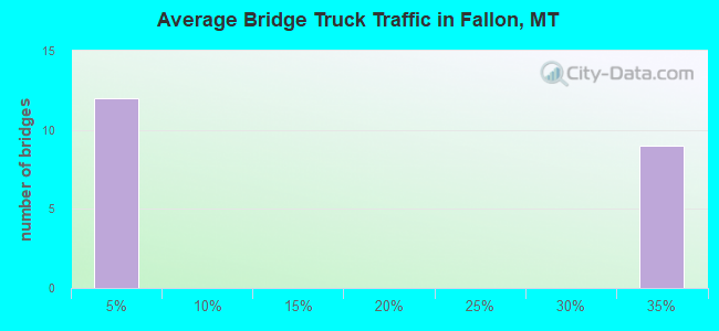
- 10,690Total average daily truck traffic
- National Bridge Inventory (NBI) Registered Bridges for Fallon
- No street view available for this location
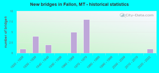
- New bridges - historical statistics
- 11920-1929
- 41930-1939
- 21940-1949
- 51960-1969
- 81970-1979
- 12020-2022
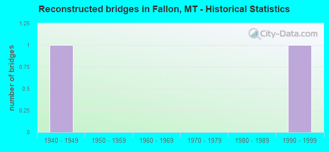
- Reconstructed bridges - Historical Statistics
- 11940-1949
- 01950-1959
- 01960-1969
- 01970-1979
- 01980-1989
- 11990-1999
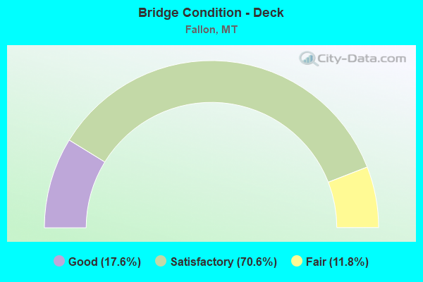
- Bridge Condition - Deck
- 17.6%Good
- 70.6%Satisfactory
- 11.8%Fair
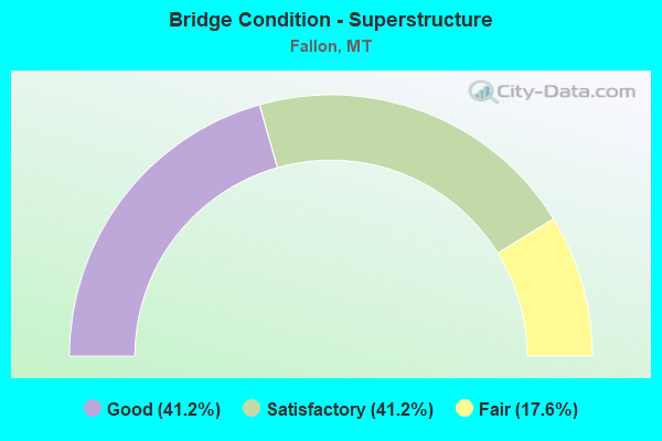
- Bridge Condition - Superstructure
- 41.2%Good
- 41.2%Satisfactory
- 17.6%Fair
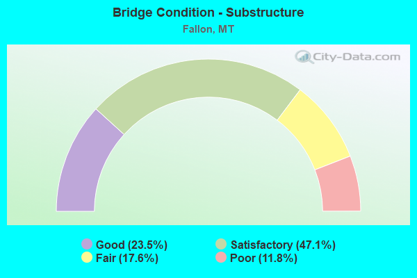
- Bridge Condition - Substructure
- 23.5%Good
- 47.1%Satisfactory
- 17.6%Fair
- 11.8%Poor
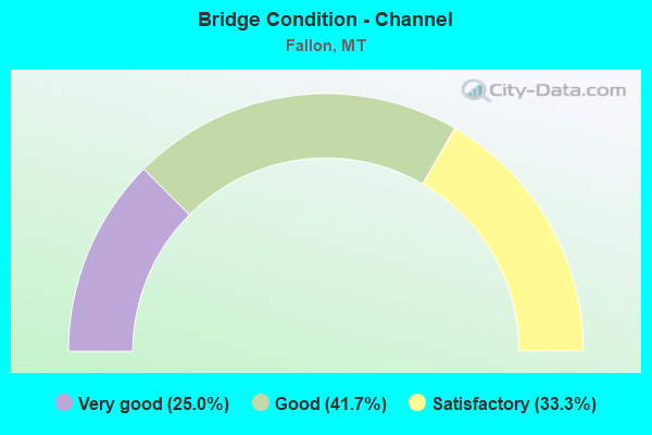
- Bridge Condition - Channel
- 25.0%Very good
- 41.7%Good
- 33.3%Satisfactory
Find on map >> Show street view
Structure Number: 202006689, Location: 1M SE FALLON (Lat: 46.828061, Lng: -105.105169), Route carried "on" structure: State highway 340, Year Built: 2020, Status: Open, Structure Length: 0.91m (2.99ft), Average Daily Traffic: 259 (year 2020), Truck Traffic: 4%, Average Future Daily Traffic: 272 (year 2040), Design Load: HL 93, Features Intersected: PLUM COULEE CREEK
Minimum Vertical Clearance: 30+ m (98+ ft), Kilometerpoint: 2.797, Lanes on structure: 2, Base Highway Network: Yes, Owner: State Highway Agency, Approaching Roadway Width: 8.6m (28.2ft), Material/Design: Concrete, Design/Construction: Culvert, Number Of Spans In Main Unit: 2, Length of Maximum Span: 4.3m (14.1ft)
Condition: Channel: Very good, Culverts: Good, Operating Rating: 50.8 metric tons, Method Used To Determine Operating Rating: Load and Resistance Factor (LRFR), Inventory Rating: 39.0 metric tons, Method Used To Determine Inventory Rating: Load and Resistance Factor (LRFR), Structural Evaluation: Better than present minimum criteria, Waterway Adequacy: Equal to present desirable criteria, Approach Roadway Alignment: Equal to present desirable criteria, Designated Inspection Frequency: Every 24 months, Inspection Date: December 2020
Find on map >> Show street view
Structure Number: I00094184+01151, Location: 1M SW FALLON (Lat: 46.824850, Lng: -105.154706), Route carried "on" structure: Interstate 94, Year Built: 1969, Status: Open, Structure Length: 8.41m (27.59ft), Average Daily Traffic: 3,721 (year 2020), Truck Traffic: 32%, Average Future Daily Traffic: 3,907 (year 2040), Design Load: HS 20, Features Intersected: O`FALLON CREEK
Minimum Vertical Clearance: 30+ m (98+ ft), Kilometerpoint: 295.381, Lanes on structure: 2, Base Highway Network: Yes, Owner: State Highway Agency, Approaching Roadway Width: 11.4m (37.4ft), Skew: 2 degrees, Material/Design: Prestressed concrete, Design/Construction: Stringer/Multi-beam, Number Of Spans In Main Unit: 3, Length of Maximum Span: 28.0m (91.9ft), Curb or Sidewalk Widths: Left: 0.1m (0.3ft), Right: 0.1m (0.3ft), Curb-To-Curb Width: 12.6m (41.3ft), Out-to-Out Width: 13.5m (44.3ft)
Condition: Deck: Satisfactory, Superstructure: Good, Substructure: Good, Channel: Satisfactory, Operating Rating: 60.8 metric tons, Method Used To Determine Operating Rating: Load and Resistance Factor (LRFR), Inventory Rating: 38.1 metric tons, Method Used To Determine Inventory Rating: Load and Resistance Factor (LRFR), Structural Evaluation: Better than present minimum criteria, Deck Geometry: Better than present minimum criteria, Waterway Adequacy: Equal to present desirable criteria, Approach Roadway Alignment: Equal to present desirable criteria, Designated Inspection Frequency: Every 48 months, Inspection Date: May 2020, Deck Structure Type: Concrete Cast-file-Place, Wearing Surface/Protective System: Wearing Surface: Monolithic Concrete
Find on map >> Show street view
Structure Number: I00094184+01152, Location: 1M SW FALLON (Lat: 46.825089, Lng: -105.154969), Route carried "on" structure: Interstate 94, Year Built: 1969, Status: Open, Structure Length: 8.41m (27.59ft), Average Daily Traffic: 3,721 (year 2020), Truck Traffic: 32%, Average Future Daily Traffic: 3,907 (year 2040), Design Load: HS 20, Features Intersected: O`FALLON CREEK
Minimum Vertical Clearance: 30+ m (98+ ft), Kilometerpoint: 296.227, Lanes on structure: 2, Base Highway Network: Yes, Owner: State Highway Agency, Approaching Roadway Width: 11.4m (37.4ft), Skew: 2 degrees, Material/Design: Prestressed concrete, Design/Construction: Stringer/Multi-beam, Number Of Spans In Main Unit: 3, Length of Maximum Span: 28.0m (91.9ft), Curb or Sidewalk Widths: Left: 0.1m (0.3ft), Right: 0.1m (0.3ft), Curb-To-Curb Width: 12.6m (41.3ft), Out-to-Out Width: 13.5m (44.3ft)
Condition: Deck: Fair, Superstructure: Good, Substructure: Good, Channel: Satisfactory, Operating Rating: 56.2 metric tons, Method Used To Determine Operating Rating: Load and Resistance Factor (LRFR), Inventory Rating: 38.1 metric tons, Method Used To Determine Inventory Rating: Load and Resistance Factor (LRFR), Structural Evaluation: Better than present minimum criteria, Deck Geometry: Better than present minimum criteria, Waterway Adequacy: Equal to present desirable criteria, Approach Roadway Alignment: Equal to present desirable criteria, Designated Inspection Frequency: Every 24 months, Inspection Date: May 2020, Deck Structure Type: Concrete Cast-file-Place, Wearing Surface/Protective System: Wearing Surface: Monolithic Concrete
Find on map >> Show street view
Structure Number: I00094185+00821, Location: SW FALLON (Lat: 46.832192, Lng: -105.137489), Route carried "on" structure: Interstate 94, Year Built: 1977, Status: Open, Structure Length: 6.92m (22.70ft), Average Daily Traffic: 3,721 (year 2020), Truck Traffic: 32%, Average Future Daily Traffic: 3,907 (year 2040), Design Load: HS 20, Features Intersected: RR
Minimum Vertical Clearance: 30+ m (98+ ft), Kilometerpoint: 296.962, Lanes on structure: 2, Base Highway Network: Yes, Owner: State Highway Agency, Approaching Roadway Width: 11.4m (37.4ft), Skew: 4 degrees, Material/Design: Prestressed concrete, Design/Construction: Stringer/Multi-beam, Number Of Spans In Main Unit: 3, Length of Maximum Span: 23.2m (76.1ft), Curb or Sidewalk Widths: Left: 0.1m (0.3ft), Right: 0.1m (0.3ft), Curb-To-Curb Width: 12.7m (41.7ft), Out-to-Out Width: 13.5m (44.3ft)
Condition: Deck: Satisfactory, Superstructure: Satisfactory, Substructure: Satisfactory, Operating Rating: 46.3 metric tons, Method Used To Determine Operating Rating: Load and Resistance Factor (LRFR), Inventory Rating: 24.5 metric tons, Method Used To Determine Inventory Rating: Load and Resistance Factor (LRFR), Structural Evaluation: Equal to present minimum criteria, Deck Geometry: Better than present minimum criteria, Underclear: Superior to present desirable criteria, Approach Roadway Alignment: Equal to present minimum criteria, Designated Inspection Frequency: Every 24 months, Inspection Date: May 2020, Deck Structure Type: Concrete Cast-file-Place, Wearing Surface/Protective System: Wearing Surface: Monolithic Concrete
Find on map >> Show street view
Structure Number: I00094185+00822, Location: SW FALLON (Lat: 46.832100, Lng: -105.138058), Route carried "on" structure: Interstate 94, Year Built: 1977, Status: Open, Structure Length: 7.07m (23.20ft), Average Daily Traffic: 3,773 (year 2020), Truck Traffic: 31%, Average Future Daily Traffic: 3,962 (year 2040), Design Load: HS 20, Features Intersected: RR
Minimum Vertical Clearance: 30+ m (98+ ft), Kilometerpoint: 297.765, Lanes on structure: 2, Base Highway Network: Yes, Owner: State Highway Agency, Approaching Roadway Width: 11.4m (37.4ft), Skew: 4 degrees, Material/Design: Prestressed concrete, Design/Construction: Stringer/Multi-beam, Number Of Spans In Main Unit: 3, Length of Maximum Span: 23.8m (78.1ft), Curb or Sidewalk Widths: Left: 0.1m (0.3ft), Right: 0.1m (0.3ft), Curb-To-Curb Width: 12.7m (41.7ft), Out-to-Out Width: 13.5m (44.3ft)
Condition: Deck: Satisfactory, Superstructure: Good, Substructure: Satisfactory, Operating Rating: 44.5 metric tons, Method Used To Determine Operating Rating: Load and Resistance Factor (LRFR), Inventory Rating: 22.7 metric tons, Method Used To Determine Inventory Rating: Load and Resistance Factor (LRFR), Structural Evaluation: Somewhat better than minimum adequacy, Deck Geometry: Better than present minimum criteria, Underclear: Superior to present desirable criteria, Approach Roadway Alignment: Equal to present minimum criteria, Designated Inspection Frequency: Every 24 months, Inspection Date: Febuary 2022, Deck Structure Type: Concrete Cast-file-Place, Wearing Surface/Protective System: Wearing Surface: Monolithic Concrete
Find on map >> Show street view
Structure Number: I00094186+09711, Location: 1M N FALLON (Lat: 46.855878, Lng: -105.117269), Route carried "on" structure: Interstate 94, Year Built: 1978, Status: Open, Structure Length: 35.64m (116.93ft), Average Daily Traffic: 3,773 (year 2020), Truck Traffic: 31%, Average Future Daily Traffic: 3,962 (year 2040), Design Load: HL 93, Features Intersected: YELLOWSTONE RIVER
Minimum Vertical Clearance: 30+ m (98+ ft), Kilometerpoint: 300.013, Lanes on structure: 2, Base Highway Network: Yes, Owner: State Highway Agency, Approaching Roadway Width: 11.6m (38.1ft), Material/Design: Steel continuous, Design/Construction: Stringer/Multi-beam, Number Of Spans In Main Unit: 4, Number Of Approach Spans: 2, Length of Maximum Span: 86.9m (285.1ft), Curb or Sidewalk Widths: Left: 0.1m (0.3ft), Right: 0.1m (0.3ft), Curb-To-Curb Width: 12.6m (41.3ft), Out-to-Out Width: 13.4m (44.0ft)
Condition: Deck: Satisfactory, Superstructure: Satisfactory, Substructure: Satisfactory, Channel: Good, Operating Rating: 41.7 metric tons, Method Used To Determine Operating Rating: Load and Resistance Factor (LRFR), Inventory Rating: 32.7 metric tons, Method Used To Determine Inventory Rating: Load and Resistance Factor (LRFR), Structural Evaluation: Equal to present minimum criteria, Deck Geometry: Better than present minimum criteria, Waterway Adequacy: Equal to present desirable criteria, Approach Roadway Alignment: Equal to present minimum criteria, Designated Inspection Frequency: Every 24 months, Underwater Inspection Frequency: Every 60 months, Inspection Date: October 2021, Underwater Inspection Date: October 2020, Deck Structure Type: Concrete Cast-file-Place, Wearing Surface/Protective System: Wearing Surface: Monolithic Concrete
Find on map >> Show street view
Structure Number: I00094186+09712, Location: 1M N FALLON (Lat: 46.855867, Lng: -105.117761), Route carried "on" structure: Interstate 94, Year Built: 1978, Status: Open, Structure Length: 35.64m (116.93ft), Average Daily Traffic: 3,773 (year 2020), Truck Traffic: 31%, Average Future Daily Traffic: 3,962 (year 2040), Design Load: HL 93, Features Intersected: YELLOWSTONE RIVER
Minimum Vertical Clearance: 5.00m (16.40ft), Kilometerpoint: 300.828, Lanes on structure: 2, Owner: State Highway Agency, Approaching Roadway Width: 11.6m (38.1ft), Material/Design: Steel continuous, Design/Construction: Stringer/Multi-beam, Number Of Spans In Main Unit: 4, Number Of Approach Spans: 2, Length of Maximum Span: 86.9m (285.1ft), Curb or Sidewalk Widths: Left: 0.1m (0.3ft), Right: 0.1m (0.3ft), Curb-To-Curb Width: 12.6m (41.3ft), Out-to-Out Width: 13.5m (44.3ft)
Condition: Deck: Satisfactory, Superstructure: Fair, Substructure: Satisfactory, Channel: Good, Operating Rating: 41.7 metric tons, Method Used To Determine Operating Rating: Load and Resistance Factor (LRFR), Inventory Rating: 32.7 metric tons, Method Used To Determine Inventory Rating: Load and Resistance Factor (LRFR), Structural Evaluation: Somewhat better than minimum adequacy, Deck Geometry: Better than present minimum criteria, Waterway Adequacy: Equal to present desirable criteria, Approach Roadway Alignment: Equal to present desirable criteria, Designated Inspection Frequency: Every 24 months, Underwater Inspection Frequency: Every 60 months, Inspection Date: October 2021, Underwater Inspection Date: October 2020, Deck Structure Type: Concrete Cast-file-Place, Wearing Surface/Protective System: Wearing Surface: Monolithic Concrete
Find on map >> Show street view
Structure Number: L40004021+03001, Location: 1M W FALLON (Lat: 46.829778, Lng: -105.144528), Route carried "on" structure: ServiceState highway 81020, Year Built: 1948, Status: Open, Structure Length: 6.83m (22.41ft), Average Daily Traffic: 437 (year 2020), Truck Traffic: 3%, Average Future Daily Traffic: 459 (year 2040), Design Load: HS 15, Features Intersected: O`FALLON CREEK 043, Facility Carried by Structure: OLD HWY 10 E
Minimum Vertical Clearance: 30+ m (98+ ft), Kilometerpoint: 46.777, Lanes on structure: 2, Owner: State Highway Agency, Approaching Roadway Width: 7.6m (24.9ft), Material/Design: Steel continuous, Design/Construction: Stringer/Multi-beam, Number Of Spans In Main Unit: 2, Length of Maximum Span: 33.5m (109.9ft), Curb-To-Curb Width: 8.5m (27.9ft), Out-to-Out Width: 9.7m (31.8ft)
Condition: Deck: Satisfactory, Superstructure: Satisfactory, Substructure: Satisfactory, Channel: Satisfactory, Operating Rating: 20.9 metric tons, Method Used To Determine Operating Rating: Load and Resistance Factor (LRFR), Inventory Rating: 16.3 metric tons, Method Used To Determine Inventory Rating: Load and Resistance Factor (LRFR), Structural Evaluation: Somewhat better than minimum adequacy, Deck Geometry: Somewhat better than minimum adequacy, Waterway Adequacy: Equal to present desirable criteria, Approach Roadway Alignment: Equal to present desirable criteria, Designated Inspection Frequency: Every 24 months, Inspection Date: July 2021, Deck Structure Type: Concrete Cast-file-Place, Wearing Surface/Protective System: Wearing Surface: Monolithic Concrete
Find on map >> Show street view
Structure Number: L40004021+04001, Location: 1M W FALLON (Lat: 46.832008, Lng: -105.138544), Route carried "on" structure: ServiceState highway 81020, Year Built: 1934, Year Reconstructed: 1949, Status: Open, Structure Length: 4.50m (14.76ft), Average Daily Traffic: 437 (year 2020), Truck Traffic: 3%, Average Future Daily Traffic: 459 (year 2040), Design Load: H 15, Features Intersected: RR 046, Facility Carried by Structure: OLD HWY 10 E
Minimum Vertical Clearance: 30+ m (98+ ft), Kilometerpoint: 47.324, Lanes on structure: 2, Owner: State Highway Agency, Approaching Roadway Width: 7.6m (24.9ft), Skew: 4 degrees, Material/Design: Concrete, Design/Construction: Tee Beam, Number Of Spans In Main Unit: 3, Length of Maximum Span: 15.5m (50.9ft), Curb-To-Curb Width: 8.6m (28.2ft), Out-to-Out Width: 10.5m (34.4ft)
Condition: Deck: Satisfactory, Superstructure: Satisfactory, Substructure: Satisfactory, Operating Rating: 50.8 metric tons, Method Used To Determine Operating Rating: Allowable Stress (AS), Inventory Rating: 17.2 metric tons, Method Used To Determine Inventory Rating: Allowable Stress (AS), Structural Evaluation: Somewhat better than minimum adequacy, Deck Geometry: Somewhat better than minimum adequacy, Underclear: Meets minimum limits, Approach Roadway Alignment: Equal to present minimum criteria, Length Of Structure Improvement: 5.40m (17.72ft), Designated Inspection Frequency: Every 24 months, Inspection Date: May 2020, Bridge Improvement Cost: $294,000, Roadway Improvement Cost: $29,000, Total Project Cost: $323,000, Deck Structure Type: Concrete Cast-file-Place, Wearing Surface/Protective System: Wearing Surface: Bituminous
Find on map >> Show street view
Structure Number: L40108001+02001, Location: 3M NE FALLON (Lat: 46.859306, Lng: -105.084889), Route carried "on" structure: County highway 40108, Year Built: 1928, Status: Open, Structure Length: 1.97m (6.46ft), Average Daily Traffic: 70 (year 2020), Truck Traffic: 3%, Average Future Daily Traffic: 74 (year 2040), Design Load: H 15, Features Intersected: BR MAIN CANAL 035, Facility Carried by Structure: CB ROUTE RD
Minimum Vertical Clearance: 30+ m (98+ ft), Kilometerpoint: 39.900, Lanes on structure: 2, Owner: County Highway Agency, Approaching Roadway Width: 7.3m (24.0ft), Material/Design: Steel, Design/Construction: Stringer/Multi-beam, Number Of Spans In Main Unit: 2, Length of Maximum Span: 9.4m (30.8ft), Curb or Sidewalk Widths: Left: 0.4m (1.3ft), Right: 0.4m (1.3ft), Curb-To-Curb Width: 6.1m (20.0ft), Out-to-Out Width: 6.9m (22.6ft)
Condition: Deck: Fair, Superstructure: Satisfactory, Substructure: Poor, Channel: Good, Operating Rating: 55.3 metric tons, Method Used To Determine Operating Rating: Load Factor (LF), Inventory Rating: 33.6 metric tons, Method Used To Determine Inventory Rating: Load Factor (LF), Structural Evaluation: Meets minimum limits, Deck Geometry: Somewhat better than minimum adequacy, Waterway Adequacy: Equal to present desirable criteria, Approach Roadway Alignment: Equal to present minimum criteria, Length Of Structure Improvement: 2.70m (8.86ft), Designated Inspection Frequency: Every 24 months, Inspection Date: January 2021, Bridge Improvement Cost: $76,000, Roadway Improvement Cost: $8,000, Total Project Cost: $83,000, Deck Structure Type: Concrete Cast-file-Place, Wearing Surface/Protective System: Wearing Surface: Bituminous
Find on map >> Show street view
Structure Number: L40108001+04001, Location: 3M NE FALLON (Lat: 46.861064, Lng: -105.080719), Route carried "on" structure: County highway 40108, Year Built: 1938, Status: Open, Structure Length: 2.06m (6.76ft), Average Daily Traffic: 70 (year 2020), Truck Traffic: 3%, Average Future Daily Traffic: 74 (year 2040), Design Load: HS 20, Features Intersected: BR MAIN CANAL 036, Facility Carried by Structure: CB ROUTE RD
Minimum Vertical Clearance: 30+ m (98+ ft), Kilometerpoint: 39.528, Lanes on structure: 2, Owner: County Highway Agency, Approaching Roadway Width: 7.6m (24.9ft), Skew: 5 degrees, Material/Design: Wood or Timber, Design/Construction: Stringer/Multi-beam, Number Of Spans In Main Unit: 3, Length of Maximum Span: 6.7m (22.0ft), Curb or Sidewalk Widths: Left: 0.2m (0.7ft), Right: 0.2m (0.7ft), Curb-To-Curb Width: 8.0m (26.2ft), Out-to-Out Width: 8.6m (28.2ft)
Condition: Deck: Satisfactory, Superstructure: Satisfactory, Substructure: Fair, Channel: Very good, Operating Rating: 48.1 metric tons, Method Used To Determine Operating Rating: Load and Resistance Factor (LRFR), Inventory Rating: 36.3 metric tons, Method Used To Determine Inventory Rating: Load and Resistance Factor (LRFR), Structural Evaluation: Somewhat better than minimum adequacy, Deck Geometry: Equal to present minimum criteria, Waterway Adequacy: Equal to present desirable criteria, Approach Roadway Alignment: Equal to present desirable criteria, Length Of Structure Improvement: 2.80m (9.19ft), Designated Inspection Frequency: Every 24 months, Inspection Date: January 2021, Bridge Improvement Cost: $113,000, Roadway Improvement Cost: $11,000, Total Project Cost: $125,000, Deck Structure Type: Wood or Timber, Wearing Surface/Protective System: Wearing Surface: Bituminous
Find on map >> Show street view
Structure Number: L40108002+04001, Location: 4M NE FALLON (Lat: 46.868503, Lng: -105.064100), Route carried "on" structure: County highway 40108, Year Built: 1966, Status: Open, Structure Length: 0.77m (2.53ft), Average Daily Traffic: 70 (year 2020), Truck Traffic: 3%, Average Future Daily Traffic: 74 (year 2040), Design Load: HS 20, Features Intersected: BR MAIN CANAL 037, Facility Carried by Structure: CB ROUTE RD
Minimum Vertical Clearance: 30+ m (98+ ft), Kilometerpoint: 38.022, Lanes on structure: 2, Owner: County Highway Agency, Approaching Roadway Width: 7.6m (24.9ft), Skew: 5 degrees, Material/Design: Prestressed concrete, Design/Construction: Tee Beam, Number Of Spans In Main Unit: 1, Length of Maximum Span: 7.7m (25.3ft), Curb or Sidewalk Widths: Left: 0.3m (1.0ft), Right: 0.3m (1.0ft), Curb-To-Curb Width: 6.8m (22.3ft), Out-to-Out Width: 7.3m (24.0ft)
Condition: Deck: Good, Superstructure: Good, Substructure: Fair, Channel: Very good, Operating Rating: 47.1 metric tons, Method Used To Determine Operating Rating: Allowable Stress (AS), Inventory Rating: 28.1 metric tons, Method Used To Determine Inventory Rating: Allowable Stress (AS), Structural Evaluation: Somewhat better than minimum adequacy, Deck Geometry: Somewhat better than minimum adequacy, Waterway Adequacy: Equal to present desirable criteria, Approach Roadway Alignment: Equal to present desirable criteria, Designated Inspection Frequency: Every 24 months, Inspection Date: January 2021, Deck Structure Type: Concrete Precast Panels, Wearing Surface/Protective System: Wearing Surface: Bituminous
Find on map >> Show street view
Structure Number: L40108003+00001, Location: 5M NE FALLON (Lat: 46.873450, Lng: -105.053050), Route carried "on" structure: County highway 40108, Year Built: 1939, Status: Posted for load, Structure Length: 1.19m (3.90ft), Average Daily Traffic: 70 (year 2020), Truck Traffic: 3%, Average Future Daily Traffic: 74 (year 2040), Design Load: H 15, Features Intersected: BUFFALO RAPIDS CANAL042, Facility Carried by Structure: CB ROUTE RD
Minimum Vertical Clearance: 30+ m (98+ ft), Kilometerpoint: 37.006, Lanes on structure: 2, Owner: County Highway Agency, Approaching Roadway Width: 7.6m (24.9ft), Material/Design: Wood or Timber, Design/Construction: Stringer/Multi-beam, Number Of Spans In Main Unit: 2, Length of Maximum Span: 5.8m (19.0ft), Curb or Sidewalk Widths: Left: 0.2m (0.7ft), Right: 0.2m (0.7ft), Curb-To-Curb Width: 8.0m (26.2ft), Out-to-Out Width: 8.5m (27.9ft)
Condition: Deck: Satisfactory, Superstructure: Good, Substructure: Poor, Channel: Satisfactory, Operating Rating: 27.2 metric tons, Method Used To Determine Operating Rating: Allowable Stress (AS), Inventory Rating: 18.1 metric tons, Method Used To Determine Inventory Rating: Allowable Stress (AS), Structural Evaluation: Meets minimum limits, Deck Geometry: Equal to present minimum criteria, Waterway Adequacy: Equal to present desirable criteria, Approach Roadway Alignment: Equal to present desirable criteria, Bridge Posting: Required (Relationship of Operating Rating to Maximum Legal Load: 20.0 - 29.9% below), Length Of Structure Improvement: 1.51m (4.95ft), Designated Inspection Frequency: Every 24 months, Other Special Inspection Frequency: Every 1 months, Inspection Date: January 2021, Other Special Inspection Date: March 2022, Bridge Improvement Cost: $59,000, Roadway Improvement Cost: $12,000, Total Project Cost: $74,000, Deck Structure Type: Wood or Timber, Wearing Surface/Protective System: Wearing Surface: Bituminous
Find on map >> Show street view
Structure Number: L40114001+05001, Location: 1M NE FALLON (Lat: 46.855353, Lng: -105.116764), Route carried "on" structure: ServiceState highway 40114, Year Built: 1945, Status: Open, Structure Length: 34.89m (114.47ft), Average Daily Traffic: 100 (year 2022), Truck Traffic: 3%, Average Future Daily Traffic: 100 (year 2037), Design Load: H 15, Features Intersected: YELLOWSTONE RIVER 015, Facility Carried by Structure: FRONTAGE ROAD 114
Minimum Vertical Clearance: 4.54m (14.90ft), Kilometerpoint: 2.482, Lanes on structure: 2, Owner: State Highway Agency, Approaching Roadway Width: 7.6m (24.9ft), Material/Design: Steel continuous, Design/Construction: Truss - Thru, Number Of Spans In Main Unit: 4, Length of Maximum Span: 87.1m (285.8ft), Curb or Sidewalk Widths: Left: 0.5m (1.6ft), Right: 0.5m (1.6ft), Curb-To-Curb Width: 7.9m (25.9ft), Out-to-Out Width: 9.0m (29.5ft)
Condition: Deck: Satisfactory, Superstructure: Fair, Substructure: Satisfactory, Channel: Good, Operating Rating: 28.1 metric tons, Method Used To Determine Operating Rating: Load Factor (LF), Inventory Rating: 17.2 metric tons, Method Used To Determine Inventory Rating: Load Factor (LF), Structural Evaluation: Somewhat better than minimum adequacy, Deck Geometry: Equal to present minimum criteria, Waterway Adequacy: Equal to present desirable criteria, Approach Roadway Alignment: Equal to present minimum criteria, Designated Inspection Frequency: Every 24 months, Critical Feature Inspection Frequency: Every 24 months, Underwater Inspection Frequency: Every 60 months, Inspection Date: July 2021, Critical Feature Inspection Date: July 2021, Underwater Inspection Date: October 2020, Deck Structure Type: Concrete Cast-file-Place, Wearing Surface/Protective System: Wearing Surface: Monolithic Concrete
Find on map >> Show street view
Structure Number: L40114002+01001, Location: 2M NE FALLON (Lat: 46.865314, Lng: -105.104533), Route carried "on" structure: ServiceState highway 40114, Year Built: 1977, Status: Open, Structure Length: 9.31m (30.54ft), Average Daily Traffic: 100 (year 2022), Truck Traffic: 3%, Average Future Daily Traffic: 100 (year 2037), Design Load: HS 20, Features Intersected: SEP I 94 003, Facility Carried by Structure: FALLON TOWER RD
Minimum Vertical Clearance: 30+ m (98+ ft), Kilometerpoint: 3.963, Lanes on structure: 2, Lanes under structure: 4, Owner: State Highway Agency, Approaching Roadway Width: 7.3m (24.0ft), Material/Design: Prestressed concrete, Design/Construction: Stringer/Multi-beam, Number Of Spans In Main Unit: 4, Length of Maximum Span: 32.3m (106.0ft), Curb or Sidewalk Widths: Left: 0.1m (0.3ft), Right: 0.1m (0.3ft), Curb-To-Curb Width: 8.4m (27.6ft), Out-to-Out Width: 9.2m (30.2ft)
Condition: Deck: Good, Superstructure: Good, Substructure: Good, Operating Rating: 65.3 metric tons, Method Used To Determine Operating Rating: Assigned rating based on Load Factor Design (LFD) reported in metric tons, Inventory Rating: 32.7 metric tons, Method Used To Determine Inventory Rating: Assigned rating based on Load Factor Design (LFD) reported in metric tons, Structural Evaluation: Better than present minimum criteria, Deck Geometry: Equal to present minimum criteria, Underclear: Equal to present desirable criteria, Approach Roadway Alignment: Equal to present minimum criteria, Designated Inspection Frequency: Every 24 months, Inspection Date: January 2021, Deck Structure Type: Concrete Cast-file-Place, Wearing Surface/Protective System: Wearing Surface: Monolithic Concrete
Find on map >> Show street view
Structure Number: L40119000+03001, Location: 5M NE FALLON (Lat: 46.876328, Lng: -105.048611), Route carried "on" structure: County highway 40119, Year Built: 1936, Year Reconstructed: 2004, Status: Posted for load, Structure Length: 1.22m (4.00ft), Average Daily Traffic: 100 (year 2022), Truck Traffic: 3%, Average Future Daily Traffic: 100 (year 2037), Features Intersected: BR MAIN CANAL 038, Facility Carried by Structure: COUNTY ROAD 119
Minimum Vertical Clearance: 30+ m (98+ ft), Kilometerpoint: 0.084, Lanes on structure: 2, Owner: County Highway Agency, Approaching Roadway Width: 4.9m (16.1ft), Material/Design: Steel, Design/Construction: Stringer/Multi-beam, Number Of Spans In Main Unit: 2, Length of Maximum Span: 6.1m (20.0ft), Curb-To-Curb Width: 5.5m (18.0ft), Out-to-Out Width: 5.5m (18.0ft)
Condition: Deck: Satisfactory, Superstructure: Fair, Substructure: Fair, Channel: Good, Operating Rating: 10.9 metric tons, Method Used To Determine Operating Rating: Load and Resistance Factor (LRFR), Inventory Rating: 8.2 metric tons, Method Used To Determine Inventory Rating: Load and Resistance Factor (LRFR), Structural Evaluation: High priority of corrective action, Waterway Adequacy: Equal to present desirable criteria, Approach Roadway Alignment: Meets minimum limits, Bridge Posting: Required (Relationship of Operating Rating to Maximum Legal Load: > 39.9% below), Designated Inspection Frequency: Every 24 months, Inspection Date: January 2021, Deck Structure Type: Wood or Timber, Wearing Surface/Protective System: Wearing Surface: Wood or Timber
Find on map >> Show street view
Structure Number: L40168004+00001, Location: 2M SW FALLON (Lat: 46.819342, Lng: -105.174931), Route carried "on" structure: ServiceCounty highway 40168, Year Built: 1969, Status: Open, Structure Length: 10.26m (33.66ft), Average Daily Traffic: 100 (year 2022), Truck Traffic: 3%, Average Future Daily Traffic: 100 (year 2037), Design Load: HS 20, Features Intersected: SEP I 94 001, Facility Carried by Structure: FRONTAGE ROAD 168
Minimum Vertical Clearance: 30+ m (98+ ft), Kilometerpoint: 4.677, Lanes on structure: 2, Lanes under structure: 4, Owner: State Highway Agency, Approaching Roadway Width: 8.0m (26.2ft), Skew: 2 degrees, Material/Design: Steel continuous, Design/Construction: Stringer/Multi-beam, Number Of Spans In Main Unit: 5, Length of Maximum Span: 29.0m (95.1ft), Curb or Sidewalk Widths: Left: 0.1m (0.3ft), Right: 0.1m (0.3ft), Curb-To-Curb Width: 8.4m (27.6ft), Out-to-Out Width: 9.2m (30.2ft)
Condition: Deck: Good, Superstructure: Satisfactory, Substructure: Good, Operating Rating: 42.6 metric tons, Method Used To Determine Operating Rating: Load Factor (LF), Inventory Rating: 25.4 metric tons, Method Used To Determine Inventory Rating: Load Factor (LF), Structural Evaluation: Equal to present minimum criteria, Deck Geometry: Equal to present minimum criteria, Underclear: Meets minimum limits, Approach Roadway Alignment: Equal to present minimum criteria, Designated Inspection Frequency: Every 24 months, Inspection Date: July 2021, Deck Structure Type: Concrete Cast-file-Place, Wearing Surface/Protective System: Wearing Surface: Monolithic Concrete
Find on map >> Show street view
Structure Number: S00340000+04871, Location: FALLON (Lat: 46.837278, Lng: -105.133839), Route carried "on" structure: State highway 340, Year Built: 1978, Status: Open, Structure Length: 8.39m (27.53ft), Average Daily Traffic: 407 (year 2020), Truck Traffic: 2%, Average Future Daily Traffic: 427 (year 2040), Design Load: HS 20, Features Intersected: INT FALLON-I 94
Minimum Vertical Clearance: 30+ m (98+ ft), Kilometerpoint: 0.000, Lanes on structure: 2, Lanes under structure: 4, Owner: State Highway Agency, Approaching Roadway Width: 10.1m (33.1ft), Material/Design: Prestressed concrete, Design/Construction: Stringer/Multi-beam, Number Of Spans In Main Unit: 4, Length of Maximum Span: 30.5m (100.1ft), Curb or Sidewalk Widths: Left: 0.1m (0.3ft), Right: 0.1m (0.3ft), Curb-To-Curb Width: 9.6m (31.5ft), Out-to-Out Width: 10.4m (34.1ft)
Condition: Deck: Satisfactory, Superstructure: Good, Substructure: Satisfactory, Operating Rating: 63.5 metric tons, Method Used To Determine Operating Rating: Assigned rating based on Load Factor Design (LFD) reported in metric tons, Inventory Rating: 32.7 metric tons, Method Used To Determine Inventory Rating: Assigned rating based on Load Factor Design (LFD) reported in metric tons, Structural Evaluation: Equal to present minimum criteria, Deck Geometry: Equal to present minimum criteria, Underclear: Better than present minimum criteria, Approach Roadway Alignment: Equal to present desirable criteria, Designated Inspection Frequency: Every 48 months, Inspection Date: Febuary 2019, Deck Structure Type: Concrete Cast-file-Place, Wearing Surface/Protective System: Wearing Surface: Monolithic Concrete
Find on map >> Show street view
Structure Number: L40114002+01001, Location: 2M NE FALLON (Lat: 46.865314, Lng: -105.104533), Route carried "under" structure: Interstate 94, Year Built: 1977, Structure Length: 0. m, Average Daily Traffic: 3,773 (year 2020), Truck Traffic: 31%, Features Intersected: SEP I 94 003, Facility Carried by Structure: FALLON TOWER RD
Minimum Vertical Clearance: 5.32m (17.45ft), Kilometerpoint: 301.468, Lanes on structure: 2, Lanes under structure: 4, Material/Design: Prestressed concrete, Design/Construction: Stringer/Multi-beam, Length of Maximum Span: 32.3m (106.0ft)
Find on map >> Show street view
Structure Number: L40168004+00001, Location: 2M SW FALLON (Lat: 46.819342, Lng: -105.174931), Route carried "under" structure: Interstate 94, Year Built: 1969, Structure Length: 0. m, Average Daily Traffic: 3,721 (year 2020), Truck Traffic: 32%, Features Intersected: SEP I 94 001, Facility Carried by Structure: FRONTAGE ROAD 168
Minimum Vertical Clearance: 5.39m (17.68ft), Kilometerpoint: 293.720, Lanes on structure: 2, Lanes under structure: 4, Material/Design: Steel continuous, Design/Construction: Stringer/Multi-beam, Length of Maximum Span: 29.0m (95.1ft)
Find on map >> Show street view
Structure Number: S00340000+04871, Location: FALLON (Lat: 46.837278, Lng: -105.133839), Route carried "under" structure: Interstate 94, Year Built: 1978, Structure Length: 0. m, Average Daily Traffic: 3,721 (year 2020), Truck Traffic: 32%, Features Intersected: INT FALLON-I 94, Facility Carried by Structure: S 340
Minimum Vertical Clearance: 5.00m (16.40ft), Kilometerpoint: 297.590, Lanes on structure: 2, Lanes under structure: 4, Material/Design: Prestressed concrete, Design/Construction: Stringer/Multi-beam, Length of Maximum Span: 30.5m (100.1ft)