Bridge Statistics for Fenton, Michigan (MI)
Condition, Traffic, Stress, Structural Evaluation, Project Costs
- National Bridge Inventory (NBI) Statistics
- 18Number of bridges
- 151ft / 46.2mTotal length
- $800,000Total costs
- 291,654Total average daily traffic
- 22,571Total average daily truck traffic
- National Bridge Inventory (NBI) Registered Bridges for Fenton
- No street view available for this location
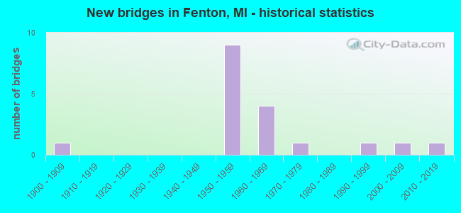
- New bridges - historical statistics
- 11900-1909
- 91950-1959
- 41960-1969
- 11970-1979
- 11990-1999
- 12000-2009
- 12010-2019
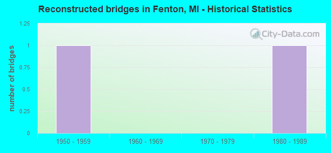
- Reconstructed bridges - Historical Statistics
- 11950-1959
- 01960-1969
- 01970-1979
- 11980-1989
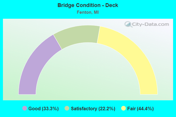
- Bridge Condition - Deck
- 33.3%Good
- 22.2%Satisfactory
- 44.4%Fair
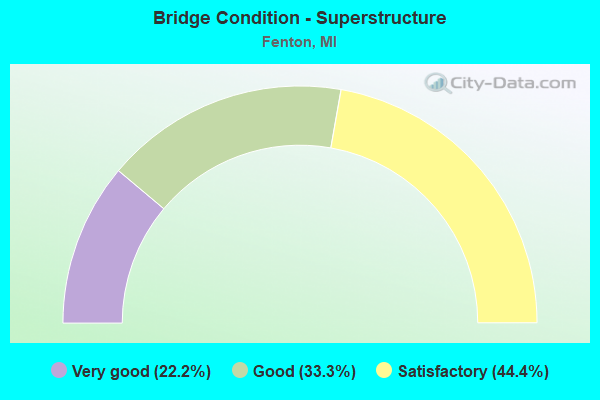
- Bridge Condition - Superstructure
- 22.2%Very good
- 33.3%Good
- 44.4%Satisfactory
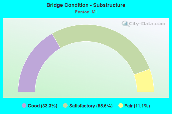
- Bridge Condition - Substructure
- 33.3%Good
- 55.6%Satisfactory
- 11.1%Fair
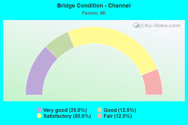
- Bridge Condition - Channel
- 25.0%Very good
- 12.5%Good
- 50.0%Satisfactory
- 12.5%Fair
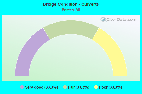
- Bridge Condition - Culverts
- 33.3%Very good
- 33.3%Fair
- 33.3%Poor
Find on map >> Show street view
Structure Number: 2466, Location: IN FENTON (Lat: 42.797714, Lng: -83.706489), Route carried "on" structure: City street , Year Built: 2016, Status: Open, Structure Length: 1.03m (3.38ft), Average Daily Traffic: 13,800 (year 2015), Truck Traffic: 10%, Average Future Daily Traffic: 15,800 (year 2035), Design Load: Greater than HL93, Features Intersected: SHIAWASSEE RIVER, Facility Carried by Structure: SILVER LAKE ROAD
Minimum Vertical Clearance: 30.48m (100.00ft), Kilometerpoint: 1.307, Lanes on structure: 2, Owner: City or Municipal Highway Agency, Approaching Roadway Width: 11.0m (36.1ft), Material/Design: Aluminum, Iron, Design/Construction: Culvert, Number Of Spans In Main Unit: 1, Length of Maximum Span: 10.3m (33.8ft), Curb or Sidewalk Widths: Left: 4.8m (15.7ft), Right: 2.7m (8.9ft), Curb-To-Curb Width: 11.0m (36.1ft), Out-to-Out Width: 19.2m (63.0ft)
Condition: Channel: Good, Culverts: Very good, Operating Rating: 69.7 metric tons, Method Used To Determine Operating Rating: Load and Resistance Factor Rating (LRFR) rating reported by rating factor(RF) method using HL-93 loadings, Inventory Rating: 53.8 metric tons, Method Used To Determine Inventory Rating: Load and Resistance Factor Rating (LRFR) rating reported by rating factor(RF) method using HL-93 loadings, Structural Evaluation: Equal to present desirable criteria, Deck Geometry: Meets minimum limits, Waterway Adequacy: Equal to present desirable criteria, Approach Roadway Alignment: Equal to present desirable criteria, Designated Inspection Frequency: Every 24 months, Inspection Date: September 2021, Wearing Surface/Protective System: Wearing Surface: Bituminous
Find on map >> Show street view
Structure Number: 2467, Location: IN FENTON (Lat: 42.815297, Lng: -83.725844), Route carried "on" structure: US 23, Year Built: 1957, Status: Open, Structure Length: 1.28m (4.20ft), Average Daily Traffic: 23,577 (year 2007), Truck Traffic: 9%, Average Future Daily Traffic: 37,269 (year 2018), Design Load: HS 20, Features Intersected: SHIAWASSEE RIVER
Minimum Vertical Clearance: 30.48m (100.00ft), Kilometerpoint: 4.046, Lanes on structure: 2, Base Highway Network: Yes (Inventory Route: 150, Subroute: 7), Owner: State Highway Agency, Approaching Roadway Width: 14.0m (45.9ft), Skew: 11 degrees, Material/Design: Steel, Design/Construction: Stringer/Multi-beam, Number Of Spans In Main Unit: 1, Length of Maximum Span: 12.8m (42.0ft), Curb-To-Curb Width: 13.1m (43.0ft), Out-to-Out Width: 14.4m (47.2ft)
Condition: Deck: Satisfactory, Superstructure: Good, Substructure: Satisfactory, Channel: Very good, Operating Rating: 89.1 metric tons, Method Used To Determine Operating Rating: Load Factor (LF), Inventory Rating: 53.3 metric tons, Method Used To Determine Inventory Rating: Load Factor (LF), Structural Evaluation: Equal to present minimum criteria, Deck Geometry: Superior to present desirable criteria, Waterway Adequacy: Equal to present desirable criteria, Approach Roadway Alignment: Equal to present desirable criteria, Designated Inspection Frequency: Every 24 months, Inspection Date: March 2022, Deck Structure Type: Concrete Cast-file-Place, Wearing Surface/Protective System: Wearing Surface: Latex Concrete
Find on map >> Show street view
Structure Number: 2468, Location: IN FENTON (Lat: 42.815289, Lng: -83.726128), Route carried "on" structure: US 23, Year Built: 1957, Status: Open, Structure Length: 1.28m (4.20ft), Average Daily Traffic: 23,577 (year 2007), Truck Traffic: 9%, Average Future Daily Traffic: 37,269 (year 2018), Design Load: HS 20, Features Intersected: SHIAWASSEE RIVER
Minimum Vertical Clearance: 30.48m (100.00ft), Kilometerpoint: 4.046, Lanes on structure: 2, Base Highway Network: Yes (Inventory Route: 150, Subroute: 7), Owner: State Highway Agency, Approaching Roadway Width: 14.0m (45.9ft), Skew: 11 degrees, Material/Design: Steel, Design/Construction: Stringer/Multi-beam, Number Of Spans In Main Unit: 1, Length of Maximum Span: 12.8m (42.0ft), Curb-To-Curb Width: 13.1m (43.0ft), Out-to-Out Width: 14.4m (47.2ft)
Condition: Deck: Fair, Superstructure: Good, Substructure: Satisfactory, Channel: Very good, Operating Rating: 89.1 metric tons, Method Used To Determine Operating Rating: Load Factor (LF), Inventory Rating: 53.3 metric tons, Method Used To Determine Inventory Rating: Load Factor (LF), Structural Evaluation: Equal to present minimum criteria, Deck Geometry: Superior to present desirable criteria, Waterway Adequacy: Equal to present desirable criteria, Approach Roadway Alignment: Equal to present desirable criteria, Designated Inspection Frequency: Every 24 months, Inspection Date: March 2022, Deck Structure Type: Concrete Cast-file-Place, Wearing Surface/Protective System: Wearing Surface: Latex Concrete
Find on map >> Show street view
Structure Number: 2475, Location: IN FENTON (Lat: 42.804358, Lng: -83.727442), Route carried "on" structure: US 23, Year Built: 1958, Status: Open, Structure Length: 10.15m (33.30ft), Average Daily Traffic: 23,577 (year 2007), Truck Traffic: 9%, Average Future Daily Traffic: 37,269 (year 2018), Design Load: HS 20, Features Intersected: US-23 BR & GTW RR
Minimum Vertical Clearance: 30.48m (100.00ft), Kilometerpoint: 2.778, Lanes on structure: 2, Lanes under structure: 4, Base Highway Network: Yes (Inventory Route: 150, Subroute: 7), Owner: State Highway Agency, Approaching Roadway Width: 15.8m (51.8ft), Skew: 10 degrees, Material/Design: Steel, Design/Construction: Stringer/Multi-beam, Number Of Spans In Main Unit: 5, Length of Maximum Span: 22.5m (73.8ft), Curb-To-Curb Width: 14.2m (46.6ft), Out-to-Out Width: 14.7m (48.2ft)
Condition: Deck: Fair, Superstructure: Satisfactory, Substructure: Satisfactory, Operating Rating: 66.4 metric tons, Method Used To Determine Operating Rating: Load Factor (LF) rating reported by rating factor (RF) method using MS18 loading, Inventory Rating: 39.5 metric tons, Method Used To Determine Inventory Rating: Load Factor (LF) rating reported by rating factor (RF) method using MS18 loading, Structural Evaluation: Equal to present minimum criteria, Deck Geometry: Superior to present desirable criteria, Underclear: Equal to present minimum criteria, Approach Roadway Alignment: Meets minimum limits, Designated Inspection Frequency: Every 24 months, Other Special Inspection Frequency: Every 12 months, Inspection Date: March 2022, Other Special Inspection Date: March 2022, Deck Structure Type: Concrete Cast-file-Place, Wearing Surface/Protective System: Wearing Surface: Latex Concrete, Deck Protection: Epoxy Coated Reinforcing
Find on map >> Show street view
Structure Number: 2476, Location: IN FENTON (Lat: 42.804450, Lng: -83.727742), Route carried "on" structure: US 23, Year Built: 1958, Status: Open, Structure Length: 10.15m (33.30ft), Average Daily Traffic: 23,577 (year 2007), Truck Traffic: 9%, Average Future Daily Traffic: 37,269 (year 2018), Design Load: HS 20, Features Intersected: US-23 BR & GTW RR
Minimum Vertical Clearance: 30.48m (100.00ft), Kilometerpoint: 2.787, Lanes on structure: 2, Lanes under structure: 4, Base Highway Network: Yes (Inventory Route: 150, Subroute: 7), Owner: State Highway Agency, Approaching Roadway Width: 14.6m (47.9ft), Skew: 10 degrees, Material/Design: Steel, Design/Construction: Stringer/Multi-beam, Number Of Spans In Main Unit: 5, Length of Maximum Span: 22.5m (73.8ft), Curb-To-Curb Width: 14.2m (46.6ft), Out-to-Out Width: 14.7m (48.2ft)
Condition: Deck: Fair, Superstructure: Satisfactory, Substructure: Satisfactory, Operating Rating: 66.4 metric tons, Method Used To Determine Operating Rating: Load Factor (LF) rating reported by rating factor (RF) method using MS18 loading, Inventory Rating: 39.5 metric tons, Method Used To Determine Inventory Rating: Load Factor (LF) rating reported by rating factor (RF) method using MS18 loading, Structural Evaluation: Equal to present minimum criteria, Deck Geometry: Superior to present desirable criteria, Underclear: Equal to present minimum criteria, Approach Roadway Alignment: Meets minimum limits, Designated Inspection Frequency: Every 24 months, Inspection Date: March 2022, Deck Structure Type: Concrete Cast-file-Place, Wearing Surface/Protective System: Wearing Surface: Latex Concrete, Deck Protection: Epoxy Coated Reinforcing
Find on map >> Show street view
Structure Number: 2477, Location: OWEN RD (1 MI W / FENTON) (Lat: 42.789733, Lng: -83.738417), Route carried "on" structure: US 23, Year Built: 1957, Year Reconstructed: 1994, Status: Open, Structure Length: 8.11m (26.61ft), Average Daily Traffic: 16,244 (year 2005), Truck Traffic: 3%, Average Future Daily Traffic: 19,132 (year 2018), Design Load: HS 20, Features Intersected: US-23
Minimum Vertical Clearance: 30.48m (100.00ft), Kilometerpoint: 3.909, Lanes on structure: 5, Lanes under structure: 6, Owner: State Highway Agency, Approaching Roadway Width: 12.2m (40.0ft), Skew: 3 degrees, Material/Design: Prestressed concrete, Design/Construction: Box Beam or Girders - Single/Spread, Number Of Spans In Main Unit: 4, Length of Maximum Span: 22.2m (72.8ft), Curb-To-Curb Width: 24.3m (79.7ft), Out-to-Out Width: 25.4m (83.3ft)
Condition: Deck: Fair, Superstructure: Satisfactory, Substructure: Fair, Operating Rating: 80.4 metric tons, Method Used To Determine Operating Rating: Load Factor (LF), Inventory Rating: 42.6 metric tons, Method Used To Determine Inventory Rating: Load Factor (LF), Structural Evaluation: Somewhat better than minimum adequacy, Deck Geometry: Superior to present desirable criteria, Underclear: High priority of corrective action, Approach Roadway Alignment: Equal to present desirable criteria, Designated Inspection Frequency: Every 24 months, Inspection Date: July 2020, Deck Structure Type: Concrete Cast-file-Place, Wearing Surface/Protective System: Wearing Surface: Monolithic Concrete, Deck Protection: Epoxy Coated Reinforcing
Find on map >> Show street view
Structure Number: 2516, Location: BY FENTON MUNICIPAL BLD (Lat: 42.794725, Lng: -83.704850), Route carried "on" structure: City street , Year Built: 1906, Year Reconstructed: 1958, Status: Open, Structure Length: 0.80m (2.62ft), Average Daily Traffic: 10,918 (year 2020), Truck Traffic: 8%, Average Future Daily Traffic: 12,500 (year 2040), Design Load: H 10, Features Intersected: SHIAWASSEE RIVER, Facility Carried by Structure: LEROY STREET
Minimum Vertical Clearance: 30.48m (100.00ft), Kilometerpoint: 0.137, Lanes on structure: 2, Owner: City or Municipal Highway Agency, Approaching Roadway Width: 13.4m (44.0ft), Material/Design: Concrete, Design/Construction: Arch - Deck, Number Of Spans In Main Unit: 1, Length of Maximum Span: 8.0m (26.2ft), Curb or Sidewalk Widths: Left: 2.9m (9.5ft), Right: 3.5m (11.5ft), Curb-To-Curb Width: 12.8m (42.0ft), Out-to-Out Width: 20.5m (67.3ft)
Condition: Deck: Good, Superstructure: Good, Substructure: Good, Channel: Satisfactory, Operating Rating: 54.5 metric tons, Method Used To Determine Operating Rating: Field evaluation and documented engineering judgment, Inventory Rating: 32.7 metric tons, Method Used To Determine Inventory Rating: Field evaluation and documented engineering judgment, Structural Evaluation: Better than present minimum criteria, Deck Geometry: Somewhat better than minimum adequacy, Waterway Adequacy: Equal to present desirable criteria, Approach Roadway Alignment: Equal to present desirable criteria, Length Of Structure Improvement: 1.83m (6.00ft), Designated Inspection Frequency: Every 24 months, Inspection Date: October 2021, Bridge Improvement Cost: $450,000, Roadway Improvement Cost: $125,000, Total Project Cost: $800,000, Wearing Surface/Protective System: Wearing Surface: Bituminous
Find on map >> Show street view
Structure Number: 2823, Location: IN FENTON (Lat: 42.806200, Lng: -83.708514), Route carried "on" structure: City street , Year Built: 1958, Status: Posted for load, Structure Length: 0.91m (2.99ft), Average Daily Traffic: 8,043 (year 2007), Truck Traffic: 10%, Average Future Daily Traffic: 11,330 (year 2027), Design Load: HS 20, Features Intersected: SHIAWASSEE RIVER, Facility Carried by Structure: NORTH ROAD
Minimum Vertical Clearance: 30.48m (100.00ft), Kilometerpoint: 0.180, Lanes on structure: 2, Owner: City or Municipal Highway Agency, Approaching Roadway Width: 10.7m (35.1ft), Skew: 3 degrees, Material/Design: Steel, Design/Construction: Culvert, Number Of Spans In Main Unit: 2, Length of Maximum Span: 3.7m (12.1ft), Curb or Sidewalk Widths: Left: 2.3m (7.5ft), Right: 2.8m (9.2ft), Curb-To-Curb Width: 10.7m (35.1ft), Out-to-Out Width: 16.7m (54.8ft)
Condition: Channel: Satisfactory, Culverts: Poor, Operating Rating: 31.8 metric tons, Method Used To Determine Operating Rating: Load Factor (LF) rating reported by rating factor (RF) method using MS18 loading, Inventory Rating: 18.8 metric tons, Method Used To Determine Inventory Rating: Load Factor (LF) rating reported by rating factor (RF) method using MS18 loading, Structural Evaluation: Meets minimum limits, Deck Geometry: Meets minimum limits, Waterway Adequacy: Equal to present minimum criteria, Approach Roadway Alignment: Equal to present minimum criteria, Bridge Posting: Required (Relationship of Operating Rating to Maximum Legal Load: 20.0 - 29.9% below), Designated Inspection Frequency: Every 12 months, Inspection Date: September 2021, Wearing Surface/Protective System: Wearing Surface: Bituminous
Find on map >> Show street view
Structure Number: 2824, Location: IN FENTON (Lat: 42.796525, Lng: -83.706825), Route carried "on" structure: City street , Year Built: 1993, Status: Open, Structure Length: 1.03m (3.38ft), Average Daily Traffic: 900 (year 2020), Truck Traffic: 2%, Average Future Daily Traffic: 1,050 (year 2040), Design Load: HS 20, Features Intersected: SHIAWASSEE RIVER, Facility Carried by Structure: CAROLINE STREET
Minimum Vertical Clearance: 30.48m (100.00ft), Kilometerpoint: 0.673, Lanes on structure: 2, Owner: City or Municipal Highway Agency, Approaching Roadway Width: 12.2m (40.0ft), Material/Design: Prestressed concrete, Design/Construction: Box Beam or Girders - Multiple, Number Of Spans In Main Unit: 1, Length of Maximum Span: 9.1m (29.9ft), Curb or Sidewalk Widths: Left: 2.4m (7.9ft), Right: 2.4m (7.9ft), Curb-To-Curb Width: 11.6m (38.1ft), Out-to-Out Width: 17.1m (56.1ft)
Condition: Deck: Good, Superstructure: Very good, Substructure: Good, Channel: Satisfactory, Operating Rating: 83.9 metric tons, Method Used To Determine Operating Rating: Field evaluation and documented engineering judgment, Inventory Rating: 50.3 metric tons, Method Used To Determine Inventory Rating: Field evaluation and documented engineering judgment, Structural Evaluation: Better than present minimum criteria, Deck Geometry: Better than present minimum criteria, Waterway Adequacy: Superior to present desirable criteria, Approach Roadway Alignment: Superior to present desirable criteria, Designated Inspection Frequency: Every 24 months, Inspection Date: September 2021, Deck Structure Type: Concrete Cast-file-Place, Wearing Surface/Protective System: Wearing Surface: Epoxy Overlay, Deck Protection: Epoxy Coated Reinforcing
Find on map >> Show street view
Structure Number: 2825, Location: IN FENTON (Lat: 42.815253, Lng: -83.725500), Route carried "on" structure: City street , Year Built: 2006, Status: Open, Structure Length: 2.93m (9.61ft), Average Daily Traffic: 9,746 (year 2020), Truck Traffic: 3%, Average Future Daily Traffic: 11,200 (year 2040), Design Load: HS 20, Features Intersected: SHIAWASSEE RIVER, Facility Carried by Structure: TORREY ROAD
Minimum Vertical Clearance: 30.48m (100.00ft), Kilometerpoint: 1.188, Lanes on structure: 2, Owner: City or Municipal Highway Agency, Approaching Roadway Width: 11.0m (36.1ft), Skew: 1 degrees, Material/Design: Prestressed concrete, Design/Construction: Box Beam or Girders - Multiple, Number Of Spans In Main Unit: 3, Length of Maximum Span: 12.2m (40.0ft), Curb-To-Curb Width: 11.6m (38.1ft), Out-to-Out Width: 12.3m (40.4ft)
Condition: Deck: Good, Superstructure: Very good, Substructure: Good, Channel: Satisfactory, Operating Rating: 79.4 metric tons, Method Used To Determine Operating Rating: Field evaluation and documented engineering judgment, Inventory Rating: 47.7 metric tons, Method Used To Determine Inventory Rating: Field evaluation and documented engineering judgment, Structural Evaluation: Better than present minimum criteria, Deck Geometry: Somewhat better than minimum adequacy, Waterway Adequacy: Superior to present desirable criteria, Approach Roadway Alignment: Equal to present desirable criteria, Designated Inspection Frequency: Every 24 months, Inspection Date: September 2021, Deck Structure Type: Concrete Cast-file-Place, Wearing Surface/Protective System: Wearing Surface: Epoxy Overlay, Deck Protection: Epoxy Coated Reinforcing
Find on map >> Show street view
Structure Number: 2826, Location: IN FENTON (Lat: 42.794169, Lng: -83.701711), Route carried "on" structure: City street , Year Built: 1974, Status: Open, Structure Length: 1.76m (5.77ft), Average Daily Traffic: 1,385 (year 1990), Average Future Daily Traffic: 11,917 (year 2012), Design Load: HS 20+Mod, Features Intersected: SHIAWASSEE RIVER, Facility Carried by Structure: EAST STREET
Minimum Vertical Clearance: 30.48m (100.00ft), Kilometerpoint: 1.281, Lanes on structure: 2, Owner: City or Municipal Highway Agency, Approaching Roadway Width: 6.1m (20.0ft), Skew: 4 degrees, Material/Design: Steel, Design/Construction: Culvert, Number Of Spans In Main Unit: 4, Length of Maximum Span: 4.5m (14.8ft), Curb or Sidewalk Widths: Left: 0.0m, Right: 1.5m (4.9ft), Curb-To-Curb Width: 9.1m (29.9ft), Out-to-Out Width: 12.2m (40.0ft)
Condition: Channel: Fair, Culverts: Fair, Operating Rating: 23.7 metric tons, Method Used To Determine Operating Rating: Load Factor (LF) rating reported by rating factor (RF) method using MS18 loading, Inventory Rating: 14.3 metric tons, Method Used To Determine Inventory Rating: Load Factor (LF) rating reported by rating factor (RF) method using MS18 loading, Structural Evaluation: Meets minimum limits, Deck Geometry: Somewhat better than minimum adequacy, Waterway Adequacy: Equal to present minimum criteria, Approach Roadway Alignment: Equal to present minimum criteria, Designated Inspection Frequency: Every 24 months, Inspection Date: September 2021, Wearing Surface/Protective System: Wearing Surface: Bituminous
Find on map >> Show street view
Structure Number: 5755, Location: 1.0 MI S OF GENESEE COL (Lat: 42.768828, Lng: -83.752011), Route carried "on" structure: County highway 4794, Year Built: 1961, Status: Open, Structure Length: 6.73m (22.08ft), Average Daily Traffic: 6,800 (year 2005), Truck Traffic: 3%, Average Future Daily Traffic: 7,820 (year 2025), Design Load: HS 20, Features Intersected: US-23, Facility Carried by Structure: WHITE LAKE RD
Minimum Vertical Clearance: 30.48m (100.00ft), Kilometerpoint: 6.291, Lanes on structure: 2, Lanes under structure: 5, Owner: State Highway Agency, Approaching Roadway Width: 13.4m (44.0ft), Material/Design: Steel, Design/Construction: Stringer/Multi-beam, Number Of Spans In Main Unit: 4, Length of Maximum Span: 24.3m (79.7ft), Curb-To-Curb Width: 8.5m (27.9ft), Out-to-Out Width: 9.3m (30.5ft)
Condition: Deck: Satisfactory, Superstructure: Satisfactory, Substructure: Satisfactory, Operating Rating: 59.0 metric tons, Method Used To Determine Operating Rating: Load Factor (LF) rating reported by rating factor (RF) method using MS18 loading, Inventory Rating: 35.3 metric tons, Method Used To Determine Inventory Rating: Load Factor (LF) rating reported by rating factor (RF) method using MS18 loading, Structural Evaluation: Equal to present minimum criteria, Deck Geometry: Meets minimum limits, Underclear: Somewhat better than minimum adequacy, Approach Roadway Alignment: Equal to present minimum criteria, Designated Inspection Frequency: Every 24 months, Inspection Date: August 2020, Deck Structure Type: Concrete Cast-file-Place, Wearing Surface/Protective System: Wearing Surface: Epoxy Overlay
Find on map >> Show street view
Structure Number: 2475, Location: IN FENTON (Lat: 42.804358, Lng: -83.727442), Route carried "under" structure: Business US 23, Year Built: 1958, Structure Length: 0. m, Average Daily Traffic: 13,072 (year 2005), Truck Traffic: 3%, Features Intersected: US-23 BR & GTW RR
Minimum Vertical Clearance: 6.12m (20.08ft), Kilometerpoint: 1.798, Lanes on structure: 2, Lanes under structure: 4, Material/Design: Steel, Design/Construction: Stringer/Multi-beam, Length of Maximum Span: 22.5m (73.8ft)
Find on map >> Show street view
Structure Number: 2476, Location: IN FENTON (Lat: 42.804450, Lng: -83.727742), Route carried "under" structure: Business US 23, Year Built: 1958, Structure Length: 0. m, Average Daily Traffic: 13,072 (year 2005), Truck Traffic: 3%, Features Intersected: US-23 BR & GTW RR
Minimum Vertical Clearance: 6.12m (20.08ft), Kilometerpoint: 1.823, Lanes on structure: 2, Lanes under structure: 4, Material/Design: Steel, Design/Construction: Stringer/Multi-beam, Length of Maximum Span: 22.5m (73.8ft)
Find on map >> Show street view
Structure Number: 2477, Location: OWEN RD (1 MI W / FENTON) (Lat: 42.789733, Lng: -83.738417), Route carried "under" structure: US 23, Year Built: 1957, Structure Length: 0. m, Average Daily Traffic: 52,326 (year 2007), Truck Traffic: 9%, Features Intersected: US-23
Minimum Vertical Clearance: 5.31m (17.42ft), Kilometerpoint: 0.922, Lanes on structure: 5, Lanes under structure: 6, Material/Design: Prestressed concrete, Design/Construction: Box Beam or Girders - Single/Spread, Length of Maximum Span: 22.2m (72.8ft)
Find on map >> Show street view
Structure Number: 5753, Location: 3.4 MI S OF GENESEE COL (Lat: 42.737117, Lng: -83.763806), Route carried "under" structure: County highway , Year Built: 1961, Structure Length: 0. m, Average Daily Traffic: 320 (year 1998), Features Intersected: CENTER RD, Facility Carried by Structure: US-23 NB
Minimum Vertical Clearance: 4.75m (15.58ft), Kilometerpoint: 9.714, Lanes on structure: 2, Lanes under structure: 2, Material/Design: Prestressed concrete, Design/Construction: Stringer/Multi-beam, Length of Maximum Span: 12.3m (40.4ft)
Find on map >> Show street view
Structure Number: 5754, Location: 3.4 MI S OF GENESEE COL (Lat: 42.737103, Lng: -83.764167), Route carried "under" structure: County highway , Year Built: 1961, Structure Length: 0. m, Average Daily Traffic: 320 (year 1998), Features Intersected: CENTER RD, Facility Carried by Structure: US-23 SB
Minimum Vertical Clearance: 4.60m (15.09ft), Kilometerpoint: 9.684, Lanes on structure: 2, Lanes under structure: 2, Material/Design: Prestressed concrete, Design/Construction: Stringer/Multi-beam, Length of Maximum Span: 12.3m (40.4ft)
Find on map >> Show street view
Structure Number: 5755, Location: 1.0 MI S OF GENESEE COL (Lat: 42.768828, Lng: -83.752011), Route carried "under" structure: US 23, Year Built: 1961, Structure Length: 0. m, Average Daily Traffic: 50,400 (year 2016), Truck Traffic: 9%, Features Intersected: US-23, Facility Carried by Structure: WHITE LAKE RD
Minimum Vertical Clearance: 4.85m (15.91ft), Kilometerpoint: 39.023, Lanes on structure: 2, Lanes under structure: 5, Material/Design: Steel, Design/Construction: Stringer/Multi-beam, Length of Maximum Span: 24.3m (79.7ft)