Bridge Statistics for Flatwoods, West Virginia (WV)
Condition, Traffic, Stress, Structural Evaluation, Project Costs
- National Bridge Inventory (NBI) Statistics
- 18Number of bridges
- 72ft / 22.4mTotal length
- $2,162,000Total costs
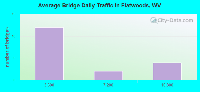
- 54,104Total average daily traffic
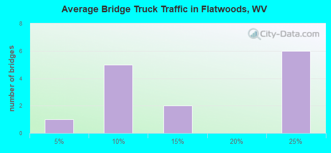
- 10,950Total average daily truck traffic
- National Bridge Inventory (NBI) Registered Bridges for Flatwoods
- No street view available for this location
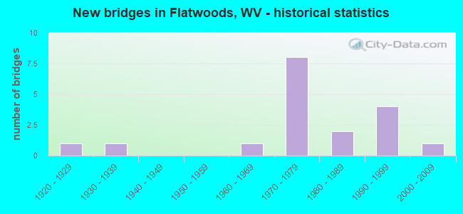
- New bridges - historical statistics
- 11920-1929
- 11930-1939
- 11960-1969
- 81970-1979
- 21980-1989
- 41990-1999
- 12000-2009
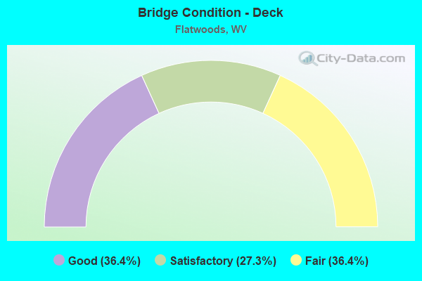
- Bridge Condition - Deck
- 36.4%Good
- 27.3%Satisfactory
- 36.4%Fair
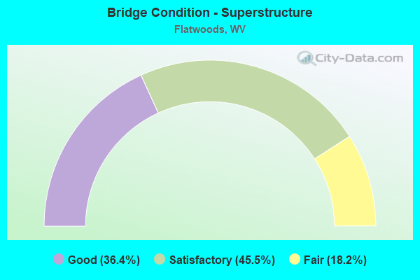
- Bridge Condition - Superstructure
- 36.4%Good
- 45.5%Satisfactory
- 18.2%Fair
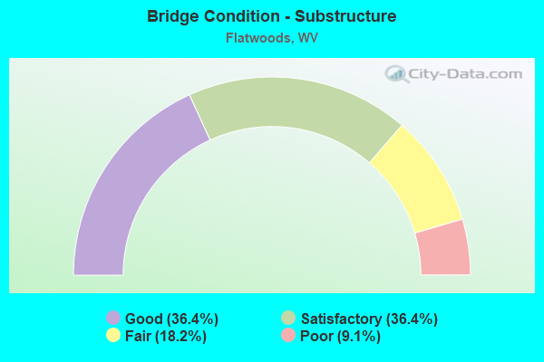
- Bridge Condition - Substructure
- 36.4%Good
- 36.4%Satisfactory
- 18.2%Fair
- 9.1%Poor
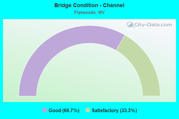
- Bridge Condition - Channel
- 66.7%Good
- 33.3%Satisfactory
Find on map >> Show street view
Structure Number: 4A045, Location: 0.01 MI S CO 10 (Lat: 38.769650, Lng: -80.693200), Route carried "on" structure: County highway 1004, Year Built: 1995, Status: Open, Structure Length: 0.84m (2.76ft), Average Daily Traffic: 226 (year 2015), Average Future Daily Traffic: 323 (year 2035), Design Load: HS 25 or greater, Features Intersected: CEDAR CREEK, Facility Carried by Structure: COUNTY ROUTE 10/4
Minimum Vertical Clearance: 30+ m (98+ ft), Kilometerpoint: 7.306, Lanes on structure: 1, Owner: State Highway Agency, Approaching Roadway Width: 4.3m (14.1ft), Material/Design: Steel, Design/Construction: Stringer/Multi-beam, Number Of Spans In Main Unit: 1, Length of Maximum Span: 7.8m (25.6ft), Curb or Sidewalk Widths: Left: 0.2m (0.7ft), Right: 0.2m (0.7ft), Curb-To-Curb Width: 4.3m (14.1ft), Out-to-Out Width: 4.3m (14.1ft)
Condition: Deck: Satisfactory, Superstructure: Satisfactory, Substructure: Satisfactory, Channel: Good, Operating Rating: 88.9 metric tons, Method Used To Determine Operating Rating: Load Factor (LF), Inventory Rating: 71.7 metric tons, Method Used To Determine Inventory Rating: Load Factor (LF), Structural Evaluation: Equal to present minimum criteria, Deck Geometry: High priority of replacement, Waterway Adequacy: Meets minimum limits, Approach Roadway Alignment: Equal to present desirable criteria, Designated Inspection Frequency: Every 48 months, Inspection Date: Febuary 2020, Deck Structure Type: Wood or Timber, Wearing Surface/Protective System: Wearing Surface: Bituminous
Find on map >> Show street view
Structure Number: 4A059, Location: 0.13 MI N OF WV 5 (Lat: 38.762100, Lng: -80.637150), Route carried "on" structure: US 1900, Year Built: 1927, Status: Open, Structure Length: 0.98m (3.22ft), Average Daily Traffic: 1,500 (year 2018), Truck Traffic: 23%, Average Future Daily Traffic: 2,070 (year 2038), Features Intersected: BERRY FORK, Facility Carried by Structure: US 19
Minimum Vertical Clearance: 30+ m (98+ ft), Kilometerpoint: 35.035, Lanes on structure: 2, Owner: State Highway Agency, Approaching Roadway Width: 9.8m (32.2ft), Skew: 3 degrees, Material/Design: Concrete, Design/Construction: Slab, Number Of Spans In Main Unit: 1, Length of Maximum Span: 9.1m (29.9ft), Curb-To-Curb Width: 9.1m (29.9ft), Out-to-Out Width: 10.0m (32.8ft)
Condition: Deck: Fair, Superstructure: Fair, Substructure: Fair, Channel: Satisfactory, Operating Rating: 63.5 metric tons, Method Used To Determine Operating Rating: Field evaluation and documented engineering judgment, Inventory Rating: 29.0 metric tons, Method Used To Determine Inventory Rating: Field evaluation and documented engineering judgment, Structural Evaluation: Somewhat better than minimum adequacy, Deck Geometry: Somewhat better than minimum adequacy, Waterway Adequacy: Superior to present desirable criteria, Approach Roadway Alignment: Equal to present desirable criteria, Length Of Structure Improvement: 1.62m (5.31ft), Designated Inspection Frequency: Every 24 months, Inspection Date: January 2021, Bridge Improvement Cost: $248,000, Roadway Improvement Cost: $246,000, Total Project Cost: $646,000 ( Estimate for 2021), Deck Structure Type: Concrete Cast-file-Place, Wearing Surface/Protective System: Wearing Surface: Bituminous
Find on map >> Show street view
Structure Number: 4A06, Location: 0.02 MI S OF CO 22 (Lat: 38.768639, Lng: -80.616200), Route carried "on" structure: US 1900, Year Built: 1986, Status: Posted for load, Structure Length: 2.18m (7.15ft), Average Daily Traffic: 1,500 (year 2018), Truck Traffic: 23%, Average Future Daily Traffic: 2,070 (year 2038), Design Load: HS 20, Features Intersected: SALTLICK CREEK, Facility Carried by Structure: US 19
Minimum Vertical Clearance: 30+ m (98+ ft), Kilometerpoint: 37.321, Lanes on structure: 2, Owner: State Highway Agency, Approaching Roadway Width: 7.9m (25.9ft), Material/Design: Prestressed concrete, Design/Construction: Box Beam or Girders - Multiple, Number Of Spans In Main Unit: 1, Length of Maximum Span: 21.3m (69.9ft), Curb-To-Curb Width: 8.0m (26.2ft), Out-to-Out Width: 8.2m (26.9ft)
Condition: Deck: Fair, Superstructure: Fair, Substructure: Good, Channel: Satisfactory, Operating Rating: 26.3 metric tons, Method Used To Determine Operating Rating: Load and Resistance Factor (LRFR), Inventory Rating: 20.9 metric tons, Method Used To Determine Inventory Rating: Load and Resistance Factor (LRFR), Structural Evaluation: Somewhat better than minimum adequacy, Deck Geometry: Meets minimum limits, Waterway Adequacy: Superior to present desirable criteria, Approach Roadway Alignment: Equal to present desirable criteria, Bridge Posting: Required (Relationship of Operating Rating to Maximum Legal Load: 0.1 - 9.9% below), Length Of Structure Improvement: 2.19m (7.19ft), Designated Inspection Frequency: Every 24 months, Inspection Date: March 2021, Bridge Improvement Cost: $200,000, Roadway Improvement Cost: $20,000, Total Project Cost: $250,000 ( Estimate for 2021), Deck Structure Type: Other, Wearing Surface/Protective System: Deck Protection: Epoxy Coated Reinforcing
Find on map >> Show street view
Structure Number: 4A075, Location: 0.02 MI N US 19 (Lat: 38.762289, Lng: -80.641700), Route carried "on" structure: County highway 1946, Year Built: 1968, Year Reconstructed: 2020, Status: Open, Structure Length: 0.95m (3.12ft), Average Daily Traffic: 33 (year 2015), Truck Traffic: 6%, Average Future Daily Traffic: 47 (year 2035), Features Intersected: RT FK OF SALTLICK, Facility Carried by Structure: COUNTY ROUTE 19/46
Minimum Vertical Clearance: 30+ m (98+ ft), Kilometerpoint: 0.032, Lanes on structure: 1, Owner: State Highway Agency, Approaching Roadway Width: 4.9m (16.1ft), Material/Design: Steel, Design/Construction: Stringer/Multi-beam, Number Of Spans In Main Unit: 1, Length of Maximum Span: 8.8m (28.9ft), Curb or Sidewalk Widths: Left: 0.2m (0.7ft), Right: 0.2m (0.7ft), Curb-To-Curb Width: 4.6m (15.1ft), Out-to-Out Width: 4.8m (15.7ft)
Condition: Deck: Good, Superstructure: Good, Substructure: Satisfactory, Channel: Good, Operating Rating: 39.0 metric tons, Method Used To Determine Operating Rating: Load and Resistance Factor (LRFR), Inventory Rating: 29.9 metric tons, Method Used To Determine Inventory Rating: Load and Resistance Factor (LRFR), Structural Evaluation: Equal to present minimum criteria, Deck Geometry: Better than present minimum criteria, Waterway Adequacy: Better than present minimum criteria, Approach Roadway Alignment: Equal to present desirable criteria, Length Of Structure Improvement: 1.52m (4.99ft), Designated Inspection Frequency: Every 24 months, Inspection Date: April 2020, Bridge Improvement Cost: $147,000, Roadway Improvement Cost: $70,000, Total Project Cost: $268,000 ( Estimate for 2018), Deck Structure Type: Wood or Timber, Wearing Surface/Protective System: Wearing Surface: Bituminous
Find on map >> Show street view
Structure Number: 4A082, Location: 0.01 MI S OF CO 22/6 (Lat: 38.736761, Lng: -80.599089), Route carried "on" structure: County highway 2200, Year Built: 1986, Status: Open, Structure Length: 1.82m (5.97ft), Average Daily Traffic: 100 (year 2018), Truck Traffic: 6%, Average Future Daily Traffic: 138 (year 2038), Design Load: HS 20, Features Intersected: SALTLICK CREEK, Facility Carried by Structure: COUNTY ROUTE 22
Minimum Vertical Clearance: 30+ m (98+ ft), Kilometerpoint: 5.665, Lanes on structure: 2, Owner: State Highway Agency, Approaching Roadway Width: 4.3m (14.1ft), Skew: 1 degrees, Material/Design: Prestressed concrete, Design/Construction: Box Beam or Girders - Multiple, Number Of Spans In Main Unit: 1, Length of Maximum Span: 17.2m (56.4ft), Curb-To-Curb Width: 6.1m (20.0ft), Out-to-Out Width: 6.4m (21.0ft)
Condition: Deck: Satisfactory, Superstructure: Satisfactory, Substructure: Poor, Channel: Satisfactory, Operating Rating: 60.8 metric tons, Method Used To Determine Operating Rating: Load and Resistance Factor (LRFR), Inventory Rating: 46.3 metric tons, Method Used To Determine Inventory Rating: Load and Resistance Factor (LRFR), Structural Evaluation: Meets minimum limits, Deck Geometry: Somewhat better than minimum adequacy, Waterway Adequacy: Superior to present desirable criteria, Approach Roadway Alignment: Equal to present minimum criteria, Length Of Structure Improvement: 2.29m (7.51ft), Designated Inspection Frequency: Every 24 months, Inspection Date: Febuary 2021, Bridge Improvement Cost: $250,000, Roadway Improvement Cost: $50,000, Total Project Cost: $350,000 ( Estimate for 2021), Deck Structure Type: Other, Wearing Surface/Protective System: Deck Protection: Epoxy Coated Reinforcing
Find on map >> Show street view
Structure Number: 4A117, Location: 0.55 MI S OF CO 19/22 (Lat: 38.696869, Lng: -80.668850), Route carried "on" structure: Interstate 7900, Year Built: 1972, Status: Open, Structure Length: 0.62m (2.03ft), Average Daily Traffic: 9,700 (year 2018), Truck Traffic: 23%, Average Future Daily Traffic: 13,871 (year 2038), Design Load: HS 20+Mod, Features Intersected: CR 4/22, Facility Carried by Structure: I79 X
Minimum Vertical Clearance: 30+ m (98+ ft), Kilometerpoint: 106.973, Lanes on structure: 2, Lanes under structure: 1, Base Highway Network: Yes, Owner: State Highway Agency, Approaching Roadway Width: 14.0m (45.9ft), Material/Design: Steel, Design/Construction: Culvert, Number Of Spans In Main Unit: 1, Length of Maximum Span: 6.2m (20.3ft)
Condition: Culverts: Fair, Operating Rating: 71.7 metric tons, Method Used To Determine Operating Rating: Field evaluation and documented engineering judgment, Inventory Rating: 32.7 metric tons, Method Used To Determine Inventory Rating: Field evaluation and documented engineering judgment, Structural Evaluation: Somewhat better than minimum adequacy, Underclear: High priority of corrective action, Approach Roadway Alignment: Superior to present desirable criteria, Length Of Structure Improvement: 0.64m (2.10ft), Designated Inspection Frequency: Every 24 months, Inspection Date: October 2021, Bridge Improvement Cost: $40,000, Roadway Improvement Cost: $10,000, Total Project Cost: $60,000 ( Estimate for 2022)
Find on map >> Show street view
Structure Number: 4A118, Location: 0.55 MI S OF CO 19/22 (Lat: 38.697161, Lng: -80.669250), Route carried "on" structure: Interstate 7900, Year Built: 1972, Status: Open, Structure Length: 0.62m (2.03ft), Average Daily Traffic: 9,700 (year 2018), Truck Traffic: 23%, Average Future Daily Traffic: 13,871 (year 2038), Design Load: HS 20+Mod, Features Intersected: CR 4/22, Facility Carried by Structure: I79 X
Minimum Vertical Clearance: 30+ m (98+ ft), Kilometerpoint: 106.973, Lanes on structure: 2, Lanes under structure: 1, Base Highway Network: Yes, Owner: State Highway Agency, Approaching Roadway Width: 14.0m (45.9ft), Material/Design: Steel, Design/Construction: Culvert, Number Of Spans In Main Unit: 1, Length of Maximum Span: 6.2m (20.3ft)
Condition: Culverts: Fair, Operating Rating: 71.7 metric tons, Method Used To Determine Operating Rating: Field evaluation and documented engineering judgment, Inventory Rating: 32.7 metric tons, Method Used To Determine Inventory Rating: Field evaluation and documented engineering judgment, Structural Evaluation: Somewhat better than minimum adequacy, Underclear: High priority of corrective action, Approach Roadway Alignment: Superior to present desirable criteria, Length Of Structure Improvement: 0.64m (2.10ft), Designated Inspection Frequency: Every 24 months, Inspection Date: October 2021, Bridge Improvement Cost: $40,000, Roadway Improvement Cost: $10,000, Total Project Cost: $60,000 ( Estimate for 2022)
Find on map >> Show street view
Structure Number: 4A119, Location: 5.56 MI N WV 4 (Lat: 38.703111, Lng: -80.663000), Route carried "on" structure: Interstate 7900, Year Built: 1972, Status: Open, Structure Length: 4.01m (13.16ft), Average Daily Traffic: 9,700 (year 2018), Truck Traffic: 24%, Average Future Daily Traffic: 13,871 (year 2038), Design Load: HS 20+Mod, Features Intersected: CR 19/22, Facility Carried by Structure: I-79 N
Minimum Vertical Clearance: 30+ m (98+ ft), Kilometerpoint: 107.842, Lanes on structure: 2, Lanes under structure: 2, Base Highway Network: Yes, Owner: State Highway Agency, Approaching Roadway Width: 14.0m (45.9ft), Material/Design: Steel continuous, Design/Construction: Stringer/Multi-beam, Number Of Spans In Main Unit: 1, Number Of Approach Spans: 2, Length of Maximum Span: 16.2m (53.1ft), Curb-To-Curb Width: 12.3m (40.4ft), Out-to-Out Width: 13.6m (44.6ft)
Condition: Deck: Fair, Superstructure: Satisfactory, Substructure: Fair, Operating Rating: 54.4 metric tons, Method Used To Determine Operating Rating: Load Factor (LF), Inventory Rating: 32.7 metric tons, Method Used To Determine Inventory Rating: Load Factor (LF), Structural Evaluation: Somewhat better than minimum adequacy, Deck Geometry: Better than present minimum criteria, Underclear: Equal to present minimum criteria, Approach Roadway Alignment: Equal to present desirable criteria, Length Of Structure Improvement: 4.02m (13.19ft), Designated Inspection Frequency: Every 24 months, Inspection Date: December 2021, Bridge Improvement Cost: $200,000, Roadway Improvement Cost: $10,000, Total Project Cost: $264,000 ( Estimate for 2022), Deck Structure Type: Concrete Cast-file-Place, Wearing Surface/Protective System: Wearing Surface: Latex Concrete
Find on map >> Show street view
Structure Number: 4A12, Location: 5.56 MI N WV 4 (Lat: 38.703269, Lng: -80.663219), Route carried "on" structure: Interstate 7900, Year Built: 1972, Status: Open, Structure Length: 4.01m (13.16ft), Average Daily Traffic: 9,700 (year 2018), Truck Traffic: 24%, Average Future Daily Traffic: 13,871 (year 2038), Design Load: HS 20+Mod, Features Intersected: CR 19/22, Facility Carried by Structure: I-79 S
Minimum Vertical Clearance: 30+ m (98+ ft), Kilometerpoint: 107.842, Lanes on structure: 2, Lanes under structure: 2, Base Highway Network: Yes, Owner: State Highway Agency, Approaching Roadway Width: 14.0m (45.9ft), Material/Design: Steel continuous, Design/Construction: Stringer/Multi-beam, Number Of Spans In Main Unit: 1, Number Of Approach Spans: 2, Length of Maximum Span: 16.2m (53.1ft), Curb-To-Curb Width: 12.3m (40.4ft), Out-to-Out Width: 13.6m (44.6ft)
Condition: Deck: Fair, Superstructure: Satisfactory, Substructure: Satisfactory, Operating Rating: 54.4 metric tons, Method Used To Determine Operating Rating: Load Factor (LF), Inventory Rating: 32.7 metric tons, Method Used To Determine Inventory Rating: Load Factor (LF), Structural Evaluation: Equal to present minimum criteria, Deck Geometry: Better than present minimum criteria, Underclear: Equal to present minimum criteria, Approach Roadway Alignment: Equal to present desirable criteria, Length Of Structure Improvement: 4.02m (13.19ft), Designated Inspection Frequency: Every 24 months, Inspection Date: December 2021, Bridge Improvement Cost: $200,000, Roadway Improvement Cost: $10,000, Total Project Cost: $264,000 ( Estimate for 2022), Deck Structure Type: Concrete Cast-file-Place, Wearing Surface/Protective System: Wearing Surface: Latex Concrete
Find on map >> Show street view
Structure Number: 4A135, Location: 0.01 MI E WV 5 (Lat: 38.774100, Lng: -80.638831), Route carried "on" structure: County highway 514, Year Built: 1995, Status: Posted for load, Structure Length: 1.42m (4.66ft), Average Daily Traffic: 20 (year 2018), Truck Traffic: 8%, Average Future Daily Traffic: 21 (year 2038), Design Load: HS 25 or greater, Features Intersected: RIGHT FORK SALTLICK CK, Facility Carried by Structure: COUNTY ROUTE 5/14
Minimum Vertical Clearance: 30+ m (98+ ft), Kilometerpoint: 0.016, Lanes on structure: 1, Owner: State Highway Agency, Approaching Roadway Width: 5.5m (18.0ft), Material/Design: Wood or Timber, Design/Construction: Box Beam or Girders - Multiple, Number Of Spans In Main Unit: 1, Length of Maximum Span: 13.1m (43.0ft), Curb or Sidewalk Widths: Left: 0.2m (0.7ft), Right: 0.2m (0.7ft), Curb-To-Curb Width: 4.7m (15.4ft), Out-to-Out Width: 5.2m (17.1ft)
Condition: Deck: Good, Superstructure: Good, Substructure: Good, Channel: Good, Operating Rating: 37.2 metric tons, Method Used To Determine Operating Rating: Allowable Stress (AS), Inventory Rating: 23.6 metric tons, Method Used To Determine Inventory Rating: Allowable Stress (AS), Structural Evaluation: Equal to present minimum criteria, Deck Geometry: Better than present minimum criteria, Waterway Adequacy: Superior to present desirable criteria, Approach Roadway Alignment: Equal to present minimum criteria, Bridge Posting: Required (Relationship of Operating Rating to Maximum Legal Load: 10.0 - 19.9% below), Designated Inspection Frequency: Every 24 months, Other Special Inspection Frequency: Every 12 months, Inspection Date: June 2021, Other Special Inspection Date: June 2021, Deck Structure Type: Wood or Timber, Wearing Surface/Protective System: Wearing Surface: Bituminous
Find on map >> Show street view
Structure Number: 4A167, Location: 0.05 W US 19 F (Lat: 38.762919, Lng: -80.639561), Route carried "on" structure: State highway 500, Year Built: 1998, Status: Open, Structure Length: 1.07m (3.51ft), Average Daily Traffic: 500 (year 2018), Truck Traffic: 4%, Average Future Daily Traffic: 690 (year 2038), Design Load: HS 25 or greater, Features Intersected: BERRY FORK, Facility Carried by Structure: WV 5
Minimum Vertical Clearance: 30+ m (98+ ft), Kilometerpoint: 20.905, Lanes on structure: 2, Owner: State Highway Agency, Approaching Roadway Width: 7.9m (25.9ft), Material/Design: Prestressed concrete, Design/Construction: Box Beam or Girders - Multiple, Number Of Spans In Main Unit: 1, Length of Maximum Span: 9.9m (32.5ft), Curb-To-Curb Width: 7.8m (25.6ft), Out-to-Out Width: 8.3m (27.2ft)
Condition: Deck: Good, Superstructure: Good, Substructure: Good, Channel: Good, Operating Rating: 81.6 metric tons, Method Used To Determine Operating Rating: Load and Resistance Factor (LRFR), Inventory Rating: 62.6 metric tons, Method Used To Determine Inventory Rating: Load and Resistance Factor (LRFR), Structural Evaluation: Better than present minimum criteria, Deck Geometry: Meets minimum limits, Waterway Adequacy: Meets minimum limits, Approach Roadway Alignment: Equal to present desirable criteria, Designated Inspection Frequency: Every 48 months, Inspection Date: November 2020, Deck Structure Type: Concrete Cast-file-Place, Wearing Surface/Protective System: Wearing Surface: Bituminous, Deck Protection: Epoxy Coated Reinforcing
Find on map >> Show street view
Structure Number: 4A172, Location: 0.71 MI W OF US 19 (Lat: 38.770481, Lng: -80.639439), Route carried "on" structure: State highway 500, Year Built: 1999, Status: Open, Structure Length: 1.25m (4.10ft), Average Daily Traffic: 475 (year 2015), Truck Traffic: 6%, Average Future Daily Traffic: 635 (year 2035), Design Load: HS 25 or greater, Features Intersected: O'BRIEN FK SALTLICK CK, Facility Carried by Structure: WV 5
Minimum Vertical Clearance: 30+ m (98+ ft), Kilometerpoint: 19.843, Lanes on structure: 2, Owner: State Highway Agency, Approaching Roadway Width: 7.6m (24.9ft), Skew: 3 degrees, Material/Design: Prestressed concrete, Design/Construction: Box Beam or Girders - Multiple, Number Of Spans In Main Unit: 1, Length of Maximum Span: 11.6m (38.1ft), Curb-To-Curb Width: 8.7m (28.5ft), Out-to-Out Width: 9.2m (30.2ft)
Condition: Deck: Good, Superstructure: Good, Substructure: Satisfactory, Channel: Good, Operating Rating: 83.4 metric tons, Method Used To Determine Operating Rating: Load and Resistance Factor (LRFR), Inventory Rating: 64.4 metric tons, Method Used To Determine Inventory Rating: Load and Resistance Factor (LRFR), Structural Evaluation: Equal to present minimum criteria, Deck Geometry: Somewhat better than minimum adequacy, Waterway Adequacy: Superior to present desirable criteria, Approach Roadway Alignment: Equal to present desirable criteria, Designated Inspection Frequency: Every 48 months, Inspection Date: June 2019, Deck Structure Type: Concrete Cast-file-Place, Wearing Surface/Protective System: Wearing Surface: Bituminous, Deck Protection: Epoxy Coated Reinforcing
Find on map >> Show street view
Structure Number: 4A19, Location: 0.19 MI N OF CO 22/6 (Lat: 38.739511, Lng: -80.599281), Route carried "on" structure: County highway 2200, Year Built: 2009, Status: Open, Structure Length: 2.60m (8.53ft), Average Daily Traffic: 100 (year 2015), Truck Traffic: 6%, Average Future Daily Traffic: 138 (year 2035), Design Load: HL 93, Features Intersected: SALTLICK CREEK, Facility Carried by Structure: COUNTY ROUTE 22
Minimum Vertical Clearance: 30+ m (98+ ft), Kilometerpoint: 5.343, Lanes on structure: 2, Owner: State Highway Agency, Approaching Roadway Width: 4.9m (16.1ft), Skew: 3 degrees, Material/Design: Prestressed concrete, Design/Construction: Box Beam or Girders - Multiple, Number Of Spans In Main Unit: 1, Length of Maximum Span: 24.4m (80.1ft), Curb-To-Curb Width: 7.3m (24.0ft), Out-to-Out Width: 7.4m (24.3ft)
Condition: Deck: Satisfactory, Superstructure: Satisfactory, Substructure: Good, Channel: Good, Operating Rating: 70.7 metric tons, Method Used To Determine Operating Rating: Load and Resistance Factor (LRFR), Inventory Rating: 54.4 metric tons, Method Used To Determine Inventory Rating: Load and Resistance Factor (LRFR), Structural Evaluation: Equal to present minimum criteria, Deck Geometry: Equal to present minimum criteria, Waterway Adequacy: Superior to present desirable criteria, Approach Roadway Alignment: Equal to present desirable criteria, Designated Inspection Frequency: Every 48 months, Inspection Date: April 2020, Deck Structure Type: Other, Wearing Surface/Protective System: Wearing Surface: Bituminous, Deck Protection: Epoxy Coated Reinforcing
Find on map >> Show street view
Structure Number: 4A117, Location: 0.55 MI S OF CO 19/22 (Lat: 38.696869, Lng: -80.668850), Route carried "under" structure: County highway 422, Year Built: 1972, Structure Length: 0. m, Average Daily Traffic: 10 (year 0009), Features Intersected: CR 4/22, Facility Carried by Structure: I79 X
Minimum Vertical Clearance: 4.17m (13.68ft), Kilometerpoint: 0.064, Lanes on structure: 2, Lanes under structure: 1, Length of Maximum Span: 6.2m (20.3ft)
Find on map >> Show street view
Structure Number: 4A118, Location: 0.55 MI S OF CO 19/22 (Lat: 38.697161, Lng: -80.669250), Route carried "under" structure: County highway 422, Year Built: 1972, Structure Length: 0. m, Average Daily Traffic: 10 (year 0009), Features Intersected: CR 4/22, Facility Carried by Structure: I79 X
Minimum Vertical Clearance: 4.17m (13.68ft), Kilometerpoint: 0.113, Lanes on structure: 2, Lanes under structure: 1, Length of Maximum Span: 6.2m (20.3ft)
Find on map >> Show street view
Structure Number: 4A119, Location: 5.56 MI N WV 4 (Lat: 38.703111, Lng: -80.663000), Route carried "under" structure: County highway 1922, Year Built: 1972, Structure Length: 0. m, Average Daily Traffic: 5,400 (year 0009), Truck Traffic: 10%, Features Intersected: CR 19/22, Facility Carried by Structure: I-79 N
Minimum Vertical Clearance: 5.51m (18.08ft), Kilometerpoint: 3.524, Lanes on structure: 2, Lanes under structure: 2, Length of Maximum Span: 16.2m (53.1ft)
Find on map >> Show street view
Structure Number: 4A12, Location: 5.56 MI N WV 4 (Lat: 38.703269, Lng: -80.663200), Route carried "under" structure: County highway 1922, Year Built: 1972, Structure Length: 0. m, Average Daily Traffic: 5,400 (year 0006), Truck Traffic: 10%, Features Intersected: CR 19/22, Facility Carried by Structure: I-79 S
Minimum Vertical Clearance: 4.90m (16.08ft), Kilometerpoint: 3.508, Lanes on structure: 2, Lanes under structure: 2, Length of Maximum Span: 16.2m (53.1ft)
Find on map >> Show street view
Structure Number: 4A152, Location: 1.66 MI E OF US 19 (Lat: 38.706600, Lng: -80.632389), Route carried "under" structure: County highway 1921, Year Built: 1936, Structure Length: 0. m, Average Daily Traffic: 30 (year 2015), Features Intersected: A&O RAILROAD, Facility Carried by Structure: Business Other road 8
Minimum Vertical Clearance: 9.91m (32.51ft), Kilometerpoint: 2.672, Lanes under structure: 1, Material/Design: Steel, Design/Construction: Stringer/Multi-beam, Length of Maximum Span: 18.3m (60.0ft)