Bridge Statistics for Forkland, Alabama (AL)
Condition, Traffic, Stress, Structural Evaluation, Project Costs
- National Bridge Inventory (NBI) Statistics
- 18Number of bridges
- 148ft / 44.8mTotal length
- $21,235,000Total costs
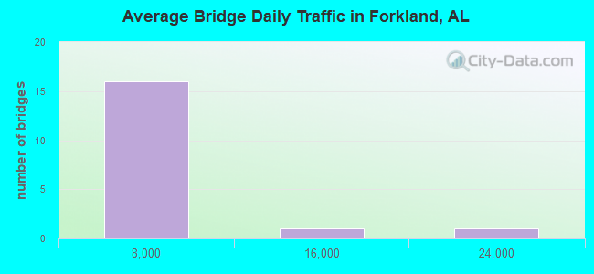
- 61,158Total average daily traffic
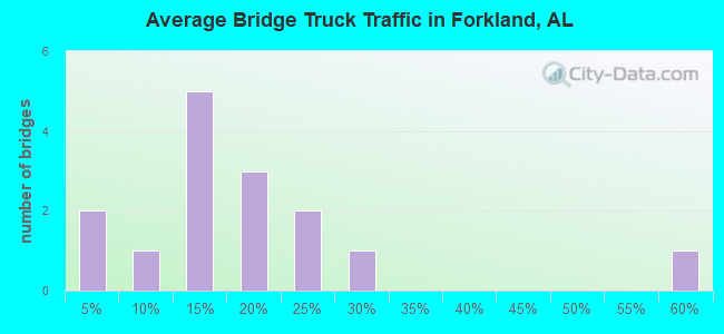
- 7,575Total average daily truck traffic
- 84,446Total future (year 2031) average daily traffic
- National Bridge Inventory (NBI) Registered Bridges for Forkland
- No street view available for this location
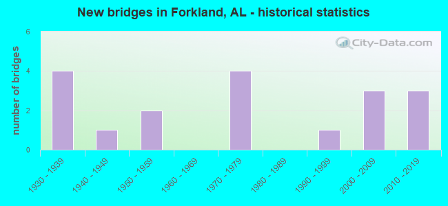
- New bridges - historical statistics
- 41930-1939
- 11940-1949
- 21950-1959
- 41970-1979
- 11990-1999
- 32000-2009
- 32010-2019
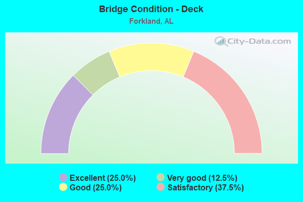
- Bridge Condition - Deck
- 25.0%Excellent
- 12.5%Very good
- 25.0%Good
- 37.5%Satisfactory
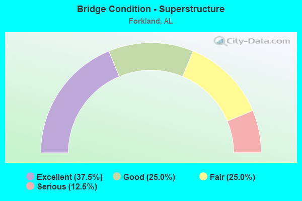
- Bridge Condition - Superstructure
- 37.5%Excellent
- 25.0%Good
- 25.0%Fair
- 12.5%Serious
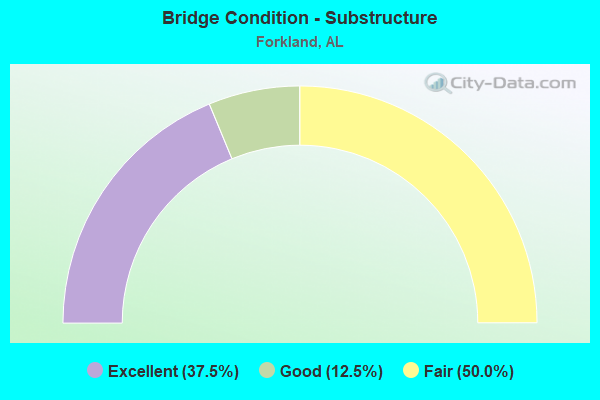
- Bridge Condition - Substructure
- 37.5%Excellent
- 12.5%Good
- 50.0%Fair
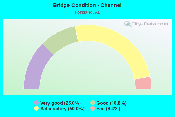
- Bridge Condition - Channel
- 25.0%Very good
- 18.8%Good
- 50.0%Satisfactory
- 6.3%Fair
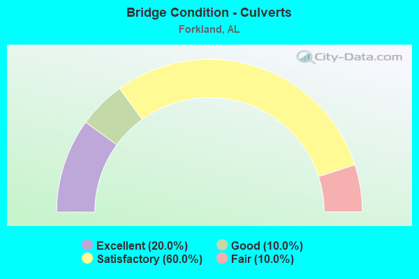
- Bridge Condition - Culverts
- 20.0%Excellent
- 10.0%Good
- 60.0%Satisfactory
- 10.0%Fair
Find on map >> Show street view
Structure Number: 762, Location: 0.5 MI W HWY 43 (Lat: 32.645000, Lng: -87.878333), Route carried "on" structure: County highway 19, Year Built: 1930, Status: Posted for load, Structure Length: 0.67m (2.20ft), Average Daily Traffic: 572 (year 1995), Truck Traffic: 55%, Average Future Daily Traffic: 660 (year 2031), Features Intersected: CREEK, Facility Carried by Structure: CO RD 20
Minimum Vertical Clearance: 30+ m (98+ ft), Kilometerpoint: 0.010, Lanes on structure: 2, Owner: County Highway Agency, Approaching Roadway Width: 7.9m (25.9ft), Material/Design: Concrete, Design/Construction: Culvert, Number Of Spans In Main Unit: 2, Length of Maximum Span: 3.4m (11.2ft)
Condition: Channel: Satisfactory, Culverts: Fair, Operating Rating: 13.6 metric tons, Method Used To Determine Operating Rating: Field evaluation and documented engineering judgment, Inventory Rating: 10.0 metric tons, Method Used To Determine Inventory Rating: Field evaluation and documented engineering judgment, Structural Evaluation: High priority of replacement, Waterway Adequacy: Somewhat better than minimum adequacy, Approach Roadway Alignment: Better than present minimum criteria, Bridge Posting: Required (Relationship of Operating Rating to Maximum Legal Load: > 39.9% below), Length Of Structure Improvement: 1.30m (4.27ft), Designated Inspection Frequency: Every 24 months, Other Special Inspection Frequency: Every 12 months, Inspection Date: April 2020, Other Special Inspection Date: May 2021, Bridge Improvement Cost: $165,000, Roadway Improvement Cost: $17,000, Total Project Cost: $182,000 ( Estimate for 2022), Wearing Surface/Protective System: Wearing Surface: Bituminous
Find on map >> Show street view
Structure Number: 3159, Location: 2.5 MI S FORKLAND (Lat: 32.630817, Lng: -87.848467), Route carried "on" structure: US 43, Year Built: 1931, Year Reconstructed: 1948, Status: Open, Structure Length: 0.64m (2.10ft), Average Daily Traffic: 3,740 (year 2013), Truck Traffic: 13%, Average Future Daily Traffic: 4,804 (year 2040), Design Load: H 15, Features Intersected: 12 Mile Bend Slough
Minimum Vertical Clearance: 30+ m (98+ ft), Kilometerpoint: 232.647, Lanes on structure: 2, Base Highway Network: Yes, Owner: State Highway Agency, Approaching Roadway Width: 9.4m (30.8ft), Material/Design: Concrete, Design/Construction: Culvert, Number Of Spans In Main Unit: 2, Length of Maximum Span: 3.0m (9.8ft)
Condition: Channel: Good, Culverts: Satisfactory, Operating Rating: 52.2 metric tons, Method Used To Determine Operating Rating: Load Factor (LF), Inventory Rating: 31.3 metric tons, Method Used To Determine Inventory Rating: Load Factor (LF), Structural Evaluation: Equal to present minimum criteria, Waterway Adequacy: Equal to present minimum criteria, Approach Roadway Alignment: Equal to present desirable criteria, Length Of Structure Improvement: 1.26m (4.13ft), Designated Inspection Frequency: Every 24 months, Inspection Date: June 2020, Bridge Improvement Cost: $364,000, Roadway Improvement Cost: $36,000, Total Project Cost: $400,000 ( Estimate for 2022)
Find on map >> Show street view
Structure Number: 316, Location: 1.5 MI S FORKLAND (Lat: 32.638483, Lng: -87.859767), Route carried "on" structure: US 43, Year Built: 1931, Year Reconstructed: 1948, Status: Open, Structure Length: 0.73m (2.40ft), Average Daily Traffic: 3,740 (year 2013), Truck Traffic: 13%, Average Future Daily Traffic: 4,804 (year 2040), Design Load: H 15, Features Intersected: 12 Mile Bend Creek
Minimum Vertical Clearance: 30+ m (98+ ft), Kilometerpoint: 234.028, Lanes on structure: 2, Base Highway Network: Yes, Owner: State Highway Agency, Approaching Roadway Width: 9.4m (30.8ft), Skew: 4 degrees, Material/Design: Concrete, Design/Construction: Culvert, Number Of Spans In Main Unit: 2, Length of Maximum Span: 3.4m (11.2ft)
Condition: Channel: Satisfactory, Culverts: Satisfactory, Operating Rating: 81.1 metric tons, Method Used To Determine Operating Rating: Load Factor (LF), Inventory Rating: 48.6 metric tons, Method Used To Determine Inventory Rating: Load Factor (LF), Structural Evaluation: Equal to present minimum criteria, Waterway Adequacy: Equal to present minimum criteria, Approach Roadway Alignment: Equal to present desirable criteria, Length Of Structure Improvement: 1.38m (4.53ft), Designated Inspection Frequency: Every 24 months, Inspection Date: June 2020, Bridge Improvement Cost: $421,000, Roadway Improvement Cost: $42,000, Total Project Cost: $463,000 ( Estimate for 2022)
Find on map >> Show street view
Structure Number: 3161, Location: 2.0 MI N FORKLAND (Lat: 32.679450, Lng: -87.899433), Route carried "on" structure: US 43, Year Built: 1931, Year Reconstructed: 1948, Status: Open, Structure Length: 0.98m (3.22ft), Average Daily Traffic: 2,930 (year 2016), Truck Traffic: 17%, Average Future Daily Traffic: 3,764 (year 2040), Design Load: H 15, Features Intersected: UT to Needham Creek
Minimum Vertical Clearance: 30+ m (98+ ft), Kilometerpoint: 240.166, Lanes on structure: 2, Base Highway Network: Yes, Owner: State Highway Agency, Approaching Roadway Width: 10.4m (34.1ft), Skew: 1 degrees, Material/Design: Concrete, Design/Construction: Culvert, Number Of Spans In Main Unit: 3, Length of Maximum Span: 3.2m (10.5ft)
Condition: Channel: Good, Culverts: Satisfactory, Operating Rating: 79.4 metric tons, Method Used To Determine Operating Rating: Load Factor (LF), Inventory Rating: 47.6 metric tons, Method Used To Determine Inventory Rating: Load Factor (LF), Structural Evaluation: Equal to present minimum criteria, Waterway Adequacy: Equal to present minimum criteria, Approach Roadway Alignment: Equal to present desirable criteria, Length Of Structure Improvement: 1.64m (5.38ft), Designated Inspection Frequency: Every 24 months, Inspection Date: July 2020, Bridge Improvement Cost: $503,000, Roadway Improvement Cost: $50,000, Total Project Cost: $553,000 ( Estimate for 2022)
Find on map >> Show street view
Structure Number: 3205, Location: FORKLAND (Lat: 32.649750, Lng: -87.879550), Route carried "on" structure: US 43, Year Built: 1948, Status: Open, Structure Length: 0.64m (2.10ft), Average Daily Traffic: 3,740 (year 2013), Truck Traffic: 13%, Average Future Daily Traffic: 4,804 (year 2040), Design Load: H 15, Features Intersected: Taylor Branch
Minimum Vertical Clearance: 30+ m (98+ ft), Kilometerpoint: 236.303, Lanes on structure: 2, Base Highway Network: Yes, Owner: State Highway Agency, Approaching Roadway Width: 9.8m (32.2ft), Material/Design: Concrete, Design/Construction: Culvert, Number Of Spans In Main Unit: 2, Length of Maximum Span: 3.0m (9.8ft)
Condition: Channel: Satisfactory, Culverts: Satisfactory, Operating Rating: 88.9 metric tons, Method Used To Determine Operating Rating: Load Factor (LF), Inventory Rating: 67.5 metric tons, Method Used To Determine Inventory Rating: Load Factor (LF), Structural Evaluation: Equal to present minimum criteria, Waterway Adequacy: Equal to present minimum criteria, Approach Roadway Alignment: Equal to present desirable criteria, Length Of Structure Improvement: 1.26m (4.13ft), Designated Inspection Frequency: Every 24 months, Inspection Date: June 2020, Bridge Improvement Cost: $393,000, Roadway Improvement Cost: $39,000, Total Project Cost: $432,000 ( Estimate for 2022)
Find on map >> Show street view
Structure Number: 5106, Location: 2.5 MI W FORKLAND (Lat: 32.640000, Lng: -87.923333), Route carried "on" structure: County highway 4, Year Built: 1955, Status: Closed, Structure Length: 4.63m (15.19ft), Average Daily Traffic: 262 (year 1995), Truck Traffic: 25%, Average Future Daily Traffic: 300 (year 2031), Design Load: H 15, Features Intersected: MCCONNICO CREEK, Facility Carried by Structure: CO RD 69
Minimum Vertical Clearance: 30+ m (98+ ft), Kilometerpoint: 0.010, Lanes on structure: 2, Owner: County Highway Agency, Approaching Roadway Width: 7.9m (25.9ft), Material/Design: Concrete, Design/Construction: Channel Beam, Number Of Spans In Main Unit: 8, Length of Maximum Span: 5.8m (19.0ft), Curb-To-Curb Width: 6.7m (22.0ft), Out-to-Out Width: 7.3m (24.0ft)
Condition: Deck: Satisfactory, Superstructure: Serious, Substructure: Fair, Channel: Satisfactory, Deck Geometry: Meets minimum limits, Waterway Adequacy: Equal to present minimum criteria, Approach Roadway Alignment: Equal to present minimum criteria, Bridge Posting: Required (Relationship of Operating Rating to Maximum Legal Load: > 39.9% below), Length Of Structure Improvement: 5.63m (18.47ft), Designated Inspection Frequency: Every 24 months, Other Special Inspection Frequency: Every 1 months, Inspection Date: July 2017, Other Special Inspection Date: April 2018, Bridge Improvement Cost: $926,000, Roadway Improvement Cost: $93,000, Total Project Cost: $1,019,000 ( Estimate for 2022), Deck Structure Type: Concrete Precast Panels
Find on map >> Show street view
Structure Number: 5107, Location: 2.2 MI W FORKLAND (Lat: 32.643333, Lng: -87.920000), Route carried "on" structure: County highway 4, Year Built: 1955, Status: Open, Structure Length: 1.16m (3.81ft), Average Daily Traffic: 241 (year 1995), Truck Traffic: 23%, Average Future Daily Traffic: 276 (year 2031), Design Load: H 15, Features Intersected: MCCONNICO CK RELIEF, Facility Carried by Structure: CO RD 69
Minimum Vertical Clearance: 30+ m (98+ ft), Kilometerpoint: 0.010, Lanes on structure: 2, Owner: County Highway Agency, Approaching Roadway Width: 7.9m (25.9ft), Material/Design: Concrete, Design/Construction: Channel Beam, Number Of Spans In Main Unit: 2, Length of Maximum Span: 5.8m (19.0ft), Curb-To-Curb Width: 6.7m (22.0ft), Out-to-Out Width: 7.3m (24.0ft)
Condition: Deck: Good, Superstructure: Good, Substructure: Fair, Channel: Fair, Operating Rating: 56.8 metric tons, Method Used To Determine Operating Rating: Load Factor (LF), Inventory Rating: 37.0 metric tons, Method Used To Determine Inventory Rating: Load Factor (LF), Structural Evaluation: Somewhat better than minimum adequacy, Deck Geometry: Meets minimum limits, Waterway Adequacy: Equal to present minimum criteria, Approach Roadway Alignment: Equal to present minimum criteria, Length Of Structure Improvement: 1.84m (6.04ft), Designated Inspection Frequency: Every 24 months, Inspection Date: March 2020, Bridge Improvement Cost: $302,000, Roadway Improvement Cost: $30,000, Total Project Cost: $332,000 ( Estimate for 2022), Deck Structure Type: Concrete Precast Panels
Find on map >> Show street view
Structure Number: 10255, Location: 0.2 MI S JCT SR144 (Lat: 33.766600, Lng: -85.892297), Route carried "on" structure: US 431, Year Built: 1970, Status: Open, Structure Length: 0.63m (2.07ft), Average Daily Traffic: 21,879 (year 2019), Truck Traffic: 8%, Average Future Daily Traffic: 30,631 (year 2039), Design Load: HS 20, Features Intersected: BATTLE CREEK
Minimum Vertical Clearance: 30+ m (98+ ft), Kilometerpoint: 386.017, Lanes on structure: 4, Base Highway Network: Yes, Owner: State Highway Agency, Approaching Roadway Width: 22.7m (74.5ft), Skew: 10 degrees, Material/Design: Concrete, Design/Construction: Culvert, Number Of Spans In Main Unit: 2, Length of Maximum Span: 3.0m (9.8ft)
Condition: Channel: Good, Culverts: Satisfactory, Operating Rating: 88.9 metric tons, Method Used To Determine Operating Rating: Load Factor (LF), Inventory Rating: 53.5 metric tons, Method Used To Determine Inventory Rating: Load Factor (LF), Structural Evaluation: Equal to present minimum criteria, Waterway Adequacy: Equal to present minimum criteria, Approach Roadway Alignment: Equal to present desirable criteria, Length Of Structure Improvement: 1.24m (4.07ft), Designated Inspection Frequency: Every 24 months, Inspection Date: July 2021, Bridge Improvement Cost: $897,000, Roadway Improvement Cost: $90,000, Total Project Cost: $987,000 ( Estimate for 2022)
Find on map >> Show street view
Structure Number: 10257, Location: 1.5 MI W ARONEY T9SR5E (Lat: 34.215011, Lng: -86.101719), Route carried "on" structure: County highway 1, Year Built: 1970, Status: Open, Structure Length: 0.85m (2.79ft), Average Daily Traffic: 162 (year 2020), Truck Traffic: 22%, Average Future Daily Traffic: 241 (year 2040), Design Load: H 10, Features Intersected: BURNS BRANCH
Minimum Vertical Clearance: 30+ m (98+ ft), Kilometerpoint: 0.010, Lanes on structure: 2, Owner: County Highway Agency, Approaching Roadway Width: 5.8m (19.0ft), Material/Design: Steel, Design/Construction: Stringer/Multi-beam, Number Of Spans In Main Unit: 1, Length of Maximum Span: 8.5m (27.9ft), Curb-To-Curb Width: 6.8m (22.3ft), Out-to-Out Width: 7.2m (23.6ft)
Condition: Deck: Satisfactory, Superstructure: Fair, Substructure: Fair, Channel: Satisfactory, Operating Rating: 67.0 metric tons, Method Used To Determine Operating Rating: Allowable Stress (AS), Inventory Rating: 45.3 metric tons, Method Used To Determine Inventory Rating: Allowable Stress (AS), Structural Evaluation: Somewhat better than minimum adequacy, Deck Geometry: Meets minimum limits, Waterway Adequacy: Equal to present minimum criteria, Approach Roadway Alignment: High priority of replacement, Length Of Structure Improvement: 1.52m (4.99ft), Designated Inspection Frequency: Every 24 months, Inspection Date: October 2020, Bridge Improvement Cost: $240,000, Roadway Improvement Cost: $24,000, Total Project Cost: $264,000 ( Estimate for 2022), Deck Structure Type: Concrete Cast-file-Place
Find on map >> Show street view
Structure Number: 10667, Location: WEST TUNNEL INTERCHANGE (Lat: 30.686450, Lng: -88.039881), Route carried "on" structure: Ramp Interstate 10, Year Built: 1972, Status: Open, Structure Length: 12.83m (42.09ft), Average Daily Traffic: 15,780 (year 2018), Truck Traffic: 15%, Average Future Daily Traffic: 23,670 (year 2038), Design Load: HS 20, Features Intersected: ROYAL ST
Minimum Vertical Clearance: 30+ m (98+ ft), Kilometerpoint: 42.931, Lanes on structure: 2, Lanes under structure: 2, Base Highway Network: Yes, Owner: State Highway Agency, Approaching Roadway Width: 17.1m (56.1ft), Skew: 10 degrees, Material/Design: Prestressed concrete, Design/Construction: Stringer/Multi-beam, Number Of Spans In Main Unit: 7, Length of Maximum Span: 26.2m (86.0ft), Curb-To-Curb Width: 15.6m (51.2ft), Out-to-Out Width: 16.9m (55.4ft)
Condition: Deck: Satisfactory, Superstructure: Fair, Substructure: Fair, Operating Rating: 49.8 metric tons, Method Used To Determine Operating Rating: Load Factor (LF), Inventory Rating: 38.1 metric tons, Method Used To Determine Inventory Rating: Load Factor (LF), Structural Evaluation: Somewhat better than minimum adequacy, Deck Geometry: Superior to present desirable criteria, Underclear: High priority of corrective action, Approach Roadway Alignment: Equal to present desirable criteria, Length Of Structure Improvement: 13.66m (44.82ft), Designated Inspection Frequency: Every 24 months, Inspection Date: April 2020, Bridge Improvement Cost: $5,152,000, Roadway Improvement Cost: $515,000, Total Project Cost: $5,667,000 ( Estimate for 2022), Deck Structure Type: Concrete Cast-file-Place
Find on map >> Show street view
Structure Number: 12012, Location: 2.8 MI. W. OF GREENSBORO (Lat: 32.693333, Lng: -87.808333), Route carried "on" structure: County highway 24, Year Built: 1978, Status: Open, Structure Length: 1.25m (4.10ft), Average Daily Traffic: 200 (year 1989), Truck Traffic: 1%, Average Future Daily Traffic: 400 (year 2033), Design Load: H 15, Features Intersected: BIG GERMAN CREEK TRIB.
Minimum Vertical Clearance: 30+ m (98+ ft), Kilometerpoint: 0.010, Lanes on structure: 2, Owner: County Highway Agency, Approaching Roadway Width: 8.5m (27.9ft), Material/Design: Concrete, Design/Construction: Culvert, Number Of Spans In Main Unit: 3, Length of Maximum Span: 4.0m (13.1ft)
Condition: Channel: Satisfactory, Culverts: Good, Operating Rating: 88.9 metric tons, Method Used To Determine Operating Rating: Load Factor (LF), Inventory Rating: 73.3 metric tons, Method Used To Determine Inventory Rating: Load Factor (LF), Structural Evaluation: Better than present minimum criteria, Waterway Adequacy: Equal to present desirable criteria, Approach Roadway Alignment: Better than present minimum criteria, Length Of Structure Improvement: 1.92m (6.30ft), Designated Inspection Frequency: Every 24 months, Inspection Date: June 2021, Bridge Improvement Cost: $400,000, Roadway Improvement Cost: $40,000, Total Project Cost: $440,000 ( Estimate for 2022)
Find on map >> Show street view
Structure Number: 15191, Location: 0.3 MI N CO RD 4 (Lat: 32.675000, Lng: -87.855000), Route carried "on" structure: County highway 49, Year Built: 1990, Status: Open, Structure Length: 1.46m (4.79ft), Average Daily Traffic: 73 (year 1995), Average Future Daily Traffic: 84 (year 2034), Design Load: H 10, Features Intersected: SO NEEDHAM CREEK, Facility Carried by Structure: CO RD 28
Minimum Vertical Clearance: 30+ m (98+ ft), Kilometerpoint: 0.010, Lanes on structure: 2, Owner: County Highway Agency, Approaching Roadway Width: 7.3m (24.0ft), Material/Design: Concrete, Design/Construction: Channel Beam, Number Of Spans In Main Unit: 2, Length of Maximum Span: 7.3m (24.0ft), Curb-To-Curb Width: 7.3m (24.0ft), Out-to-Out Width: 7.7m (25.3ft)
Condition: Deck: Good, Superstructure: Good, Substructure: Good, Channel: Satisfactory, Operating Rating: 55.8 metric tons, Method Used To Determine Operating Rating: Load Factor (LF), Inventory Rating: 33.5 metric tons, Method Used To Determine Inventory Rating: Load Factor (LF), Structural Evaluation: Better than present minimum criteria, Deck Geometry: Equal to present minimum criteria, Waterway Adequacy: Equal to present minimum criteria, Approach Roadway Alignment: Somewhat better than minimum adequacy, Length Of Structure Improvement: 2.14m (7.02ft), Designated Inspection Frequency: Every 24 months, Inspection Date: March 2021, Bridge Improvement Cost: $366,000, Roadway Improvement Cost: $37,000, Total Project Cost: $403,000 ( Estimate for 2022), Deck Structure Type: Concrete Precast Panels
Find on map >> Show street view
Structure Number: 17996, Location: 0.2 MI N CO RD 41 (Lat: 32.671667, Lng: -87.835000), Route carried "on" structure: County highway 503, Year Built: 2002, Status: Open, Structure Length: 2.93m (9.61ft), Average Daily Traffic: 350 (year 1900), Truck Traffic: 10%, Average Future Daily Traffic: 400 (year 2034), Design Load: HS 20, Features Intersected: SOUTH NEEDHAM CREEK, Facility Carried by Structure: CO RD 25
Minimum Vertical Clearance: 30+ m (98+ ft), Kilometerpoint: 0.010, Lanes on structure: 2, Owner: County Highway Agency, Approaching Roadway Width: 8.5m (27.9ft), Material/Design: Concrete, Design/Construction: Channel Beam, Number Of Spans In Main Unit: 4, Length of Maximum Span: 7.3m (24.0ft), Curb-To-Curb Width: 7.9m (25.9ft), Out-to-Out Width: 8.6m (28.2ft)
Condition: Deck: Excellent, Superstructure: Excellent, Substructure: Excellent, Channel: Very good, Operating Rating: 58.7 metric tons, Method Used To Determine Operating Rating: Load Factor (LF), Inventory Rating: 35.2 metric tons, Method Used To Determine Inventory Rating: Load Factor (LF), Structural Evaluation: Superior to present desirable criteria, Deck Geometry: Somewhat better than minimum adequacy, Waterway Adequacy: Better than present minimum criteria, Approach Roadway Alignment: Somewhat better than minimum adequacy, Length Of Structure Improvement: 3.83m (12.57ft), Designated Inspection Frequency: Every 24 months, Inspection Date: March 2020, Bridge Improvement Cost: $736,000, Roadway Improvement Cost: $74,000, Total Project Cost: $810,000 ( Estimate for 2022), Deck Structure Type: Concrete Precast Panels
Find on map >> Show street view
Structure Number: 18846, Location: 0.5 MI W FORKLAND (Lat: 32.643333, Lng: -87.891667), Route carried "on" structure: County highway 4, Year Built: 2003, Status: Open, Structure Length: 0.91m (2.99ft), Average Daily Traffic: 369 (year 2002), Average Future Daily Traffic: 500 (year 2034), Design Load: HS 20, Features Intersected: COBB BRANCH, Facility Carried by Structure: COUNTY ROAD 69
Minimum Vertical Clearance: 30+ m (98+ ft), Kilometerpoint: 0.016, Lanes on structure: 2, Owner: County Highway Agency, Approaching Roadway Width: 7.9m (25.9ft), Material/Design: Concrete, Design/Construction: Culvert, Number Of Spans In Main Unit: 3, Length of Maximum Span: 3.0m (9.8ft)
Condition: Channel: Very good, Culverts: Excellent, Operating Rating: 65.5 metric tons, Method Used To Determine Operating Rating: Load Factor (LF), Inventory Rating: 39.3 metric tons, Method Used To Determine Inventory Rating: Load Factor (LF), Structural Evaluation: Superior to present desirable criteria, Waterway Adequacy: Equal to present desirable criteria, Approach Roadway Alignment: Equal to present desirable criteria, Length Of Structure Improvement: 1.59m (5.22ft), Designated Inspection Frequency: Every 24 months, Inspection Date: March 2020, Bridge Improvement Cost: $824,000, Roadway Improvement Cost: $82,000, Total Project Cost: $906,000 ( Estimate for 2022), Wearing Surface/Protective System: Wearing Surface: Bituminous
Find on map >> Show street view
Structure Number: 18847, Location: 1.8 MI NE FORKLAND (Lat: 32.668333, Lng: -87.858333), Route carried "on" structure: County highway 4, Year Built: 2003, Status: Open, Structure Length: 1.46m (4.79ft), Average Daily Traffic: 400 (year 2002), Truck Traffic: 3%, Average Future Daily Traffic: 440 (year 2031), Design Load: HS 20, Features Intersected: SOUTH NEEDHAM CREEK
Minimum Vertical Clearance: 30+ m (98+ ft), Kilometerpoint: 0.016, Lanes on structure: 2, Owner: County Highway Agency, Approaching Roadway Width: 7.9m (25.9ft), Material/Design: Concrete, Design/Construction: Culvert, Number Of Spans In Main Unit: 4, Length of Maximum Span: 3.7m (12.1ft)
Condition: Channel: Very good, Culverts: Excellent, Operating Rating: 65.5 metric tons, Method Used To Determine Operating Rating: Load Factor (LF), Inventory Rating: 39.3 metric tons, Method Used To Determine Inventory Rating: Load Factor (LF), Structural Evaluation: Superior to present desirable criteria, Waterway Adequacy: Equal to present desirable criteria, Approach Roadway Alignment: Equal to present desirable criteria, Length Of Structure Improvement: 2.14m (7.02ft), Designated Inspection Frequency: Every 24 months, Inspection Date: March 2020, Bridge Improvement Cost: $2,374,000, Roadway Improvement Cost: $237,000, Total Project Cost: $2,611,000 ( Estimate for 2022), Wearing Surface/Protective System: Wearing Surface: Bituminous
Find on map >> Show street view
Structure Number: 19066, Location: 4.4 MI S FORKLAND (Lat: 32.607189, Lng: -87.832931), Route carried "on" structure: US 43, Year Built: 2010, Status: Open, Structure Length: 7.92m (25.98ft), Average Daily Traffic: 3,740 (year 2013), Truck Traffic: 13%, Average Future Daily Traffic: 4,804 (year 2033), Design Load: HS 20, Features Intersected: Al Gulf Coast RR Active
Minimum Vertical Clearance: 30+ m (98+ ft), Kilometerpoint: 229.562, Lanes on structure: 2, Base Highway Network: Yes, Owner: State Highway Agency, Approaching Roadway Width: 13.4m (44.0ft), Skew: 5 degrees, Material/Design: Prestressed concrete, Design/Construction: Stringer/Multi-beam, Number Of Spans In Main Unit: 1, Number Of Approach Spans: 2, Length of Maximum Span: 30.5m (100.1ft), Curb-To-Curb Width: 13.6m (44.6ft), Out-to-Out Width: 14.3m (46.9ft)
Condition: Deck: Very good, Superstructure: Excellent, Substructure: Excellent, Operating Rating: 88.9 metric tons, Method Used To Determine Operating Rating: Load Factor (LF), Inventory Rating: 47.7 metric tons, Method Used To Determine Inventory Rating: Load Factor (LF), Structural Evaluation: Superior to present desirable criteria, Deck Geometry: Superior to present desirable criteria, Underclear: Superior to present desirable criteria, Approach Roadway Alignment: Better than present minimum criteria, Length Of Structure Improvement: 8.94m (29.33ft), Designated Inspection Frequency: Every 24 months, Inspection Date: August 2020, Bridge Improvement Cost: $2,818,000, Roadway Improvement Cost: $282,000, Total Project Cost: $3,100,000 ( Estimate for 2022), Deck Structure Type: Concrete Cast-file-Place
Find on map >> Show street view
Structure Number: 20082, Location: 0.7 MI E LLOYD CHAPEL RD (Lat: 32.668333, Lng: -87.813333), Route carried "on" structure: County highway 65, Year Built: 2010, Status: Open, Structure Length: 3.11m (10.20ft), Average Daily Traffic: 50 (year 2010), Average Future Daily Traffic: 100 (year 2033), Design Load: HS 20, Features Intersected: SOUTH NEEDHAM CREEK, Facility Carried by Structure: CO RD 25
Minimum Vertical Clearance: 30+ m (98+ ft), Kilometerpoint: 0.010, Lanes on structure: 2, Owner: County Highway Agency, Approaching Roadway Width: 7.9m (25.9ft), Material/Design: Concrete, Design/Construction: Channel Beam, Number Of Spans In Main Unit: 3, Length of Maximum Span: 10.4m (34.1ft), Curb-To-Curb Width: 7.5m (24.6ft), Out-to-Out Width: 7.5m (24.6ft)
Condition: Deck: Excellent, Superstructure: Excellent, Substructure: Excellent, Channel: Very good, Operating Rating: 74.1 metric tons, Method Used To Determine Operating Rating: Load Factor (LF), Inventory Rating: 44.5 metric tons, Method Used To Determine Inventory Rating: Load Factor (LF), Structural Evaluation: Superior to present desirable criteria, Waterway Adequacy: Equal to present desirable criteria, Approach Roadway Alignment: Equal to present desirable criteria, Length Of Structure Improvement: 3.96m (12.99ft), Designated Inspection Frequency: Every 24 months, Inspection Date: March 2020, Bridge Improvement Cost: $652,000, Roadway Improvement Cost: $65,000, Total Project Cost: $717,000 ( Estimate for 2022), Deck Structure Type: Concrete Precast Panels
Find on map >> Show street view
Structure Number: 20468, Location: 4.0 MI N OF FORKLAND (Lat: 32.698600, Lng: -87.903200), Route carried "on" structure: US 43, Year Built: 2015, Status: Open, Structure Length: 2.01m (6.59ft), Average Daily Traffic: 2,930 (year 2016), Truck Traffic: 17%, Average Future Daily Traffic: 3,764 (year 2040), Design Load: HS 20, Features Intersected: NEEDHAM CREEK
Minimum Vertical Clearance: 30+ m (98+ ft), Kilometerpoint: 242.311, Lanes on structure: 2, Base Highway Network: Yes, Owner: State Highway Agency, Approaching Roadway Width: 12.4m (40.7ft), Material/Design: Concrete, Design/Construction: Culvert, Number Of Spans In Main Unit: 4, Length of Maximum Span: 4.9m (16.1ft)
Condition: Channel: Satisfactory, Culverts: Satisfactory, Operating Rating: 84.4 metric tons, Method Used To Determine Operating Rating: Load Factor (LF), Inventory Rating: 50.6 metric tons, Method Used To Determine Inventory Rating: Load Factor (LF), Structural Evaluation: Equal to present minimum criteria, Waterway Adequacy: Equal to present minimum criteria, Approach Roadway Alignment: Equal to present desirable criteria, Length Of Structure Improvement: 2.76m (9.06ft), Designated Inspection Frequency: Every 24 months, Inspection Date: July 2020, Bridge Improvement Cost: $1,772,000, Roadway Improvement Cost: $177,000, Total Project Cost: $1,949,000 ( Estimate for 2022)