Bridge Statistics for Fowler, Michigan (MI)
Condition, Traffic, Stress, Structural Evaluation, Project Costs
- National Bridge Inventory (NBI) Statistics
- 10Number of bridges
- 56ft / 17.1mTotal length
- $600,000Total costs
- 7,418Total average daily traffic
- 448Total average daily truck traffic
- 12,272Total future (year 2009) average daily traffic
- National Bridge Inventory (NBI) Registered Bridges for Fowler
- No street view available for this location
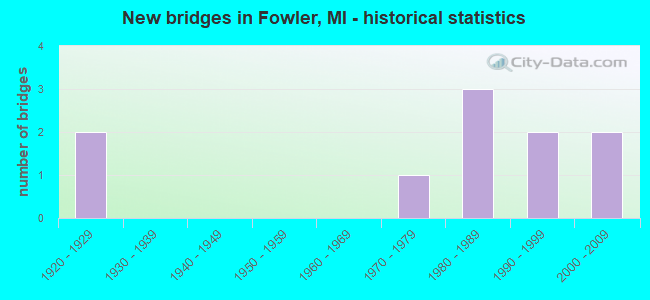
- New bridges - historical statistics
- 21920-1929
- 11970-1979
- 31980-1989
- 21990-1999
- 22000-2009
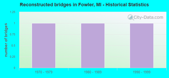
- Reconstructed bridges - Historical Statistics
- 11970-1979
- 11980-1989
- 11990-1999
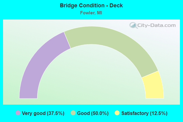
- Bridge Condition - Deck
- 37.5%Very good
- 50.0%Good
- 12.5%Satisfactory
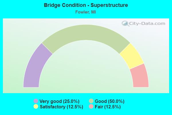
- Bridge Condition - Superstructure
- 25.0%Very good
- 50.0%Good
- 12.5%Satisfactory
- 12.5%Fair
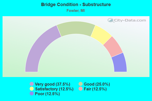
- Bridge Condition - Substructure
- 37.5%Very good
- 25.0%Good
- 12.5%Satisfactory
- 12.5%Fair
- 12.5%Poor
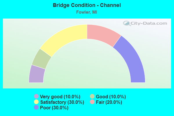
- Bridge Condition - Channel
- 10.0%Very good
- 10.0%Good
- 30.0%Satisfactory
- 20.0%Fair
- 30.0%Poor
Find on map >> Show street view
Structure Number: 1883, Location: SORREL ST IN FOWLER (Lat: 43.001861, Lng: -84.742728), Route carried "on" structure: State highway 21, Year Built: 2005, Status: Open, Structure Length: 0.89m (2.92ft), Average Daily Traffic: 3,160 (year 2007), Truck Traffic: 10%, Average Future Daily Traffic: 4,567 (year 2018), Design Load: HS 25 or greater, Features Intersected: WALTZ & STURGIS DRAIN
Minimum Vertical Clearance: 30.48m (100.00ft), Kilometerpoint: 7.720, Lanes on structure: 4, Base Highway Network: Yes (Inventory Route: 20, Subroute: 9), Owner: State Highway Agency, Approaching Roadway Width: 14.6m (47.9ft), Material/Design: Prestressed concrete, Design/Construction: Box Beam or Girders - Multiple, Number Of Spans In Main Unit: 1, Length of Maximum Span: 7.8m (25.6ft), Curb-To-Curb Width: 14.6m (47.9ft), Out-to-Out Width: 20.2m (66.3ft)
Condition: Deck: Satisfactory, Superstructure: Good, Substructure: Good, Channel: Very good, Operating Rating: 88.8 metric tons, Method Used To Determine Operating Rating: Load Factor (LF) rating reported by rating factor (RF) method using MS18 loading, Inventory Rating: 37.6 metric tons, Method Used To Determine Inventory Rating: Load Factor (LF) rating reported by rating factor (RF) method using MS18 loading, Structural Evaluation: Better than present minimum criteria, Deck Geometry: High priority of replacement, Waterway Adequacy: Equal to present desirable criteria, Approach Roadway Alignment: Equal to present desirable criteria, Designated Inspection Frequency: Every 24 months, Inspection Date: October 2020, Deck Structure Type: Concrete Cast-file-Place, Wearing Surface/Protective System: Wearing Surface: Monolithic Concrete, Deck Protection: Epoxy Coated Reinforcing
Find on map >> Show street view
Structure Number: 1906, Location: 3/4 MI E OF WRIGHT RD (Lat: 43.046811, Lng: -84.723281), Route carried "on" structure: County highway , Year Built: 1995, Status: Open, Structure Length: 1.43m (4.69ft), Average Daily Traffic: 1,202 (year 2011), Truck Traffic: 2%, Average Future Daily Traffic: 2,171 (year 2031), Design Load: HS 20, Features Intersected: W. BR. HAYWORTH(PEET CR), Facility Carried by Structure: COLONY ROAD
Minimum Vertical Clearance: 30.48m (100.00ft), Kilometerpoint: 9.286, Lanes on structure: 2, Owner: County Highway Agency, Approaching Roadway Width: 10.4m (34.1ft), Skew: 2 degrees, Material/Design: Prestressed concrete, Design/Construction: Box Beam or Girders - Multiple, Number Of Spans In Main Unit: 1, Length of Maximum Span: 14.3m (46.9ft), Curb-To-Curb Width: 9.8m (32.2ft), Out-to-Out Width: 10.4m (34.1ft)
Condition: Deck: Good, Superstructure: Good, Substructure: Very good, Channel: Fair, Operating Rating: 84.5 metric tons, Method Used To Determine Operating Rating: Load Factor (LF), Inventory Rating: 50.7 metric tons, Method Used To Determine Inventory Rating: Load Factor (LF), Structural Evaluation: Better than present minimum criteria, Deck Geometry: Somewhat better than minimum adequacy, Waterway Adequacy: Somewhat better than minimum adequacy, Approach Roadway Alignment: Somewhat better than minimum adequacy, Designated Inspection Frequency: Every 24 months, Inspection Date: October 2020, Deck Structure Type: Concrete Cast-file-Place, Wearing Surface/Protective System: Wearing Surface: Monolithic Concrete, Deck Protection: Epoxy Coated Reinforcing
Find on map >> Show street view
Structure Number: 192, Location: 1/4 MI N OF DEXTER TRAIL (Lat: 42.963222, Lng: -84.739561), Route carried "on" structure: County highway 1923, Year Built: 2007, Status: Open, Structure Length: 2.87m (9.42ft), Average Daily Traffic: 2,096 (year 2011), Truck Traffic: 5%, Average Future Daily Traffic: 3,786 (year 2031), Design Load: HS 20, Features Intersected: STONY CREEK, Facility Carried by Structure: WRIGHT ROAD
Minimum Vertical Clearance: 30.48m (100.00ft), Kilometerpoint: 21.605, Lanes on structure: 2, Owner: County Highway Agency, Approaching Roadway Width: 9.4m (30.8ft), Material/Design: Prestressed concrete, Design/Construction: Box Beam or Girders - Multiple, Number Of Spans In Main Unit: 1, Length of Maximum Span: 27.4m (89.9ft), Curb-To-Curb Width: 12.8m (42.0ft), Out-to-Out Width: 13.4m (44.0ft)
Condition: Deck: Very good, Superstructure: Very good, Substructure: Very good, Channel: Good, Operating Rating: 77.2 metric tons, Method Used To Determine Operating Rating: Load Factor (LF), Inventory Rating: 46.3 metric tons, Method Used To Determine Inventory Rating: Load Factor (LF), Structural Evaluation: Equal to present desirable criteria, Deck Geometry: Equal to present minimum criteria, Waterway Adequacy: Equal to present minimum criteria, Approach Roadway Alignment: Equal to present desirable criteria, Designated Inspection Frequency: Every 24 months, Inspection Date: October 2020, Deck Structure Type: Concrete Cast-file-Place, Wearing Surface/Protective System: Wearing Surface: Integral Concrete, Deck Protection: Epoxy Coated Reinforcing
Find on map >> Show street view
Structure Number: 1945, Location: 0.2 MI N OF CENTERLINE RD (Lat: 42.944350, Lng: -84.706564), Route carried "on" structure: County highway , Year Built: 1980, Status: Posted for load, Structure Length: 1.03m (3.38ft), Average Daily Traffic: 136 (year 2016), Average Future Daily Traffic: 246 (year 2036), Design Load: HS 20, Features Intersected: MUSKRAT CREEK, Facility Carried by Structure: DEXTER TRAIL
Minimum Vertical Clearance: 30.48m (100.00ft), Kilometerpoint: 4.938, Lanes on structure: 2, Owner: County Highway Agency, Approaching Roadway Width: 9.1m (29.9ft), Material/Design: Steel, Design/Construction: Culvert, Number Of Spans In Main Unit: 2, Length of Maximum Span: 4.8m (15.7ft)
Condition: Channel: Fair, Culverts: Serious, Operating Rating: 17.8 metric tons, Method Used To Determine Operating Rating: Load and Resistance Factor Rating (LRFR) rating reported by rating factor(RF) method using HL-93 loadings, Inventory Rating: 13.6 metric tons, Method Used To Determine Inventory Rating: Load and Resistance Factor Rating (LRFR) rating reported by rating factor(RF) method using HL-93 loadings, Structural Evaluation: High priority of corrective action, Waterway Adequacy: Better than present minimum criteria, Approach Roadway Alignment: Somewhat better than minimum adequacy, Bridge Posting: Required (Relationship of Operating Rating to Maximum Legal Load: > 39.9% below), Designated Inspection Frequency: Every 12 months, Inspection Date: October 2021
Find on map >> Show street view
Structure Number: 1947, Location: 0.3 MI W OF FOREST HILL (Lat: 42.958017, Lng: -84.689797), Route carried "on" structure: County highway , Year Built: 1920, Year Reconstructed: 1980, Status: Open, Structure Length: 1.89m (6.20ft), Average Daily Traffic: 132 (year 2011), Average Future Daily Traffic: 238 (year 2031), Design Load: HS 20, Features Intersected: STONY CREEK, Facility Carried by Structure: TAFT ROAD
Minimum Vertical Clearance: 30.48m (100.00ft), Kilometerpoint: 2.050, Lanes on structure: 2, Owner: County Highway Agency, Approaching Roadway Width: 8.5m (27.9ft), Material/Design: Prestressed concrete, Design/Construction: Box Beam or Girders - Multiple, Number Of Spans In Main Unit: 1, Length of Maximum Span: 18.2m (59.7ft), Curb-To-Curb Width: 5.5m (18.0ft), Out-to-Out Width: 5.5m (18.0ft)
Condition: Deck: Good, Superstructure: Fair, Substructure: Poor, Channel: Poor, Operating Rating: 58.1 metric tons, Method Used To Determine Operating Rating: Load Factor (LF), Inventory Rating: 34.8 metric tons, Method Used To Determine Inventory Rating: Load Factor (LF), Structural Evaluation: Meets minimum limits, Deck Geometry: High priority of corrective action, Waterway Adequacy: Superior to present desirable criteria, Approach Roadway Alignment: Meets minimum limits, Designated Inspection Frequency: Every 24 months, Inspection Date: October 2021, Bridge Improvement Cost: $268,000, Roadway Improvement Cost: $20,000, Total Project Cost: $240,000, Deck Structure Type: Concrete Precast Panels, Wearing Surface/Protective System: Wearing Surface: Bituminous
Find on map >> Show street view
Structure Number: 1949, Location: 0.3 MI S OF TAFT RD (Lat: 42.955111, Lng: -84.715058), Route carried "on" structure: County highway , Year Built: 1920, Year Reconstructed: 1983, Status: Open, Structure Length: 2.43m (7.97ft), Average Daily Traffic: 65 (year 2011), Average Future Daily Traffic: 117 (year 2031), Design Load: HS 20, Features Intersected: STONY CREEK, Facility Carried by Structure: BAUER ROAD
Minimum Vertical Clearance: 30.48m (100.00ft), Kilometerpoint: 0.967, Lanes on structure: 2, Owner: County Highway Agency, Approaching Roadway Width: 8.5m (27.9ft), Material/Design: Prestressed concrete, Design/Construction: Box Beam or Girders - Multiple, Number Of Spans In Main Unit: 1, Length of Maximum Span: 24.0m (78.7ft), Curb-To-Curb Width: 5.5m (18.0ft), Out-to-Out Width: 5.5m (18.0ft)
Condition: Deck: Good, Superstructure: Satisfactory, Substructure: Fair, Channel: Poor, Operating Rating: 52.1 metric tons, Method Used To Determine Operating Rating: Load Factor (LF), Inventory Rating: 31.2 metric tons, Method Used To Determine Inventory Rating: Load Factor (LF), Structural Evaluation: Somewhat better than minimum adequacy, Deck Geometry: Meets minimum limits, Waterway Adequacy: Equal to present desirable criteria, Approach Roadway Alignment: Meets minimum limits, Length Of Structure Improvement: 3.05m (10.01ft), Designated Inspection Frequency: Every 24 months, Inspection Date: October 2021, Bridge Improvement Cost: $320,000, Roadway Improvement Cost: $40,000, Total Project Cost: $360,000, Deck Structure Type: Concrete Precast Panels
Find on map >> Show street view
Structure Number: 195, Location: 0.2 MI N OF TAFT RD (Lat: 42.961550, Lng: -84.680547), Route carried "on" structure: County highway , Year Built: 1986, Status: Open, Structure Length: 2.01m (6.59ft), Average Daily Traffic: 80 (year 1979), Average Future Daily Traffic: 150 (year 2009), Design Load: HS 20, Features Intersected: STONY CREEK, Facility Carried by Structure: FOREST HILL ROAD
Minimum Vertical Clearance: 30.48m (100.00ft), Kilometerpoint: 14.856, Lanes on structure: 2, Owner: County Highway Agency, Approaching Roadway Width: 7.3m (24.0ft), Skew: 1 degrees, Material/Design: Prestressed concrete, Design/Construction: Box Beam or Girders - Multiple, Number Of Spans In Main Unit: 1, Length of Maximum Span: 20.1m (65.9ft), Curb-To-Curb Width: 9.1m (29.9ft), Out-to-Out Width: 9.4m (30.8ft)
Condition: Deck: Good, Superstructure: Good, Substructure: Good, Channel: Satisfactory, Operating Rating: 58.2 metric tons, Method Used To Determine Operating Rating: Load Factor (LF), Inventory Rating: 34.9 metric tons, Method Used To Determine Inventory Rating: Load Factor (LF), Structural Evaluation: Better than present minimum criteria, Deck Geometry: Better than present minimum criteria, Waterway Adequacy: Equal to present minimum criteria, Approach Roadway Alignment: Equal to present minimum criteria, Designated Inspection Frequency: Every 24 months, Inspection Date: October 2021, Deck Structure Type: Concrete Precast Panels, Wearing Surface/Protective System: Wearing Surface: Bituminous, Membrane: Built-up, Deck Protection: Epoxy Coated Reinforcing
Find on map >> Show street view
Structure Number: 1968, Location: 0.1 MI S OF PARKS RD (Lat: 42.972589, Lng: -84.759350), Route carried "on" structure: County highway , Year Built: 1999, Status: Open, Structure Length: 3.10m (10.17ft), Average Daily Traffic: 87 (year 2011), Truck Traffic: 5%, Average Future Daily Traffic: 157 (year 2031), Design Load: HS 25 or greater, Features Intersected: STONY CREEK, Facility Carried by Structure: TALLMAN ROAD
Minimum Vertical Clearance: 30.48m (100.00ft), Kilometerpoint: 3.216, Lanes on structure: 2, Owner: County Highway Agency, Approaching Roadway Width: 9.1m (29.9ft), Skew: 1 degrees, Material/Design: Prestressed concrete, Design/Construction: Box Beam or Girders - Multiple, Number Of Spans In Main Unit: 1, Length of Maximum Span: 29.8m (97.8ft), Curb-To-Curb Width: 9.4m (30.8ft), Out-to-Out Width: 10.1m (33.1ft)
Condition: Deck: Very good, Superstructure: Good, Substructure: Very good, Channel: Satisfactory, Inventory Rating: 85.6 metric tons, Method Used To Determine Inventory Rating: Load Factor (LF), Structural Evaluation: Better than present minimum criteria, Deck Geometry: Better than present minimum criteria, Waterway Adequacy: Better than present minimum criteria, Approach Roadway Alignment: Equal to present minimum criteria, Designated Inspection Frequency: Every 24 months, Inspection Date: October 2021, Deck Structure Type: Concrete Precast Panels, Wearing Surface/Protective System: Wearing Surface: Integral Concrete, Deck Protection: Epoxy Coated Reinforcing
Find on map >> Show street view
Structure Number: 1985, Location: 0.2 MI N OF COLONY RD (Lat: 43.050375, Lng: -84.719542), Route carried "on" structure: County highway , Year Built: 1970, Year Reconstructed: 1999, Status: Open, Structure Length: 0.79m (2.59ft), Average Daily Traffic: 160 (year 1979), Average Future Daily Traffic: 300 (year 2009), Design Load: HS 20, Features Intersected: PEET CREEK, Facility Carried by Structure: BAUER ROAD
Minimum Vertical Clearance: 30.48m (100.00ft), Kilometerpoint: 8.634, Lanes on structure: 2, Owner: County Highway Agency, Approaching Roadway Width: 8.5m (27.9ft), Material/Design: Prestressed concrete, Design/Construction: Box Beam or Girders - Multiple, Number Of Spans In Main Unit: 1, Length of Maximum Span: 7.3m (24.0ft), Curb-To-Curb Width: 6.1m (20.0ft), Out-to-Out Width: 6.6m (21.7ft)
Condition: Deck: Very good, Superstructure: Very good, Substructure: Satisfactory, Channel: Satisfactory, Operating Rating: 89.7 metric tons, Method Used To Determine Operating Rating: Load Factor (LF), Inventory Rating: 53.8 metric tons, Method Used To Determine Inventory Rating: Load Factor (LF), Structural Evaluation: Equal to present minimum criteria, Deck Geometry: Meets minimum limits, Waterway Adequacy: Meets minimum limits, Approach Roadway Alignment: Equal to present minimum criteria, Designated Inspection Frequency: Every 24 months, Inspection Date: October 2021, Deck Structure Type: Concrete Precast Panels, Wearing Surface/Protective System: Wearing Surface: Bituminous
Find on map >> Show street view
Structure Number: 1997, Location: 0.1 MI E OF WRIGHT RD (Lat: 43.032278, Lng: -84.733642), Route carried "on" structure: County highway , Year Built: 1983, Status: Posted for load, Structure Length: 0.67m (2.20ft), Average Daily Traffic: 300 (year 1979), Average Future Daily Traffic: 540 (year 2009), Design Load: HS 20, Features Intersected: PEET CREEK, Facility Carried by Structure: KINLEY ROAD
Minimum Vertical Clearance: 30.48m (100.00ft), Kilometerpoint: 8.475, Lanes on structure: 2, Owner: County Highway Agency, Approaching Roadway Width: 10.4m (34.1ft), Material/Design: Steel, Design/Construction: Culvert, Number Of Spans In Main Unit: 2, Length of Maximum Span: 3.0m (9.8ft)
Condition: Channel: Poor, Culverts: Serious, Operating Rating: 14.9 metric tons, Method Used To Determine Operating Rating: Load and Resistance Factor Rating (LRFR) rating reported by rating factor(RF) method using HL-93 loadings, Inventory Rating: 11.7 metric tons, Method Used To Determine Inventory Rating: Load and Resistance Factor Rating (LRFR) rating reported by rating factor(RF) method using HL-93 loadings, Structural Evaluation: High priority of corrective action, Waterway Adequacy: Somewhat better than minimum adequacy, Approach Roadway Alignment: Somewhat better than minimum adequacy, Bridge Posting: Required (Relationship of Operating Rating to Maximum Legal Load: 30.0 - 39.9% below), Designated Inspection Frequency: Every 12 months, Inspection Date: October 2021