Bridge Statistics for Freeville, New York (NY)
Condition, Traffic, Stress, Structural Evaluation, Project Costs
- National Bridge Inventory (NBI) Statistics
- 13Number of bridges
- 98ft / 29.9mTotal length
- $17,814,000Total costs
- 22,029Total average daily traffic
- 1,738Total average daily truck traffic
- 24,947Total future (year 2022) average daily traffic
- National Bridge Inventory (NBI) Registered Bridges for Freeville
- No street view available for this location
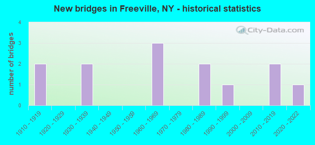
- New bridges - historical statistics
- 21910-1919
- 21930-1939
- 31960-1969
- 21980-1989
- 11990-1999
- 22010-2019
- 12020-2022
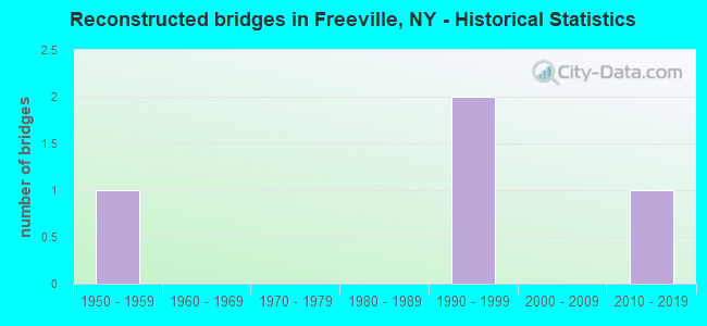
- Reconstructed bridges - Historical Statistics
- 11950-1959
- 01960-1969
- 01970-1979
- 01980-1989
- 21990-1999
- 02000-2009
- 12010-2019
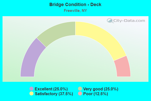
- Bridge Condition - Deck
- 25.0%Excellent
- 25.0%Very good
- 37.5%Satisfactory
- 12.5%Poor
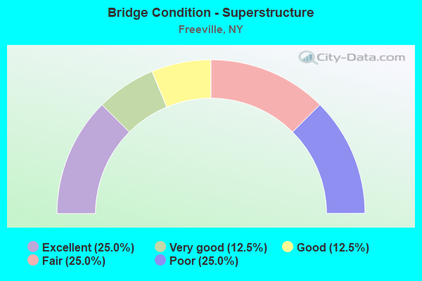
- Bridge Condition - Superstructure
- 25.0%Excellent
- 12.5%Very good
- 12.5%Good
- 25.0%Fair
- 25.0%Poor
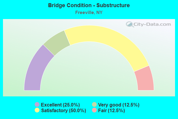
- Bridge Condition - Substructure
- 25.0%Excellent
- 12.5%Very good
- 50.0%Satisfactory
- 12.5%Fair
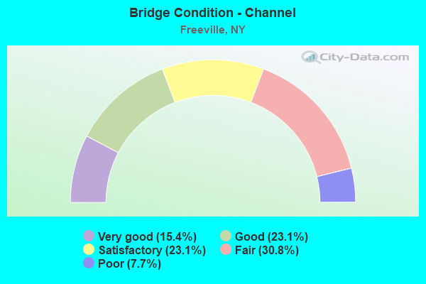
- Bridge Condition - Channel
- 15.4%Very good
- 23.1%Good
- 23.1%Satisfactory
- 30.8%Fair
- 7.7%Poor
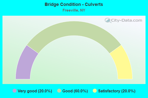
- Bridge Condition - Culverts
- 20.0%Very good
- 60.0%Good
- 20.0%Satisfactory
Find on map >> Show street view
Structure Number: 102419, Location: JCT OF RTS 38 + 366 (Lat: 42.514208, Lng: -76.347172), Route carried "on" structure: State highway 38, Year Built: 2019, Status: Open, Structure Length: 2.41m (7.91ft), Average Daily Traffic: 2,669 (year 2018), Truck Traffic: 11%, Average Future Daily Traffic: 2,685 (year 2040), Design Load: HS 20, Features Intersected: FALL CREEK
Minimum Vertical Clearance: 32.69m (107.25ft), Kilometerpoint: 13.033, Lanes on structure: 2, Owner: State Highway Agency, Approaching Roadway Width: 12.8m (42.0ft), Skew: 6 degrees, Material/Design: Prestressed concrete, Design/Construction: Box Beam or Girders - Multiple, Number Of Spans In Main Unit: 1, Length of Maximum Span: 22.9m (75.1ft), Curb or Sidewalk Widths: Left: 2.1m (6.9ft), Right: 2.1m (6.9ft), Curb-To-Curb Width: 9.8m (32.2ft), Out-to-Out Width: 15.0m (49.2ft)
Condition: Deck: Very good, Superstructure: Excellent, Substructure: Excellent, Channel: Good, Operating Rating: 88.9 metric tons, Method Used To Determine Operating Rating: Field evaluation and documented engineering judgment, Inventory Rating: 32.7 metric tons, Method Used To Determine Inventory Rating: Field evaluation and documented engineering judgment, Structural Evaluation: Superior to present desirable criteria, Deck Geometry: Meets minimum limits, Waterway Adequacy: Equal to present minimum criteria, Approach Roadway Alignment: Equal to present desirable criteria, Length Of Structure Improvement: 2.40m (7.87ft), Designated Inspection Frequency: Every 24 months, Inspection Date: November 2021, Bridge Improvement Cost: $1,723,000, Roadway Improvement Cost: $1,009,000, Total Project Cost: $2,732,000 ( Estimate for 2021), Deck Structure Type: Concrete Cast-file-Place, Wearing Surface/Protective System: Wearing Surface: Integral Concrete
Find on map >> Show street view
Structure Number: 104678, Location: 1.6 MI NE JCT RTS 366 +13 (Lat: 42.495397, Lng: -76.371378), Route carried "on" structure: State highway 366, Year Built: 1932, Year Reconstructed: 1995, Status: Posted for load-capacity, Structure Length: 3.81m (12.50ft), Average Daily Traffic: 2,639 (year 2019), Truck Traffic: 11%, Average Future Daily Traffic: 3,205 (year 2040), Design Load: HS 20, Features Intersected: FALL CREEK
Minimum Vertical Clearance: 30+ m (98+ ft), Kilometerpoint: 12.100, Lanes on structure: 2, Base Highway Network: Yes, Owner: State Highway Agency, Approaching Roadway Width: 9.1m (29.9ft), Material/Design: Steel, Design/Construction: Truss - Thru, Number Of Spans In Main Unit: 1, Length of Maximum Span: 36.5m (119.8ft), Curb or Sidewalk Widths: Left: 1.8m (5.9ft), Right: 0.0m, Curb-To-Curb Width: 7.3m (24.0ft), Out-to-Out Width: 8.1m (26.6ft)
Condition: Deck: Satisfactory, Superstructure: Fair, Substructure: Satisfactory, Channel: Very good, Operating Rating: 81.6 metric tons, Method Used To Determine Operating Rating: Load Factor (LF), Inventory Rating: 49.0 metric tons, Method Used To Determine Inventory Rating: Load Factor (LF), Structural Evaluation: Somewhat better than minimum adequacy, Deck Geometry: High priority of replacement, Waterway Adequacy: Equal to present minimum criteria, Approach Roadway Alignment: Equal to present desirable criteria, Length Of Structure Improvement: 3.81m (12.50ft), Designated Inspection Frequency: Every 24 months, Critical Feature Inspection Frequency: Every 24 months, Inspection Date: October 2020, Critical Feature Inspection Date: October 2020, Bridge Improvement Cost: $2,875,000, Roadway Improvement Cost: $1,684,000, Total Project Cost: $4,559,000 ( Estimate for 2021), Deck Structure Type: Concrete Cast-file-Place, Wearing Surface/Protective System: Wearing Surface: Integral Concrete, Deck Protection: Epoxy Coated Reinforcing
Find on map >> Show street view
Structure Number: 104679, Location: 2.5 MI NE JCT SH 366 & SH (Lat: 42.504589, Lng: -76.359914), Route carried "on" structure: State highway 366, Year Built: 1932, Year Reconstructed: 1995, Status: Open, Structure Length: 2.44m (8.01ft), Average Daily Traffic: 2,639 (year 2019), Truck Traffic: 11%, Average Future Daily Traffic: 2,655 (year 2040), Design Load: HS 20, Features Intersected: FALL CREEK
Minimum Vertical Clearance: 30+ m (98+ ft), Kilometerpoint: 13.564, Lanes on structure: 2, Base Highway Network: Yes, Owner: State Highway Agency, Approaching Roadway Width: 9.1m (29.9ft), Skew: 3 degrees, Material/Design: Steel, Design/Construction: Girder and Floorbeam System, Number Of Spans In Main Unit: 1, Length of Maximum Span: 22.8m (74.8ft), Curb or Sidewalk Widths: Left: 1.8m (5.9ft), Right: 0.0m, Curb-To-Curb Width: 7.3m (24.0ft), Out-to-Out Width: 8.3m (27.2ft)
Condition: Deck: Satisfactory, Superstructure: Fair, Substructure: Satisfactory, Channel: Good, Operating Rating: 57.2 metric tons, Method Used To Determine Operating Rating: Load Factor (LF), Inventory Rating: 33.6 metric tons, Method Used To Determine Inventory Rating: Load Factor (LF), Structural Evaluation: Somewhat better than minimum adequacy, Deck Geometry: High priority of replacement, Waterway Adequacy: Equal to present minimum criteria, Approach Roadway Alignment: Equal to present desirable criteria, Length Of Structure Improvement: 2.43m (7.97ft), Designated Inspection Frequency: Every 24 months, Critical Feature Inspection Frequency: Every 24 months, Inspection Date: October 2020, Critical Feature Inspection Date: October 2020, Bridge Improvement Cost: $727,000, Roadway Improvement Cost: $426,000, Total Project Cost: $1,153,000 ( Estimate for 2021), Deck Structure Type: Concrete Cast-file-Place, Wearing Surface/Protective System: Wearing Surface: Integral Concrete, Deck Protection: Epoxy Coated Reinforcing
Find on map >> Show street view
Structure Number: 320978, Location: 1.6 MI SW OF MCLEAN (Lat: 42.533914, Lng: -76.310625), Route carried "on" structure: County highway , Year Built: 1915, Year Reconstructed: 2017, Status: Posted for load, Structure Length: 2.07m (6.79ft), Average Daily Traffic: 213 (year 2017), Truck Traffic: 8%, Average Future Daily Traffic: 298 (year 2037), Features Intersected: FALL CREEK, Facility Carried by Structure: W MALLORYVILLE RD
Minimum Vertical Clearance: 30+ m (98+ ft), Kilometerpoint: 0.338, Lanes on structure: 1, Owner: County Highway Agency, Approaching Roadway Width: 4.3m (14.1ft), Skew: 1 degrees, Material/Design: Steel, Design/Construction: Truss - Thru, Number Of Spans In Main Unit: 1, Length of Maximum Span: 19.5m (64.0ft), Curb-To-Curb Width: 4.4m (14.4ft), Out-to-Out Width: 4.9m (16.1ft)
Condition: Deck: Excellent, Superstructure: Good, Substructure: Satisfactory, Channel: Fair, Operating Rating: 21.8 metric tons, Method Used To Determine Operating Rating: Load Factor (LF), Inventory Rating: 12.7 metric tons, Method Used To Determine Inventory Rating: Load Factor (LF), Structural Evaluation: Meets minimum limits, Deck Geometry: High priority of replacement, Waterway Adequacy: Better than present minimum criteria, Approach Roadway Alignment: Somewhat better than minimum adequacy, Bridge Posting: Required (Relationship of Operating Rating to Maximum Legal Load: > 39.9% below), Length Of Structure Improvement: 2.07m (6.79ft), Designated Inspection Frequency: Every 12 months, Critical Feature Inspection Frequency: Every 12 months, Inspection Date: April 2021, Critical Feature Inspection Date: April 2021, Bridge Improvement Cost: $769,000, Roadway Improvement Cost: $450,000, Total Project Cost: $1,219,000 ( Estimate for 2021), Deck Structure Type: Concrete Cast-file-Place, Wearing Surface/Protective System: Wearing Surface: Integral Concrete, Deck Protection: Epoxy Coated Reinforcing
Find on map >> Show street view
Structure Number: 320979, Location: 1.5 MILES NE OF FREEVILLE (Lat: 42.527736, Lng: -76.321894), Route carried "on" structure: Other road , Year Built: 2017, Status: Open, Structure Length: 3.72m (12.20ft), Truck Traffic: 8%, Features Intersected: FALL CREEK, Facility Carried by Structure: RED MILL ROAD
Minimum Vertical Clearance: 30+ m (98+ ft), Kilometerpoint: 1.368, Lanes on structure: 2, Owner: County Highway Agency, Approaching Roadway Width: 7.3m (24.0ft), Material/Design: Steel, Design/Construction: Stringer/Multi-beam, Number Of Spans In Main Unit: 1, Length of Maximum Span: 36.6m (120.1ft), Curb-To-Curb Width: 7.3m (24.0ft), Out-to-Out Width: 8.3m (27.2ft)
Condition: Deck: Very good, Superstructure: Very good, Substructure: Very good, Channel: Good, Operating Rating: 83.5 metric tons, Method Used To Determine Operating Rating: Load Factor (LF), Inventory Rating: 49.9 metric tons, Method Used To Determine Inventory Rating: Load Factor (LF), Structural Evaluation: Equal to present desirable criteria, Deck Geometry: Equal to present minimum criteria, Waterway Adequacy: Meets minimum limits, Approach Roadway Alignment: Equal to present desirable criteria, Length Of Structure Improvement: 3.71m (12.17ft), Designated Inspection Frequency: Every 24 months, Inspection Date: October 2021, Bridge Improvement Cost: $780,000, Roadway Improvement Cost: $457,000, Total Project Cost: $1,236,000 ( Estimate for 2021), Deck Structure Type: Concrete Cast-file-Place, Wearing Surface/Protective System: Wearing Surface: Integral Concrete, Deck Protection: Epoxy Coated Reinforcing
Find on map >> Show street view
Structure Number: 320983, Location: 1.6 MILES NW OF DRYDEN (Lat: 42.494889, Lng: -76.328642), Route carried "on" structure: Other road , Year Built: 2020, Status: Open, Structure Length: 3.05m (10.01ft), Average Daily Traffic: 1,324 (year 2019), Truck Traffic: 8%, Average Future Daily Traffic: 1,854 (year 2039), Features Intersected: Virgil Creek, Facility Carried by Structure: South George Road
Minimum Vertical Clearance: 32.69m (107.25ft), Kilometerpoint: 0.692, Lanes on structure: 2, Owner: County Highway Agency, Approaching Roadway Width: 8.5m (27.9ft), Material/Design: Steel, Design/Construction: Stringer/Multi-beam, Number Of Spans In Main Unit: 1, Length of Maximum Span: 30.5m (100.1ft), Curb-To-Curb Width: 8.5m (27.9ft), Out-to-Out Width: 9.5m (31.2ft)
Condition: Deck: Excellent, Superstructure: Excellent, Substructure: Excellent, Channel: Very good, Operating Rating: 94.3 metric tons, Method Used To Determine Operating Rating: Field evaluation and documented engineering judgment, Inventory Rating: 40.8 metric tons, Method Used To Determine Inventory Rating: Field evaluation and documented engineering judgment, Structural Evaluation: Superior to present desirable criteria, Deck Geometry: Somewhat better than minimum adequacy, Waterway Adequacy: Better than present minimum criteria, Approach Roadway Alignment: Better than present minimum criteria, Length Of Structure Improvement: 3.04m (9.97ft), Designated Inspection Frequency: Every 24 months, Inspection Date: December 2020, Bridge Improvement Cost: $694,000, Roadway Improvement Cost: $407,000, Total Project Cost: $1,101,000 ( Estimate for 2021), Deck Structure Type: Concrete Cast-file-Place, Wearing Surface/Protective System: Wearing Surface: Integral Concrete, Deck Protection: Epoxy Coated Reinforcing
Find on map >> Show street view
Structure Number: 320985, Location: E SIDE ON FREEVILLE TN LN (Lat: 42.516700, Lng: -76.335533), Route carried "on" structure: Other road , Year Built: 1988, Status: Open, Structure Length: 1.40m (4.59ft), Average Daily Traffic: 692 (year 2016), Truck Traffic: 7%, Average Future Daily Traffic: 969 (year 2036), Design Load: HS 20, Features Intersected: FALL CREEK, Facility Carried by Structure: HERMAN ROAD
Minimum Vertical Clearance: 30+ m (98+ ft), Kilometerpoint: 0.644, Lanes on structure: 2, Owner: County Highway Agency, Approaching Roadway Width: 5.5m (18.0ft), Material/Design: Aluminum, Iron, Design/Construction: Culvert, Number Of Spans In Main Unit: 2, Length of Maximum Span: 6.4m (21.0ft)
Condition: Channel: Fair, Culverts: Good, Operating Rating: 77.1 metric tons, Method Used To Determine Operating Rating: Field evaluation and documented engineering judgment, Inventory Rating: 32.7 metric tons, Method Used To Determine Inventory Rating: Field evaluation and documented engineering judgment, Structural Evaluation: Better than present minimum criteria, Waterway Adequacy: Meets minimum limits, Approach Roadway Alignment: Better than present minimum criteria, Length Of Structure Improvement: 1.40m (4.59ft), Designated Inspection Frequency: Every 24 months, Inspection Date: May 2021, Bridge Improvement Cost: $178,000, Roadway Improvement Cost: $104,000, Total Project Cost: $283,000 ( Estimate for 2021)
Find on map >> Show street view
Structure Number: 320986, Location: 0.7 MI W OF FREEVILLE (Lat: 42.512689, Lng: -76.359397), Route carried "on" structure: Other road , Year Built: 1910, Year Reconstructed: 1964, Status: Open, Structure Length: 1.83m (6.00ft), Average Daily Traffic: 338 (year 2019), Truck Traffic: 8%, Average Future Daily Traffic: 473 (year 2039), Features Intersected: FALL CREEK, Facility Carried by Structure: MILL STREET
Minimum Vertical Clearance: 30+ m (98+ ft), Kilometerpoint: 0.306, Lanes on structure: 1, Owner: County Highway Agency, Approaching Roadway Width: 4.9m (16.1ft), Material/Design: Steel, Design/Construction: Truss - Thru, Number Of Spans In Main Unit: 1, Length of Maximum Span: 18.0m (59.1ft), Curb-To-Curb Width: 4.5m (14.8ft), Out-to-Out Width: 5.6m (18.4ft)
Condition: Deck: Poor, Superstructure: Poor, Substructure: Satisfactory, Channel: Satisfactory, Operating Rating: 32.7 metric tons, Method Used To Determine Operating Rating: Load Factor (LF), Inventory Rating: 19.1 metric tons, Method Used To Determine Inventory Rating: Load Factor (LF), Structural Evaluation: Meets minimum limits, Deck Geometry: High priority of replacement, Waterway Adequacy: Equal to present desirable criteria, Approach Roadway Alignment: Equal to present minimum criteria, Length Of Structure Improvement: 1.82m (5.97ft), Designated Inspection Frequency: Every 24 months, Critical Feature Inspection Frequency: Every 24 months, Inspection Date: October 2021, Critical Feature Inspection Date: October 2021, Bridge Improvement Cost: $959,000, Roadway Improvement Cost: $561,000, Total Project Cost: $1,520,000 ( Estimate for 2021), Deck Structure Type: Concrete Cast-file-Place, Wearing Surface/Protective System: Wearing Surface: Bituminous
Find on map >> Show street view
Structure Number: 321033, Location: 1.7 MI NE OF FREEVILLE (Lat: 42.517542, Lng: -76.338069), Route carried "on" structure: County highway , Year Built: 1965, Status: Open, Structure Length: 1.74m (5.71ft), Average Daily Traffic: 4,772 (year 2018), Truck Traffic: 4%, Average Future Daily Traffic: 4,801 (year 2040), Features Intersected: FALL CREEK, Facility Carried by Structure: FALL CREEK ROAD
Minimum Vertical Clearance: 30+ m (98+ ft), Kilometerpoint: 0.837, Lanes on structure: 2, Owner: County Highway Agency, Approaching Roadway Width: 6.1m (20.0ft), Skew: 1 degrees, Material/Design: Concrete continuous, Design/Construction: Culvert, Number Of Spans In Main Unit: 3, Length of Maximum Span: 5.4m (17.7ft), Curb-To-Curb Width: 9.6m (31.5ft), Out-to-Out Width: 10.6m (34.8ft)
Condition: Channel: Fair, Culverts: Good, Operating Rating: 76.5 metric tons, Method Used To Determine Operating Rating: Field evaluation and documented engineering judgment, Inventory Rating: 32.7 metric tons, Method Used To Determine Inventory Rating: Field evaluation and documented engineering judgment, Structural Evaluation: Better than present minimum criteria, Deck Geometry: Meets minimum limits, Waterway Adequacy: Meets minimum limits, Approach Roadway Alignment: Superior to present desirable criteria, Length Of Structure Improvement: 1.73m (5.68ft), Designated Inspection Frequency: Every 24 months, Inspection Date: April 2021, Bridge Improvement Cost: $626,000, Roadway Improvement Cost: $366,000, Total Project Cost: $992,000 ( Estimate for 2021), Wearing Surface/Protective System: Wearing Surface: Bituminous
Find on map >> Show street view
Structure Number: 331413, Location: 1 MI NE OF FREEVILLE (Lat: 42.519933, Lng: -76.327742), Route carried "on" structure: County highway , Year Built: 1965, Status: Open, Structure Length: 2.01m (6.59ft), Average Daily Traffic: 3,442 (year 2020), Truck Traffic: 8%, Average Future Daily Traffic: 3,463 (year 2040), Features Intersected: FALL CREEK, Facility Carried by Structure: FALL CREEK ROAD
Minimum Vertical Clearance: 30+ m (98+ ft), Kilometerpoint: 0.660, Lanes on structure: 2, Owner: County Highway Agency, Approaching Roadway Width: 9.8m (32.2ft), Skew: 3 degrees, Material/Design: Concrete continuous, Design/Construction: Culvert, Number Of Spans In Main Unit: 3, Length of Maximum Span: 6.4m (21.0ft), Curb-To-Curb Width: 9.7m (31.8ft), Out-to-Out Width: 10.7m (35.1ft)
Condition: Channel: Fair, Culverts: Good, Operating Rating: 77.1 metric tons, Method Used To Determine Operating Rating: Field evaluation and documented engineering judgment, Inventory Rating: 32.7 metric tons, Method Used To Determine Inventory Rating: Field evaluation and documented engineering judgment, Structural Evaluation: Better than present minimum criteria, Deck Geometry: Meets minimum limits, Waterway Adequacy: Meets minimum limits, Approach Roadway Alignment: Equal to present desirable criteria, Length Of Structure Improvement: 2.01m (6.59ft), Designated Inspection Frequency: Every 24 months, Inspection Date: May 2020, Bridge Improvement Cost: $675,000, Roadway Improvement Cost: $396,000, Total Project Cost: $1,071,000 ( Estimate for 2021), Wearing Surface/Protective System: Wearing Surface: Bituminous
Find on map >> Show street view
Structure Number: 331417, Location: 6.8 MI SE OF WEST GROTON (Lat: 42.517981, Lng: -76.381906), Route carried "on" structure: County highway , Year Built: 1997, Status: Open, Structure Length: 1.10m (3.61ft), Average Daily Traffic: 2,196 (year 2019), Truck Traffic: 5%, Average Future Daily Traffic: 3,070 (year 2040), Design Load: HS 25 or greater, Features Intersected: MILL CREEK, Facility Carried by Structure: WEST DRYDEN ROAD
Minimum Vertical Clearance: 30+ m (98+ ft), Kilometerpoint: 10.282, Lanes on structure: 2, Owner: County Highway Agency, Approaching Roadway Width: 9.8m (32.2ft), Skew: 2 degrees, Material/Design: Concrete, Design/Construction: Culvert, Number Of Spans In Main Unit: 1, Length of Maximum Span: 10.6m (34.8ft)
Condition: Channel: Satisfactory, Culverts: Very good, Operating Rating: 80.2 metric tons, Method Used To Determine Operating Rating: Field evaluation and documented engineering judgment, Inventory Rating: 40.8 metric tons, Method Used To Determine Inventory Rating: Field evaluation and documented engineering judgment, Structural Evaluation: Equal to present desirable criteria, Waterway Adequacy: Meets minimum limits, Approach Roadway Alignment: Equal to present desirable criteria, Length Of Structure Improvement: 1.09m (3.58ft), Designated Inspection Frequency: Every 24 months, Inspection Date: September 2021, Bridge Improvement Cost: $248,000, Roadway Improvement Cost: $145,000, Total Project Cost: $393,000 ( Estimate for 2021)
Find on map >> Show street view
Structure Number: 331418, Location: IN ETNA (Lat: 42.485339, Lng: -76.384544), Route carried "on" structure: County highway , Year Built: 1960, Status: Posted for load, Structure Length: 3.60m (11.81ft), Average Daily Traffic: 439 (year 2020), Truck Traffic: 5%, Average Future Daily Traffic: 543 (year 2040), Design Load: HS 20, Features Intersected: FALL CREEK, Facility Carried by Structure: COUNTY ROAD 109
Minimum Vertical Clearance: 30+ m (98+ ft), Kilometerpoint: 9.654, Lanes on structure: 2, Owner: County Highway Agency, Approaching Roadway Width: 7.0m (23.0ft), Material/Design: Steel, Design/Construction: Girder and Floorbeam System, Number Of Spans In Main Unit: 1, Length of Maximum Span: 35.4m (116.1ft), Curb or Sidewalk Widths: Left: 0.6m (2.0ft), Right: 0.6m (2.0ft), Curb-To-Curb Width: 7.3m (24.0ft), Out-to-Out Width: 8.8m (28.9ft)
Condition: Deck: Satisfactory, Superstructure: Poor, Substructure: Fair, Channel: Satisfactory, Operating Rating: 44.5 metric tons, Method Used To Determine Operating Rating: Load Factor (LF), Inventory Rating: 32.7 metric tons, Method Used To Determine Inventory Rating: Load Factor (LF), Structural Evaluation: Meets minimum limits, Deck Geometry: Meets minimum limits, Waterway Adequacy: Equal to present desirable criteria, Approach Roadway Alignment: Equal to present desirable criteria, Bridge Posting: Required (Relationship of Operating Rating to Maximum Legal Load: > 39.9% below), Length Of Structure Improvement: 3.59m (11.78ft), Designated Inspection Frequency: Every 12 months, Critical Feature Inspection Frequency: Every 12 months, Inspection Date: August 2021, Critical Feature Inspection Date: August 2021, Bridge Improvement Cost: $877,000, Roadway Improvement Cost: $514,000, Total Project Cost: $1,391,000 ( Estimate for 2021), Deck Structure Type: Open Grating, Wearing Surface/Protective System: Wearing Surface: Other
Find on map >> Show street view
Structure Number: 336786, Location: 3.5 MI W OF DRYDEN (Lat: 42.480194, Lng: -76.354478), Route carried "on" structure: County highway , Year Built: 1988, Status: Open, Structure Length: 0.73m (2.40ft), Average Daily Traffic: 666 (year 2020), Truck Traffic: 11%, Average Future Daily Traffic: 931 (year 2040), Features Intersected: TRIB FALL CREEK, Facility Carried by Structure: CO RD 164
Minimum Vertical Clearance: 30+ m (98+ ft), Kilometerpoint: 11.360, Lanes on structure: 2, Owner: County Highway Agency, Approaching Roadway Width: 6.1m (20.0ft), Material/Design: Aluminum, Iron, Design/Construction: Culvert, Number Of Spans In Main Unit: 1, Length of Maximum Span: 7.0m (23.0ft)
Condition: Channel: Poor, Culverts: Satisfactory, Operating Rating: 77.6 metric tons, Method Used To Determine Operating Rating: Field evaluation and documented engineering judgment, Inventory Rating: 32.7 metric tons, Method Used To Determine Inventory Rating: Field evaluation and documented engineering judgment, Structural Evaluation: Equal to present minimum criteria, Waterway Adequacy: Meets minimum limits, Approach Roadway Alignment: Equal to present desirable criteria, Length Of Structure Improvement: 0.73m (2.40ft), Designated Inspection Frequency: Every 24 months, Inspection Date: April 2021, Bridge Improvement Cost: $103,000, Roadway Improvement Cost: $61,000, Total Project Cost: $164,000 ( Estimate for 2021)