Bridge Statistics for Fruit Cove, Florida (FL)
Condition, Traffic, Stress, Structural Evaluation, Project Costs
- National Bridge Inventory (NBI) Statistics
- 10Number of bridges
- 328ft / 99.7mTotal length
- 165,541Total average daily traffic
- 10,774Total average daily truck traffic
- 287,212Total future (year 2042) average daily traffic
- National Bridge Inventory (NBI) Registered Bridges for Fruit Cove
- No street view available for this location
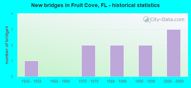
- New bridges - historical statistics
- 11950-1959
- 21970-1979
- 21980-1989
- 21990-1999
- 32000-2009


- Bridge Condition - Deck
- 66.7%Good
- 33.3%Satisfactory

- Bridge Condition - Superstructure
- 66.7%Good
- 33.3%Satisfactory

- Bridge Condition - Substructure
- 16.7%Very good
- 66.7%Good
- 16.7%Satisfactory

- Bridge Condition - Channel
- 55.6%Good
- 44.4%Satisfactory

- Bridge Condition - Culverts
- 25.0%Good
- 50.0%Satisfactory
- 25.0%Fair
Find on map >> Show street view
Structure Number: 100604, Location: 1.6MI WEST OF SR-39 (Lat: 28.032025, Lng: -82.134156), Route carried "on" structure: Interstate 4, Year Built: 1999, Status: Open, Structure Length: 4.79m (15.72ft), Average Daily Traffic: 56,750 (year 2020), Truck Traffic: 12%, Average Future Daily Traffic: 98,461 (year 2042), Design Load: HS 20+Mod, Features Intersected: ALEXANDER ST (CR-574)
Minimum Vertical Clearance: 30+ m (98+ ft), Kilometerpoint: 45.073, Lanes on structure: 3, Lanes under structure: 7, Base Highway Network: Yes, Owner: State Highway Agency, Approaching Roadway Width: 17.1m (56.1ft), Skew: 2 degrees, Material/Design: Prestressed concrete, Design/Construction: Stringer/Multi-beam, Number Of Spans In Main Unit: 2, Length of Maximum Span: 23.9m (78.4ft), Curb-To-Curb Width: 17.1m (56.1ft), Out-to-Out Width: 18.0m (59.1ft)
Condition: Deck: Good, Superstructure: Good, Substructure: Very good, Inventory Rating: 71.2 metric tons, Method Used To Determine Inventory Rating: Load Factor (LF), Structural Evaluation: Better than present minimum criteria, Deck Geometry: Equal to present minimum criteria, Underclear: Equal to present minimum criteria, Approach Roadway Alignment: Equal to present desirable criteria, Designated Inspection Frequency: Every 24 months, Inspection Date: October 2020, Deck Structure Type: Concrete Cast-file-Place
Find on map >> Show street view
Structure Number: 780052, Location: 5.4 MI. S. OF DUVAL CO. (Lat: 30.068500, Lng: -81.656792), Route carried "on" structure: State highway 13, Year Built: 1957, Status: Open, Structure Length: 0.91m (2.99ft), Average Daily Traffic: 8,300 (year 2020), Truck Traffic: 7%, Average Future Daily Traffic: 14,400 (year 2042), Design Load: H 15, Features Intersected: REMINGTON CREEK
Minimum Vertical Clearance: 30+ m (98+ ft), Kilometerpoint: 19.143, Lanes on structure: 2, Owner: State Highway Agency, Approaching Roadway Width: 8.5m (27.9ft), Material/Design: Steel, Design/Construction: Culvert, Number Of Spans In Main Unit: 2, Length of Maximum Span: 4.3m (14.1ft)
Condition: Channel: Satisfactory, Culverts: Fair, Structural Evaluation: Somewhat better than minimum adequacy, Waterway Adequacy: Equal to present desirable criteria, Approach Roadway Alignment: Equal to present desirable criteria, Designated Inspection Frequency: Every 24 months, Inspection Date: September 2021
Find on map >> Show street view
Structure Number: 780053, Location: 3 MI. S. OF DUVAL CO. (Lat: 30.090592, Lng: -81.629050), Route carried "on" structure: State highway 13, Year Built: 1971, Status: Open, Structure Length: 0.64m (2.10ft), Average Daily Traffic: 8,300 (year 2020), Truck Traffic: 7%, Average Future Daily Traffic: 14,400 (year 2042), Design Load: H 20, Features Intersected: MILL CREEK
Minimum Vertical Clearance: 30+ m (98+ ft), Kilometerpoint: 22.780, Lanes on structure: 2, Owner: State Highway Agency, Approaching Roadway Width: 9.2m (30.2ft), Material/Design: Concrete, Design/Construction: Culvert, Number Of Spans In Main Unit: 2, Length of Maximum Span: 3.0m (9.8ft)
Condition: Channel: Good, Culverts: Satisfactory, Inventory Rating: 88.9 metric tons, Method Used To Determine Inventory Rating: Load Factor (LF), Structural Evaluation: Equal to present minimum criteria, Waterway Adequacy: Equal to present desirable criteria, Approach Roadway Alignment: Equal to present desirable criteria, Designated Inspection Frequency: Every 24 months, Inspection Date: September 2021
Find on map >> Show street view
Structure Number: 780091, Location: 2 MI. S. OF SWITZERLAND (Lat: 30.055772, Lng: -81.667806), Route carried "on" structure: State highway 13, Year Built: 1979, Status: Open, Structure Length: 4.21m (13.81ft), Average Daily Traffic: 4,300 (year 2020), Truck Traffic: 7%, Average Future Daily Traffic: 7,460 (year 2042), Design Load: HS 20, Features Intersected: KENTUCKY BRANCH
Minimum Vertical Clearance: 30+ m (98+ ft), Kilometerpoint: 17.265, Lanes on structure: 2, Owner: State Highway Agency, Approaching Roadway Width: 9.2m (30.2ft), Skew: 4 degrees, Material/Design: Concrete continuous, Design/Construction: Slab, Number Of Spans In Main Unit: 5, Length of Maximum Span: 9.1m (29.9ft), Curb-To-Curb Width: 12.1m (39.7ft), Out-to-Out Width: 13.0m (42.7ft)
Condition: Deck: Good, Superstructure: Good, Substructure: Satisfactory, Channel: Good, Operating Rating: 53.5 metric tons, Method Used To Determine Operating Rating: Load Factor (LF), Inventory Rating: 31.7 metric tons, Method Used To Determine Inventory Rating: Load Factor (LF), Structural Evaluation: Equal to present minimum criteria, Deck Geometry: Somewhat better than minimum adequacy, Waterway Adequacy: Equal to present desirable criteria, Approach Roadway Alignment: Equal to present desirable criteria, Designated Inspection Frequency: Every 24 months, Inspection Date: March 2021, Deck Structure Type: Concrete Cast-file-Place
Find on map >> Show street view
Structure Number: 780098, Location: SR-13 NB/ JULINGTON CREEK (Lat: 30.131389, Lng: -81.628889), Route carried "on" structure: State highway 13, Year Built: 1995, Status: Open, Structure Length: 73.61m (241.50ft), Average Daily Traffic: 20,250 (year 2020), Truck Traffic: 2%, Average Future Daily Traffic: 35,134 (year 2042), Design Load: HS 20+Mod, Features Intersected: JULINGTON CREEK
Minimum Vertical Clearance: 30+ m (98+ ft), Kilometerpoint: 27.097, Lanes on structure: 2, Owner: State Highway Agency, Approaching Roadway Width: 8.7m (28.5ft), Navigation Control: Yes ( Vertical Clearance: 4.3m (14.1ft), Horizontal Clearance: 16.1m (52.8ft)), Material/Design: Prestressed concrete, Design/Construction: Stringer/Multi-beam, Number Of Spans In Main Unit: 32, Length of Maximum Span: 24.4m (80.1ft), Curb or Sidewalk Widths: Left: 0.0m, Right: 1.6m (5.2ft), Curb-To-Curb Width: 12.2m (40.0ft), Out-to-Out Width: 14.5m (47.6ft)
Condition: Deck: Good, Superstructure: Good, Substructure: Good, Channel: Good, Operating Rating: 59.8 metric tons, Method Used To Determine Operating Rating: Load Factor (LF), Inventory Rating: 35.9 metric tons, Method Used To Determine Inventory Rating: Load Factor (LF), Structural Evaluation: Better than present minimum criteria, Deck Geometry: Better than present minimum criteria, Waterway Adequacy: Equal to present desirable criteria, Approach Roadway Alignment: Better than present minimum criteria, Designated Inspection Frequency: Every 24 months, Underwater Inspection Frequency: Every 23 months, Inspection Date: January 2021, Underwater Inspection Date: January 2021, Deck Structure Type: Concrete Cast-file-Place
Find on map >> Show street view
Structure Number: 780113, Location: FRUIT COVE,2.3 MI.S.DUVAL (Lat: 30.102533, Lng: -81.627094), Route carried "on" structure: State highway 13, Year Built: 2003, Status: Open, Structure Length: 3.66m (12.01ft), Average Daily Traffic: 24,940 (year 2020), Truck Traffic: 4%, Average Future Daily Traffic: 43,271 (year 2042), Design Load: HS 20, Features Intersected: CUNNINGHAM CREEK
Minimum Vertical Clearance: 30+ m (98+ ft), Kilometerpoint: 24.118, Lanes on structure: 4, Owner: State Highway Agency, Approaching Roadway Width: 17.2m (56.4ft), Skew: 20 degrees, Material/Design: Prestressed concrete, Design/Construction: Stringer/Multi-beam, Number Of Spans In Main Unit: 3, Length of Maximum Span: 12.2m (40.0ft), Curb or Sidewalk Widths: Left: 2.0m (6.6ft), Right: 2.0m (6.6ft), Curb-To-Curb Width: 26.4m (86.6ft), Out-to-Out Width: 27.3m (89.6ft)
Condition: Deck: Good, Superstructure: Good, Substructure: Good, Channel: Good, Operating Rating: 60.2 metric tons, Method Used To Determine Operating Rating: Load Factor (LF), Inventory Rating: 36.1 metric tons, Method Used To Determine Inventory Rating: Load Factor (LF), Structural Evaluation: Better than present minimum criteria, Deck Geometry: Superior to present desirable criteria, Waterway Adequacy: Equal to present desirable criteria, Approach Roadway Alignment: Equal to present desirable criteria, Designated Inspection Frequency: Every 24 months, Underwater Inspection Frequency: Every 24 months, Inspection Date: August 2021, Underwater Inspection Date: August 2021, Deck Structure Type: Concrete Cast-file-Place
Find on map >> Show street view
Structure Number: 784042, Location: 4.5 MI WEST OF I-95 (Lat: 30.047194, Lng: -81.560333), Route carried "on" structure: County highway 210, Year Built: 1981, Status: Posted for load, Structure Length: 2.44m (8.01ft), Average Daily Traffic: 25,000 (year 2020), Truck Traffic: 3%, Average Future Daily Traffic: 43,375 (year 2042), Design Load: HS 20, Features Intersected: TROUT CREEK
Minimum Vertical Clearance: 30+ m (98+ ft), Kilometerpoint: 6.148, Lanes on structure: 2, Owner: County Highway Agency, Approaching Roadway Width: 6.4m (21.0ft), Material/Design: Prestressed concrete, Design/Construction: Slab, Number Of Spans In Main Unit: 3, Length of Maximum Span: 9.1m (29.9ft), Curb-To-Curb Width: 13.4m (44.0ft), Out-to-Out Width: 14.3m (46.9ft)
Condition: Deck: Satisfactory, Superstructure: Satisfactory, Substructure: Good, Channel: Satisfactory, Operating Rating: 26.1 metric tons, Method Used To Determine Operating Rating: Load and Resistance Factor (LRFR), Inventory Rating: 18.3 metric tons, Method Used To Determine Inventory Rating: Load and Resistance Factor (LRFR), Structural Evaluation: Meets minimum limits, Deck Geometry: Equal to present minimum criteria, Waterway Adequacy: Equal to present desirable criteria, Approach Roadway Alignment: Equal to present desirable criteria, Bridge Posting: Required (Relationship of Operating Rating to Maximum Legal Load: 10.0 - 19.9% below), Designated Inspection Frequency: Every 24 months, Underwater Inspection Frequency: Every 24 months, Other Special Inspection Frequency: Every 12 months, Inspection Date: October 2020, Underwater Inspection Date: October 2020, Other Special Inspection Date: October 2021, Deck Structure Type: Concrete Precast Panels, Wearing Surface/Protective System: Wearing Surface: Bituminous
Find on map >> Show street view
Structure Number: 784044, Location: 1.5 MI EAST OF SR 13 (Lat: 30.127556, Lng: -81.603833), Route carried "on" structure: County highway , Year Built: 1984, Status: Open, Structure Length: 3.57m (11.71ft), Average Daily Traffic: 501 (year 2020), Truck Traffic: 1%, Average Future Daily Traffic: 869 (year 2042), Features Intersected: FLORA BRANCH, Facility Carried by Structure: BISHOP ESTATES RD
Minimum Vertical Clearance: 30+ m (98+ ft), Kilometerpoint: 2.462, Lanes on structure: 2, Owner: County Highway Agency, Approaching Roadway Width: 7.6m (24.9ft), Skew: 1 degrees, Material/Design: Prestressed concrete, Design/Construction: Slab, Number Of Spans In Main Unit: 3, Length of Maximum Span: 11.9m (39.0ft), Curb-To-Curb Width: 10.5m (34.4ft), Out-to-Out Width: 11.4m (37.4ft)
Condition: Deck: Satisfactory, Superstructure: Satisfactory, Substructure: Good, Channel: Good, Operating Rating: 56.0 metric tons, Method Used To Determine Operating Rating: Load Factor (LF), Inventory Rating: 33.6 metric tons, Method Used To Determine Inventory Rating: Load Factor (LF), Structural Evaluation: Equal to present minimum criteria, Deck Geometry: Equal to present minimum criteria, Waterway Adequacy: Equal to present desirable criteria, Approach Roadway Alignment: Equal to present desirable criteria, Designated Inspection Frequency: Every 24 months, Underwater Inspection Frequency: Every 24 months, Inspection Date: October 2020, Underwater Inspection Date: October 2020, Deck Structure Type: Concrete Precast Panels, Wearing Surface/Protective System: Wearing Surface: Integral Concrete
Find on map >> Show street view
Structure Number: 784098, Location: .3 MI N/O Old Palm Valley (Lat: 30.018092, Lng: -81.607669), Route carried "on" structure: County highway , Year Built: 2000, Status: Open, Structure Length: 4.40m (14.44ft), Average Daily Traffic: 8,600 (year 2021), Truck Traffic: 2%, Average Future Daily Traffic: 14,921 (year 2042), Features Intersected: Creek, Facility Carried by Structure: CR 244
Minimum Vertical Clearance: 30+ m (98+ ft), Kilometerpoint: 0.389, Lanes on structure: 5, Owner: County Highway Agency, Approaching Roadway Width: 7.0m (23.0ft), Skew: 23 degrees, Material/Design: Concrete, Design/Construction: Culvert, Number Of Spans In Main Unit: 10, Length of Maximum Span: 4.1m (13.5ft)
Condition: Channel: Satisfactory, Culverts: Satisfactory, Operating Rating: 45.7 metric tons, Method Used To Determine Operating Rating: Load and Resistance Factor (LRFR), Inventory Rating: 29.8 metric tons, Method Used To Determine Inventory Rating: Load and Resistance Factor (LRFR), Structural Evaluation: Equal to present minimum criteria, Waterway Adequacy: Better than present minimum criteria, Approach Roadway Alignment: Equal to present minimum criteria, Designated Inspection Frequency: Every 22 months, Inspection Date: June 2021
Find on map >> Show street view
Structure Number: 784099, Location: 1 MI W of Veterans Pkwy (Lat: 30.089683, Lng: -81.581953), Route carried "on" structure: County highway , Year Built: 2000, Status: Open, Structure Length: 1.46m (4.79ft), Average Daily Traffic: 8,600 (year 2021), Truck Traffic: 2%, Average Future Daily Traffic: 14,921 (year 2042), Features Intersected: Creek, Facility Carried by Structure: CR 244
Minimum Vertical Clearance: 30+ m (98+ ft), Kilometerpoint: 10.493, Lanes on structure: 2, Owner: County Highway Agency, Approaching Roadway Width: 7.0m (23.0ft), Material/Design: Concrete, Design/Construction: Culvert, Number Of Spans In Main Unit: 4, Length of Maximum Span: 3.0m (9.8ft)
Condition: Channel: Satisfactory, Culverts: Good, Operating Rating: 82.6 metric tons, Method Used To Determine Operating Rating: Load and Resistance Factor (LRFR), Inventory Rating: 54.9 metric tons, Method Used To Determine Inventory Rating: Load and Resistance Factor (LRFR), Structural Evaluation: Better than present minimum criteria, Waterway Adequacy: Better than present minimum criteria, Approach Roadway Alignment: Equal to present desirable criteria, Designated Inspection Frequency: Every 22 months, Inspection Date: June 2021