Bridge Statistics for Galt, Missouri (MO)
Condition, Traffic, Stress, Structural Evaluation, Project Costs
- National Bridge Inventory (NBI) Statistics
- 20Number of bridges
- 220ft / 67.2mTotal length
- $388,000Total costs
- 5,041Total average daily traffic
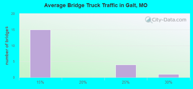
- 969Total average daily truck traffic
- 8,617Total future (year 2040) average daily traffic
- National Bridge Inventory (NBI) Registered Bridges for Galt
- No street view available for this location
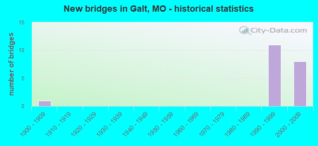
- New bridges - historical statistics
- 11900-1909
- 111990-1999
- 82000-2009
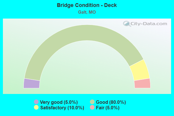
- Bridge Condition - Deck
- 5.0%Very good
- 80.0%Good
- 10.0%Satisfactory
- 5.0%Fair

- Bridge Condition - Superstructure
- 10.0%Excellent
- 10.0%Very good
- 40.0%Good
- 30.0%Satisfactory
- 10.0%Fair
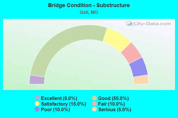
- Bridge Condition - Substructure
- 5.0%Excellent
- 55.0%Good
- 15.0%Satisfactory
- 10.0%Fair
- 10.0%Poor
- 5.0%Serious
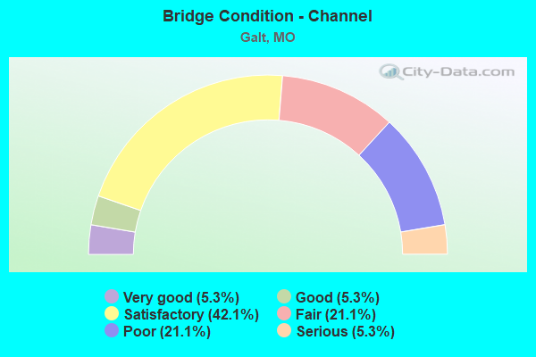
- Bridge Condition - Channel
- 5.3%Very good
- 5.3%Good
- 42.1%Satisfactory
- 21.1%Fair
- 21.1%Poor
- 5.3%Serious
Find on map >> Show street view
Structure Number: 11967, Location: S 33 T 62 N R 22 W (Lat: 40.131139, Lng: -93.381303), Route carried "on" structure: State highway 6, Year Built: 2000, Status: Open, Structure Length: 4.24m (13.91ft), Average Daily Traffic: 1,174 (year 2021), Truck Traffic: 20%, Average Future Daily Traffic: 2,055 (year 2041), Design Load: HS 20, Features Intersected: LIT MEDICINE CR OV
Minimum Vertical Clearance: 30+ m (98+ ft), Kilometerpoint: 147.625, Lanes on structure: 2, Base Highway Network: Yes, Owner: State Highway Agency, Approaching Roadway Width: 7.0m (23.0ft), Skew: 3 degrees, Material/Design: Prestressed concrete continuous, Design/Construction: Stringer/Multi-beam, Number Of Spans In Main Unit: 3, Length of Maximum Span: 14.2m (46.6ft), Curb-To-Curb Width: 10.8m (35.4ft), Out-to-Out Width: 11.6m (38.1ft)
Condition: Deck: Good, Superstructure: Excellent, Substructure: Excellent, Channel: Good, Operating Rating: 63.0 metric tons, Method Used To Determine Operating Rating: Load Factor (LF), Inventory Rating: 37.8 metric tons, Method Used To Determine Inventory Rating: Load Factor (LF), Structural Evaluation: Superior to present desirable criteria, Deck Geometry: Equal to present minimum criteria, Waterway Adequacy: Equal to present desirable criteria, Approach Roadway Alignment: Equal to present desirable criteria, Designated Inspection Frequency: Every 24 months, Inspection Date: October 2021, Deck Structure Type: Concrete Cast-file-Place, Wearing Surface/Protective System: Wearing Surface: Monolithic Concrete, Deck Protection: Other Coated Reinforcing
Find on map >> Show street view
Structure Number: 11968, Location: S 33 T 62 N R 22 W (Lat: 40.130722, Lng: -93.379228), Route carried "on" structure: State highway 6, Year Built: 2000, Status: Open, Structure Length: 11.03m (36.19ft), Average Daily Traffic: 1,174 (year 2021), Truck Traffic: 20%, Average Future Daily Traffic: 2,055 (year 2041), Design Load: HS 20, Features Intersected: LIT MEDICINE CR
Minimum Vertical Clearance: 30+ m (98+ ft), Kilometerpoint: 147.773, Lanes on structure: 2, Base Highway Network: Yes, Owner: State Highway Agency, Approaching Roadway Width: 7.0m (23.0ft), Material/Design: Prestressed concrete continuous, Design/Construction: Stringer/Multi-beam, Number Of Spans In Main Unit: 5, Length of Maximum Span: 30.0m (98.4ft), Curb-To-Curb Width: 10.8m (35.4ft), Out-to-Out Width: 11.6m (38.1ft)
Condition: Deck: Good, Superstructure: Excellent, Substructure: Good, Channel: Satisfactory, Operating Rating: 67.5 metric tons, Method Used To Determine Operating Rating: Load Factor (LF), Inventory Rating: 40.5 metric tons, Method Used To Determine Inventory Rating: Load Factor (LF), Structural Evaluation: Better than present minimum criteria, Deck Geometry: Equal to present minimum criteria, Waterway Adequacy: Superior to present desirable criteria, Approach Roadway Alignment: Equal to present desirable criteria, Designated Inspection Frequency: Every 24 months, Inspection Date: October 2021, Deck Structure Type: Concrete Cast-file-Place, Wearing Surface/Protective System: Wearing Surface: Monolithic Concrete, Deck Protection: Epoxy Coated Reinforcing
Find on map >> Show street view
Structure Number: 15173, Location: S 20 T 62 N R 22 W (Lat: 40.160697, Lng: -93.395472), Route carried "on" structure: County highway 87, Year Built: 1991, Status: Open, Structure Length: 0.91m (2.99ft), Average Daily Traffic: 20 (year 2020), Truck Traffic: 10%, Average Future Daily Traffic: 23 (year 2040), Features Intersected: UNNAMED STREAM, Facility Carried by Structure: NE 105TH ST
Minimum Vertical Clearance: 30+ m (98+ ft), Kilometerpoint: 2.092, Lanes on structure: 2, Owner: County Highway Agency, Approaching Roadway Width: 4.3m (14.1ft), Skew: 3 degrees, Material/Design: Steel, Design/Construction: Stringer/Multi-beam, Number Of Spans In Main Unit: 1, Length of Maximum Span: 8.8m (28.9ft), Curb-To-Curb Width: 6.1m (20.0ft), Out-to-Out Width: 6.1m (20.0ft)
Condition: Deck: Good, Superstructure: Good, Substructure: Poor, Channel: Poor, Operating Rating: 65.7 metric tons, Method Used To Determine Operating Rating: Allowable Stress (AS), Inventory Rating: 45.0 metric tons, Method Used To Determine Inventory Rating: Allowable Stress (AS), Structural Evaluation: Meets minimum limits, Deck Geometry: Somewhat better than minimum adequacy, Waterway Adequacy: Better than present minimum criteria, Approach Roadway Alignment: Equal to present desirable criteria, Length Of Structure Improvement: 0.16m (0.52ft), Designated Inspection Frequency: Every 24 months, Inspection Date: Febuary 2022, Bridge Improvement Cost: $78,000, Roadway Improvement Cost: $8,000, Total Project Cost: $118,000 ( Estimate for 2022), Deck Structure Type: Concrete Cast-file-Place, Wearing Surface/Protective System: Wearing Surface: Monolithic Concrete
Find on map >> Show street view
Structure Number: 15179, Location: S 20 T 62 N R 22 W (Lat: 40.155228, Lng: -93.395522), Route carried "on" structure: County highway 87, Year Built: 1991, Status: Open, Structure Length: 1.22m (4.00ft), Average Daily Traffic: 20 (year 2020), Truck Traffic: 10%, Average Future Daily Traffic: 23 (year 2040), Features Intersected: TRIB W FK MEDICINE, Facility Carried by Structure: NE 105TH ST
Minimum Vertical Clearance: 30+ m (98+ ft), Kilometerpoint: 2.736, Lanes on structure: 2, Owner: County Highway Agency, Approaching Roadway Width: 5.2m (17.1ft), Skew: 2 degrees, Material/Design: Steel, Design/Construction: Stringer/Multi-beam, Number Of Spans In Main Unit: 1, Length of Maximum Span: 11.9m (39.0ft), Curb-To-Curb Width: 6.1m (20.0ft), Out-to-Out Width: 6.2m (20.3ft)
Condition: Deck: Good, Superstructure: Satisfactory, Substructure: Fair, Channel: Fair, Operating Rating: 49.5 metric tons, Method Used To Determine Operating Rating: Allowable Stress (AS), Inventory Rating: 30.6 metric tons, Method Used To Determine Inventory Rating: Allowable Stress (AS), Structural Evaluation: Somewhat better than minimum adequacy, Deck Geometry: Somewhat better than minimum adequacy, Waterway Adequacy: Better than present minimum criteria, Approach Roadway Alignment: Equal to present desirable criteria, Designated Inspection Frequency: Every 24 months, Inspection Date: Febuary 2022, Deck Structure Type: Concrete Cast-file-Place, Wearing Surface/Protective System: Wearing Surface: Monolithic Concrete
Find on map >> Show street view
Structure Number: 15183, Location: S 29 T 62 N R 22 W (Lat: 40.146903, Lng: -93.395536), Route carried "on" structure: County highway 87, Year Built: 1991, Status: Open, Structure Length: 1.22m (4.00ft), Average Daily Traffic: 20 (year 2020), Truck Traffic: 10%, Average Future Daily Traffic: 23 (year 2040), Features Intersected: TRIB W FK MEDICINE, Facility Carried by Structure: NE 105TH ST
Minimum Vertical Clearance: 30+ m (98+ ft), Kilometerpoint: 3.541, Lanes on structure: 2, Owner: County Highway Agency, Approaching Roadway Width: 4.9m (16.1ft), Material/Design: Steel, Design/Construction: Stringer/Multi-beam, Number Of Spans In Main Unit: 1, Length of Maximum Span: 11.9m (39.0ft), Curb-To-Curb Width: 6.1m (20.0ft), Out-to-Out Width: 6.2m (20.3ft)
Condition: Deck: Good, Superstructure: Satisfactory, Substructure: Poor, Channel: Poor, Operating Rating: 51.3 metric tons, Method Used To Determine Operating Rating: Allowable Stress (AS), Inventory Rating: 34.2 metric tons, Method Used To Determine Inventory Rating: Allowable Stress (AS), Structural Evaluation: Meets minimum limits, Deck Geometry: Somewhat better than minimum adequacy, Waterway Adequacy: Better than present minimum criteria, Approach Roadway Alignment: Better than present minimum criteria, Length Of Structure Improvement: 0.19m (0.62ft), Designated Inspection Frequency: Every 24 months, Inspection Date: Febuary 2022, Bridge Improvement Cost: $94,000, Roadway Improvement Cost: $9,000, Total Project Cost: $140,000 ( Estimate for 2022), Deck Structure Type: Concrete Cast-file-Place, Wearing Surface/Protective System: Wearing Surface: Monolithic Concrete
Find on map >> Show street view
Structure Number: 15184, Location: S 29 T 62 N R 22 W (Lat: 40.141875, Lng: -93.395589), Route carried "on" structure: County highway 87, Year Built: 1991, Status: Open, Structure Length: 1.52m (4.99ft), Average Daily Traffic: 20 (year 2020), Truck Traffic: 10%, Average Future Daily Traffic: 23 (year 2040), Features Intersected: TRIB W FK MEDICINE, Facility Carried by Structure: NE 105TH ST
Minimum Vertical Clearance: 30+ m (98+ ft), Kilometerpoint: 4.023, Lanes on structure: 2, Owner: County Highway Agency, Approaching Roadway Width: 5.5m (18.0ft), Material/Design: Steel, Design/Construction: Stringer/Multi-beam, Number Of Spans In Main Unit: 1, Length of Maximum Span: 14.9m (48.9ft), Curb-To-Curb Width: 6.1m (20.0ft), Out-to-Out Width: 6.2m (20.3ft)
Condition: Deck: Good, Superstructure: Satisfactory, Substructure: Satisfactory, Channel: Poor, Operating Rating: 40.5 metric tons, Method Used To Determine Operating Rating: Allowable Stress (AS), Inventory Rating: 26.1 metric tons, Method Used To Determine Inventory Rating: Allowable Stress (AS), Structural Evaluation: Equal to present minimum criteria, Deck Geometry: Somewhat better than minimum adequacy, Waterway Adequacy: Better than present minimum criteria, Approach Roadway Alignment: Equal to present minimum criteria, Designated Inspection Frequency: Every 24 months, Inspection Date: Febuary 2022, Deck Structure Type: Concrete Cast-file-Place, Wearing Surface/Protective System: Wearing Surface: Monolithic Concrete
Find on map >> Show street view
Structure Number: 15364, Location: S 19 T 62 N R 22 W (Lat: 40.158933, Lng: -93.405083), Route carried "on" structure: County highway 92, Year Built: 1994, Status: Open, Structure Length: 1.22m (4.00ft), Average Daily Traffic: 5 (year 2020), Truck Traffic: 10%, Average Future Daily Traffic: 6 (year 2040), Features Intersected: W FK MEDICINE CR, Facility Carried by Structure: NE 100TH AVE
Minimum Vertical Clearance: 30+ m (98+ ft), Kilometerpoint: 0.966, Lanes on structure: 2, Owner: County Highway Agency, Approaching Roadway Width: 6.1m (20.0ft), Material/Design: Steel, Design/Construction: Stringer/Multi-beam, Number Of Spans In Main Unit: 1, Length of Maximum Span: 11.9m (39.0ft), Curb-To-Curb Width: 6.1m (20.0ft), Out-to-Out Width: 6.3m (20.7ft)
Condition: Deck: Good, Superstructure: Satisfactory, Substructure: Satisfactory, Channel: Fair, Operating Rating: 62.1 metric tons, Method Used To Determine Operating Rating: Allowable Stress (AS), Inventory Rating: 40.5 metric tons, Method Used To Determine Inventory Rating: Allowable Stress (AS), Structural Evaluation: Equal to present minimum criteria, Deck Geometry: Somewhat better than minimum adequacy, Waterway Adequacy: Better than present minimum criteria, Approach Roadway Alignment: Equal to present minimum criteria, Designated Inspection Frequency: Every 24 months, Inspection Date: Febuary 2022, Deck Structure Type: Concrete Cast-file-Place, Wearing Surface/Protective System: Wearing Surface: Monolithic Concrete
Find on map >> Show street view
Structure Number: 15727, Location: S 24 T 62 N R 23 W (Lat: 40.160556, Lng: -93.442397), Route carried "on" structure: County highway 97, Year Built: 1997, Status: Open, Structure Length: 0.91m (2.99ft), Average Daily Traffic: 20 (year 2020), Truck Traffic: 25%, Average Future Daily Traffic: 23 (year 2040), Features Intersected: BR OF NO CR, Facility Carried by Structure: NE 80TH AVE.
Minimum Vertical Clearance: 30+ m (98+ ft), Kilometerpoint: 2.414, Lanes on structure: 2, Owner: County Highway Agency, Approaching Roadway Width: 6.1m (20.0ft), Material/Design: Steel, Design/Construction: Stringer/Multi-beam, Number Of Spans In Main Unit: 1, Length of Maximum Span: 8.8m (28.9ft), Curb-To-Curb Width: 6.1m (20.0ft), Out-to-Out Width: 6.3m (20.7ft)
Condition: Deck: Good, Superstructure: Good, Substructure: Fair, Channel: Fair, Inventory Rating: 79.2 metric tons, Method Used To Determine Inventory Rating: Load Factor (LF), Structural Evaluation: Somewhat better than minimum adequacy, Deck Geometry: Somewhat better than minimum adequacy, Waterway Adequacy: Equal to present minimum criteria, Approach Roadway Alignment: Equal to present minimum criteria, Designated Inspection Frequency: Every 24 months, Inspection Date: Febuary 2022, Deck Structure Type: Concrete Cast-file-Place
Find on map >> Show street view
Structure Number: 20878, Location: S 7 T 61 N R 22 W (Lat: 40.090978, Lng: -93.414128), Route carried "on" structure: County highway 278, Year Built: 1997, Status: Open, Structure Length: 1.28m (4.20ft), Average Daily Traffic: 35 (year 2020), Truck Traffic: 10%, Average Future Daily Traffic: 40 (year 2040), Features Intersected: BLACK OAK BR, Facility Carried by Structure: NE 10TH ST
Minimum Vertical Clearance: 30+ m (98+ ft), Kilometerpoint: 2.414, Lanes on structure: 2, Owner: County Highway Agency, Approaching Roadway Width: 6.4m (21.0ft), Material/Design: Steel, Design/Construction: Stringer/Multi-beam, Number Of Spans In Main Unit: 1, Length of Maximum Span: 12.5m (41.0ft), Curb-To-Curb Width: 6.0m (19.7ft), Out-to-Out Width: 6.2m (20.3ft)
Condition: Deck: Good, Superstructure: Fair, Substructure: Good, Channel: Satisfactory, Operating Rating: 68.4 metric tons, Method Used To Determine Operating Rating: Load Factor (LF), Inventory Rating: 40.5 metric tons, Method Used To Determine Inventory Rating: Load Factor (LF), Structural Evaluation: Somewhat better than minimum adequacy, Deck Geometry: Meets minimum limits, Waterway Adequacy: Equal to present desirable criteria, Approach Roadway Alignment: Equal to present minimum criteria, Designated Inspection Frequency: Every 24 months, Inspection Date: Febuary 2022, Deck Structure Type: Concrete Cast-file-Place
Find on map >> Show street view
Structure Number: 20914, Location: S 9 T 61 N R 22 W (Lat: 40.091506, Lng: -93.384825), Route carried "on" structure: County highway 280, Year Built: 1993, Status: Open, Structure Length: 7.01m (23.00ft), Average Daily Traffic: 25 (year 2020), Truck Traffic: 10%, Average Future Daily Traffic: 29 (year 2040), Design Load: HS 20, Features Intersected: MEDICINE CR, Facility Carried by Structure: NE 10TH ST
Minimum Vertical Clearance: 3.63m (11.91ft), Kilometerpoint: 0.161, Lanes on structure: 2, Owner: County Highway Agency, Approaching Roadway Width: 6.7m (22.0ft), Skew: 2 degrees, Material/Design: Prestressed concrete, Design/Construction: Stringer/Multi-beam, Number Of Spans In Main Unit: 3, Length of Maximum Span: 27.4m (89.9ft), Curb-To-Curb Width: 7.3m (24.0ft), Out-to-Out Width: 7.5m (24.6ft)
Condition: Deck: Satisfactory, Superstructure: Satisfactory, Substructure: Satisfactory, Channel: Poor, Operating Rating: 54.0 metric tons, Method Used To Determine Operating Rating: Allowable Stress (AS), Inventory Rating: 32.4 metric tons, Method Used To Determine Inventory Rating: Allowable Stress (AS), Structural Evaluation: Equal to present minimum criteria, Deck Geometry: High priority of corrective action, Waterway Adequacy: Better than present minimum criteria, Approach Roadway Alignment: Equal to present minimum criteria, Designated Inspection Frequency: Every 24 months, Inspection Date: Febuary 2022, Deck Structure Type: Concrete Cast-file-Place, Wearing Surface/Protective System: Wearing Surface: Monolithic Concrete
Find on map >> Show street view
Structure Number: 28161, Location: S 12 T 61 N R 23 W (Lat: 40.091039, Lng: -93.422564), Route carried "on" structure: County highway 278, Year Built: 1997, Status: Open, Structure Length: 1.22m (4.00ft), Average Daily Traffic: 35 (year 2020), Truck Traffic: 10%, Average Future Daily Traffic: 40 (year 2040), Features Intersected: BLACK OAK BR, Facility Carried by Structure: NE 10TH ST
Minimum Vertical Clearance: 30+ m (98+ ft), Kilometerpoint: 1.609, Lanes on structure: 2, Owner: County Highway Agency, Approaching Roadway Width: 6.1m (20.0ft), Material/Design: Steel, Design/Construction: Stringer/Multi-beam, Number Of Spans In Main Unit: 1, Length of Maximum Span: 11.9m (39.0ft), Curb-To-Curb Width: 6.1m (20.0ft), Out-to-Out Width: 6.3m (20.7ft)
Condition: Deck: Good, Superstructure: Fair, Substructure: Good, Channel: Satisfactory, Operating Rating: 72.9 metric tons, Method Used To Determine Operating Rating: Load Factor (LF), Inventory Rating: 44.1 metric tons, Method Used To Determine Inventory Rating: Load Factor (LF), Structural Evaluation: Somewhat better than minimum adequacy, Deck Geometry: Somewhat better than minimum adequacy, Waterway Adequacy: Equal to present desirable criteria, Approach Roadway Alignment: Equal to present minimum criteria, Designated Inspection Frequency: Every 24 months, Inspection Date: Febuary 2022, Deck Structure Type: Concrete Cast-file-Place
Find on map >> Show street view
Structure Number: 31473, Location: S 19 T 62 N R 22 W (Lat: 40.149000, Lng: -93.406458), Route carried "on" structure: County highway , Year Built: 2005, Status: Open, Structure Length: 1.83m (6.00ft), Average Daily Traffic: 15 (year 2020), Truck Traffic: 10%, Average Future Daily Traffic: 17 (year 2040), Features Intersected: BR MEDICINE CR, Facility Carried by Structure: NE 45TH ST
Minimum Vertical Clearance: 30+ m (98+ ft), Kilometerpoint: 0.000, Lanes on structure: 2, Owner: County Highway Agency, Approaching Roadway Width: 6.1m (20.0ft), Material/Design: Steel, Design/Construction: Stringer/Multi-beam, Number Of Spans In Main Unit: 1, Length of Maximum Span: 18.0m (59.1ft), Curb-To-Curb Width: 7.4m (24.3ft), Out-to-Out Width: 7.6m (24.9ft)
Condition: Deck: Good, Superstructure: Good, Substructure: Good, Channel: Satisfactory, Operating Rating: 41.4 metric tons, Method Used To Determine Operating Rating: Load Factor (LF), Inventory Rating: 25.2 metric tons, Method Used To Determine Inventory Rating: Load Factor (LF), Structural Evaluation: Equal to present minimum criteria, Deck Geometry: Equal to present minimum criteria, Waterway Adequacy: Better than present minimum criteria, Approach Roadway Alignment: Equal to present desirable criteria, Designated Inspection Frequency: Every 24 months, Inspection Date: Febuary 2022, Deck Structure Type: Concrete Cast-file-Place
Find on map >> Show street view
Structure Number: 31474, Location: S 36 T 62 N R 23 W (Lat: 40.120556, Lng: -93.442392), Route carried "on" structure: County highway , Year Built: 2005, Status: Open, Structure Length: 1.52m (4.99ft), Average Daily Traffic: 25 (year 2020), Truck Traffic: 10%, Average Future Daily Traffic: 29 (year 2040), Features Intersected: BR NO CR, Facility Carried by Structure: NE 80TH AVE
Minimum Vertical Clearance: 30+ m (98+ ft), Kilometerpoint: 0.000, Lanes on structure: 2, Owner: County Highway Agency, Approaching Roadway Width: 6.1m (20.0ft), Material/Design: Steel, Design/Construction: Stringer/Multi-beam, Number Of Spans In Main Unit: 1, Length of Maximum Span: 14.9m (48.9ft), Curb-To-Curb Width: 7.4m (24.3ft), Out-to-Out Width: 7.6m (24.9ft)
Condition: Deck: Good, Superstructure: Good, Substructure: Good, Channel: Fair, Operating Rating: 59.4 metric tons, Method Used To Determine Operating Rating: Load Factor (LF), Inventory Rating: 36.0 metric tons, Method Used To Determine Inventory Rating: Load Factor (LF), Structural Evaluation: Better than present minimum criteria, Deck Geometry: Equal to present minimum criteria, Waterway Adequacy: Better than present minimum criteria, Approach Roadway Alignment: Equal to present minimum criteria, Designated Inspection Frequency: Every 24 months, Inspection Date: Febuary 2022, Deck Structure Type: Concrete Cast-file-Place
Find on map >> Show street view
Structure Number: 31476, Location: S 26 T 62 N R 23 W (Lat: 40.134144, Lng: -93.442206), Route carried "on" structure: County highway , Year Built: 2004, Status: Open, Structure Length: 1.53m (5.02ft), Average Daily Traffic: 25 (year 2020), Truck Traffic: 10%, Average Future Daily Traffic: 29 (year 2040), Features Intersected: BR NO CR, Facility Carried by Structure: NE 40TH ST
Minimum Vertical Clearance: 30+ m (98+ ft), Kilometerpoint: 0.000, Lanes on structure: 2, Owner: County Highway Agency, Approaching Roadway Width: 6.1m (20.0ft), Material/Design: Steel, Design/Construction: Stringer/Multi-beam, Number Of Spans In Main Unit: 1, Length of Maximum Span: 15.0m (49.2ft), Curb-To-Curb Width: 7.4m (24.3ft), Out-to-Out Width: 7.6m (24.9ft)
Condition: Deck: Very good, Superstructure: Good, Substructure: Good, Channel: Satisfactory, Operating Rating: 90.0 metric tons, Method Used To Determine Operating Rating: Load Factor (LF), Inventory Rating: 54.0 metric tons, Method Used To Determine Inventory Rating: Load Factor (LF), Structural Evaluation: Better than present minimum criteria, Deck Geometry: Equal to present minimum criteria, Waterway Adequacy: Better than present minimum criteria, Approach Roadway Alignment: Equal to present desirable criteria, Designated Inspection Frequency: Every 24 months, Inspection Date: Febuary 2022, Deck Structure Type: Concrete Cast-file-Place
Find on map >> Show street view
Structure Number: 31477, Location: S 35 T 62 N R 23 W (Lat: 40.122617, Lng: -93.461408), Route carried "on" structure: County highway , Year Built: 2005, Status: Open, Structure Length: 1.54m (5.05ft), Average Daily Traffic: 20 (year 2020), Truck Traffic: 10%, Average Future Daily Traffic: 23 (year 2040), Features Intersected: BR NO CR, Facility Carried by Structure: NE 30TH ST
Minimum Vertical Clearance: 30+ m (98+ ft), Kilometerpoint: 0.000, Lanes on structure: 2, Owner: County Highway Agency, Approaching Roadway Width: 6.1m (20.0ft), Material/Design: Steel, Design/Construction: Stringer/Multi-beam, Number Of Spans In Main Unit: 1, Length of Maximum Span: 15.1m (49.5ft), Curb-To-Curb Width: 7.4m (24.3ft), Out-to-Out Width: 7.6m (24.9ft)
Condition: Deck: Good, Superstructure: Good, Substructure: Good, Channel: Satisfactory, Operating Rating: 88.2 metric tons, Method Used To Determine Operating Rating: Load Factor (LF), Inventory Rating: 53.1 metric tons, Method Used To Determine Inventory Rating: Load Factor (LF), Structural Evaluation: Better than present minimum criteria, Deck Geometry: Equal to present minimum criteria, Waterway Adequacy: Better than present minimum criteria, Approach Roadway Alignment: Equal to present desirable criteria, Designated Inspection Frequency: Every 24 months, Inspection Date: Febuary 2022, Deck Structure Type: Concrete Cast-file-Place
Find on map >> Show street view
Structure Number: 31522, Location: S 17 T 62 N R 22 W (Lat: 40.167244, Lng: -93.404581), Route carried "on" structure: County highway 91, Year Built: 1900, Status: Closed, Structure Length: 0.61m (2.00ft), Average Daily Traffic: 5 (year 2020), Truck Traffic: 10%, Average Future Daily Traffic: 6 (year 2040), Features Intersected: BR W FK MEDICINE C, Facility Carried by Structure: NE 62ND ST
Minimum Vertical Clearance: 30+ m (98+ ft), Kilometerpoint: 0.000, Lanes on structure: 1, Owner: County Highway Agency, Approaching Roadway Width: 4.4m (14.4ft), Material/Design: Steel, Design/Construction: Stringer/Multi-beam, Number Of Spans In Main Unit: 1, Length of Maximum Span: 5.8m (19.0ft), Curb-To-Curb Width: 4.4m (14.4ft), Out-to-Out Width: 4.4m (14.4ft)
Condition: Deck: Fair, Superstructure: Satisfactory, Substructure: Serious, Channel: Serious, Deck Geometry: Equal to present minimum criteria, Waterway Adequacy: Better than present minimum criteria, Approach Roadway Alignment: Equal to present minimum criteria, Bridge Posting: Required (Relationship of Operating Rating to Maximum Legal Load: > 39.9% below), Length Of Structure Improvement: 0.12m (0.39ft), Designated Inspection Frequency: Every 24 months, Inspection Date: Febuary 2022, Bridge Improvement Cost: $87,000, Roadway Improvement Cost: $9,000, Total Project Cost: $130,000 ( Estimate for 2022), Deck Structure Type: Wood or Timber
Find on map >> Show street view
Structure Number: 32303, Location: S 12 T 61 N R 23 W (Lat: 40.090589, Lng: -93.436172), Route carried "on" structure: County highway 278, Year Built: 2007, Status: Open, Structure Length: 1.22m (4.00ft), Average Daily Traffic: 35 (year 2020), Truck Traffic: 10%, Average Future Daily Traffic: 40 (year 2040), Features Intersected: BLACK OAK BR, Facility Carried by Structure: NE 10TH ST
Minimum Vertical Clearance: 30+ m (98+ ft), Kilometerpoint: 0.000, Lanes on structure: 2, Owner: County Highway Agency, Approaching Roadway Width: 6.1m (20.0ft), Material/Design: Steel, Design/Construction: Stringer/Multi-beam, Number Of Spans In Main Unit: 1, Length of Maximum Span: 12.2m (40.0ft), Curb-To-Curb Width: 7.3m (24.0ft), Out-to-Out Width: 7.6m (24.9ft)
Condition: Deck: Good, Superstructure: Very good, Substructure: Good, Channel: Satisfactory, Inventory Rating: 62.1 metric tons, Method Used To Determine Inventory Rating: Load Factor (LF), Structural Evaluation: Better than present minimum criteria, Deck Geometry: Equal to present minimum criteria, Waterway Adequacy: Better than present minimum criteria, Approach Roadway Alignment: Equal to present desirable criteria, Designated Inspection Frequency: Every 24 months, Inspection Date: Febuary 2022, Deck Structure Type: Concrete Cast-file-Place
Find on map >> Show street view
Structure Number: 33048, Location: S 35 T 62 N R 23 W (Lat: 40.126894, Lng: -93.447056), Route carried "on" structure: County highway 110, Year Built: 2009, Status: Open, Structure Length: 1.52m (4.99ft), Average Daily Traffic: 20 (year 2020), Truck Traffic: 10%, Average Future Daily Traffic: 23 (year 2040), Features Intersected: STREAM, Facility Carried by Structure: NE 30TH ST
Minimum Vertical Clearance: 30+ m (98+ ft), Kilometerpoint: 0.000, Lanes on structure: 2, Owner: County Highway Agency, Approaching Roadway Width: 6.1m (20.0ft), Material/Design: Steel, Design/Construction: Stringer/Multi-beam, Number Of Spans In Main Unit: 1, Length of Maximum Span: 15.2m (49.9ft), Curb-To-Curb Width: 7.3m (24.0ft), Out-to-Out Width: 7.5m (24.6ft)
Condition: Deck: Good, Superstructure: Good, Substructure: Good, Channel: Satisfactory, Operating Rating: 89.1 metric tons, Method Used To Determine Operating Rating: Load Factor (LF), Inventory Rating: 53.1 metric tons, Method Used To Determine Inventory Rating: Load Factor (LF), Structural Evaluation: Better than present minimum criteria, Deck Geometry: Equal to present minimum criteria, Waterway Adequacy: Better than present minimum criteria, Approach Roadway Alignment: Equal to present desirable criteria, Designated Inspection Frequency: Every 24 months, Inspection Date: Febuary 2022, Deck Structure Type: Concrete Cast-file-Place, Wearing Surface/Protective System: Wearing Surface: Monolithic Concrete
Find on map >> Show street view
Structure Number: 4176, Location: S 34 T 62 N R 22 W (Lat: 40.129719, Lng: -93.362956), Route carried "on" structure: State highway 6, Year Built: 1995, Status: Open, Structure Length: 17.68m (58.01ft), Average Daily Traffic: 1,174 (year 2021), Truck Traffic: 20%, Average Future Daily Traffic: 2,055 (year 2041), Design Load: HS 20, Features Intersected: MEDICINE CR
Minimum Vertical Clearance: 30+ m (98+ ft), Kilometerpoint: 149.188, Lanes on structure: 2, Base Highway Network: Yes, Owner: State Highway Agency, Approaching Roadway Width: 11.0m (36.1ft), Skew: 5 degrees, Material/Design: Prestressed concrete continuous, Design/Construction: Tee Beam, Number Of Spans In Main Unit: 6, Length of Maximum Span: 36.6m (120.1ft), Curb or Sidewalk Widths: Left: 0.2m (0.7ft), Right: 0.2m (0.7ft), Curb-To-Curb Width: 10.6m (34.8ft), Out-to-Out Width: 11.4m (37.4ft)
Condition: Deck: Satisfactory, Superstructure: Good, Substructure: Good, Channel: Very good, Operating Rating: 53.1 metric tons, Method Used To Determine Operating Rating: Load Factor (LF), Inventory Rating: 31.5 metric tons, Method Used To Determine Inventory Rating: Load Factor (LF), Structural Evaluation: Better than present minimum criteria, Deck Geometry: Equal to present minimum criteria, Waterway Adequacy: Equal to present desirable criteria, Approach Roadway Alignment: Equal to present desirable criteria, Designated Inspection Frequency: Every 24 months, Inspection Date: August 2021, Deck Structure Type: Concrete Cast-file-Place, Wearing Surface/Protective System: Wearing Surface: Monolithic Concrete, Deck Protection: Epoxy Coated Reinforcing
Find on map >> Show street view
Structure Number: 4177, Location: S 34 T 62 N R 22 W (Lat: 40.128633, Lng: -93.366011), Route carried "on" structure: State highway 6, Year Built: 1995, Status: Open, Structure Length: 7.92m (25.98ft), Average Daily Traffic: 1,174 (year 2021), Truck Traffic: 20%, Average Future Daily Traffic: 2,055 (year 2041), Design Load: HS 20, Features Intersected: IMRL RR
Minimum Vertical Clearance: 30+ m (98+ ft), Kilometerpoint: 148.948, Lanes on structure: 2, Base Highway Network: Yes, Owner: State Highway Agency, Approaching Roadway Width: 11.0m (36.1ft), Skew: 4 degrees, Material/Design: Prestressed concrete continuous, Design/Construction: Stringer/Multi-beam, Number Of Spans In Main Unit: 3, Length of Maximum Span: 26.6m (87.3ft), Curb or Sidewalk Widths: Left: 0.2m (0.7ft), Right: 0.2m (0.7ft), Curb-To-Curb Width: 10.6m (34.8ft), Out-to-Out Width: 12.6m (41.3ft)
Condition: Deck: Good, Superstructure: Very good, Substructure: Good, Operating Rating: 63.9 metric tons, Method Used To Determine Operating Rating: Load Factor (LF), Inventory Rating: 38.7 metric tons, Method Used To Determine Inventory Rating: Load Factor (LF), Structural Evaluation: Better than present minimum criteria, Deck Geometry: Equal to present minimum criteria, Underclear: Superior to present desirable criteria, Approach Roadway Alignment: Equal to present desirable criteria, Designated Inspection Frequency: Every 24 months, Inspection Date: August 2021, Deck Structure Type: Concrete Cast-file-Place, Wearing Surface/Protective System: Wearing Surface: Monolithic Concrete, Deck Protection: Epoxy Coated Reinforcing