Bridge Statistics for Gardendale, Alabama (AL)
Condition, Traffic, Stress, Structural Evaluation, Project Costs
- National Bridge Inventory (NBI) Statistics
- 22Number of bridges
- 236ft / 72.1mTotal length
- $30,405,000Total costs
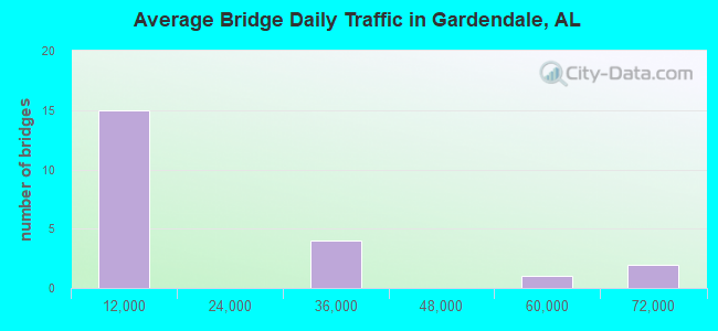
- 332,074Total average daily traffic
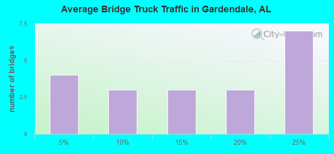
- 63,707Total average daily truck traffic
- National Bridge Inventory (NBI) Registered Bridges for Gardendale
- No street view available for this location
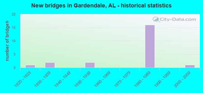
- New bridges - historical statistics
- 11920-1929
- 21930-1939
- 21950-1959
- 161980-1989
- 12000-2009
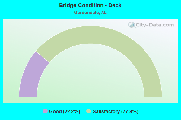
- Bridge Condition - Deck
- 22.2%Good
- 77.8%Satisfactory
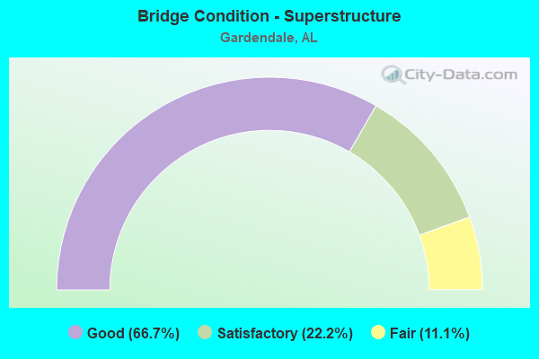
- Bridge Condition - Superstructure
- 66.7%Good
- 22.2%Satisfactory
- 11.1%Fair
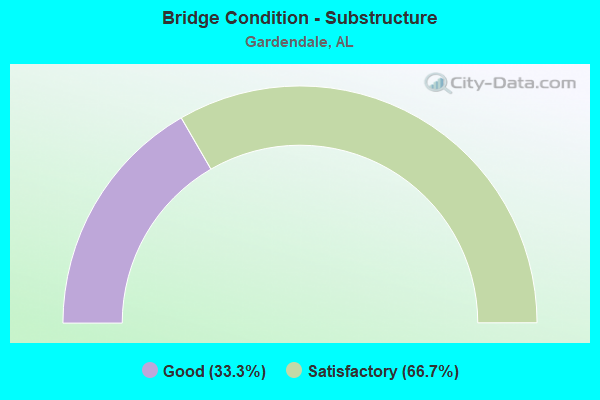
- Bridge Condition - Substructure
- 33.3%Good
- 66.7%Satisfactory
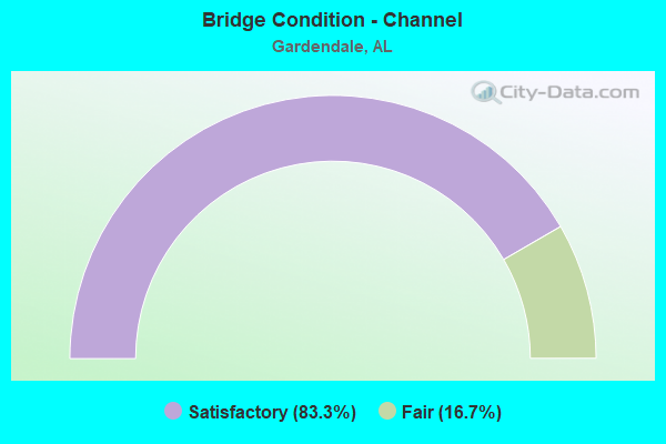
- Bridge Condition - Channel
- 83.3%Satisfactory
- 16.7%Fair
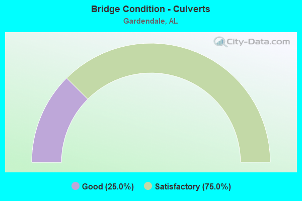
- Bridge Condition - Culverts
- 25.0%Good
- 75.0%Satisfactory
Find on map >> Show street view
Structure Number: 1318, Location: 1 MI E STATE21 ON CO 128 (Lat: 33.568769, Lng: -85.864356), Route carried "on" structure: County highway 128, Year Built: 1935, Status: Posted for load, Structure Length: 2.10m (6.89ft), Average Daily Traffic: 523 (year 2020), Truck Traffic: 5%, Average Future Daily Traffic: 585 (year 2040), Design Load: HS 20, Features Intersected: DRY BRCH TO CHOCCOLOCCO
Minimum Vertical Clearance: 30+ m (98+ ft), Kilometerpoint: 0.010, Lanes on structure: 2, Owner: County Highway Agency, Approaching Roadway Width: 6.7m (22.0ft), Material/Design: Concrete, Design/Construction: Tee Beam, Number Of Spans In Main Unit: 2, Length of Maximum Span: 10.7m (35.1ft), Curb or Sidewalk Widths: Left: 0.1m (0.3ft), Right: 0.1m (0.3ft), Curb-To-Curb Width: 5.5m (18.0ft), Out-to-Out Width: 6.2m (20.3ft)
Condition: Deck: Good, Superstructure: Good, Substructure: Satisfactory, Channel: Satisfactory, Operating Rating: 33.5 metric tons, Method Used To Determine Operating Rating: Load Factor (LF), Inventory Rating: 20.1 metric tons, Method Used To Determine Inventory Rating: Load Factor (LF), Structural Evaluation: Somewhat better than minimum adequacy, Deck Geometry: High priority of replacement, Waterway Adequacy: Better than present minimum criteria, Approach Roadway Alignment: Better than present minimum criteria, Bridge Posting: Required (Relationship of Operating Rating to Maximum Legal Load: 30.0 - 39.9% below), Length Of Structure Improvement: 2.88m (9.45ft), Designated Inspection Frequency: Every 24 months, Other Special Inspection Frequency: Every 12 months, Inspection Date: January 2022, Other Special Inspection Date: January 2022, Bridge Improvement Cost: $394,000, Roadway Improvement Cost: $39,000, Total Project Cost: $433,000 ( Estimate for 2022), Deck Structure Type: Concrete Cast-file-Place, Wearing Surface/Protective System: Wearing Surface: Bituminous
Find on map >> Show street view
Structure Number: 1853, Location: 1.5 MILES N NEW CASTLE (Lat: 33.665467, Lng: -86.758917), Route carried "on" structure: County highway 224, Year Built: 1938, Status: Open, Structure Length: 1.45m (4.76ft), Average Daily Traffic: 1,798 (year 2018), Truck Traffic: 12%, Average Future Daily Traffic: 2,189 (year 2038), Design Load: H 15, Features Intersected: CUNNINGHAM CREEK, Facility Carried by Structure: NEW CASTLE RD
Minimum Vertical Clearance: 30+ m (98+ ft), Kilometerpoint: 0.010, Lanes on structure: 2, Owner: County Highway Agency, Approaching Roadway Width: 6.3m (20.7ft), Material/Design: Steel, Design/Construction: Culvert, Number Of Spans In Main Unit: 2, Length of Maximum Span: 7.2m (23.6ft), Curb-To-Curb Width: 7.6m (24.9ft), Out-to-Out Width: 8.7m (28.5ft)
Condition: Channel: Fair, Culverts: Satisfactory, Operating Rating: 43.7 metric tons, Method Used To Determine Operating Rating: Load Factor (LF), Inventory Rating: 32.7 metric tons, Method Used To Determine Inventory Rating: Load Factor (LF), Structural Evaluation: Equal to present minimum criteria, Deck Geometry: Meets minimum limits, Waterway Adequacy: Equal to present minimum criteria, Approach Roadway Alignment: Better than present minimum criteria, Length Of Structure Improvement: 2.12m (6.96ft), Designated Inspection Frequency: Every 24 months, Inspection Date: October 2020, Bridge Improvement Cost: $343,000, Roadway Improvement Cost: $34,000, Total Project Cost: $377,000 ( Estimate for 2022), Wearing Surface/Protective System: Wearing Surface: Bituminous
Find on map >> Show street view
Structure Number: 3916, Location: 1.5 MI S MOUNT OLIVE RD (Lat: 33.648269, Lng: -86.846350), Route carried "on" structure: County highway 251, Year Built: 1950, Status: Posted for load, Structure Length: 2.01m (6.59ft), Average Daily Traffic: 1,750 (year 2021), Truck Traffic: 4%, Average Future Daily Traffic: 2,095 (year 2041), Design Load: H 20, Features Intersected: NEW FOUND CREEK, Facility Carried by Structure: SHADY GROVE ROAD
Minimum Vertical Clearance: 30+ m (98+ ft), Kilometerpoint: 0.010, Lanes on structure: 2, Owner: County Highway Agency, Approaching Roadway Width: 6.3m (20.7ft), Skew: 4 degrees, Material/Design: Steel continuous, Design/Construction: Stringer/Multi-beam, Number Of Spans In Main Unit: 2, Length of Maximum Span: 9.5m (31.2ft), Curb or Sidewalk Widths: Left: 0.5m (1.6ft), Right: 0.5m (1.6ft), Curb-To-Curb Width: 7.2m (23.6ft), Out-to-Out Width: 8.9m (29.2ft)
Condition: Deck: Satisfactory, Superstructure: Satisfactory, Substructure: Satisfactory, Channel: Satisfactory, Operating Rating: 29.3 metric tons, Method Used To Determine Operating Rating: Load Factor (LF), Inventory Rating: 17.5 metric tons, Method Used To Determine Inventory Rating: Load Factor (LF), Structural Evaluation: Meets minimum limits, Deck Geometry: High priority of corrective action, Waterway Adequacy: Equal to present minimum criteria, Approach Roadway Alignment: Better than present minimum criteria, Bridge Posting: Required (Relationship of Operating Rating to Maximum Legal Load: 20.0 - 29.9% below), Length Of Structure Improvement: 2.77m (9.09ft), Designated Inspection Frequency: Every 24 months, Other Special Inspection Frequency: Every 12 months, Inspection Date: June 2021, Other Special Inspection Date: June 2021, Bridge Improvement Cost: $551,000, Roadway Improvement Cost: $55,000, Total Project Cost: $606,000 ( Estimate for 2022), Deck Structure Type: Concrete Cast-file-Place
Find on map >> Show street view
Structure Number: 12427, Location: JCT GINGER ST GARDENDALE (Lat: 33.660100, Lng: -86.819272), Route carried "on" structure: County highway 248, Year Built: 1980, Status: Open, Structure Length: 0.68m (2.23ft), Average Daily Traffic: 4,833 (year 2022), Truck Traffic: 5%, Average Future Daily Traffic: 6,725 (year 2042), Design Load: HS 20, Features Intersected: NEWFOUND CREEK, Facility Carried by Structure: MT OLIVE RD
Minimum Vertical Clearance: 30+ m (98+ ft), Kilometerpoint: 0.010, Lanes on structure: 2, Owner: County Highway Agency, Approaching Roadway Width: 7.3m (24.0ft), Skew: 1 degrees, Material/Design: Concrete, Design/Construction: Culvert, Number Of Spans In Main Unit: 2, Length of Maximum Span: 3.0m (9.8ft)
Condition: Channel: Satisfactory, Culverts: Satisfactory, Operating Rating: 58.9 metric tons, Method Used To Determine Operating Rating: Load Factor (LF), Inventory Rating: 35.3 metric tons, Method Used To Determine Inventory Rating: Load Factor (LF), Structural Evaluation: Equal to present minimum criteria, Waterway Adequacy: Equal to present minimum criteria, Approach Roadway Alignment: Better than present minimum criteria, Length Of Structure Improvement: 1.31m (4.30ft), Designated Inspection Frequency: Every 24 months, Inspection Date: January 2022, Bridge Improvement Cost: $520,000, Roadway Improvement Cost: $52,000, Total Project Cost: $572,000 ( Estimate for 2022)
Find on map >> Show street view
Structure Number: 12923, Location: GARDENDALE EXIT (Lat: 33.649900, Lng: -86.829600), Route carried "on" structure: Interstate 65, Year Built: 1983, Status: Open, Structure Length: 8.50m (27.89ft), Average Daily Traffic: 30,755 (year 2020), Truck Traffic: 20%, Average Future Daily Traffic: 38,964 (year 2040), Design Load: HS 20, Features Intersected: FIELDSTOWN ROAD
Minimum Vertical Clearance: 30+ m (98+ ft), Kilometerpoint: 435.102, Lanes on structure: 4, Lanes under structure: 4, Base Highway Network: Yes, Owner: State Highway Agency, Approaching Roadway Width: 18.9m (62.0ft), Skew: 6 degrees, Material/Design: Steel, Design/Construction: Stringer/Multi-beam, Number Of Spans In Main Unit: 1, Number Of Approach Spans: 3, Length of Maximum Span: 29.6m (97.1ft), Curb-To-Curb Width: 20.7m (67.9ft), Out-to-Out Width: 21.6m (70.9ft)
Condition: Deck: Satisfactory, Superstructure: Satisfactory, Substructure: Satisfactory, Operating Rating: 59.9 metric tons, Method Used To Determine Operating Rating: Allowable Stress (AS), Inventory Rating: 35.8 metric tons, Method Used To Determine Inventory Rating: Allowable Stress (AS), Structural Evaluation: Equal to present minimum criteria, Deck Geometry: Equal to present minimum criteria, Underclear: Superior to present desirable criteria, Approach Roadway Alignment: Equal to present desirable criteria, Length Of Structure Improvement: 9.49m (31.14ft), Designated Inspection Frequency: Every 24 months, Inspection Date: August 2020, Bridge Improvement Cost: $4,555,000, Roadway Improvement Cost: $456,000, Total Project Cost: $5,011,000 ( Estimate for 2022), Deck Structure Type: Concrete Cast-file-Place
Find on map >> Show street view
Structure Number: 12924, Location: GARDENDALE EXIT (Lat: 33.650000, Lng: -86.829300), Route carried "on" structure: Interstate 65, Year Built: 1983, Status: Open, Structure Length: 8.50m (27.89ft), Average Daily Traffic: 30,755 (year 2020), Truck Traffic: 20%, Average Future Daily Traffic: 38,964 (year 2040), Design Load: HS 20, Features Intersected: FIELDSTOWN ROAD
Minimum Vertical Clearance: 30+ m (98+ ft), Kilometerpoint: 435.102, Lanes on structure: 4, Lanes under structure: 4, Base Highway Network: Yes, Owner: State Highway Agency, Approaching Roadway Width: 18.9m (62.0ft), Skew: 6 degrees, Material/Design: Steel, Design/Construction: Stringer/Multi-beam, Number Of Spans In Main Unit: 1, Number Of Approach Spans: 3, Length of Maximum Span: 29.6m (97.1ft), Curb-To-Curb Width: 17.1m (56.1ft), Out-to-Out Width: 17.9m (58.7ft)
Condition: Deck: Satisfactory, Superstructure: Fair, Substructure: Satisfactory, Operating Rating: 58.7 metric tons, Method Used To Determine Operating Rating: Allowable Stress (AS), Inventory Rating: 32.9 metric tons, Method Used To Determine Inventory Rating: Allowable Stress (AS), Structural Evaluation: Somewhat better than minimum adequacy, Deck Geometry: Meets minimum limits, Underclear: Superior to present desirable criteria, Approach Roadway Alignment: Equal to present desirable criteria, Length Of Structure Improvement: 9.49m (31.14ft), Designated Inspection Frequency: Every 24 months, Inspection Date: August 2020, Bridge Improvement Cost: $3,775,000, Roadway Improvement Cost: $378,000, Total Project Cost: $4,153,000 ( Estimate for 2022), Deck Structure Type: Concrete Cast-file-Place
Find on map >> Show street view
Structure Number: 13179, Location: I65 * MT OLIVE RD (Lat: 33.671967, Lng: -86.830183), Route carried "on" structure: County highway , Year Built: 1984, Status: Open, Structure Length: 11.14m (36.55ft), Average Daily Traffic: 5,000 (year 2020), Truck Traffic: 2%, Average Future Daily Traffic: 6,500 (year 2040), Design Load: HS 20, Features Intersected: I65, Facility Carried by Structure: MT OLIVE RD
Minimum Vertical Clearance: 30+ m (98+ ft), Kilometerpoint: 0.010, Lanes on structure: 2, Lanes under structure: 7, Owner: State Highway Agency, Approaching Roadway Width: 15.2m (49.9ft), Material/Design: Steel continuous, Design/Construction: Stringer/Multi-beam, Number Of Spans In Main Unit: 4, Length of Maximum Span: 30.8m (101.0ft), Curb-To-Curb Width: 15.2m (49.9ft), Out-to-Out Width: 16.1m (52.8ft)
Condition: Deck: Satisfactory, Superstructure: Good, Substructure: Good, Operating Rating: 59.8 metric tons, Method Used To Determine Operating Rating: Load Factor (LF), Inventory Rating: 35.8 metric tons, Method Used To Determine Inventory Rating: Load Factor (LF), Structural Evaluation: Better than present minimum criteria, Deck Geometry: Superior to present desirable criteria, Underclear: Equal to present minimum criteria, Approach Roadway Alignment: Equal to present desirable criteria, Length Of Structure Improvement: 12.03m (39.47ft), Designated Inspection Frequency: Every 24 months, Inspection Date: July 2020, Bridge Improvement Cost: $4,289,000, Roadway Improvement Cost: $429,000, Total Project Cost: $4,718,000 ( Estimate for 2022), Deck Structure Type: Concrete Cast-file-Place
Find on map >> Show street view
Structure Number: 1318, Location: MT OLIVE RD * I65 (Lat: 33.672117, Lng: -86.830133), Route carried "on" structure: County highway , Year Built: 1984, Status: Open, Structure Length: 11.14m (36.55ft), Average Daily Traffic: 5,000 (year 2020), Truck Traffic: 1%, Average Future Daily Traffic: 6,500 (year 2040), Design Load: HS 20, Features Intersected: I 65, Facility Carried by Structure: MT OLIVE RD
Minimum Vertical Clearance: 30+ m (98+ ft), Kilometerpoint: 0.010, Lanes on structure: 3, Lanes under structure: 7, Owner: State Highway Agency, Approaching Roadway Width: 11.6m (38.1ft), Material/Design: Steel continuous, Design/Construction: Stringer/Multi-beam, Number Of Spans In Main Unit: 4, Length of Maximum Span: 30.8m (101.0ft), Curb-To-Curb Width: 11.6m (38.1ft), Out-to-Out Width: 12.5m (41.0ft)
Condition: Deck: Satisfactory, Superstructure: Good, Substructure: Good, Operating Rating: 73.0 metric tons, Method Used To Determine Operating Rating: Load Factor (LF), Inventory Rating: 43.7 metric tons, Method Used To Determine Inventory Rating: Load Factor (LF), Structural Evaluation: Better than present minimum criteria, Deck Geometry: High priority of replacement, Underclear: Equal to present minimum criteria, Approach Roadway Alignment: Better than present minimum criteria, Length Of Structure Improvement: 12.03m (39.47ft), Designated Inspection Frequency: Every 24 months, Inspection Date: July 2020, Bridge Improvement Cost: $3,382,000, Roadway Improvement Cost: $338,000, Total Project Cost: $3,720,000 ( Estimate for 2022), Deck Structure Type: Concrete Cast-file-Place
Find on map >> Show street view
Structure Number: 13529, Location: I65 * BEASLEY RD (Lat: 33.684836, Lng: -86.828794), Route carried "on" structure: County highway , Year Built: 1985, Status: Open, Structure Length: 9.51m (31.20ft), Average Daily Traffic: 1,200 (year 2020), Truck Traffic: 1%, Average Future Daily Traffic: 1,600 (year 2040), Design Load: HS 20, Features Intersected: I 65, Facility Carried by Structure: BEASLEY RD
Minimum Vertical Clearance: 30+ m (98+ ft), Kilometerpoint: 0.010, Lanes on structure: 2, Lanes under structure: 6, Owner: State Highway Agency, Approaching Roadway Width: 8.5m (27.9ft), Skew: 1 degrees, Material/Design: Prestressed concrete continuous, Design/Construction: Stringer/Multi-beam, Number Of Spans In Main Unit: 4, Length of Maximum Span: 27.4m (89.9ft), Curb-To-Curb Width: 8.4m (27.6ft), Out-to-Out Width: 9.4m (30.8ft)
Condition: Deck: Good, Superstructure: Good, Substructure: Good, Operating Rating: 88.9 metric tons, Method Used To Determine Operating Rating: Load Factor (LF), Inventory Rating: 55.0 metric tons, Method Used To Determine Inventory Rating: Load Factor (LF), Structural Evaluation: Better than present minimum criteria, Deck Geometry: Meets minimum limits, Underclear: Equal to present minimum criteria, Approach Roadway Alignment: Better than present minimum criteria, Length Of Structure Improvement: 10.46m (34.32ft), Designated Inspection Frequency: Every 24 months, Inspection Date: June 2020, Bridge Improvement Cost: $2,152,000, Roadway Improvement Cost: $215,000, Total Project Cost: $2,367,000 ( Estimate for 2022), Deck Structure Type: Concrete Cast-file-Place
Find on map >> Show street view
Structure Number: 1353, Location: MORRIS EXIT (Lat: 33.718247, Lng: -86.829189), Route carried "on" structure: Interstate 65, Year Built: 1985, Year Reconstructed: 2003, Status: Open, Structure Length: 7.86m (25.79ft), Average Daily Traffic: 29,415 (year 2020), Truck Traffic: 21%, Average Future Daily Traffic: 37,266 (year 2040), Design Load: HS 20, Features Intersected: BARBER BOULEVARD
Minimum Vertical Clearance: 30+ m (98+ ft), Kilometerpoint: 442.925, Lanes on structure: 3, Lanes under structure: 2, Base Highway Network: Yes, Owner: State Highway Agency, Approaching Roadway Width: 17.1m (56.1ft), Skew: 6 degrees, Material/Design: Steel, Design/Construction: Stringer/Multi-beam, Number Of Spans In Main Unit: 3, Length of Maximum Span: 34.7m (113.8ft), Curb-To-Curb Width: 17.1m (56.1ft), Out-to-Out Width: 17.9m (58.7ft)
Condition: Deck: Satisfactory, Superstructure: Good, Substructure: Satisfactory, Operating Rating: 62.1 metric tons, Method Used To Determine Operating Rating: Load Factor (LF), Inventory Rating: 37.2 metric tons, Method Used To Determine Inventory Rating: Load Factor (LF), Structural Evaluation: Equal to present minimum criteria, Deck Geometry: Equal to present minimum criteria, Underclear: Superior to present desirable criteria, Approach Roadway Alignment: Equal to present desirable criteria, Length Of Structure Improvement: 8.87m (29.10ft), Designated Inspection Frequency: Every 24 months, Inspection Date: May 2020, Bridge Improvement Cost: $3,529,000, Roadway Improvement Cost: $353,000, Total Project Cost: $3,882,000 ( Estimate for 2022), Deck Structure Type: Concrete Cast-file-Place
Find on map >> Show street view
Structure Number: 13531, Location: MORRIS EXIT (Lat: 33.718272, Lng: -86.828911), Route carried "on" structure: Interstate 65, Year Built: 1985, Year Reconstructed: 2003, Status: Open, Structure Length: 7.89m (25.89ft), Average Daily Traffic: 29,415 (year 2020), Truck Traffic: 21%, Average Future Daily Traffic: 37,266 (year 2040), Design Load: HS 20, Features Intersected: BARBER BLVD
Minimum Vertical Clearance: 30+ m (98+ ft), Kilometerpoint: 442.925, Lanes on structure: 3, Lanes under structure: 2, Base Highway Network: Yes, Owner: State Highway Agency, Approaching Roadway Width: 17.1m (56.1ft), Skew: 6 degrees, Material/Design: Steel, Design/Construction: Stringer/Multi-beam, Number Of Spans In Main Unit: 3, Length of Maximum Span: 34.8m (114.2ft), Curb-To-Curb Width: 17.1m (56.1ft), Out-to-Out Width: 17.9m (58.7ft)
Condition: Deck: Satisfactory, Superstructure: Good, Substructure: Satisfactory, Operating Rating: 62.1 metric tons, Method Used To Determine Operating Rating: Load Factor (LF), Inventory Rating: 37.2 metric tons, Method Used To Determine Inventory Rating: Load Factor (LF), Structural Evaluation: Equal to present minimum criteria, Deck Geometry: Equal to present minimum criteria, Underclear: Superior to present desirable criteria, Approach Roadway Alignment: Equal to present desirable criteria, Length Of Structure Improvement: 8.90m (29.20ft), Designated Inspection Frequency: Every 24 months, Inspection Date: May 2020, Bridge Improvement Cost: $3,540,000, Roadway Improvement Cost: $354,000, Total Project Cost: $3,894,000 ( Estimate for 2022), Deck Structure Type: Concrete Cast-file-Place
Find on map >> Show street view
Structure Number: 14037, Location: 0.3 MI W NEW CASTLE RD (Lat: 33.709564, Lng: -86.746367), Route carried "on" structure: County highway 657, Year Built: 1986, Status: Open, Structure Length: 0.67m (2.20ft), Average Daily Traffic: 725 (year 2022), Truck Traffic: 5%, Average Future Daily Traffic: 975 (year 2042), Design Load: HS 20, Features Intersected: NORTH CREEK TRIBUTARY, Facility Carried by Structure: GLENNWOOD ROAD
Minimum Vertical Clearance: 30+ m (98+ ft), Kilometerpoint: 0.010, Lanes on structure: 2, Owner: County Highway Agency, Approaching Roadway Width: 6.3m (20.7ft), Material/Design: Concrete, Design/Construction: Culvert, Number Of Spans In Main Unit: 2, Length of Maximum Span: 3.0m (9.8ft), Curb or Sidewalk Widths: Left: 0.1m (0.3ft), Right: 0.1m (0.3ft), Curb-To-Curb Width: 8.2m (26.9ft), Out-to-Out Width: 8.6m (28.2ft)
Condition: Channel: Satisfactory, Culverts: Satisfactory, Operating Rating: 65.4 metric tons, Method Used To Determine Operating Rating: Load Factor (LF), Inventory Rating: 39.3 metric tons, Method Used To Determine Inventory Rating: Load Factor (LF), Structural Evaluation: Equal to present minimum criteria, Deck Geometry: Somewhat better than minimum adequacy, Waterway Adequacy: Equal to present minimum criteria, Approach Roadway Alignment: Better than present minimum criteria, Length Of Structure Improvement: 1.30m (4.27ft), Designated Inspection Frequency: Every 24 months, Inspection Date: January 2022, Bridge Improvement Cost: $210,000, Roadway Improvement Cost: $21,000, Total Project Cost: $231,000 ( Estimate for 2022)
Find on map >> Show street view
Structure Number: 20429, Location: 1/2 MI W GLENNWOOD ROAD (Lat: 33.720056, Lng: -86.769978), Route carried "on" structure: County highway , Year Built: 2000, Status: Open, Structure Length: 0.68m (2.23ft), Average Daily Traffic: 50 (year 2018), Average Future Daily Traffic: 75 (year 2038), Design Load: HS 20, Features Intersected: FLAT CREEK, Facility Carried by Structure: HAGOOD MOUNTAIN RD
Minimum Vertical Clearance: 30+ m (98+ ft), Kilometerpoint: 0.000, Lanes on structure: 2, Owner: County Highway Agency, Approaching Roadway Width: 6.2m (20.3ft), Material/Design: Concrete, Design/Construction: Culvert, Number Of Spans In Main Unit: 2, Length of Maximum Span: 3.0m (9.8ft)
Condition: Channel: Satisfactory, Culverts: Good, Operating Rating: 84.8 metric tons, Method Used To Determine Operating Rating: Load Factor (LF), Inventory Rating: 50.9 metric tons, Method Used To Determine Inventory Rating: Load Factor (LF), Structural Evaluation: Better than present minimum criteria, Waterway Adequacy: Better than present minimum criteria, Approach Roadway Alignment: Better than present minimum criteria, Length Of Structure Improvement: 1.31m (4.30ft), Designated Inspection Frequency: Every 24 months, Inspection Date: October 2020, Bridge Improvement Cost: $401,000, Roadway Improvement Cost: $40,000, Total Project Cost: $441,000 ( Estimate for 2022)
Find on map >> Show street view
Structure Number: 255, Location: ROAD 657 S. OF CROSSTON (Lat: 33.713333, Lng: -86.738333), Route carried "under" structure: County highway , Year Built: 1925, Structure Length: 0. m, Average Daily Traffic: 25 (year 1981), Features Intersected: COUNTY ROAD 657, Facility Carried by Structure: L*N RAILROAD
Minimum Vertical Clearance: 3.05m (10.01ft), Kilometerpoint: 0.010, Lanes under structure: 1, Material/Design: Concrete, Design/Construction: Arch - Deck, Length of Maximum Span: 11.3m (37.1ft)
Find on map >> Show street view
Structure Number: 5348, Location: 0.25 MI N GLENROAD ROAD (Lat: 33.714883, Lng: -86.739067), Route carried "under" structure: County highway 121, Year Built: 1955, Structure Length: 0. m, Average Daily Traffic: 1,480 (year 2006), Truck Traffic: 10%, Features Intersected: NEWCASTLE ROAD, Facility Carried by Structure: CSX RAILROAD
Minimum Vertical Clearance: 4.19m (13.75ft), Kilometerpoint: 0.010, Lanes under structure: 2, Material/Design: Steel, Design/Construction: Stringer/Multi-beam, Length of Maximum Span: 12.5m (41.0ft)
Find on map >> Show street view
Structure Number: 12923, Location: GARDENDALE EXIT (Lat: 33.649900, Lng: -86.829600), Route carried "under" structure: City street , Year Built: 1983, Structure Length: 0. m, Average Daily Traffic: 2,500 (year 2020), Truck Traffic: 18%, Features Intersected: FIELDSTOWN ROAD, Facility Carried by Structure: I - 65 SOUTH
Minimum Vertical Clearance: 5.54m (18.18ft), Kilometerpoint: 0.000, Lanes on structure: 4, Lanes under structure: 4, Material/Design: Steel, Design/Construction: Stringer/Multi-beam, Length of Maximum Span: 29.6m (97.1ft)
Find on map >> Show street view
Structure Number: 12924, Location: GARDENDALE EXIT (Lat: 33.650000, Lng: -86.829300), Route carried "under" structure: Business City street , Year Built: 1983, Structure Length: 0. m, Average Daily Traffic: 2,500 (year 2020), Truck Traffic: 18%, Features Intersected: FIELDSTOWN ROAD, Facility Carried by Structure: I - 65 NORTH
Minimum Vertical Clearance: 5.54m (18.18ft), Kilometerpoint: 0.000, Lanes on structure: 4, Lanes under structure: 4, Material/Design: Steel, Design/Construction: Stringer/Multi-beam, Length of Maximum Span: 29.6m (97.1ft)
Find on map >> Show street view
Structure Number: 13179, Location: I65 * MT OLIVE RD (Lat: 33.671967, Lng: -86.830183), Route carried "under" structure: Interstate 65, Year Built: 1984, Structure Length: 0. m, Average Daily Traffic: 61,510 (year 2020), Truck Traffic: 20%, Features Intersected: I65, Facility Carried by Structure: MT OLIVE RD
Minimum Vertical Clearance: 5.64m (18.50ft), Kilometerpoint: 437.420, Lanes on structure: 2, Lanes under structure: 7, Material/Design: Steel continuous, Design/Construction: Stringer/Multi-beam, Length of Maximum Span: 30.8m (101.0ft)
Find on map >> Show street view
Structure Number: 1318, Location: MT OLIVE RD * I65 (Lat: 33.672117, Lng: -86.830133), Route carried "under" structure: Interstate 65, Year Built: 1984, Structure Length: 0. m, Average Daily Traffic: 61,510 (year 2013), Truck Traffic: 20%, Features Intersected: I 65, Facility Carried by Structure: MT OLIVE RD
Minimum Vertical Clearance: 5.70m (18.70ft), Kilometerpoint: 437.436, Lanes on structure: 3, Lanes under structure: 7, Material/Design: Steel continuous, Design/Construction: Stringer/Multi-beam, Length of Maximum Span: 30.8m (101.0ft)
Find on map >> Show street view
Structure Number: 13529, Location: I65 * BEASLEY RD (Lat: 33.684836, Lng: -86.828794), Route carried "under" structure: Interstate 65, Year Built: 1985, Structure Length: 0. m, Average Daily Traffic: 58,830 (year 2020), Truck Traffic: 21%, Features Intersected: I 65, Facility Carried by Structure: BEASLEY RD
Minimum Vertical Clearance: 5.67m (18.60ft), Kilometerpoint: 439.066, Lanes on structure: 2, Lanes under structure: 6, Material/Design: Prestressed concrete continuous, Design/Construction: Stringer/Multi-beam, Length of Maximum Span: 27.4m (89.9ft)
Find on map >> Show street view
Structure Number: 1353, Location: MORRIS EXIT (Lat: 33.718247, Lng: -86.829189), Route carried "under" structure: Alternate County highway , Year Built: 1985, Structure Length: 0. m, Average Daily Traffic: 2,000 (year 2020), Truck Traffic: 10%, Features Intersected: BARBER BOULEVARD, Facility Carried by Structure: I 65
Minimum Vertical Clearance: 30+ m (98+ ft), Kilometerpoint: 0.161, Lanes on structure: 3, Lanes under structure: 2, Material/Design: Steel, Design/Construction: Stringer/Multi-beam, Length of Maximum Span: 34.7m (113.8ft)
Find on map >> Show street view
Structure Number: 13531, Location: MORRIS EXIT (Lat: 33.718272, Lng: -86.828911), Route carried "under" structure: County highway , Year Built: 1985, Structure Length: 0. m, Average Daily Traffic: 500 (year 2020), Truck Traffic: 19%, Features Intersected: BARBER BLVD, Facility Carried by Structure: I 65
Minimum Vertical Clearance: 6.43m (21.10ft), Kilometerpoint: 0.000, Lanes on structure: 3, Lanes under structure: 2, Material/Design: Steel, Design/Construction: Stringer/Multi-beam, Length of Maximum Span: 34.8m (114.2ft)