Bridge Statistics for Gassaway, West Virginia (WV)
Condition, Traffic, Stress, Structural Evaluation, Project Costs
- National Bridge Inventory (NBI) Statistics
- 13Number of bridges
- 164ft / 50.1mTotal length
- $6,881,000Total costs
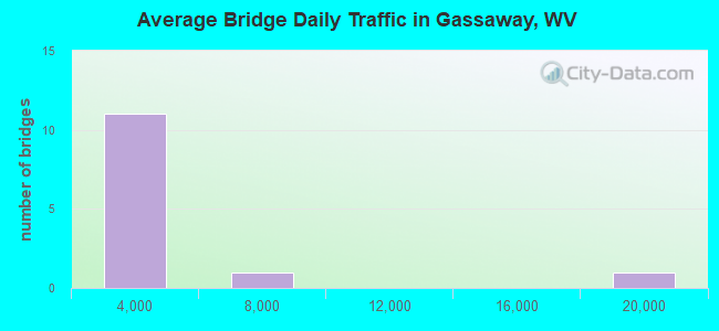
- 34,524Total average daily traffic
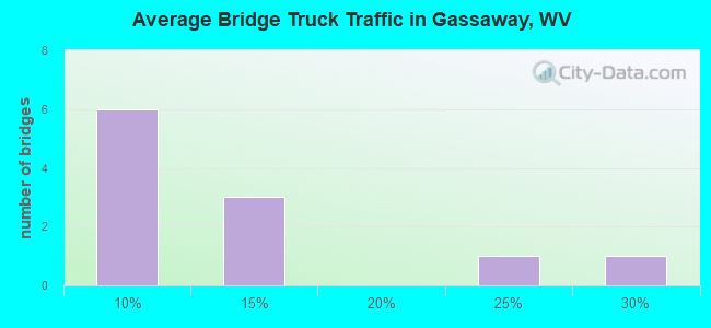
- 6,207Total average daily truck traffic
- National Bridge Inventory (NBI) Registered Bridges for Gassaway
- No street view available for this location
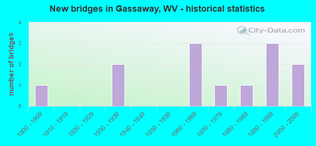
- New bridges - historical statistics
- 11900-1909
- 21930-1939
- 31960-1969
- 11970-1979
- 11980-1989
- 31990-1999
- 22000-2009
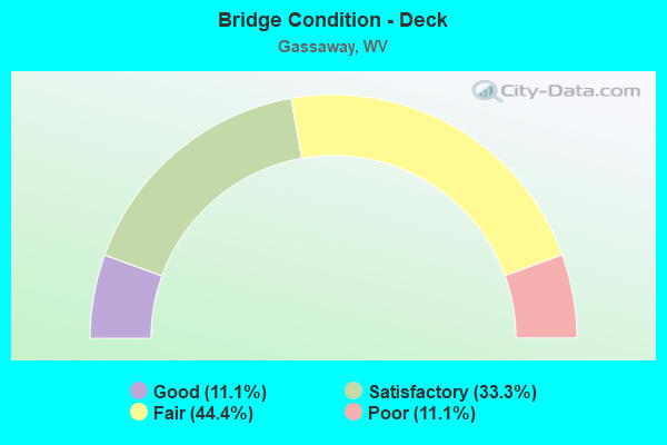
- Bridge Condition - Deck
- 11.1%Good
- 33.3%Satisfactory
- 44.4%Fair
- 11.1%Poor
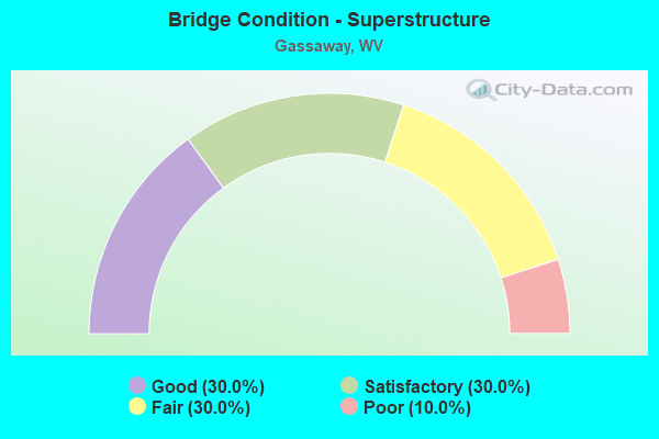
- Bridge Condition - Superstructure
- 30.0%Good
- 30.0%Satisfactory
- 30.0%Fair
- 10.0%Poor
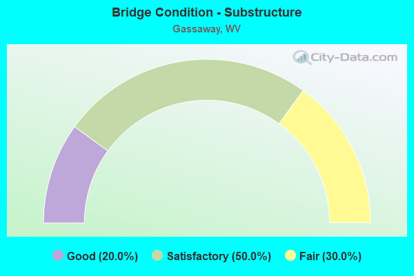
- Bridge Condition - Substructure
- 20.0%Good
- 50.0%Satisfactory
- 30.0%Fair
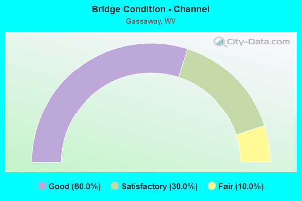
- Bridge Condition - Channel
- 60.0%Good
- 30.0%Satisfactory
- 10.0%Fair
Find on map >> Show street view
Structure Number: 4A012, Location: 0.06 MI N OF CO 13/3 SLS (Lat: 38.676150, Lng: -80.770950), Route carried "on" structure: State highway 400, Year Built: 1935, Status: Posted for load, Structure Length: 10.36m (33.99ft), Average Daily Traffic: 1,900 (year 2018), Truck Traffic: 9%, Average Future Daily Traffic: 1,995 (year 2038), Design Load: H 15, Features Intersected: ELK RIVER, Facility Carried by Structure: WV ROUTE 4 F
Minimum Vertical Clearance: 4.39m (14.40ft), Kilometerpoint: 28.743, Lanes on structure: 2, Owner: State Highway Agency, Approaching Roadway Width: 11.9m (39.0ft), Material/Design: Steel, Design/Construction: Truss - Thru, Number Of Spans In Main Unit: 1, Number Of Approach Spans: 3, Length of Maximum Span: 48.0m (157.5ft), Curb or Sidewalk Widths: Left: 1.5m (4.9ft), Right: 0.2m (0.7ft), Curb-To-Curb Width: 7.3m (24.0ft), Out-to-Out Width: 7.6m (24.9ft)
Condition: Deck: Poor, Superstructure: Poor, Substructure: Fair, Channel: Good, Operating Rating: 27.2 metric tons, Method Used To Determine Operating Rating: Load Factor (LF), Inventory Rating: 16.3 metric tons, Method Used To Determine Inventory Rating: Load Factor (LF), Structural Evaluation: Meets minimum limits, Deck Geometry: Meets minimum limits, Waterway Adequacy: Superior to present desirable criteria, Approach Roadway Alignment: Equal to present desirable criteria, Bridge Posting: Required (Relationship of Operating Rating to Maximum Legal Load: 30.0 - 39.9% below), Length Of Structure Improvement: 10.36m (33.99ft), Designated Inspection Frequency: Every 24 months, Critical Feature Inspection Frequency: Every 12 months, Inspection Date: September 2021, Critical Feature Inspection Date: September 2021, Bridge Improvement Cost: $1,065,000, Roadway Improvement Cost: $500,000, Total Project Cost: $1,881,000 ( Estimate for 2020), Deck Structure Type: Concrete Cast-file-Place, Wearing Surface/Protective System: Wearing Surface: Latex Concrete
Find on map >> Show street view
Structure Number: 4A015, Location: 0.01 MI S OF WV 4 (F) (Lat: 38.659939, Lng: -80.759100), Route carried "on" structure: County highway 1302, Year Built: 1964, Status: Open, Structure Length: 7.80m (25.59ft), Average Daily Traffic: 650 (year 2015), Truck Traffic: 10%, Average Future Daily Traffic: 950 (year 2035), Design Load: HS 20, Features Intersected: ELK RIVER, Facility Carried by Structure: COUNTY ROUTE 13/2
Minimum Vertical Clearance: 30+ m (98+ ft), Kilometerpoint: 5.166, Lanes on structure: 2, Owner: State Highway Agency, Approaching Roadway Width: 11.0m (36.1ft), Material/Design: Steel continuous, Design/Construction: Stringer/Multi-beam, Number Of Spans In Main Unit: 1, Number Of Approach Spans: 2, Length of Maximum Span: 30.1m (98.8ft), Curb or Sidewalk Widths: Left: 0.2m (0.7ft), Right: 1.5m (4.9ft), Curb-To-Curb Width: 8.5m (27.9ft), Out-to-Out Width: 11.2m (36.7ft)
Condition: Deck: Fair, Superstructure: Satisfactory, Substructure: Satisfactory, Channel: Good, Operating Rating: 68.0 metric tons, Method Used To Determine Operating Rating: Load Factor (LF), Inventory Rating: 40.8 metric tons, Method Used To Determine Inventory Rating: Load Factor (LF), Structural Evaluation: Equal to present minimum criteria, Deck Geometry: Somewhat better than minimum adequacy, Waterway Adequacy: Equal to present desirable criteria, Approach Roadway Alignment: Equal to present desirable criteria, Designated Inspection Frequency: Every 24 months, Underwater Inspection Frequency: Every 60 months, Inspection Date: March 2020, Underwater Inspection Date: July 2021, Deck Structure Type: Concrete Cast-file-Place
Find on map >> Show street view
Structure Number: 4A026, Location: 0.06 MI S CO 7/7 (Lat: 38.683050, Lng: -80.761069), Route carried "on" structure: County highway 700, Year Built: 1972, Status: Open, Structure Length: 0.96m (3.15ft), Average Daily Traffic: 947 (year 2015), Truck Traffic: 10%, Average Future Daily Traffic: 1,354 (year 2035), Design Load: HS 20, Features Intersected: LITTLE OTTER CREEK, Facility Carried by Structure: COUNTY ROUTE 7
Minimum Vertical Clearance: 30+ m (98+ ft), Kilometerpoint: 1.078, Lanes on structure: 2, Owner: State Highway Agency, Approaching Roadway Width: 8.5m (27.9ft), Material/Design: Prestressed concrete, Design/Construction: Channel Beam, Number Of Spans In Main Unit: 1, Length of Maximum Span: 8.7m (28.5ft), Curb or Sidewalk Widths: Left: 0.2m (0.7ft), Right: 0.2m (0.7ft), Curb-To-Curb Width: 7.8m (25.6ft), Out-to-Out Width: 8.3m (27.2ft)
Condition: Deck: Fair, Superstructure: Fair, Substructure: Fair, Channel: Fair, Operating Rating: 71.7 metric tons, Method Used To Determine Operating Rating: Field evaluation and documented engineering judgment, Inventory Rating: 32.7 metric tons, Method Used To Determine Inventory Rating: Field evaluation and documented engineering judgment, Structural Evaluation: Somewhat better than minimum adequacy, Deck Geometry: Meets minimum limits, Waterway Adequacy: Equal to present desirable criteria, Approach Roadway Alignment: Somewhat better than minimum adequacy, Designated Inspection Frequency: Every 24 months, Inspection Date: Febuary 2020, Deck Structure Type: Other, Wearing Surface/Protective System: Wearing Surface: Bituminous
Find on map >> Show street view
Structure Number: 4A027, Location: 0.03 MI N CO RT 20 SLS (Lat: 38.686431, Lng: -80.763869), Route carried "on" structure: County highway 700, Year Built: 1994, Status: Open, Structure Length: 1.51m (4.95ft), Average Daily Traffic: 1,000 (year 2018), Truck Traffic: 10%, Average Future Daily Traffic: 1,380 (year 2038), Design Load: HS 25 or greater, Features Intersected: BRUSHY FORK, Facility Carried by Structure: COUNTY ROUTE 7 SLS
Minimum Vertical Clearance: 30+ m (98+ ft), Kilometerpoint: 1.658, Lanes on structure: 2, Owner: State Highway Agency, Approaching Roadway Width: 7.3m (24.0ft), Skew: 3 degrees, Material/Design: Prestressed concrete, Design/Construction: Box Beam or Girders - Multiple, Number Of Spans In Main Unit: 1, Length of Maximum Span: 14.6m (47.9ft), Curb-To-Curb Width: 9.7m (31.8ft), Out-to-Out Width: 10.1m (33.1ft)
Condition: Deck: Satisfactory, Superstructure: Satisfactory, Substructure: Satisfactory, Channel: Satisfactory, Operating Rating: 88.9 metric tons, Method Used To Determine Operating Rating: Load and Resistance Factor (LRFR), Inventory Rating: 68.0 metric tons, Method Used To Determine Inventory Rating: Load and Resistance Factor (LRFR), Structural Evaluation: Equal to present minimum criteria, Deck Geometry: Equal to present minimum criteria, Waterway Adequacy: Equal to present minimum criteria, Approach Roadway Alignment: Equal to present desirable criteria, Designated Inspection Frequency: Every 48 months, Inspection Date: October 2020, Deck Structure Type: Other, Wearing Surface/Protective System: Deck Protection: Epoxy Coated Reinforcing
Find on map >> Show street view
Structure Number: 4A058, Location: 0.14 MI W OF US 19 (Lat: 38.617631, Lng: -80.756700), Route carried "on" structure: County highway 3200, Year Built: 1969, Status: Open, Structure Length: 6.71m (22.01ft), Average Daily Traffic: 6,000 (year 2018), Truck Traffic: 27%, Average Future Daily Traffic: 8,580 (year 2038), Design Load: HS 20, Features Intersected: COUNTY ROUTE 32, Facility Carried by Structure: COUNTY ROUTE 32
Minimum Vertical Clearance: 30+ m (98+ ft), Kilometerpoint: 10.235, Lanes on structure: 2, Lanes under structure: 5, Base Highway Network: Yes, Owner: State Highway Agency, Approaching Roadway Width: 13.7m (44.9ft), Material/Design: Steel continuous, Design/Construction: Stringer/Multi-beam, Number Of Spans In Main Unit: 2, Length of Maximum Span: 32.9m (107.9ft), Curb-To-Curb Width: 13.0m (42.7ft), Out-to-Out Width: 14.2m (46.6ft)
Condition: Deck: Fair, Superstructure: Fair, Substructure: Fair, Operating Rating: 71.7 metric tons, Method Used To Determine Operating Rating: Load Factor (LF), Inventory Rating: 42.6 metric tons, Method Used To Determine Inventory Rating: Load Factor (LF), Structural Evaluation: Somewhat better than minimum adequacy, Deck Geometry: Somewhat better than minimum adequacy, Underclear: Somewhat better than minimum adequacy, Approach Roadway Alignment: Equal to present desirable criteria, Length Of Structure Improvement: 6.71m (22.01ft), Designated Inspection Frequency: Every 24 months, Other Special Inspection Frequency: Every 12 months, Inspection Date: April 2020, Other Special Inspection Date: January 2021, Bridge Improvement Cost: $4,000,000, Roadway Improvement Cost: $500,000, Total Project Cost: $5,000,000 ( Estimate for 2021), Deck Structure Type: Concrete Cast-file-Place, Wearing Surface/Protective System: Wearing Surface: Latex Concrete
Find on map >> Show street view
Structure Number: 4A076, Location: 0.02 MI W OF CO 7 (Lat: 38.686019, Lng: -80.764461), Route carried "on" structure: County highway 2000, Year Built: 1988, Status: Open, Structure Length: 1.14m (3.74ft), Average Daily Traffic: 600 (year 2015), Truck Traffic: 6%, Average Future Daily Traffic: 875 (year 2035), Design Load: HS 25 or greater, Features Intersected: BRUSHY BRANCH, Facility Carried by Structure: COUNTY ROUTE 20
Minimum Vertical Clearance: 30+ m (98+ ft), Kilometerpoint: 11.201, Lanes on structure: 2, Owner: State Highway Agency, Approaching Roadway Width: 5.5m (18.0ft), Skew: 1 degrees, Material/Design: Prestressed concrete, Design/Construction: Box Beam or Girders - Multiple, Number Of Spans In Main Unit: 1, Length of Maximum Span: 11.0m (36.1ft), Curb-To-Curb Width: 6.2m (20.3ft), Out-to-Out Width: 6.4m (21.0ft)
Condition: Superstructure: Good, Substructure: Good, Channel: Satisfactory, Operating Rating: 68.0 metric tons, Method Used To Determine Operating Rating: Load and Resistance Factor (LRFR), Inventory Rating: 52.6 metric tons, Method Used To Determine Inventory Rating: Load and Resistance Factor (LRFR), Structural Evaluation: Better than present minimum criteria, Deck Geometry: High priority of corrective action, Waterway Adequacy: Somewhat better than minimum adequacy, Approach Roadway Alignment: Equal to present desirable criteria, Designated Inspection Frequency: Every 24 months, Inspection Date: June 2020, Deck Structure Type: Other, Wearing Surface/Protective System: Wearing Surface: Bituminous, Deck Protection: Epoxy Coated Reinforcing
Find on map >> Show street view
Structure Number: 4A148, Location: 0.01 MI S CO 13/4 (Lat: 38.657469, Lng: -80.802031), Route carried "on" structure: State highway 400, Year Built: 1930, Status: Open, Structure Length: 0.91m (2.99ft), Average Daily Traffic: 1,316 (year 2018), Truck Traffic: 8%, Average Future Daily Traffic: 1,816 (year 2038), Features Intersected: SUGAR CREEK, Facility Carried by Structure: WV 4
Minimum Vertical Clearance: 30+ m (98+ ft), Kilometerpoint: 23.561, Lanes on structure: 2, Owner: State Highway Agency, Approaching Roadway Width: 8.8m (28.9ft), Skew: 3 degrees, Material/Design: Concrete continuous, Design/Construction: Culvert, Number Of Spans In Main Unit: 2, Length of Maximum Span: 3.7m (12.1ft)
Condition: Channel: Satisfactory, Culverts: Fair, Operating Rating: 63.5 metric tons, Method Used To Determine Operating Rating: Field evaluation and documented engineering judgment, Inventory Rating: 29.0 metric tons, Method Used To Determine Inventory Rating: Field evaluation and documented engineering judgment, Structural Evaluation: Somewhat better than minimum adequacy, Waterway Adequacy: Equal to present minimum criteria, Approach Roadway Alignment: Equal to present desirable criteria, Designated Inspection Frequency: Every 24 months, Inspection Date: July 2020
Find on map >> Show street view
Structure Number: 4A151, Location: 0.06 MI S OF WV 4 (Lat: 38.676819, Lng: -80.770731), Route carried "on" structure: County highway 427, Year Built: 1991, Status: Posted for load, Structure Length: 3.63m (11.91ft), Average Daily Traffic: 100 (year 2018), Truck Traffic: 7%, Average Future Daily Traffic: 110 (year 2038), Design Load: HS 25 or greater, Features Intersected: LITTLE OTTER CREEK, Facility Carried by Structure: COUNTY ROUTE 4/27
Minimum Vertical Clearance: 30+ m (98+ ft), Kilometerpoint: 1.867, Lanes on structure: 2, Owner: State Highway Agency, Approaching Roadway Width: 5.5m (18.0ft), Material/Design: Steel, Design/Construction: Truss - Thru, Number Of Spans In Main Unit: 1, Length of Maximum Span: 35.1m (115.2ft), Curb-To-Curb Width: 6.0m (19.7ft), Out-to-Out Width: 6.1m (20.0ft)
Condition: Deck: Fair, Superstructure: Fair, Substructure: Satisfactory, Channel: Good, Operating Rating: 49.0 metric tons, Method Used To Determine Operating Rating: Load Factor (LF), Inventory Rating: 29.0 metric tons, Method Used To Determine Inventory Rating: Load Factor (LF), Structural Evaluation: Somewhat better than minimum adequacy, Deck Geometry: Meets minimum limits, Waterway Adequacy: Superior to present desirable criteria, Approach Roadway Alignment: Equal to present desirable criteria, Bridge Posting: Required (Relationship of Operating Rating to Maximum Legal Load: 0.1 - 9.9% below), Designated Inspection Frequency: Every 24 months, Critical Feature Inspection Frequency: Every 24 months, Inspection Date: August 2021, Critical Feature Inspection Date: April 2021, Deck Structure Type: Corrugated Steel, Wearing Surface/Protective System: Wearing Surface: Bituminous
Find on map >> Show street view
Structure Number: 4A163, Location: 0.01 MI N OF CO 7 SLS (Lat: 38.692011, Lng: -80.760800), Route carried "on" structure: County highway 708, Year Built: 1998, Status: Open, Structure Length: 1.27m (4.17ft), Average Daily Traffic: 40 (year 2015), Average Future Daily Traffic: 55 (year 2035), Design Load: HS 25 or greater, Features Intersected: BRUSHY BRANCH, Facility Carried by Structure: COUNTY ROUTE 7/8
Minimum Vertical Clearance: 30+ m (98+ ft), Kilometerpoint: 0.016, Lanes on structure: 2, Owner: State Highway Agency, Approaching Roadway Width: 4.3m (14.1ft), Material/Design: Prestressed concrete, Design/Construction: Box Beam or Girders - Multiple, Number Of Spans In Main Unit: 1, Length of Maximum Span: 11.6m (38.1ft), Curb-To-Curb Width: 9.2m (30.2ft), Out-to-Out Width: 9.3m (30.5ft)
Condition: Deck: Satisfactory, Superstructure: Satisfactory, Substructure: Satisfactory, Channel: Good, Operating Rating: 59.0 metric tons, Method Used To Determine Operating Rating: Load and Resistance Factor (LRFR), Inventory Rating: 45.4 metric tons, Method Used To Determine Inventory Rating: Load and Resistance Factor (LRFR), Structural Evaluation: Equal to present minimum criteria, Deck Geometry: Better than present minimum criteria, Waterway Adequacy: Better than present minimum criteria, Approach Roadway Alignment: Equal to present minimum criteria, Designated Inspection Frequency: Every 48 months, Inspection Date: July 2020, Deck Structure Type: Other, Wearing Surface/Protective System: Deck Protection: Epoxy Coated Reinforcing
Find on map >> Show street view
Structure Number: 4A18, Location: 0.15 MI N OF CO 4/24 SLS (Lat: 38.665161, Lng: -80.780161), Route carried "on" structure: State highway 400, Year Built: 2001, Status: Open, Structure Length: 13.81m (45.31ft), Average Daily Traffic: 1,871 (year 2015), Truck Traffic: 8%, Average Future Daily Traffic: 2,639 (year 2035), Design Load: HS 25 or greater, Features Intersected: ELK RIVER, Facility Carried by Structure: WV 4 F
Minimum Vertical Clearance: 30+ m (98+ ft), Kilometerpoint: 27.214, Lanes on structure: 2, Owner: State Highway Agency, Approaching Roadway Width: 10.4m (34.1ft), Material/Design: Steel continuous, Design/Construction: Stringer/Multi-beam, Number Of Spans In Main Unit: 1, Number Of Approach Spans: 2, Length of Maximum Span: 61.0m (200.1ft), Curb or Sidewalk Widths: Left: 0.0m, Right: 1.5m (4.9ft), Curb-To-Curb Width: 8.5m (27.9ft), Out-to-Out Width: 10.7m (35.1ft)
Condition: Deck: Satisfactory, Superstructure: Good, Substructure: Satisfactory, Channel: Good, Operating Rating: 29.0 metric tons, Method Used To Determine Operating Rating: Load and Resistance Factor (LRFR), Inventory Rating: 22.7 metric tons, Method Used To Determine Inventory Rating: Load and Resistance Factor (LRFR), Structural Evaluation: Equal to present minimum criteria, Deck Geometry: Somewhat better than minimum adequacy, Waterway Adequacy: Superior to present desirable criteria, Approach Roadway Alignment: Better than present minimum criteria, Designated Inspection Frequency: Every 24 months, Inspection Date: July 2020, Deck Structure Type: Concrete Cast-file-Place, Wearing Surface/Protective System: Wearing Surface: Monolithic Concrete, Deck Protection: Epoxy Coated Reinforcing
Find on map >> Show street view
Structure Number: 4A184, Location: 0.02 MI. N CO 7/8 (Lat: 38.692381, Lng: -80.760919), Route carried "on" structure: County highway 700, Year Built: 2006, Status: Open, Structure Length: 1.98m (6.50ft), Average Daily Traffic: 1,000 (year 2018), Truck Traffic: 6%, Average Future Daily Traffic: 1,380 (year 2038), Design Load: HS 20+Mod, Features Intersected: WALNUT FORK, Facility Carried by Structure: COUNTY ROUTE 7 SLS
Minimum Vertical Clearance: 30+ m (98+ ft), Kilometerpoint: 2.382, Lanes on structure: 2, Owner: State Highway Agency, Approaching Roadway Width: 7.3m (24.0ft), Skew: 5 degrees, Material/Design: Prestressed concrete, Design/Construction: Box Beam or Girders - Multiple, Number Of Spans In Main Unit: 1, Length of Maximum Span: 17.7m (58.1ft), Curb-To-Curb Width: 10.0m (32.8ft), Out-to-Out Width: 10.2m (33.5ft)
Condition: Deck: Good, Superstructure: Good, Substructure: Good, Channel: Good, Operating Rating: 69.8 metric tons, Method Used To Determine Operating Rating: Load and Resistance Factor (LRFR), Inventory Rating: 53.5 metric tons, Method Used To Determine Inventory Rating: Load and Resistance Factor (LRFR), Structural Evaluation: Better than present minimum criteria, Deck Geometry: Equal to present minimum criteria, Waterway Adequacy: Equal to present minimum criteria, Approach Roadway Alignment: Equal to present desirable criteria, Designated Inspection Frequency: Every 48 months, Inspection Date: November 2020, Deck Structure Type: Other, Wearing Surface/Protective System: Wearing Surface: Bituminous, Deck Protection: Epoxy Coated Reinforcing
Find on map >> Show street view
Structure Number: 4A058, Location: 0.14 MI W OF US 19 (Lat: 38.617650, Lng: -80.756700), Route carried "under" structure: Interstate 7900, Year Built: 1969, Structure Length: 0. m, Average Daily Traffic: 19,000 (year 0011), Truck Traffic: 20%, Features Intersected: COUNTY ROUTE 32, Facility Carried by Structure: COUNTY ROUTE 32
Minimum Vertical Clearance: 7.11m (23.33ft), Kilometerpoint: 92.264, Lanes on structure: 2, Lanes under structure: 5, Length of Maximum Span: 32.9m (107.9ft)
Find on map >> Show street view
Structure Number: 4A154, Location: 0.08 MI S OF WV 4 (Lat: 38.676850, Lng: -80.771819), Route carried "under" structure: County highway 427, Year Built: 1905, Structure Length: 0. m, Average Daily Traffic: 100 (year 2018), Features Intersected: C.R. 4/27, Facility Carried by Structure: RAILROAD
Minimum Vertical Clearance: 5.44m (17.85ft), Kilometerpoint: 1.802, Lanes under structure: 1, Material/Design: Steel, Design/Construction: Girder and Floorbeam System, Length of Maximum Span: 22.2m (72.8ft)