Bridge Statistics for Georgetown, Georgia (GA)
Condition, Traffic, Stress, Structural Evaluation, Project Costs
- National Bridge Inventory (NBI) Statistics
- 10Number of bridges
- 105ft / 32.5mTotal length
- $48,366,000Total costs
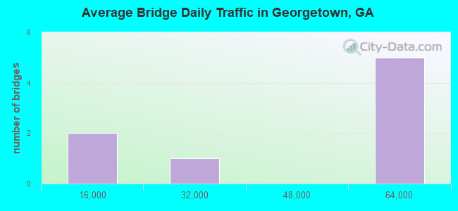
- 264,630Total average daily traffic
- 2,657Total average daily truck traffic
- National Bridge Inventory (NBI) Registered Bridges for Georgetown
- No street view available for this location

- New bridges - historical statistics
- 21960-1969
- 31970-1979
- 11980-1989
- 22010-2019
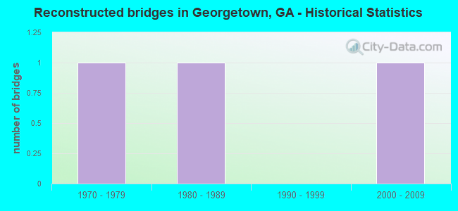
- Reconstructed bridges - Historical Statistics
- 11970-1979
- 11980-1989
- 01990-1999
- 12000-2009
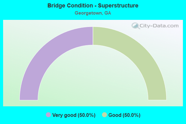
- Bridge Condition - Superstructure
- 50.0%Very good
- 50.0%Good
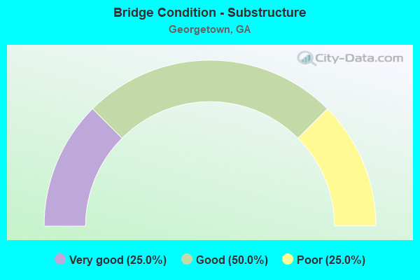
- Bridge Condition - Substructure
- 25.0%Very good
- 50.0%Good
- 25.0%Poor
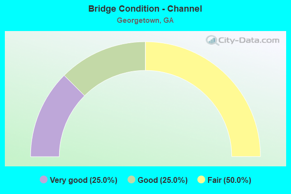
- Bridge Condition - Channel
- 25.0%Very good
- 25.0%Good
- 50.0%Fair
Find on map >> Show street view
Structure Number: 510043, Location: 8 MI SW OF SAVANNAH (Lat: 32.007431, Lng: -81.238450), Route carried "on" structure: US 17, Year Built: 1984, Year Reconstructed: 2000, Status: Open, Structure Length: 5.49m (18.01ft), Average Daily Traffic: 19,480 (year 2011), Truck Traffic: 1%, Average Future Daily Traffic: 29,220 (year 2031), Design Load: HS 20+Mod, Features Intersected: LITTLE OGEECHEE RIVER, Facility Carried by Structure: OCEAN HIGHWAY
Minimum Vertical Clearance: 30+ m (98+ ft), Kilometerpoint: 6.437, Lanes on structure: 4, Base Highway Network: Yes, Owner: State Highway Agency, Approaching Roadway Width: 20.1m (65.9ft), Skew: 29 degrees, Material/Design: Prestressed concrete, Design/Construction: Stringer/Multi-beam, Number Of Spans In Main Unit: 5, Length of Maximum Span: 11.0m (36.1ft), Curb-To-Curb Width: 27.5m (90.2ft), Out-to-Out Width: 28.4m (93.2ft)
Condition: Deck: Good, Superstructure: Good, Substructure: Good, Channel: Very good, Operating Rating: 55.3 metric tons, Method Used To Determine Operating Rating: Load Factor (LF), Inventory Rating: 32.6 metric tons, Method Used To Determine Inventory Rating: Load Factor (LF), Structural Evaluation: Better than present minimum criteria, Deck Geometry: Superior to present desirable criteria, Waterway Adequacy: Equal to present desirable criteria, Approach Roadway Alignment: Better than present minimum criteria, Designated Inspection Frequency: Every 24 months, Underwater Inspection Frequency: Every 60 months, Inspection Date: June 2020, Underwater Inspection Date: July 2019, Bridge Improvement Cost: $1,087,000, Roadway Improvement Cost: $109,000, Total Project Cost: $1,630,000, Deck Structure Type: Concrete Cast-file-Place
Find on map >> Show street view
Structure Number: 510073, Location: 8 MI SW OF SAVANNAH (Lat: 31.995089, Lng: -81.236508), Route carried "on" structure: State highway 204, Year Built: 1971, Status: Open, Structure Length: 2.74m (8.99ft), Average Daily Traffic: 48,980 (year 2011), Truck Traffic: 1%, Average Future Daily Traffic: 73,470 (year 2031), Design Load: HS 20+Mod, Features Intersected: TIDAL CANAL
Minimum Vertical Clearance: 30+ m (98+ ft), Kilometerpoint: 19.312, Lanes on structure: 4, Base Highway Network: Yes, Owner: State Highway Agency, Approaching Roadway Width: 24.7m (81.0ft), Skew: 30 degrees, Material/Design: Concrete, Design/Construction: Tee Beam, Number Of Spans In Main Unit: 3, Length of Maximum Span: 9.1m (29.9ft), Curb-To-Curb Width: 26.0m (85.3ft), Out-to-Out Width: 27.7m (90.9ft)
Condition: Deck: Good, Superstructure: Good, Substructure: Good, Channel: Good, Operating Rating: 45.3 metric tons, Method Used To Determine Operating Rating: Load Factor (LF), Inventory Rating: 27.2 metric tons, Method Used To Determine Inventory Rating: Load Factor (LF), Structural Evaluation: Equal to present minimum criteria, Deck Geometry: Superior to present desirable criteria, Waterway Adequacy: Equal to present desirable criteria, Approach Roadway Alignment: Equal to present desirable criteria, Designated Inspection Frequency: Every 24 months, Underwater Inspection Frequency: Every 60 months, Inspection Date: May 2020, Underwater Inspection Date: August 2019, Bridge Improvement Cost: $543,000, Roadway Improvement Cost: $54,000, Total Project Cost: $815,000, Deck Structure Type: Concrete Cast-file-Place
Find on map >> Show street view
Structure Number: 510074, Location: 8 MI SW OF SAVANNAH (Lat: 31.993378, Lng: -81.232247), Route carried "on" structure: State highway 204, Year Built: 1971, Status: Open, Structure Length: 6.37m (20.90ft), Average Daily Traffic: 48,980 (year 2011), Truck Traffic: 1%, Average Future Daily Traffic: 73,470 (year 2031), Design Load: HS 20+Mod, Features Intersected: CSX RAILROAD
Minimum Vertical Clearance: 30+ m (98+ ft), Kilometerpoint: 19.312, Lanes on structure: 4, Base Highway Network: Yes, Owner: State Highway Agency, Approaching Roadway Width: 26.2m (86.0ft), Skew: 30 degrees, Material/Design: Steel, Design/Construction: Stringer/Multi-beam, Number Of Spans In Main Unit: 3, Length of Maximum Span: 23.2m (76.1ft), Curb-To-Curb Width: 26.0m (85.3ft), Out-to-Out Width: 27.7m (90.9ft)
Condition: Deck: Good, Superstructure: Very good, Substructure: Good, Operating Rating: 37.1 metric tons, Method Used To Determine Operating Rating: Load Factor (LF), Inventory Rating: 21.7 metric tons, Method Used To Determine Inventory Rating: Load Factor (LF), Structural Evaluation: Somewhat better than minimum adequacy, Deck Geometry: Superior to present desirable criteria, Underclear: Superior to present desirable criteria, Approach Roadway Alignment: Equal to present desirable criteria, Designated Inspection Frequency: Every 24 months, Inspection Date: August 2020, Bridge Improvement Cost: $1,262,000, Roadway Improvement Cost: $126,000, Total Project Cost: $1,893,000, Deck Structure Type: Concrete Cast-file-Place
Find on map >> Show street view
Structure Number: 510075, Location: 4 MI E OF INT I-16 (Lat: 31.988558, Lng: -81.222939), Route carried "on" structure: State highway 204, Year Built: 1971, Status: Open, Structure Length: 5.43m (17.81ft), Average Daily Traffic: 48,980 (year 2011), Truck Traffic: 1%, Average Future Daily Traffic: 73,470 (year 2031), Design Load: HS 20+Mod, Features Intersected: CSX RAILROAD
Minimum Vertical Clearance: 30+ m (98+ ft), Kilometerpoint: 19.312, Lanes on structure: 5, Base Highway Network: Yes, Owner: State Highway Agency, Approaching Roadway Width: 25.6m (84.0ft), Skew: 30 degrees, Material/Design: Steel, Design/Construction: Stringer/Multi-beam, Number Of Spans In Main Unit: 3, Length of Maximum Span: 18.3m (60.0ft), Curb-To-Curb Width: 25.9m (85.0ft), Out-to-Out Width: 27.8m (91.2ft)
Condition: Deck: Good, Superstructure: Very good, Substructure: Good, Operating Rating: 48.0 metric tons, Method Used To Determine Operating Rating: Load Factor (LF), Inventory Rating: 29.0 metric tons, Method Used To Determine Inventory Rating: Load Factor (LF), Structural Evaluation: Better than present minimum criteria, Deck Geometry: Superior to present desirable criteria, Underclear: Equal to present desirable criteria, Approach Roadway Alignment: Equal to present desirable criteria, Designated Inspection Frequency: Every 24 months, Inspection Date: August 2020, Bridge Improvement Cost: $1,075,000, Roadway Improvement Cost: $107,000, Total Project Cost: $1,612,000, Deck Structure Type: Concrete Cast-file-Place
Find on map >> Show street view
Structure Number: 515104, Location: 4 MI E OF I-95/SR204 (Lat: 31.986047, Lng: -81.218131), Route carried "on" structure: State highway 204, Year Built: 2018, Status: Open, Structure Length: 4.85m (15.91ft), Average Daily Traffic: 48,980 (year 2011), Truck Traffic: 1%, Average Future Daily Traffic: 73,470 (year 2031), Design Load: HS 20+Mod, Features Intersected: KING GEORGE BLVD
Minimum Vertical Clearance: 30+ m (98+ ft), Kilometerpoint: 20.921, Lanes on structure: 3, Lanes under structure: 5, Base Highway Network: Yes, Owner: State Highway Agency, Approaching Roadway Width: 23.8m (78.1ft), Material/Design: Prestressed concrete, Design/Construction: Stringer/Multi-beam, Number Of Spans In Main Unit: 1, Length of Maximum Span: 48.5m (159.1ft), Curb-To-Curb Width: 23.7m (77.8ft), Out-to-Out Width: 24.7m (81.0ft)
Condition: Deck: Good, Superstructure: Very good, Substructure: Very good, Inventory Rating: 59.8 metric tons, Method Used To Determine Inventory Rating: Load Factor (LF), Structural Evaluation: Equal to present desirable criteria, Deck Geometry: Superior to present desirable criteria, Underclear: Superior to present desirable criteria, Approach Roadway Alignment: Equal to present desirable criteria, Length Of Structure Improvement: 5.82m (19.09ft), Designated Inspection Frequency: Every 24 months, Inspection Date: March 2020, Bridge Improvement Cost: $14,119,000, Roadway Improvement Cost: $1,411,000, Total Project Cost: $21,178,000 ( Estimate for 2018), Deck Structure Type: Concrete Cast-file-Place
Find on map >> Show street view
Structure Number: 515105, Location: 4 MI E OF I-95/SR204 (Lat: 31.986081, Lng: -81.217417), Route carried "on" structure: State highway 204, Year Built: 2018, Status: Open, Structure Length: 4.85m (15.91ft), Average Daily Traffic: 48,980 (year 2011), Truck Traffic: 1%, Average Future Daily Traffic: 73,470 (year 2031), Design Load: HS 20+Mod, Features Intersected: KING GEORGE BLVD
Minimum Vertical Clearance: 30+ m (98+ ft), Kilometerpoint: 20.921, Lanes on structure: 3, Lanes under structure: 5, Base Highway Network: Yes, Owner: State Highway Agency, Approaching Roadway Width: 23.8m (78.1ft), Material/Design: Prestressed concrete, Design/Construction: Stringer/Multi-beam, Number Of Spans In Main Unit: 1, Length of Maximum Span: 48.5m (159.1ft), Curb-To-Curb Width: 26.5m (86.9ft), Out-to-Out Width: 27.4m (89.9ft)
Condition: Deck: Good, Superstructure: Very good, Substructure: Very good, Inventory Rating: 51.7 metric tons, Method Used To Determine Inventory Rating: Load Factor (LF), Structural Evaluation: Equal to present desirable criteria, Deck Geometry: Superior to present desirable criteria, Underclear: Superior to present desirable criteria, Approach Roadway Alignment: Equal to present desirable criteria, Length Of Structure Improvement: 5.82m (19.09ft), Designated Inspection Frequency: Every 24 months, Inspection Date: March 2020, Bridge Improvement Cost: $14,119,000, Roadway Improvement Cost: $1,411,000, Total Project Cost: $21,178,000 ( Estimate for 2018), Deck Structure Type: Concrete Cast-file-Place
Find on map >> Show street view
Structure Number: CEPSAMGA0000002, Location: 1 MI N. OF GEORGTOWN GA (Lat: 31.891350, Lng: -85.106294), Route carried "on" structure: State lands road , Year Built: 1963, Year Reconstructed: 1989, Status: Posted for load, Structure Length: 1.36m (4.46ft), Average Daily Traffic: 125 (year 2021), Truck Traffic: 5%, Average Future Daily Traffic: 200 (year 2041), Design Load: H 20, Features Intersected: RIVER BLUFF PARK CREEK, Facility Carried by Structure: RIVER PARK ROAD A
Minimum Vertical Clearance: 30+ m (98+ ft), Kilometerpoint: 0.000, Lanes on structure: 2, Owner: Corps of Engineers (Civil), Maintenance Responsibility: County Highway Agency, Approaching Roadway Width: 6.7m (22.0ft), Material/Design: Prestressed concrete, Design/Construction: Slab, Number Of Spans In Main Unit: 3, Length of Maximum Span: 4.6m (15.1ft), Curb or Sidewalk Widths: Left: 0.4m (1.3ft), Right: 0.4m (1.3ft), Curb-To-Curb Width: 6.7m (22.0ft), Out-to-Out Width: 7.5m (24.6ft)
Condition: Deck: Good, Superstructure: Good, Substructure: Poor, Channel: Fair, Operating Rating: 29.3 metric tons, Method Used To Determine Operating Rating: Load Factor (LF), Inventory Rating: 12.2 metric tons, Method Used To Determine Inventory Rating: Load Factor (LF), Structural Evaluation: Meets minimum limits, Deck Geometry: Meets minimum limits, Waterway Adequacy: Somewhat better than minimum adequacy, Approach Roadway Alignment: Equal to present minimum criteria, Bridge Posting: Required (Relationship of Operating Rating to Maximum Legal Load: > 39.9% below), Length Of Structure Improvement: 7.62m (25.00ft), Designated Inspection Frequency: Every 24 months, Inspection Date: August 2021, Bridge Improvement Cost: $5,000, Roadway Improvement Cost: $5,000, Total Project Cost: $10,000 ( Estimate for 2021), Deck Structure Type: Concrete Precast Panels, Wearing Surface/Protective System: Wearing Surface: Other, Membrane: Built-up
Find on map >> Show street view
Structure Number: CEPSAMGA0000003, Location: 1 MI N. OF GEORGETOWN GA. (Lat: 31.889861, Lng: -85.106389), Route carried "on" structure: State lands road , Year Built: 1963, Year Reconstructed: 1984, Status: Posted for load, Structure Length: 1.36m (4.46ft), Average Daily Traffic: 125 (year 2021), Truck Traffic: 10%, Average Future Daily Traffic: 200 (year 2041), Design Load: H 20, Features Intersected: RIVER BLUFF PARK ACC. RD, Facility Carried by Structure: W.F.GEORGE ACC. RD
Minimum Vertical Clearance: 30+ m (98+ ft), Kilometerpoint: 0.000, Lanes on structure: 2, Owner: Corps of Engineers (Civil), Approaching Roadway Width: 6.7m (22.0ft), Material/Design: Prestressed concrete, Design/Construction: Slab, Number Of Spans In Main Unit: 3, Length of Maximum Span: 4.6m (15.1ft), Curb or Sidewalk Widths: Left: 0.4m (1.3ft), Right: 0.4m (1.3ft), Curb-To-Curb Width: 6.7m (22.0ft), Out-to-Out Width: 7.5m (24.6ft)
Condition: Deck: Good, Superstructure: Good, Substructure: Poor, Channel: Fair, Operating Rating: 43.2 metric tons, Method Used To Determine Operating Rating: Load Factor (LF), Inventory Rating: 32.4 metric tons, Method Used To Determine Inventory Rating: Load Factor (LF), Structural Evaluation: Meets minimum limits, Deck Geometry: Meets minimum limits, Waterway Adequacy: Equal to present desirable criteria, Approach Roadway Alignment: Meets minimum limits, Bridge Posting: Required (Relationship of Operating Rating to Maximum Legal Load: > 39.9% below), Length Of Structure Improvement: 4.57m (14.99ft), Designated Inspection Frequency: Every 24 months, Inspection Date: August 2021, Bridge Improvement Cost: $45,000, Roadway Improvement Cost: $3,000, Total Project Cost: $50,000 ( Estimate for 2021), Deck Structure Type: Concrete Precast Panels, Wearing Surface/Protective System: Wearing Surface: Other, Membrane: Built-up
Find on map >> Show street view
Structure Number: 515104, Location: 4 MI E OF I-95/SR204 (Lat: 31.986047, Lng: -81.218131), Route carried "under" structure: County highway 71, Structure Length: 0. m, Features Intersected: SR 204, Facility Carried by Structure: SR 204
Minimum Vertical Clearance: 5.48m (17.98ft), Kilometerpoint: 1.609, Lanes on structure: 3, Length of Maximum Span: 0.0m
Find on map >> Show street view
Structure Number: 515105, Location: 4 MI E OF I-95/SR204 (Lat: 31.986081, Lng: -81.217417), Route carried "under" structure: County highway 71, Structure Length: 0. m, Features Intersected: SR 204, Facility Carried by Structure: SR 204
Minimum Vertical Clearance: 5.48m (17.98ft), Kilometerpoint: 1.609, Lanes on structure: 3, Length of Maximum Span: 0.0m