Bridge Statistics for Gibsonia, Pennsylvania (PA)
Condition, Traffic, Stress, Structural Evaluation, Project Costs
- National Bridge Inventory (NBI) Statistics
- 11Number of bridges
- 79ft / 23.9mTotal length
- $59,000Total costs
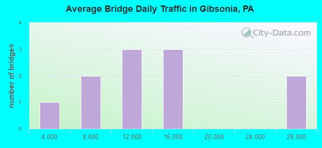
- 136,346Total average daily traffic
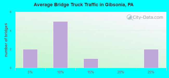
- 18,106Total average daily truck traffic
- National Bridge Inventory (NBI) Registered Bridges for Gibsonia
- No street view available for this location
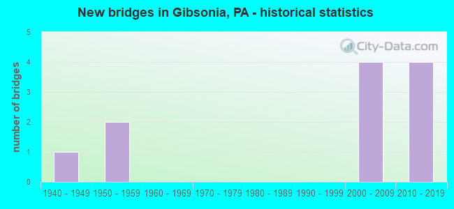
- New bridges - historical statistics
- 11940-1949
- 21950-1959
- 42000-2009
- 42010-2019
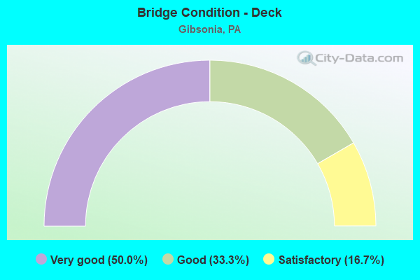
- Bridge Condition - Deck
- 50.0%Very good
- 33.3%Good
- 16.7%Satisfactory
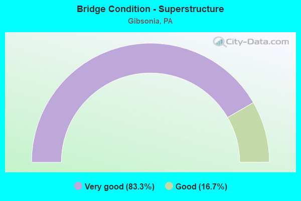
- Bridge Condition - Superstructure
- 83.3%Very good
- 16.7%Good
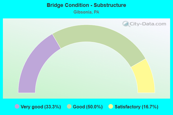
- Bridge Condition - Substructure
- 33.3%Very good
- 50.0%Good
- 16.7%Satisfactory
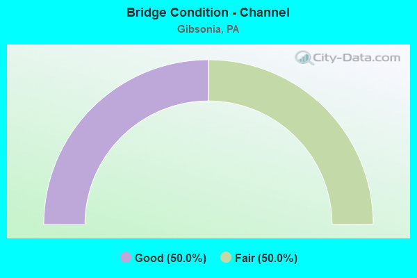
- Bridge Condition - Channel
- 50.0%Good
- 50.0%Fair
Find on map >> Show street view
Structure Number: 1331, Location: @ INTER. W/ TWP. RD. 828 (Lat: 40.631244, Lng: -79.987781), Route carried "on" structure: State highway 910, Year Built: 1940, Status: Open, Structure Length: 1.16m (3.81ft), Average Daily Traffic: 8,256 (year 2020), Truck Traffic: 8%, Average Future Daily Traffic: 15,244 (year 2032), Design Load: HS 20, Features Intersected: MONTOUR RUN, Facility Carried by Structure: GIBSONIA RD
Minimum Vertical Clearance: 30+ m (98+ ft), Kilometerpoint: 9.835, Lanes on structure: 2, Owner: State Highway Agency, Approaching Roadway Width: 11.6m (38.1ft), Skew: 2 degrees, Material/Design: Concrete, Design/Construction: Tee Beam, Number Of Spans In Main Unit: 1, Length of Maximum Span: 10.1m (33.1ft), Curb-To-Curb Width: 12.8m (42.0ft), Out-to-Out Width: 13.7m (44.9ft)
Condition: Deck: Satisfactory, Superstructure: Good, Substructure: Satisfactory, Channel: Fair, Operating Rating: 61.7 metric tons, Method Used To Determine Operating Rating: Load Factor (LF), Inventory Rating: 37.2 metric tons, Method Used To Determine Inventory Rating: Load Factor (LF), Structural Evaluation: Equal to present minimum criteria, Deck Geometry: Somewhat better than minimum adequacy, Waterway Adequacy: Superior to present desirable criteria, Approach Roadway Alignment: Equal to present minimum criteria, Length Of Structure Improvement: 1.20m (3.94ft), Designated Inspection Frequency: Every 24 months, Inspection Date: October 2019, Bridge Improvement Cost: $4,000, Roadway Improvement Cost: $26,000, Total Project Cost: $59,000, Deck Structure Type: Concrete Cast-file-Place, Wearing Surface/Protective System: Wearing Surface: Bituminous
Find on map >> Show street view
Structure Number: 44239, Location: 0.5 MI N SR 910 (Lat: 40.640372, Lng: -80.009006), Route carried "on" structure: State highway , Year Built: 2007, Status: Open, Structure Length: 6.31m (20.70ft), Average Daily Traffic: 5,845 (year 2022), Truck Traffic: 6%, Average Future Daily Traffic: 6,304 (year 2032), Design Load: HL 93, Features Intersected: PA TURNPIKE, Facility Carried by Structure: BABCOCK BLVD
Minimum Vertical Clearance: 30+ m (98+ ft), Kilometerpoint: 8.116, Lanes on structure: 2, Lanes under structure: 4, Owner: State Highway Agency, Approaching Roadway Width: 13.1m (43.0ft), Skew: 2 degrees, Material/Design: Prestressed concrete, Design/Construction: Stringer/Multi-beam, Number Of Spans In Main Unit: 2, Length of Maximum Span: 34.4m (112.9ft), Curb or Sidewalk Widths: Left: 0.2m (0.7ft), Right: 0.2m (0.7ft), Curb-To-Curb Width: 13.1m (43.0ft), Out-to-Out Width: 13.2m (43.3ft)
Condition: Deck: Good, Superstructure: Very good, Substructure: Good, Operating Rating: 60.6 metric tons, Method Used To Determine Operating Rating: Assigned ratings based on Load and Resistance Factor Design (LRFD) reported by rating factor (RF) using HL93 loadings, Inventory Rating: 34.3 metric tons, Method Used To Determine Inventory Rating: Assigned ratings based on Load and Resistance Factor Design (LRFD) reported by rating factor (RF) using HL93 loadings, Structural Evaluation: Better than present minimum criteria, Deck Geometry: Somewhat better than minimum adequacy, Underclear: Superior to present desirable criteria, Approach Roadway Alignment: Equal to present desirable criteria, Designated Inspection Frequency: Every 48 months, Inspection Date: June 2018, Deck Structure Type: Concrete Cast-file-Place, Wearing Surface/Protective System: Wearing Surface: Monolithic Concrete, Deck Protection: Epoxy Coated Reinforcing
Find on map >> Show street view
Structure Number: 45201, Location: OVER PA TURNPIKE (Lat: 40.630122, Lng: -79.985367), Route carried "on" structure: State highway 910, Year Built: 2008, Status: Open, Structure Length: 5.97m (19.59ft), Average Daily Traffic: 8,256 (year 2020), Truck Traffic: 8%, Average Future Daily Traffic: 15,244 (year 2032), Design Load: HS 20, Features Intersected: PA TURNPIKE, Facility Carried by Structure: GIBSONIA ROAD
Minimum Vertical Clearance: 30+ m (98+ ft), Kilometerpoint: 9.835, Lanes on structure: 2, Lanes under structure: 5, Owner: State Highway Agency, Approaching Roadway Width: 7.3m (24.0ft), Skew: 4 degrees, Material/Design: Steel continuous, Design/Construction: Stringer/Multi-beam, Number Of Spans In Main Unit: 2, Length of Maximum Span: 59.1m (193.9ft), Curb or Sidewalk Widths: Left: 0.2m (0.7ft), Right: 0.2m (0.7ft), Curb-To-Curb Width: 13.4m (44.0ft), Out-to-Out Width: 14.4m (47.2ft)
Condition: Deck: Very good, Superstructure: Very good, Substructure: Very good, Operating Rating: 74.4 metric tons, Method Used To Determine Operating Rating: Load Factor (LF), Inventory Rating: 44.5 metric tons, Method Used To Determine Inventory Rating: Load Factor (LF), Structural Evaluation: Equal to present desirable criteria, Deck Geometry: Equal to present minimum criteria, Underclear: Somewhat better than minimum adequacy, Approach Roadway Alignment: Better than present minimum criteria, Designated Inspection Frequency: Every 24 months, Inspection Date: October 2019, Deck Structure Type: Concrete Cast-file-Place, Wearing Surface/Protective System: Wearing Surface: Monolithic Concrete, Deck Protection: Epoxy Coated Reinforcing
Find on map >> Show street view
Structure Number: 47184, Location: West of Gibsonia (Lat: 40.640000, Lng: -80.021667), Route carried "on" structure: Interstate 76, Year Built: 2012, Status: Open, Structure Length: 5.15m (16.90ft), Average Daily Traffic: 15,732 (year 2010), Truck Traffic: 11%, Average Future Daily Traffic: 18,470 (year 2030), Design Load: HL 93, Features Intersected: SR 4063, LR 02141
Minimum Vertical Clearance: 30+ m (98+ ft), Kilometerpoint: 0.000, Lanes on structure: 6, Lanes under structure: 2, Base Highway Network: Yes, Toll: Toll bridge, Owner: State Toll Authority, Approaching Roadway Width: 37.2m (122.0ft), Skew: 32 degrees, Material/Design: Prestressed concrete, Design/Construction: Stringer/Multi-beam, Number Of Spans In Main Unit: 1, Length of Maximum Span: 49.4m (162.1ft), Curb or Sidewalk Widths: Left: 0.2m (0.7ft), Right: 0.2m (0.7ft), Curb-To-Curb Width: 36.0m (118.1ft), Out-to-Out Width: 38.2m (125.3ft)
Condition: Deck: Very good, Superstructure: Very good, Substructure: Good, Operating Rating: 79.7 metric tons, Method Used To Determine Operating Rating: Assigned ratings based on Load and Resistance Factor Design (LRFD) reported by rating factor (RF) using HL93 loadings, Inventory Rating: 38.9 metric tons, Method Used To Determine Inventory Rating: Assigned ratings based on Load and Resistance Factor Design (LRFD) reported by rating factor (RF) using HL93 loadings, Structural Evaluation: Better than present minimum criteria, Deck Geometry: Superior to present desirable criteria, Underclear: Superior to present desirable criteria, Approach Roadway Alignment: Equal to present desirable criteria, Designated Inspection Frequency: Every 24 months, Inspection Date: May 2020, Deck Structure Type: Concrete Cast-file-Place, Wearing Surface/Protective System: Wearing Surface: Monolithic Concrete, Membrane: Other, Deck Protection: Epoxy Coated Reinforcing
Find on map >> Show street view
Structure Number: 47186, Location: West of Gibsonia (Lat: 40.635000, Lng: -79.991667), Route carried "on" structure: Interstate 76, Year Built: 2012, Status: Open, Structure Length: 3.54m (11.61ft), Average Daily Traffic: 27,341 (year 2001), Truck Traffic: 24%, Average Future Daily Traffic: 40,196 (year 2030), Design Load: HL 93, Features Intersected: T-574
Minimum Vertical Clearance: 30+ m (98+ ft), Kilometerpoint: 0.000, Lanes on structure: 6, Lanes under structure: 2, Base Highway Network: Yes, Toll: On toll road, Owner: State Toll Authority, Approaching Roadway Width: 37.2m (122.0ft), Skew: 30 degrees, Material/Design: Prestressed concrete, Design/Construction: Stringer/Multi-beam, Number Of Spans In Main Unit: 1, Length of Maximum Span: 34.7m (113.8ft), Curb or Sidewalk Widths: Left: 0.2m (0.7ft), Right: 0.2m (0.7ft), Curb-To-Curb Width: 36.0m (118.1ft), Out-to-Out Width: 38.2m (125.3ft)
Condition: Deck: Good, Superstructure: Very good, Substructure: Good, Operating Rating: 62.9 metric tons, Method Used To Determine Operating Rating: Assigned ratings based on Load and Resistance Factor Design (LRFD) reported by rating factor (RF) using HL93 loadings, Inventory Rating: 37.9 metric tons, Method Used To Determine Inventory Rating: Assigned ratings based on Load and Resistance Factor Design (LRFD) reported by rating factor (RF) using HL93 loadings, Structural Evaluation: Better than present minimum criteria, Deck Geometry: Superior to present desirable criteria, Underclear: High priority of corrective action, Approach Roadway Alignment: Equal to present desirable criteria, Designated Inspection Frequency: Every 24 months, Inspection Date: May 2020, Deck Structure Type: Concrete Cast-file-Place, Wearing Surface/Protective System: Wearing Surface: Monolithic Concrete, Membrane: Other, Deck Protection: Epoxy Coated Reinforcing
Find on map >> Show street view
Structure Number: 48348, Location: 600' FROM INTER.W/02141 (Lat: 40.627872, Lng: -80.025392), Route carried "on" structure: State highway 910, Year Built: 2013, Status: Open, Structure Length: 1.77m (5.81ft), Average Daily Traffic: 11,722 (year 2022), Truck Traffic: 1%, Average Future Daily Traffic: 10,000 (year 2034), Design Load: HL 93, Features Intersected: NORTH FORK PINE CREEK, Facility Carried by Structure: SALEM HOLLOW RD
Minimum Vertical Clearance: 30+ m (98+ ft), Kilometerpoint: 6.141, Lanes on structure: 2, Owner: State Highway Agency, Approaching Roadway Width: 12.2m (40.0ft), Skew: 1 degrees, Material/Design: Prestressed concrete, Design/Construction: Box Beam or Girders - Single/Spread, Number Of Spans In Main Unit: 1, Length of Maximum Span: 16.5m (54.1ft), Curb or Sidewalk Widths: Left: 0.2m (0.7ft), Right: 0.2m (0.7ft), Curb-To-Curb Width: 12.2m (40.0ft), Out-to-Out Width: 13.2m (43.3ft)
Condition: Deck: Very good, Superstructure: Very good, Substructure: Very good, Channel: Good, Operating Rating: 61.6 metric tons, Method Used To Determine Operating Rating: Assigned ratings based on Load and Resistance Factor Design (LRFD) reported by rating factor (RF) using HL93 loadings, Inventory Rating: 38.9 metric tons, Method Used To Determine Inventory Rating: Assigned ratings based on Load and Resistance Factor Design (LRFD) reported by rating factor (RF) using HL93 loadings, Structural Evaluation: Equal to present desirable criteria, Deck Geometry: Somewhat better than minimum adequacy, Waterway Adequacy: Superior to present desirable criteria, Approach Roadway Alignment: Equal to present desirable criteria, Designated Inspection Frequency: Every 24 months, Inspection Date: October 2019, Deck Structure Type: Concrete Cast-file-Place, Wearing Surface/Protective System: Wearing Surface: Monolithic Concrete, Deck Protection: Epoxy Coated Reinforcing
Find on map >> Show street view
Structure Number: 2062, Location: SOUTH OF GIBSONIA (Lat: 40.615039, Lng: -79.975939), Route carried "under" structure: Interstate 76, Year Built: 2006, Structure Length: 0. m, Average Daily Traffic: 27,341 (year 2001), Truck Traffic: 24%, Features Intersected: PA TURNPIKE, Facility Carried by Structure: HARDT ROAD
Minimum Vertical Clearance: 10.87m (35.66ft), Kilometerpoint: 0.000, Lanes on structure: 2, Lanes under structure: 4, Material/Design: Prestressed concrete continuous, Design/Construction: Stringer/Multi-beam, Length of Maximum Span: 26.2m (86.0ft)
Find on map >> Show street view
Structure Number: 2065, Location: HAMPTON-TPK RP.AB O/TRE 8 (Lat: 40.616667, Lng: -79.950000), Route carried "under" structure: State highway 8, Year Built: 1950, Structure Length: 0. m, Average Daily Traffic: 13,714 (year 2022), Truck Traffic: 5%, Features Intersected: SR 0008, LR72, Facility Carried by Structure: PA TPK (I-76)
Minimum Vertical Clearance: 4.27m (14.01ft), Kilometerpoint: 25.899, Lanes on structure: 2, Lanes under structure: 5, Material/Design: Steel, Design/Construction: Girder and Floorbeam System, Length of Maximum Span: 26.2m (86.0ft)
Find on map >> Show street view
Structure Number: 2065, Location: HAMPTON-TPK RP.AB O/TRE 8 (Lat: 40.616667, Lng: -79.950000), Route carried "under" structure: State highway 8, Year Built: 1950, Structure Length: 0. m, Average Daily Traffic: 14,002 (year 2022), Truck Traffic: 5%, Features Intersected: SR 0008, LR72, Facility Carried by Structure: PA TPK (I-76)
Minimum Vertical Clearance: 4.32m (14.17ft), Kilometerpoint: 25.902, Lanes on structure: 2, Lanes under structure: 5, Material/Design: Steel, Design/Construction: Girder and Floorbeam System, Length of Maximum Span: 26.2m (86.0ft)
Find on map >> Show street view
Structure Number: 45201, Location: OVER PA TURNPIKE (Lat: 40.630122, Lng: -79.985367), Route carried "under" structure: Interstate 76, Year Built: 2008, Structure Length: 0. m, Average Daily Traffic: 2 (year 0000), Features Intersected: PA TURNPIKE, Facility Carried by Structure: GIBSONIA ROAD
Minimum Vertical Clearance: 4.91m (16.11ft), Kilometerpoint: 0.000, Lanes on structure: 2, Lanes under structure: 5, Toll: On Interstate toll segment, Material/Design: Steel continuous, Design/Construction: Stringer/Multi-beam, Length of Maximum Span: 59.1m (193.9ft)
Find on map >> Show street view
Structure Number: 47184, Location: West of Gibsonia (Lat: 40.640000, Lng: -80.021667), Route carried "under" structure: State highway , Year Built: 2012, Structure Length: 0. m, Average Daily Traffic: 4,135 (year 2020), Truck Traffic: 2%, Features Intersected: SR 4063, LR 02141, Facility Carried by Structure: PA TPK (I-76)
Minimum Vertical Clearance: 9.38m (30.77ft), Kilometerpoint: 2.132, Lanes on structure: 6, Lanes under structure: 2, Material/Design: Prestressed concrete, Design/Construction: Stringer/Multi-beam, Length of Maximum Span: 49.4m (162.1ft)