Bridge Statistics for Girard, Ohio (OH)
Condition, Traffic, Stress, Structural Evaluation, Project Costs
- National Bridge Inventory (NBI) Statistics
- 39Number of bridges
- 669ft / 204mTotal length
- $1,560,000Total costs
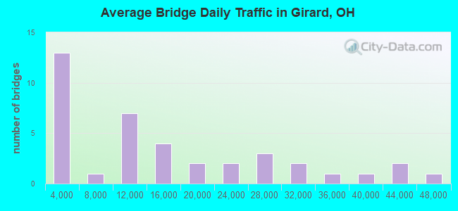
- 565,366Total average daily traffic
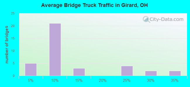
- 84,083Total average daily truck traffic
- National Bridge Inventory (NBI) Registered Bridges for Girard
- No street view available for this location
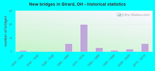
- New bridges - historical statistics
- 11930-1939
- 61960-1969
- 201970-1979
- 31980-1989
- 11990-1999
- 22000-2009
- 62010-2019
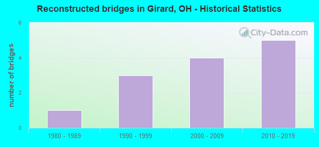
- Reconstructed bridges - Historical Statistics
- 11980-1989
- 31990-1999
- 42000-2009
- 52010-2019
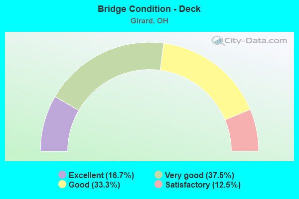
- Bridge Condition - Deck
- 16.7%Excellent
- 37.5%Very good
- 33.3%Good
- 12.5%Satisfactory
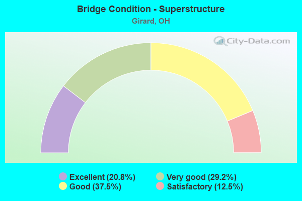
- Bridge Condition - Superstructure
- 20.8%Excellent
- 29.2%Very good
- 37.5%Good
- 12.5%Satisfactory
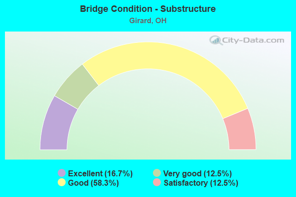
- Bridge Condition - Substructure
- 16.7%Excellent
- 12.5%Very good
- 58.3%Good
- 12.5%Satisfactory
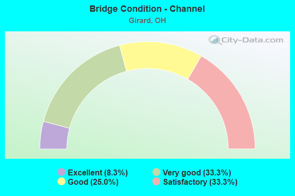
- Bridge Condition - Channel
- 8.3%Excellent
- 33.3%Very good
- 25.0%Good
- 33.3%Satisfactory
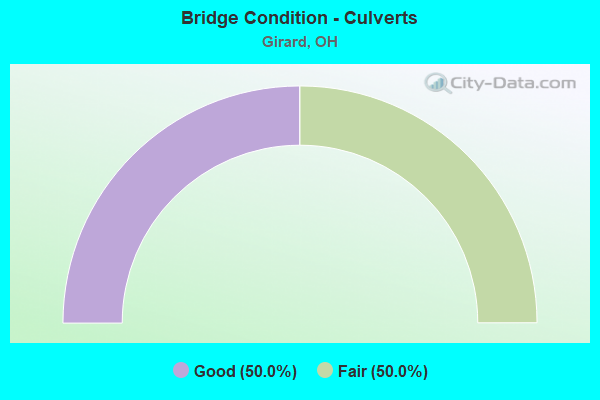
- Bridge Condition - Culverts
- 50.0%Good
- 50.0%Fair
Find on map >> Show street view
Structure Number: 7801718, Location: 3.36 MI S OF SR 82 (Lat: 41.184689, Lng: -80.690181), Route carried "on" structure: County highway C0028, Year Built: 1970, Status: Open, Structure Length: 10.07m (33.04ft), Average Daily Traffic: 11,620 (year 2015), Truck Traffic: 7%, Average Future Daily Traffic: 49,695 (year 2035), Design Load: HS 20, Features Intersected: SR 11, Facility Carried by Structure: TIBBETS WICK ROAD
Minimum Vertical Clearance: 30+ m (98+ ft), Kilometerpoint: 2.140, Lanes on structure: 4, Lanes under structure: 4, Owner: State Highway Agency, Approaching Roadway Width: 18.9m (62.0ft), Skew: 3 degrees, Material/Design: Steel continuous, Design/Construction: Stringer/Multi-beam, Number Of Spans In Main Unit: 4, Length of Maximum Span: 30.0m (98.4ft), Curb-To-Curb Width: 18.9m (62.0ft), Out-to-Out Width: 19.8m (65.0ft)
Condition: Deck: Good, Superstructure: Good, Substructure: Good, Operating Rating: 42.1 metric tons, Method Used To Determine Operating Rating: Load Factor (LF) rating reported by rating factor (RF) method using MS18 loading, Inventory Rating: 32.4 metric tons, Method Used To Determine Inventory Rating: Load Factor (LF) rating reported by rating factor (RF) method using MS18 loading, Structural Evaluation: Better than present minimum criteria, Deck Geometry: Equal to present minimum criteria, Underclear: High priority of corrective action, Approach Roadway Alignment: Superior to present desirable criteria, Designated Inspection Frequency: Every 24 months, Inspection Date: June 2021, Deck Structure Type: Concrete Cast-file-Place, Wearing Surface/Protective System: Wearing Surface: Monolithic Concrete, Deck Protection: Internally Sealed
Find on map >> Show street view
Structure Number: 7801777, Location: 2.54 MI S OF SR 82 (Lat: 41.194169, Lng: -80.699519), Route carried "on" structure: County highway C0046, Year Built: 1970, Year Reconstructed: 2017, Status: Open, Structure Length: 10.35m (33.96ft), Average Daily Traffic: 1,295 (year 2018), Truck Traffic: 5%, Average Future Daily Traffic: 1,000 (year 2038), Design Load: HS 20+Mod, Features Intersected: SR 11, Facility Carried by Structure: ANDERSON MORRIS RD
Minimum Vertical Clearance: 30+ m (98+ ft), Kilometerpoint: 0.917, Lanes on structure: 2, Lanes under structure: 4, Owner: State Highway Agency, Approaching Roadway Width: 11.0m (36.1ft), Skew: 3 degrees, Material/Design: Steel continuous, Design/Construction: Stringer/Multi-beam, Number Of Spans In Main Unit: 4, Length of Maximum Span: 30.8m (101.0ft), Curb-To-Curb Width: 8.5m (27.9ft), Out-to-Out Width: 9.4m (30.8ft)
Condition: Deck: Satisfactory, Superstructure: Satisfactory, Substructure: Good, Operating Rating: 42.1 metric tons, Method Used To Determine Operating Rating: Load Factor (LF) rating reported by rating factor (RF) method using MS18 loading, Inventory Rating: 32.4 metric tons, Method Used To Determine Inventory Rating: Load Factor (LF) rating reported by rating factor (RF) method using MS18 loading, Structural Evaluation: Equal to present minimum criteria, Deck Geometry: Somewhat better than minimum adequacy, Underclear: High priority of corrective action, Approach Roadway Alignment: Superior to present desirable criteria, Designated Inspection Frequency: Every 12 months, Inspection Date: May 2021, Deck Structure Type: Concrete Cast-file-Place, Wearing Surface/Protective System: Wearing Surface: Monolithic Concrete, Deck Protection: Epoxy Coated Reinforcing
Find on map >> Show street view
Structure Number: 7801807, Location: 1.61 MI S OF SR 82 (Lat: 41.205581, Lng: -80.709111), Route carried "on" structure: County highway C0056, Year Built: 1970, Year Reconstructed: 2008, Status: Open, Structure Length: 8.75m (28.71ft), Average Daily Traffic: 3,462 (year 2015), Truck Traffic: 5%, Average Future Daily Traffic: 58,064 (year 2035), Design Load: H 15, Features Intersected: SR 11, Facility Carried by Structure: NILES-VIENNA ROAD
Minimum Vertical Clearance: 30+ m (98+ ft), Kilometerpoint: 3.685, Lanes on structure: 2, Lanes under structure: 4, Owner: State Highway Agency, Approaching Roadway Width: 13.4m (44.0ft), Skew: 1 degrees, Material/Design: Steel continuous, Design/Construction: Stringer/Multi-beam, Number Of Spans In Main Unit: 4, Length of Maximum Span: 25.3m (83.0ft), Curb-To-Curb Width: 9.8m (32.2ft), Out-to-Out Width: 10.7m (35.1ft)
Condition: Deck: Very good, Superstructure: Good, Substructure: Good, Operating Rating: 42.1 metric tons, Method Used To Determine Operating Rating: Load Factor (LF) rating reported by rating factor (RF) method using MS18 loading, Inventory Rating: 32.4 metric tons, Method Used To Determine Inventory Rating: Load Factor (LF) rating reported by rating factor (RF) method using MS18 loading, Structural Evaluation: Better than present minimum criteria, Deck Geometry: Meets minimum limits, Underclear: High priority of corrective action, Approach Roadway Alignment: Equal to present desirable criteria, Designated Inspection Frequency: Every 24 months, Inspection Date: June 2021, Deck Structure Type: Concrete Cast-file-Place, Wearing Surface/Protective System: Wearing Surface: Monolithic Concrete, Deck Protection: Epoxy Coated Reinforcing
Find on map >> Show street view
Structure Number: 7801831, Location: 0.27 MI S OF SR 82 (Lat: 41.224381, Lng: -80.709931), Route carried "on" structure: State highway 11, Year Built: 1970, Year Reconstructed: 2010, Status: Open, Structure Length: 9.10m (29.86ft), Average Daily Traffic: 14,251 (year 2015), Truck Traffic: 9%, Average Future Daily Traffic: 19,780 (year 2035), Design Load: HS 20+Mod, Features Intersected: OVER RAMP (NB11 TO 82WB)
Minimum Vertical Clearance: 30+ m (98+ ft), Kilometerpoint: 14.919, Lanes on structure: 2, Lanes under structure: 2, Base Highway Network: Yes, Owner: State Highway Agency, Approaching Roadway Width: 10.1m (33.1ft), Skew: 6 degrees, Material/Design: Steel continuous, Design/Construction: Stringer/Multi-beam, Number Of Spans In Main Unit: 3, Length of Maximum Span: 35.8m (117.5ft), Curb-To-Curb Width: 10.1m (33.1ft), Out-to-Out Width: 11.0m (36.1ft)
Condition: Deck: Good, Superstructure: Good, Substructure: Good, Operating Rating: 81.0 metric tons, Method Used To Determine Operating Rating: Load Factor (LF) rating reported by rating factor (RF) method using MS18 loading, Inventory Rating: 77.8 metric tons, Method Used To Determine Inventory Rating: Load Factor (LF) rating reported by rating factor (RF) method using MS18 loading, Structural Evaluation: Better than present minimum criteria, Deck Geometry: Meets minimum limits, Underclear: Somewhat better than minimum adequacy, Approach Roadway Alignment: Superior to present desirable criteria, Designated Inspection Frequency: Every 24 months, Inspection Date: September 2021, Deck Structure Type: Concrete Cast-file-Place, Wearing Surface/Protective System: Wearing Surface: Monolithic Concrete, Deck Protection: Epoxy Coated Reinforcing
Find on map >> Show street view
Structure Number: 780189, Location: JCT OF SR 11 AND SR 82 (Lat: 41.228789, Lng: -80.708481), Route carried "on" structure: State highway 11, Year Built: 1970, Year Reconstructed: 2011, Status: Open, Structure Length: 8.46m (27.76ft), Average Daily Traffic: 14,251 (year 2015), Truck Traffic: 9%, Average Future Daily Traffic: 19,780 (year 2035), Design Load: HS 20+Mod, Features Intersected: OVER TRU-SR 82-19.77
Minimum Vertical Clearance: 30+ m (98+ ft), Kilometerpoint: 15.385, Lanes on structure: 3, Lanes under structure: 4, Base Highway Network: Yes, Owner: State Highway Agency, Approaching Roadway Width: 20.1m (65.9ft), Skew: 1 degrees, Material/Design: Steel continuous, Design/Construction: Stringer/Multi-beam, Number Of Spans In Main Unit: 4, Length of Maximum Span: 24.4m (80.1ft), Curb-To-Curb Width: 19.2m (63.0ft), Out-to-Out Width: 20.1m (65.9ft)
Condition: Deck: Very good, Superstructure: Good, Substructure: Good, Operating Rating: 42.1 metric tons, Method Used To Determine Operating Rating: Allowable Stress (AS) rating reported by rating factor (RF) method using MS18 loading, Inventory Rating: 32.4 metric tons, Method Used To Determine Inventory Rating: Allowable Stress (AS) rating reported by rating factor (RF) method using MS18 loading, Structural Evaluation: Better than present minimum criteria, Deck Geometry: Superior to present desirable criteria, Underclear: Meets minimum limits, Approach Roadway Alignment: Superior to present desirable criteria, Designated Inspection Frequency: Every 24 months, Inspection Date: December 2021, Deck Structure Type: Concrete Cast-file-Place, Wearing Surface/Protective System: Wearing Surface: Monolithic Concrete, Deck Protection: Epoxy Coated Reinforcing
Find on map >> Show street view
Structure Number: 7803338, Location: 0.65 MI W OF US 422 (Lat: 41.146489, Lng: -80.711381), Route carried "on" structure: Interstate 80, Year Built: 1970, Year Reconstructed: 1998, Status: Open, Structure Length: 16.89m (55.41ft), Average Daily Traffic: 25,048 (year 2015), Truck Traffic: 22%, Average Future Daily Traffic: 34,767 (year 2035), Design Load: HS 20+Mod, Features Intersected: MAH RIV, MILL ST, CSX RR
Minimum Vertical Clearance: 30+ m (98+ ft), Kilometerpoint: 2.494, Lanes on structure: 3, Lanes under structure: 2, Base Highway Network: Yes, Owner: State Highway Agency, Approaching Roadway Width: 18.3m (60.0ft), Skew: 1 degrees, Material/Design: Steel continuous, Design/Construction: Stringer/Multi-beam, Number Of Spans In Main Unit: 3, Length of Maximum Span: 64.3m (211.0ft), Curb-To-Curb Width: 19.5m (64.0ft), Out-to-Out Width: 20.4m (66.9ft)
Condition: Deck: Good, Superstructure: Good, Substructure: Good, Channel: Very good, Operating Rating: 55.1 metric tons, Method Used To Determine Operating Rating: Load Factor (LF) rating reported by rating factor (RF) method using MS18 loading, Inventory Rating: 32.4 metric tons, Method Used To Determine Inventory Rating: Load Factor (LF) rating reported by rating factor (RF) method using MS18 loading, Structural Evaluation: Better than present minimum criteria, Deck Geometry: Superior to present desirable criteria, Underclear: Superior to present desirable criteria, Waterway Adequacy: Superior to present desirable criteria, Approach Roadway Alignment: Superior to present desirable criteria, Designated Inspection Frequency: Every 24 months, Inspection Date: November 2021, Deck Structure Type: Concrete Cast-file-Place, Wearing Surface/Protective System: Wearing Surface: Integral Concrete, Deck Protection: Epoxy Coated Reinforcing
Find on map >> Show street view
Structure Number: 7803362, Location: 0.65 MI W OF US 422 (Lat: 41.146081, Lng: -80.711211), Route carried "on" structure: Interstate 80, Year Built: 1970, Year Reconstructed: 1998, Status: Open, Structure Length: 16.79m (55.09ft), Average Daily Traffic: 25,048 (year 2015), Truck Traffic: 22%, Average Future Daily Traffic: 34,767 (year 2035), Design Load: HS 20+Mod, Features Intersected: MAH RIV, MILL ST, CSX RR
Minimum Vertical Clearance: 30+ m (98+ ft), Kilometerpoint: 2.494, Lanes on structure: 3, Lanes under structure: 2, Base Highway Network: Yes, Owner: State Highway Agency, Approaching Roadway Width: 18.3m (60.0ft), Skew: 1 degrees, Material/Design: Steel continuous, Design/Construction: Stringer/Multi-beam, Number Of Spans In Main Unit: 3, Length of Maximum Span: 64.3m (211.0ft), Curb-To-Curb Width: 19.5m (64.0ft), Out-to-Out Width: 20.4m (66.9ft)
Condition: Deck: Good, Superstructure: Good, Substructure: Good, Channel: Very good, Operating Rating: 42.1 metric tons, Method Used To Determine Operating Rating: Allowable Stress (AS) rating reported by rating factor (RF) method using MS18 loading, Inventory Rating: 32.4 metric tons, Method Used To Determine Inventory Rating: Allowable Stress (AS) rating reported by rating factor (RF) method using MS18 loading, Structural Evaluation: Better than present minimum criteria, Deck Geometry: Superior to present desirable criteria, Underclear: Superior to present desirable criteria, Waterway Adequacy: Superior to present desirable criteria, Approach Roadway Alignment: Superior to present desirable criteria, Designated Inspection Frequency: Every 24 months, Inspection Date: November 2021, Deck Structure Type: Concrete Cast-file-Place, Wearing Surface/Protective System: Wearing Surface: Monolithic Concrete, Deck Protection: Epoxy Coated Reinforcing
Find on map >> Show street view
Structure Number: 78034, Location: 0.29 MI W OF US 422 (Lat: 41.148389, Lng: -80.705119), Route carried "on" structure: Interstate 80, Year Built: 2017, Status: Open, Structure Length: 19.69m (64.60ft), Average Daily Traffic: 30,566 (year 2014), Truck Traffic: 33%, Average Future Daily Traffic: 33,928 (year 2034), Design Load: HL 93, Features Intersected: OVER NS RRS & CSXT RR
Minimum Vertical Clearance: 30+ m (98+ ft), Kilometerpoint: 3.074, Lanes on structure: 4, Base Highway Network: Yes, Owner: State Highway Agency, Approaching Roadway Width: 22.3m (73.2ft), Skew: 1 degrees, Material/Design: Steel continuous, Design/Construction: Stringer/Multi-beam, Number Of Spans In Main Unit: 6, Length of Maximum Span: 38.6m (126.6ft), Curb-To-Curb Width: 22.3m (73.2ft), Out-to-Out Width: 23.0m (75.5ft)
Condition: Deck: Excellent, Superstructure: Excellent, Substructure: Excellent, Operating Rating: 55.1 metric tons, Method Used To Determine Operating Rating: Load and Resistance Factor Rating (LRFR) rating reported by rating factor(RF) method using HL-93 loadings, Inventory Rating: 42.1 metric tons, Method Used To Determine Inventory Rating: Load and Resistance Factor Rating (LRFR) rating reported by rating factor(RF) method using HL-93 loadings, Structural Evaluation: Superior to present desirable criteria, Deck Geometry: Superior to present desirable criteria, Underclear: Somewhat better than minimum adequacy, Approach Roadway Alignment: Equal to present desirable criteria, Designated Inspection Frequency: Every 24 months, Inspection Date: November 2021, Deck Structure Type: Concrete Cast-file-Place, Wearing Surface/Protective System: Wearing Surface: Monolithic Concrete, Deck Protection: Epoxy Coated Reinforcing
Find on map >> Show street view
Structure Number: 7803435, Location: 0.29 MI W OF US 422 (Lat: 41.148069, Lng: -80.705019), Route carried "on" structure: Interstate 80, Year Built: 2017, Status: Open, Structure Length: 20.47m (67.16ft), Average Daily Traffic: 31,814 (year 2015), Truck Traffic: 33%, Average Future Daily Traffic: 35,314 (year 2035), Design Load: HL 93, Features Intersected: OVER NS RRS & CSXT RR
Minimum Vertical Clearance: 30+ m (98+ ft), Kilometerpoint: 3.074, Lanes on structure: 4, Base Highway Network: Yes, Owner: State Highway Agency, Approaching Roadway Width: 21.6m (70.9ft), Skew: 1 degrees, Material/Design: Steel continuous, Design/Construction: Stringer/Multi-beam, Number Of Spans In Main Unit: 6, Length of Maximum Span: 38.8m (127.3ft), Curb-To-Curb Width: 21.6m (70.9ft), Out-to-Out Width: 22.6m (74.1ft)
Condition: Deck: Very good, Superstructure: Excellent, Substructure: Very good, Operating Rating: 35.6 metric tons, Method Used To Determine Operating Rating: Load and Resistance Factor Rating (LRFR) rating reported by rating factor(RF) method using HL-93 loadings, Inventory Rating: 25.9 metric tons, Method Used To Determine Inventory Rating: Load and Resistance Factor Rating (LRFR) rating reported by rating factor(RF) method using HL-93 loadings, Structural Evaluation: Equal to present minimum criteria, Deck Geometry: Better than present minimum criteria, Underclear: Somewhat better than minimum adequacy, Approach Roadway Alignment: Equal to present desirable criteria, Designated Inspection Frequency: Every 24 months, Inspection Date: November 2021, Deck Structure Type: Concrete Cast-file-Place, Wearing Surface/Protective System: Wearing Surface: Monolithic Concrete, Deck Protection: Epoxy Coated Reinforcing
Find on map >> Show street view
Structure Number: 7803451, Location: JCT IR 80 AND US 422 (Lat: 41.148611, Lng: -80.699469), Route carried "on" structure: Interstate 80, Year Built: 1970, Year Reconstructed: 2017, Status: Open, Structure Length: 5.40m (17.72ft), Average Daily Traffic: 21,075 (year 2015), Truck Traffic: 24%, Average Future Daily Traffic: 29,252 (year 2035), Design Load: HS 20+Mod, Features Intersected: OVER TRU-US 422-21.22
Minimum Vertical Clearance: 30+ m (98+ ft), Kilometerpoint: 3.508, Lanes on structure: 3, Lanes under structure: 5, Base Highway Network: Yes, Owner: State Highway Agency, Approaching Roadway Width: 19.8m (65.0ft), Skew: 1 degrees, Material/Design: Steel continuous, Design/Construction: Stringer/Multi-beam, Number Of Spans In Main Unit: 3, Length of Maximum Span: 26.2m (86.0ft), Curb-To-Curb Width: 18.9m (62.0ft), Out-to-Out Width: 19.8m (65.0ft)
Condition: Deck: Very good, Superstructure: Very good, Substructure: Good, Operating Rating: 71.3 metric tons, Method Used To Determine Operating Rating: Load and Resistance Factor Rating (LRFR) rating reported by rating factor(RF) method using HL-93 loadings, Inventory Rating: 55.1 metric tons, Method Used To Determine Inventory Rating: Load and Resistance Factor Rating (LRFR) rating reported by rating factor(RF) method using HL-93 loadings, Structural Evaluation: Better than present minimum criteria, Deck Geometry: Superior to present desirable criteria, Underclear: Meets minimum limits, Approach Roadway Alignment: Superior to present desirable criteria, Length Of Structure Improvement: 5.40m (17.72ft), Designated Inspection Frequency: Every 24 months, Inspection Date: May 2021, Deck Structure Type: Concrete Cast-file-Place, Wearing Surface/Protective System: Wearing Surface: Monolithic Concrete, Deck Protection: Epoxy Coated Reinforcing
Find on map >> Show street view
Structure Number: 7803486, Location: JCT IR 80 AND US 422 (Lat: 41.148339, Lng: -80.699389), Route carried "on" structure: Interstate 80, Year Built: 1970, Year Reconstructed: 2017, Status: Open, Structure Length: 5.40m (17.72ft), Average Daily Traffic: 21,075 (year 2015), Truck Traffic: 24%, Average Future Daily Traffic: 29,252 (year 2035), Design Load: HS 20, Features Intersected: OVER TRU-US 422-21.24
Minimum Vertical Clearance: 30+ m (98+ ft), Kilometerpoint: 3.508, Lanes on structure: 3, Lanes under structure: 5, Base Highway Network: Yes, Owner: State Highway Agency, Approaching Roadway Width: 19.8m (65.0ft), Skew: 1 degrees, Material/Design: Steel continuous, Design/Construction: Stringer/Multi-beam, Number Of Spans In Main Unit: 3, Length of Maximum Span: 26.2m (86.0ft), Curb-To-Curb Width: 18.9m (62.0ft), Out-to-Out Width: 19.8m (65.0ft)
Condition: Deck: Good, Superstructure: Very good, Substructure: Good, Operating Rating: 71.3 metric tons, Method Used To Determine Operating Rating: Load and Resistance Factor Rating (LRFR) rating reported by rating factor(RF) method using HL-93 loadings, Inventory Rating: 55.1 metric tons, Method Used To Determine Inventory Rating: Load and Resistance Factor Rating (LRFR) rating reported by rating factor(RF) method using HL-93 loadings, Structural Evaluation: Better than present minimum criteria, Deck Geometry: Superior to present desirable criteria, Underclear: Meets minimum limits, Approach Roadway Alignment: Superior to present desirable criteria, Designated Inspection Frequency: Every 24 months, Inspection Date: May 2021, Deck Structure Type: Concrete Cast-file-Place, Wearing Surface/Protective System: Wearing Surface: Monolithic Concrete, Deck Protection: Epoxy Coated Reinforcing
Find on map >> Show street view
Structure Number: 7803575, Location: 0.73 MI E OF US 422 (Lat: 41.147889, Lng: -80.685589), Route carried "on" structure: County highway T0327, Year Built: 1968, Year Reconstructed: 2011, Status: Open, Structure Length: 10.67m (35.01ft), Average Daily Traffic: 688 (year 2015), Truck Traffic: 5%, Average Future Daily Traffic: 62,218 (year 2035), Design Load: HS 20+Mod, Features Intersected: IR 80, Facility Carried by Structure: MOSER ROAD TR 327
Minimum Vertical Clearance: 30+ m (98+ ft), Kilometerpoint: 1.835, Lanes on structure: 2, Lanes under structure: 4, Owner: State Highway Agency, Approaching Roadway Width: 11.3m (37.1ft), Skew: 4 degrees, Material/Design: Steel continuous, Design/Construction: Stringer/Multi-beam, Number Of Spans In Main Unit: 4, Length of Maximum Span: 32.6m (107.0ft), Curb or Sidewalk Widths: Left: 1.5m (4.9ft), Right: 0.0m, Curb-To-Curb Width: 8.5m (27.9ft), Out-to-Out Width: 10.8m (35.4ft)
Condition: Deck: Very good, Superstructure: Good, Substructure: Good, Operating Rating: 42.1 metric tons, Method Used To Determine Operating Rating: Load Factor (LF) rating reported by rating factor (RF) method using MS18 loading, Inventory Rating: 32.4 metric tons, Method Used To Determine Inventory Rating: Load Factor (LF) rating reported by rating factor (RF) method using MS18 loading, Structural Evaluation: Better than present minimum criteria, Deck Geometry: Somewhat better than minimum adequacy, Underclear: High priority of corrective action, Approach Roadway Alignment: Superior to present desirable criteria, Designated Inspection Frequency: Every 24 months, Inspection Date: November 2021, Deck Structure Type: Concrete Cast-file-Place, Wearing Surface/Protective System: Wearing Surface: Monolithic Concrete, Deck Protection: Epoxy Coated Reinforcing
Find on map >> Show street view
Structure Number: 7803591, Location: 0.57 MI S OF IR 80 (Lat: 41.141089, Lng: -80.679939), Route carried "on" structure: County highway C0040, Year Built: 2005, Status: Open, Structure Length: 6.22m (20.41ft), Average Daily Traffic: 3,365 (year 2015), Truck Traffic: 5%, Average Future Daily Traffic: 34,671 (year 2035), Design Load: HS 25 or greater, Features Intersected: SR 711, Facility Carried by Structure: TRUMBULL AVENUE
Minimum Vertical Clearance: 30+ m (98+ ft), Kilometerpoint: 1.110, Lanes on structure: 2, Lanes under structure: 4, Owner: State Highway Agency, Approaching Roadway Width: 8.5m (27.9ft), Skew: 2 degrees, Material/Design: Steel continuous, Design/Construction: Stringer/Multi-beam, Number Of Spans In Main Unit: 2, Length of Maximum Span: 33.5m (109.9ft), Curb or Sidewalk Widths: Left: 1.8m (5.9ft), Right: 1.8m (5.9ft), Curb-To-Curb Width: 8.5m (27.9ft), Out-to-Out Width: 12.8m (42.0ft)
Condition: Deck: Very good, Superstructure: Very good, Substructure: Very good, Operating Rating: 42.1 metric tons, Method Used To Determine Operating Rating: Load Factor (LF) rating reported by rating factor (RF) method using MS18 loading, Inventory Rating: 32.4 metric tons, Method Used To Determine Inventory Rating: Load Factor (LF) rating reported by rating factor (RF) method using MS18 loading, Structural Evaluation: Equal to present desirable criteria, Deck Geometry: Meets minimum limits, Underclear: High priority of corrective action, Approach Roadway Alignment: Equal to present desirable criteria, Designated Inspection Frequency: Every 24 months, Inspection Date: December 2021, Deck Structure Type: Concrete Cast-file-Place, Wearing Surface/Protective System: Wearing Surface: Monolithic Concrete, Deck Protection: Epoxy Coated Reinforcing
Find on map >> Show street view
Structure Number: 7803605, Location: JCT OF SR 711 AND IR 80 (Lat: 41.147131, Lng: -80.676511), Route carried "on" structure: State highway 711, Year Built: 1969, Year Reconstructed: 1998, Status: Open, Structure Length: 8.44m (27.69ft), Average Daily Traffic: 9,587 (year 2015), Truck Traffic: 6%, Average Future Daily Traffic: 13,307 (year 2035), Design Load: HS 20, Features Intersected: SR 711 SB OVER I-80 EB
Minimum Vertical Clearance: 30+ m (98+ ft), Kilometerpoint: 1.658, Lanes on structure: 2, Lanes under structure: 2, Base Highway Network: Yes, Owner: State Highway Agency, Approaching Roadway Width: 12.2m (40.0ft), Skew: 3 degrees, Material/Design: Steel continuous, Design/Construction: Stringer/Multi-beam, Number Of Spans In Main Unit: 3, Length of Maximum Span: 34.7m (113.8ft), Curb-To-Curb Width: 13.7m (44.9ft), Out-to-Out Width: 14.6m (47.9ft)
Condition: Deck: Satisfactory, Superstructure: Satisfactory, Substructure: Good, Operating Rating: 42.1 metric tons, Method Used To Determine Operating Rating: Allowable Stress (AS) rating reported by rating factor (RF) method using MS18 loading, Inventory Rating: 32.4 metric tons, Method Used To Determine Inventory Rating: Allowable Stress (AS) rating reported by rating factor (RF) method using MS18 loading, Structural Evaluation: Equal to present minimum criteria, Deck Geometry: Superior to present desirable criteria, Underclear: Meets minimum limits, Approach Roadway Alignment: Superior to present desirable criteria, Designated Inspection Frequency: Every 12 months, Inspection Date: July 2021, Deck Structure Type: Concrete Cast-file-Place, Wearing Surface/Protective System: Wearing Surface: Integral Concrete
Find on map >> Show street view
Structure Number: 7806639, Location: JCT OF SR 304 AND SR 11 (Lat: 41.162119, Lng: -80.678589), Route carried "on" structure: State highway 304, Year Built: 1970, Year Reconstructed: 2016, Status: Open, Structure Length: 8.63m (28.31ft), Average Daily Traffic: 7,465 (year 2015), Truck Traffic: 3%, Average Future Daily Traffic: 10,361 (year 2035), Design Load: HS 20+Mod, Features Intersected: OVER TRU-SR 11-4.52
Minimum Vertical Clearance: 30+ m (98+ ft), Kilometerpoint: 2.076, Lanes on structure: 2, Lanes under structure: 4, Owner: State Highway Agency, Approaching Roadway Width: 9.8m (32.2ft), Material/Design: Steel continuous, Design/Construction: Stringer/Multi-beam, Number Of Spans In Main Unit: 4, Length of Maximum Span: 25.0m (82.0ft), Curb-To-Curb Width: 9.8m (32.2ft), Out-to-Out Width: 10.7m (35.1ft)
Condition: Deck: Good, Superstructure: Good, Substructure: Satisfactory, Operating Rating: 42.1 metric tons, Method Used To Determine Operating Rating: Allowable Stress (AS) rating reported by rating factor (RF) method using MS18 loading, Inventory Rating: 32.4 metric tons, Method Used To Determine Inventory Rating: Allowable Stress (AS) rating reported by rating factor (RF) method using MS18 loading, Structural Evaluation: Equal to present minimum criteria, Deck Geometry: Meets minimum limits, Underclear: Meets minimum limits, Approach Roadway Alignment: Superior to present desirable criteria, Designated Inspection Frequency: Every 12 months, Inspection Date: April 2021, Deck Structure Type: Concrete Cast-file-Place, Wearing Surface/Protective System: Wearing Surface: Monolithic Concrete, Deck Protection: Other
Find on map >> Show street view
Structure Number: 7807155, Location: 1.27 MI E OF SR 169 (Lat: 41.166281, Lng: -80.706711), Route carried "on" structure: US 422, Year Built: 1986, Year Reconstructed: 2011, Status: Open, Structure Length: 3.26m (10.70ft), Average Daily Traffic: 12,910 (year 2015), Truck Traffic: 5%, Average Future Daily Traffic: 17,919 (year 2035), Design Load: HS 25 or greater, Features Intersected: SQUAW CREEK
Minimum Vertical Clearance: 30+ m (98+ ft), Kilometerpoint: 32.090, Lanes on structure: 4, Base Highway Network: Yes, Owner: State Highway Agency, Approaching Roadway Width: 14.9m (48.9ft), Material/Design: Prestressed concrete, Design/Construction: Box Beam or Girders - Multiple, Number Of Spans In Main Unit: 2, Length of Maximum Span: 16.2m (53.1ft), Curb or Sidewalk Widths: Left: 1.5m (4.9ft), Right: 0.0m, Curb-To-Curb Width: 13.6m (44.6ft), Out-to-Out Width: 16.2m (53.1ft)
Condition: Deck: Good, Superstructure: Good, Substructure: Good, Channel: Very good, Operating Rating: 94.0 metric tons, Method Used To Determine Operating Rating: Load Factor (LF) rating reported by rating factor (RF) method using MS18 loading, Inventory Rating: 48.6 metric tons, Method Used To Determine Inventory Rating: Load Factor (LF) rating reported by rating factor (RF) method using MS18 loading, Structural Evaluation: Better than present minimum criteria, Deck Geometry: High priority of replacement, Waterway Adequacy: Equal to present desirable criteria, Approach Roadway Alignment: Equal to present desirable criteria, Designated Inspection Frequency: Every 24 months, Inspection Date: November 2021, Deck Structure Type: Concrete Cast-file-Place, Wearing Surface/Protective System: Wearing Surface: Monolithic Concrete, Membrane: Built-up
Find on map >> Show street view
Structure Number: 7807201, Location: 2.96 MI E OF SR 169 (Lat: 41.143389, Lng: -80.696989), Route carried "on" structure: US 422, Year Built: 1934, Status: Open, Structure Length: 0.76m (2.49ft), Average Daily Traffic: 8,050 (year 2015), Truck Traffic: 5%, Average Future Daily Traffic: 11,173 (year 2035), Design Load: H 15, Features Intersected: LITTLE SQUAW CREEK
Minimum Vertical Clearance: 30+ m (98+ ft), Kilometerpoint: 34.810, Lanes on structure: 2, Base Highway Network: Yes, Owner: State Highway Agency, Approaching Roadway Width: 13.4m (44.0ft), Skew: 2 degrees, Material/Design: Concrete, Design/Construction: Culvert, Number Of Spans In Main Unit: 2, Length of Maximum Span: 3.4m (11.2ft)
Condition: Channel: Satisfactory, Culverts: Fair, Operating Rating: 97.2 metric tons, Method Used To Determine Operating Rating: Load Factor (LF) rating reported by rating factor (RF) method using MS18 loading, Inventory Rating: 68.0 metric tons, Method Used To Determine Inventory Rating: Load Factor (LF) rating reported by rating factor (RF) method using MS18 loading, Structural Evaluation: Somewhat better than minimum adequacy, Waterway Adequacy: Equal to present minimum criteria, Approach Roadway Alignment: Equal to present minimum criteria, Designated Inspection Frequency: Every 12 months, Inspection Date: November 2021
Find on map >> Show street view
Structure Number: 7837659, Location: 1.73 MI EAST OF SR422 (Lat: 41.192219, Lng: -80.695281), Route carried "on" structure: County highway C031C, Year Built: 2016, Status: Open, Structure Length: 2.44m (8.01ft), Average Daily Traffic: 870 (year 2016), Truck Traffic: 3%, Average Future Daily Traffic: 1,096 (year 2036), Design Load: HL 93, Features Intersected: SQUAW CREEK, Facility Carried by Structure: ANDERSON-MORRIS RD
Minimum Vertical Clearance: 30+ m (98+ ft), Kilometerpoint: 3.219, Lanes on structure: 2, Owner: County Highway Agency, Approaching Roadway Width: 8.5m (27.9ft), Material/Design: Prestressed concrete, Design/Construction: Box Beam or Girders - Multiple, Number Of Spans In Main Unit: 1, Length of Maximum Span: 23.5m (77.1ft), Curb-To-Curb Width: 8.5m (27.9ft), Out-to-Out Width: 8.5m (27.9ft)
Condition: Deck: Excellent, Superstructure: Excellent, Substructure: Excellent, Channel: Very good, Operating Rating: 64.8 metric tons, Method Used To Determine Operating Rating: Load and Resistance Factor Rating (LRFR) rating reported by rating factor(RF) method using HL-93 loadings, Inventory Rating: 45.4 metric tons, Method Used To Determine Inventory Rating: Load and Resistance Factor Rating (LRFR) rating reported by rating factor(RF) method using HL-93 loadings, Structural Evaluation: Superior to present desirable criteria, Deck Geometry: Somewhat better than minimum adequacy, Waterway Adequacy: Better than present minimum criteria, Approach Roadway Alignment: Equal to present desirable criteria, Length Of Structure Improvement: 4.27m (14.01ft), Designated Inspection Frequency: Every 24 months, Inspection Date: May 2021, Bridge Improvement Cost: $401,000, Roadway Improvement Cost: $239,000, Total Project Cost: $640,000 ( Estimate for 2016), Deck Structure Type: Concrete Cast-file-Place, Wearing Surface/Protective System: Wearing Surface: Monolithic Concrete, Deck Protection: Epoxy Coated Reinforcing
Find on map >> Show street view
Structure Number: 7839901, Location: 0.4 MI. E. OF C.H. 65 (Lat: 41.153981, Lng: -80.706661), Route carried "on" structure: City street LIBTY, Year Built: 1987, Status: Open, Structure Length: 18.53m (60.79ft), Average Daily Traffic: 8,475 (year 2015), Truck Traffic: 7%, Average Future Daily Traffic: 11,763 (year 2035), Features Intersected: MAH RIVER B&O-PC-ERIE RR, Facility Carried by Structure: LIBERTY ST. GIRARD
Minimum Vertical Clearance: 30+ m (98+ ft), Kilometerpoint: 1.609, Lanes on structure: 2, Owner: County Highway Agency, Approaching Roadway Width: 14.0m (45.9ft), Material/Design: Concrete, Design/Construction: Arch - Deck, Number Of Spans In Main Unit: 1, Number Of Approach Spans: 6, Length of Maximum Span: 61.8m (202.8ft), Curb or Sidewalk Widths: Left: 0.0m, Right: 1.5m (4.9ft), Curb-To-Curb Width: 11.0m (36.1ft), Out-to-Out Width: 13.2m (43.3ft)
Condition: Deck: Satisfactory, Superstructure: Satisfactory, Substructure: Satisfactory, Channel: Excellent, Operating Rating: 35.6 metric tons, Method Used To Determine Operating Rating: Load Factor (LF) rating reported by rating factor (RF) method using MS18 loading, Inventory Rating: 25.9 metric tons, Method Used To Determine Inventory Rating: Load Factor (LF) rating reported by rating factor (RF) method using MS18 loading, Structural Evaluation: Equal to present minimum criteria, Deck Geometry: Meets minimum limits, Underclear: Meets minimum limits, Waterway Adequacy: Equal to present desirable criteria, Approach Roadway Alignment: Equal to present desirable criteria, Designated Inspection Frequency: Every 12 months, Inspection Date: July 2021, Deck Structure Type: Concrete Cast-file-Place, Wearing Surface/Protective System: Wearing Surface: Bituminous
Find on map >> Show street view
Structure Number: 7839928, Location: 0.1 MI. E. OF C.H. 65 (Lat: 41.154650, Lng: -80.711150), Route carried "on" structure: City street LIBTY, Year Built: 1987, Status: Open, Structure Length: 5.73m (18.80ft), Average Daily Traffic: 8,475 (year 2015), Truck Traffic: 7%, Average Future Daily Traffic: 11,763 (year 2035), Design Load: HS 20+Mod, Features Intersected: CSX RAILROAD, Facility Carried by Structure: LIBERTY ST. GIRARD
Minimum Vertical Clearance: 30+ m (98+ ft), Kilometerpoint: 8.047, Lanes on structure: 2, Owner: County Highway Agency, Approaching Roadway Width: 14.0m (45.9ft), Skew: 2 degrees, Material/Design: Prestressed concrete continuous, Design/Construction: Stringer/Multi-beam, Number Of Spans In Main Unit: 2, Length of Maximum Span: 27.4m (89.9ft), Curb or Sidewalk Widths: Left: 1.5m (4.9ft), Right: 1.5m (4.9ft), Curb-To-Curb Width: 13.4m (44.0ft), Out-to-Out Width: 15.6m (51.2ft)
Condition: Deck: Good, Superstructure: Very good, Substructure: Satisfactory, Operating Rating: 90.7 metric tons, Method Used To Determine Operating Rating: Load Factor (LF) rating reported by rating factor (RF) method using MS18 loading, Inventory Rating: 71.3 metric tons, Method Used To Determine Inventory Rating: Load Factor (LF) rating reported by rating factor (RF) method using MS18 loading, Structural Evaluation: Equal to present minimum criteria, Deck Geometry: Equal to present minimum criteria, Underclear: Superior to present desirable criteria, Approach Roadway Alignment: Equal to present desirable criteria, Designated Inspection Frequency: Every 12 months, Inspection Date: July 2021, Deck Structure Type: Concrete Cast-file-Place, Wearing Surface/Protective System: Wearing Surface: Monolithic Concrete
Find on map >> Show street view
Structure Number: 7841176, Location: 1.9 MI SOUTH SR82 (Lat: 41.212719, Lng: -80.698631), Route carried "on" structure: County highway C0056, Year Built: 2017, Status: Open, Structure Length: 1.46m (4.79ft), Average Daily Traffic: 2,480 (year 2016), Truck Traffic: 4%, Average Future Daily Traffic: 2,604 (year 2036), Design Load: HL 93, Features Intersected: STREAM AT GIRARD LAKE, Facility Carried by Structure: NILES-VIENNA RD
Minimum Vertical Clearance: 30+ m (98+ ft), Kilometerpoint: 27.359, Lanes on structure: 2, Owner: County Highway Agency, Approaching Roadway Width: 7.7m (25.3ft), Material/Design: Prestressed concrete, Design/Construction: Box Beam or Girders - Multiple, Number Of Spans In Main Unit: 1, Length of Maximum Span: 13.7m (44.9ft), Curb-To-Curb Width: 7.7m (25.3ft), Out-to-Out Width: 8.5m (27.9ft)
Condition: Deck: Excellent, Superstructure: Excellent, Substructure: Excellent, Channel: Good, Operating Rating: 55.1 metric tons, Method Used To Determine Operating Rating: Load and Resistance Factor Rating (LRFR) rating reported by rating factor(RF) method using HL-93 loadings, Inventory Rating: 42.1 metric tons, Method Used To Determine Inventory Rating: Load and Resistance Factor Rating (LRFR) rating reported by rating factor(RF) method using HL-93 loadings, Structural Evaluation: Superior to present desirable criteria, Deck Geometry: High priority of replacement, Waterway Adequacy: Superior to present desirable criteria, Approach Roadway Alignment: Equal to present desirable criteria, Length Of Structure Improvement: 1.46m (4.79ft), Designated Inspection Frequency: Every 24 months, Inspection Date: April 2021, Bridge Improvement Cost: $303,000, Roadway Improvement Cost: $71,000, Total Project Cost: $460,000 ( Estimate for 2015), Deck Structure Type: Concrete Cast-file-Place, Wearing Surface/Protective System: Wearing Surface: Monolithic Concrete, Deck Protection: Epoxy Coated Reinforcing
Find on map >> Show street view
Structure Number: 7841213, Location: 0.5 MI. W. OF SR193 (Lat: 41.211519, Lng: -80.672981), Route carried "on" structure: County highway T162B, Year Built: 1965, Year Reconstructed: 1993, Status: Open, Structure Length: 0.82m (2.69ft), Average Daily Traffic: 415 (year 2015), Truck Traffic: 5%, Average Future Daily Traffic: 576 (year 2035), Design Load: H 15, Features Intersected: SQUAW CREEK, Facility Carried by Structure: TOWNSHIP ROAD 162B
Minimum Vertical Clearance: 30+ m (98+ ft), Kilometerpoint: 0.209, Lanes on structure: 2, Owner: County Highway Agency, Approaching Roadway Width: 5.2m (17.1ft), Material/Design: Steel, Design/Construction: Stringer/Multi-beam, Number Of Spans In Main Unit: 1, Length of Maximum Span: 7.6m (24.9ft), Curb-To-Curb Width: 7.3m (24.0ft), Out-to-Out Width: 7.3m (24.0ft)
Condition: Deck: Very good, Superstructure: Very good, Substructure: Good, Channel: Satisfactory, Operating Rating: 81.0 metric tons, Method Used To Determine Operating Rating: Load Factor (LF) rating reported by rating factor (RF) method using MS18 loading, Inventory Rating: 48.6 metric tons, Method Used To Determine Inventory Rating: Load Factor (LF) rating reported by rating factor (RF) method using MS18 loading, Structural Evaluation: Better than present minimum criteria, Deck Geometry: Meets minimum limits, Waterway Adequacy: Better than present minimum criteria, Approach Roadway Alignment: Better than present minimum criteria, Designated Inspection Frequency: Every 24 months, Inspection Date: April 2021, Deck Structure Type: Corrugated Steel, Wearing Surface/Protective System: Wearing Surface: Bituminous
Find on map >> Show street view
Structure Number: 7841273, Location: 0.3 MI SOUTH TH162B (Lat: 41.207069, Lng: -80.676669), Route carried "on" structure: County highway T0033, Year Built: 2017, Status: Open, Structure Length: 1.69m (5.54ft), Average Daily Traffic: 428 (year 2016), Truck Traffic: 10%, Average Future Daily Traffic: 449 (year 2036), Design Load: HL 93, Features Intersected: SQUAW CREEK, Facility Carried by Structure: PRINDLE-BOOTH RD
Minimum Vertical Clearance: 30+ m (98+ ft), Kilometerpoint: 3.219, Lanes on structure: 2, Owner: County Highway Agency, Approaching Roadway Width: 8.5m (27.9ft), Skew: 4 degrees, Material/Design: Steel, Design/Construction: Stringer/Multi-beam, Number Of Spans In Main Unit: 1, Length of Maximum Span: 16.2m (53.1ft), Curb-To-Curb Width: 8.5m (27.9ft), Out-to-Out Width: 8.5m (27.9ft)
Condition: Deck: Excellent, Superstructure: Excellent, Substructure: Excellent, Channel: Satisfactory, Operating Rating: 51.8 metric tons, Method Used To Determine Operating Rating: Load and Resistance Factor Rating (LRFR) rating reported by rating factor(RF) method using HL-93 loadings, Inventory Rating: 42.1 metric tons, Method Used To Determine Inventory Rating: Load and Resistance Factor Rating (LRFR) rating reported by rating factor(RF) method using HL-93 loadings, Structural Evaluation: Superior to present desirable criteria, Deck Geometry: Somewhat better than minimum adequacy, Waterway Adequacy: Superior to present desirable criteria, Approach Roadway Alignment: Equal to present desirable criteria, Length Of Structure Improvement: 1.71m (5.61ft), Designated Inspection Frequency: Every 24 months, Inspection Date: April 2021, Bridge Improvement Cost: $346,000, Roadway Improvement Cost: $72,000, Total Project Cost: $460,000 ( Estimate for 2017), Deck Structure Type: Concrete Cast-file-Place, Wearing Surface/Protective System: Wearing Surface: Monolithic Concrete, Deck Protection: Epoxy Coated Reinforcing
Find on map >> Show street view
Structure Number: 7850522, Location: 3494 FT. E. OF SR422 (Lat: 41.182569, Lng: -80.705139), Route carried "on" structure: County highway C028A, Year Built: 1994, Status: Open, Structure Length: 2.26m (7.41ft), Average Daily Traffic: 12,295 (year 2015), Truck Traffic: 7%, Average Future Daily Traffic: 17,065 (year 2035), Design Load: HS 20+Mod, Features Intersected: SQUAW CREEK-LOW.LIB.LAKE, Facility Carried by Structure: COUNTY ROAD 28-A
Minimum Vertical Clearance: 30+ m (98+ ft), Kilometerpoint: 0.161, Lanes on structure: 2, Owner: County Highway Agency, Approaching Roadway Width: 7.3m (24.0ft), Skew: 3 degrees, Material/Design: Prestressed concrete, Design/Construction: Stringer/Multi-beam, Number Of Spans In Main Unit: 1, Length of Maximum Span: 21.9m (71.9ft), Curb-To-Curb Width: 14.6m (47.9ft), Out-to-Out Width: 14.6m (47.9ft)
Condition: Deck: Very good, Superstructure: Very good, Substructure: Good, Channel: Good, Operating Rating: 94.0 metric tons, Method Used To Determine Operating Rating: Load Factor (LF) rating reported by rating factor (RF) method using MS18 loading, Inventory Rating: 68.0 metric tons, Method Used To Determine Inventory Rating: Load Factor (LF) rating reported by rating factor (RF) method using MS18 loading, Structural Evaluation: Better than present minimum criteria, Deck Geometry: Superior to present desirable criteria, Waterway Adequacy: Superior to present desirable criteria, Approach Roadway Alignment: Equal to present minimum criteria, Designated Inspection Frequency: Every 24 months, Inspection Date: May 2021, Deck Structure Type: Concrete Cast-file-Place, Wearing Surface/Protective System: Wearing Surface: Monolithic Concrete, Membrane: Epoxy, Deck Protection: Epoxy Coated Reinforcing
Find on map >> Show street view
Structure Number: 7860002, Location: LIBERTY MEMORIAL PARK (Lat: 41.152250, Lng: -80.682081), Route carried "on" structure: City street PKACS, Year Built: 2015, Status: Open, Structure Length: 1.42m (4.66ft), Average Daily Traffic: 200 (year 2015), Truck Traffic: 1%, Average Future Daily Traffic: 278 (year 2035), Design Load: HL 93, Features Intersected: LITTLE SQUAW CREEK, Facility Carried by Structure: PARK DRIVE
Minimum Vertical Clearance: 30+ m (98+ ft), Kilometerpoint: 0.063, Lanes on structure: 1, Owner: City or Municipal Highway Agency, Approaching Roadway Width: 3.7m (12.1ft), Material/Design: Steel, Design/Construction: Stringer/Multi-beam, Number Of Spans In Main Unit: 1, Length of Maximum Span: 13.1m (43.0ft), Curb-To-Curb Width: 4.9m (16.1ft), Out-to-Out Width: 4.9m (16.1ft)
Condition: Deck: Very good, Superstructure: Very good, Substructure: Very good, Channel: Good, Operating Rating: 45.4 metric tons, Method Used To Determine Operating Rating: Load and Resistance Factor Rating (LRFR) rating reported by rating factor(RF) method using HL-93 loadings, Inventory Rating: 35.6 metric tons, Method Used To Determine Inventory Rating: Load and Resistance Factor Rating (LRFR) rating reported by rating factor(RF) method using HL-93 loadings, Structural Evaluation: Equal to present desirable criteria, Deck Geometry: High priority of replacement, Waterway Adequacy: Somewhat better than minimum adequacy, Approach Roadway Alignment: Equal to present minimum criteria, Length Of Structure Improvement: 2.13m (6.99ft), Designated Inspection Frequency: Every 24 months, Inspection Date: April 2021, Deck Structure Type: Wood or Timber, Wearing Surface/Protective System: Wearing Surface: Wood or Timber
Find on map >> Show street view
Structure Number: 7860004, Location: 0.29 MI S OF E LIBERTY ST (Lat: 41.150269, Lng: -80.689300), Route carried "on" structure: City street ELRTH, Year Built: 1960, Status: Open, Structure Length: 0.73m (2.40ft), Average Daily Traffic: 500 (year 2015), Truck Traffic: 5%, Average Future Daily Traffic: 694 (year 2035), Design Load: HS 20, Features Intersected: LITTLE SQUAW CREEK, Facility Carried by Structure: S. ELRUTH AVENUE
Minimum Vertical Clearance: 30+ m (98+ ft), Kilometerpoint: 0.032, Lanes on structure: 2, Owner: City or Municipal Highway Agency, Approaching Roadway Width: 7.3m (24.0ft), Material/Design: Steel, Design/Construction: Culvert, Number Of Spans In Main Unit: 1, Length of Maximum Span: 7.0m (23.0ft)
Condition: Channel: Satisfactory, Culverts: Good, Operating Rating: 38.9 metric tons, Method Used To Determine Operating Rating: Load and Resistance Factor Rating (LRFR) rating reported by rating factor(RF) method using HL-93 loadings, Inventory Rating: 32.4 metric tons, Method Used To Determine Inventory Rating: Load and Resistance Factor Rating (LRFR) rating reported by rating factor(RF) method using HL-93 loadings, Structural Evaluation: Better than present minimum criteria, Waterway Adequacy: Meets minimum limits, Approach Roadway Alignment: Meets minimum limits, Designated Inspection Frequency: Every 24 months, Inspection Date: April 2021
Find on map >> Show street view
Structure Number: 7801718, Location: 3.36 MI S OF SR 82 (Lat: 41.184689, Lng: -80.690181), Route carried "under" structure: State highway 11, Year Built: 1970, Structure Length: 0. m, Average Daily Traffic: 35,803 (year 2015), Truck Traffic: 9%, Features Intersected: UNDER TIBBETS-WICK CR-28, Facility Carried by Structure: TIBBETS WICK ROAD
Minimum Vertical Clearance: 4.85m (15.91ft), Kilometerpoint: 10.010, Lanes on structure: 4, Lanes under structure: 4, Material/Design: Steel continuous, Design/Construction: Stringer/Multi-beam, Length of Maximum Span: 30.0m (98.4ft)
Find on map >> Show street view
Structure Number: 7801777, Location: 2.54 MI S OF SR 82 (Lat: 41.194169, Lng: -80.699519), Route carried "under" structure: State highway 11, Year Built: 1970, Structure Length: 0. m, Average Daily Traffic: 700 (year 2007), Truck Traffic: 3%, Features Intersected: UNDER ANDERSON-MORRIS RD, Facility Carried by Structure: ANDERSON MORRIS RD
Minimum Vertical Clearance: 4.84m (15.88ft), Kilometerpoint: 11.346, Lanes on structure: 2, Lanes under structure: 4, Material/Design: Steel continuous, Design/Construction: Stringer/Multi-beam, Length of Maximum Span: 30.8m (101.0ft)
Find on map >> Show street view
Structure Number: 7801807, Location: 1.61 MI S OF SR 82 (Lat: 41.205581, Lng: -80.709111), Route carried "under" structure: State highway 11, Year Built: 1970, Structure Length: 0. m, Average Daily Traffic: 41,833 (year 2015), Truck Traffic: 9%, Features Intersected: UNDER NILES-VIENNA RD, Facility Carried by Structure: NILES-VIENNA ROAD
Minimum Vertical Clearance: 5.01m (16.44ft), Kilometerpoint: 12.826, Lanes on structure: 2, Lanes under structure: 4, Material/Design: Steel continuous, Design/Construction: Stringer/Multi-beam, Length of Maximum Span: 25.3m (83.0ft)
Find on map >> Show street view
Structure Number: 7801831, Location: 0.27 MI S OF SR 82 (Lat: 41.224381, Lng: -80.709931), Route carried "under" structure: Ramp State highway 11, Year Built: 1970, Structure Length: 0. m, Average Daily Traffic: 38,120 (year 2011), Truck Traffic: 10%, Features Intersected: SR11 NB RAMP UNDR SR11 S
Minimum Vertical Clearance: 5.13m (16.83ft), Kilometerpoint: 14.967, Lanes on structure: 2, Lanes under structure: 2, Material/Design: Steel continuous, Design/Construction: Stringer/Multi-beam, Length of Maximum Span: 35.8m (117.5ft)
Find on map >> Show street view
Structure Number: 780189, Location: JCT OF SR 11 AND SR 82 (Lat: 41.228789, Lng: -80.708481), Route carried "under" structure: State highway 82, Year Built: 1970, Structure Length: 0. m, Average Daily Traffic: 17,324 (year 2015), Truck Traffic: 10%, Features Intersected: SR 11, Facility Carried by Structure: SR 11
Minimum Vertical Clearance: 5.06m (16.60ft), Kilometerpoint: 31.817, Lanes on structure: 3, Lanes under structure: 4, Material/Design: Steel continuous, Design/Construction: Stringer/Multi-beam, Length of Maximum Span: 24.4m (80.1ft)
Find on map >> Show street view
Structure Number: 7803338, Location: 0.65 MI W OF US 422 (Lat: 41.146489, Lng: -80.711381), Route carried "under" structure: City street MILLS, Year Built: 1970, Structure Length: 0. m, Average Daily Traffic: 1,755 (year 1995), Features Intersected: IR 80, Facility Carried by Structure: I.R. 80
Minimum Vertical Clearance: 6.91m (22.67ft), Kilometerpoint: 1.609, Lanes on structure: 3, Lanes under structure: 2, Material/Design: Steel continuous, Design/Construction: Stringer/Multi-beam, Length of Maximum Span: 64.3m (211.0ft)
Find on map >> Show street view
Structure Number: 7803362, Location: 0.65 MI W OF US 422 (Lat: 41.146081, Lng: -80.711211), Route carried "under" structure: City street MILLS, Year Built: 1970, Structure Length: 0. m, Average Daily Traffic: 1,755 (year 1995), Features Intersected: IR 80, Facility Carried by Structure: I.R. 80
Minimum Vertical Clearance: 6.81m (22.34ft), Kilometerpoint: 1.609, Lanes on structure: 3, Lanes under structure: 2, Material/Design: Steel continuous, Design/Construction: Stringer/Multi-beam, Length of Maximum Span: 64.3m (211.0ft)
Find on map >> Show street view
Structure Number: 7803451, Location: JCT IR 80 AND US 422 (Lat: 41.148611, Lng: -80.699469), Route carried "under" structure: US 422, Year Built: 1970, Structure Length: 0. m, Average Daily Traffic: 11,757 (year 2015), Truck Traffic: 5%, Features Intersected: I 80, Facility Carried by Structure: I.R. 80
Minimum Vertical Clearance: 4.67m (15.32ft), Kilometerpoint: 34.150, Lanes on structure: 3, Lanes under structure: 5, Material/Design: Steel continuous, Design/Construction: Stringer/Multi-beam, Length of Maximum Span: 26.2m (86.0ft)
Find on map >> Show street view
Structure Number: 7803486, Location: JCT IR 80 AND US 422 (Lat: 41.148339, Lng: -80.699389), Route carried "under" structure: US 422, Year Built: 1970, Structure Length: 0. m, Average Daily Traffic: 11,757 (year 2015), Truck Traffic: 5%, Features Intersected: I 80, Facility Carried by Structure: I.R. 80
Minimum Vertical Clearance: 5.11m (16.77ft), Kilometerpoint: 34.182, Lanes on structure: 3, Lanes under structure: 5, Material/Design: Steel continuous, Design/Construction: Stringer/Multi-beam, Length of Maximum Span: 26.2m (86.0ft)
Find on map >> Show street view
Structure Number: 7803575, Location: 0.73 MI E OF US 422 (Lat: 41.147889, Lng: -80.685589), Route carried "under" structure: Interstate 80, Year Built: 1968, Structure Length: 0. m, Average Daily Traffic: 44,826 (year 2015), Truck Traffic: 25%, Features Intersected: UNDER MOSER RD TR-327, Facility Carried by Structure: MOSER ROAD TR 327
Minimum Vertical Clearance: 5.08m (16.67ft), Kilometerpoint: 4.748, Lanes on structure: 2, Lanes under structure: 4, Material/Design: Steel continuous, Design/Construction: Stringer/Multi-beam, Length of Maximum Span: 32.6m (107.0ft)
Find on map >> Show street view
Structure Number: 7803591, Location: 0.57 MI S OF IR 80 (Lat: 41.141089, Lng: -80.679939), Route carried "under" structure: State highway 711, Year Built: 2005, Structure Length: 0. m, Average Daily Traffic: 24,979 (year 2015), Truck Traffic: 6%, Features Intersected: UNDER TRUMBULL AVE CR-40, Facility Carried by Structure: TRUMBULL AVENUE
Minimum Vertical Clearance: 5.49m (18.01ft), Kilometerpoint: 0.869, Lanes on structure: 2, Lanes under structure: 4, Material/Design: Steel continuous, Design/Construction: Stringer/Multi-beam, Length of Maximum Span: 33.5m (109.9ft)
Find on map >> Show street view
Structure Number: 7803605, Location: JCT OF SR 711 AND IR 80 (Lat: 41.147131, Lng: -80.676511), Route carried "under" structure: Interstate 80, Year Built: 1969, Structure Length: 0. m, Average Daily Traffic: 16,868 (year 2015), Truck Traffic: 25%, Features Intersected: SR711 SB, Facility Carried by Structure: SR 711
Minimum Vertical Clearance: 5.77m (18.93ft), Kilometerpoint: 5.488, Lanes on structure: 2, Lanes under structure: 2, Material/Design: Steel continuous, Design/Construction: Stringer/Multi-beam, Length of Maximum Span: 34.7m (113.8ft)
Find on map >> Show street view
Structure Number: 7806639, Location: JCT OF SR 304 AND SR 11 (Lat: 41.162119, Lng: -80.678589), Route carried "under" structure: State highway 11, Year Built: 1970, Structure Length: 0. m, Average Daily Traffic: 42,181 (year 2015), Truck Traffic: 9%, Features Intersected: UNDER SR 304, Facility Carried by Structure: SR 304
Minimum Vertical Clearance: 5.04m (16.54ft), Kilometerpoint: 7.274, Lanes on structure: 2, Lanes under structure: 4, Material/Design: Steel continuous, Design/Construction: Stringer/Multi-beam, Length of Maximum Span: 25.0m (82.0ft)