Bridge Statistics for Glenn Heights, Texas (TX)
Condition, Traffic, Stress, Structural Evaluation, Project Costs
- National Bridge Inventory (NBI) Statistics
- 12Number of bridges
- 95ft / 28.7mTotal length
- $6,000Total costs
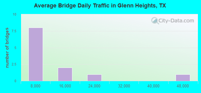
- 102,025Total average daily traffic
- 12,102Total average daily truck traffic
- National Bridge Inventory (NBI) Registered Bridges for Glenn Heights
- No street view available for this location
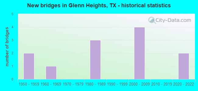
- New bridges - historical statistics
- 21950-1959
- 11960-1969
- 31980-1989
- 42000-2009
- 22020-2022
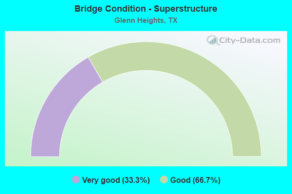
- Bridge Condition - Superstructure
- 33.3%Very good
- 66.7%Good
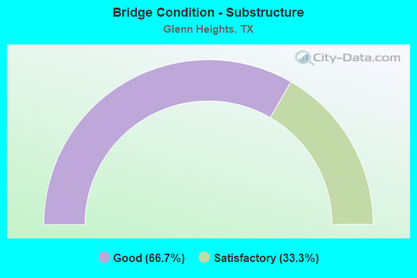
- Bridge Condition - Substructure
- 66.7%Good
- 33.3%Satisfactory
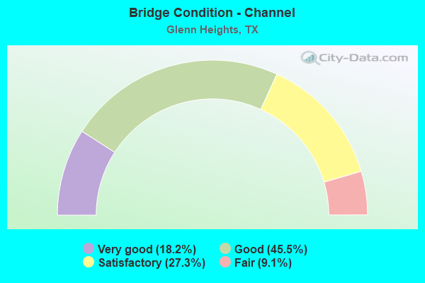
- Bridge Condition - Channel
- 18.2%Very good
- 45.5%Good
- 27.3%Satisfactory
- 9.1%Fair
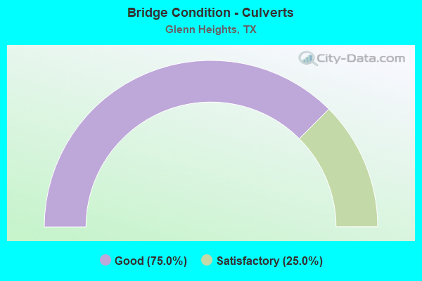
- Bridge Condition - Culverts
- 75.0%Good
- 25.0%Satisfactory
Find on map >> Show street view
Structure Number: 180570044202019, Location: 5.6 MI S OF IH 20 (Lat: 32.561042, Lng: -96.822894), Route carried "on" structure: ServiceInterstate 35, Year Built: 1960, Status: Open, Structure Length: 2.77m (9.09ft), Average Daily Traffic: 1,408 (year 2020), Truck Traffic: 5%, Average Future Daily Traffic: 1,971 (year 2040), Design Load: H 15, Features Intersected: BEAR CREEK
Minimum Vertical Clearance: 30+ m (98+ ft), Kilometerpoint: 1.770, Lanes on structure: 2, Owner: State Highway Agency, Approaching Roadway Width: 7.4m (24.3ft), Material/Design: Concrete, Design/Construction: Stringer/Multi-beam, Number Of Spans In Main Unit: 3, Length of Maximum Span: 9.1m (29.9ft), Curb-To-Curb Width: 7.5m (24.6ft), Out-to-Out Width: 7.7m (25.3ft)
Condition: Deck: Good, Superstructure: Good, Substructure: Satisfactory, Channel: Satisfactory, Operating Rating: 44.4 metric tons, Method Used To Determine Operating Rating: Load Factor (LF), Inventory Rating: 30.8 metric tons, Method Used To Determine Inventory Rating: Load Factor (LF), Structural Evaluation: Equal to present minimum criteria, Deck Geometry: High priority of replacement, Waterway Adequacy: Equal to present minimum criteria, Approach Roadway Alignment: Equal to present desirable criteria, Length Of Structure Improvement: 2.77m (9.09ft), Designated Inspection Frequency: Every 24 months, Inspection Date: October 2021, Bridge Improvement Cost: $5,000, Roadway Improvement Cost: $1,000, Total Project Cost: $6,000, Deck Structure Type: Concrete Cast-file-Place, Wearing Surface/Protective System: Wearing Surface: Bituminous
Find on map >> Show street view
Structure Number: 180570044202347, Location: 5.6 MI S OF IH 20 (Lat: 32.561433, Lng: -96.822636), Route carried "on" structure: Interstate 35, Year Built: 2008, Status: Open, Structure Length: 11.46m (37.60ft), Average Daily Traffic: 47,177 (year 2020), Truck Traffic: 16%, Average Future Daily Traffic: 94,354 (year 2040), Design Load: HS 25 or greater, Features Intersected: BEAR CREEK & BEAR CRK RD
Minimum Vertical Clearance: 30+ m (98+ ft), Kilometerpoint: 1.688, Lanes on structure: 3, Lanes under structure: 4, Base Highway Network: Yes, Owner: State Highway Agency, Approaching Roadway Width: 20.8m (68.2ft), Material/Design: Prestressed concrete, Design/Construction: Stringer/Multi-beam, Number Of Spans In Main Unit: 3, Number Of Approach Spans: 1, Length of Maximum Span: 36.0m (118.1ft), Curb-To-Curb Width: 20.8m (68.2ft), Out-to-Out Width: 21.6m (70.9ft)
Condition: Deck: Good, Superstructure: Very good, Substructure: Good, Channel: Very good, Operating Rating: 68.0 metric tons, Method Used To Determine Operating Rating: Assigned rating based on Load Factor Design (LFD) reported in metric tons, Inventory Rating: 40.8 metric tons, Method Used To Determine Inventory Rating: Assigned rating based on Load Factor Design (LFD) reported in metric tons, Structural Evaluation: Better than present minimum criteria, Deck Geometry: Superior to present desirable criteria, Underclear: Superior to present desirable criteria, Waterway Adequacy: Superior to present desirable criteria, Approach Roadway Alignment: Equal to present desirable criteria, Designated Inspection Frequency: Every 24 months, Inspection Date: October 2021, Deck Structure Type: Concrete Cast-file-Place
Find on map >> Show street view
Structure Number: 180570LK3760002, Location: 0.2 MI N of E Bear Creek (Lat: 32.563439, Lng: -96.834433), Route carried "on" structure: City street , Year Built: 2005, Status: Open, Structure Length: 1.65m (5.41ft), Average Daily Traffic: 231 (year 2019), Truck Traffic: 3%, Average Future Daily Traffic: 462 (year 2039), Features Intersected: BEAR CREEK, Facility Carried by Structure: MOURNING DOVE DR
Minimum Vertical Clearance: 30+ m (98+ ft), Kilometerpoint: 0.322, Lanes on structure: 2, Owner: City or Municipal Highway Agency, Approaching Roadway Width: 8.2m (26.9ft), Material/Design: Concrete, Design/Construction: Culvert, Number Of Spans In Main Unit: 5, Length of Maximum Span: 3.0m (9.8ft), Curb or Sidewalk Widths: Left: 1.5m (4.9ft), Right: 0.0m, Curb-To-Curb Width: 8.2m (26.9ft), Out-to-Out Width: 18.3m (60.0ft)
Condition: Channel: Good, Culverts: Good, Operating Rating: 32.7 metric tons, Method Used To Determine Operating Rating: Field evaluation and documented engineering judgment, Inventory Rating: 24.5 metric tons, Method Used To Determine Inventory Rating: Field evaluation and documented engineering judgment, Structural Evaluation: Equal to present minimum criteria, Deck Geometry: Somewhat better than minimum adequacy, Waterway Adequacy: Better than present minimum criteria, Approach Roadway Alignment: Equal to present desirable criteria, Designated Inspection Frequency: Every 24 months, Inspection Date: Febuary 2021, Deck Structure Type: Concrete Cast-file-Place, Wearing Surface/Protective System: Wearing Surface: Monolithic Concrete
Find on map >> Show street view
Structure Number: 180570Y00010001, Location: 2.7 MI S OF BELTLINE RD (Lat: 32.547764, Lng: -96.873894), Route carried "on" structure: County highway , Year Built: 1988, Status: Open, Structure Length: 5.06m (16.60ft), Average Daily Traffic: 1,779 (year 2020), Average Future Daily Traffic: 1,200 (year 2031), Features Intersected: LITTLE CREEK, Facility Carried by Structure: WESTMORELAND RD
Minimum Vertical Clearance: 30+ m (98+ ft), Kilometerpoint: 9.495, Lanes on structure: 2, Owner: City or Municipal Highway Agency, Approaching Roadway Width: 8.5m (27.9ft), Skew: 3 degrees, Material/Design: Concrete, Design/Construction: Stringer/Multi-beam, Number Of Spans In Main Unit: 5, Length of Maximum Span: 10.1m (33.1ft), Curb-To-Curb Width: 10.2m (33.5ft), Out-to-Out Width: 11.1m (36.4ft)
Condition: Deck: Good, Superstructure: Good, Substructure: Good, Channel: Satisfactory, Operating Rating: 32.7 metric tons, Method Used To Determine Operating Rating: Field evaluation and documented engineering judgment, Inventory Rating: 24.5 metric tons, Method Used To Determine Inventory Rating: Field evaluation and documented engineering judgment, Structural Evaluation: Equal to present minimum criteria, Deck Geometry: Somewhat better than minimum adequacy, Waterway Adequacy: Superior to present desirable criteria, Approach Roadway Alignment: Equal to present desirable criteria, Designated Inspection Frequency: Every 24 months, Inspection Date: January 2021, Deck Structure Type: Concrete Cast-file-Place
Find on map >> Show street view
Structure Number: 180570Y00020001, Location: 0.15 MI N OF BEAR CRK RD (Lat: 32.562939, Lng: -96.839714), Route carried "on" structure: City street , Year Built: 1986, Status: Open, Structure Length: 1.62m (5.31ft), Average Daily Traffic: 4,450 (year 2011), Average Future Daily Traffic: 6,000 (year 2031), Features Intersected: BEAR CREEK, Facility Carried by Structure: UHL RD
Minimum Vertical Clearance: 30+ m (98+ ft), Kilometerpoint: 0.241, Lanes on structure: 2, Owner: City or Municipal Highway Agency, Approaching Roadway Width: 9.8m (32.2ft), Material/Design: Concrete, Design/Construction: Culvert, Number Of Spans In Main Unit: 5, Length of Maximum Span: 3.0m (9.8ft), Curb-To-Curb Width: 12.0m (39.4ft), Out-to-Out Width: 12.6m (41.3ft)
Condition: Channel: Satisfactory, Culverts: Satisfactory, Operating Rating: 32.7 metric tons, Method Used To Determine Operating Rating: Field evaluation and documented engineering judgment, Inventory Rating: 24.5 metric tons, Method Used To Determine Inventory Rating: Field evaluation and documented engineering judgment, Structural Evaluation: Equal to present minimum criteria, Deck Geometry: Somewhat better than minimum adequacy, Waterway Adequacy: Equal to present minimum criteria, Approach Roadway Alignment: Equal to present desirable criteria, Designated Inspection Frequency: Every 24 months, Inspection Date: January 2021, Deck Structure Type: Concrete Cast-file-Place, Wearing Surface/Protective System: Wearing Surface: Bituminous
Find on map >> Show street view
Structure Number: 180570Y00020002, Location: 0.25 MI N OF BEAR CRK RD (Lat: 32.564558, Lng: -96.839725), Route carried "on" structure: City street , Year Built: 1989, Status: Open, Structure Length: 1.34m (4.40ft), Average Daily Traffic: 4,450 (year 2011), Average Future Daily Traffic: 8,500 (year 2031), Features Intersected: BEAR CREEK TRIB, Facility Carried by Structure: UHL RD
Minimum Vertical Clearance: 30+ m (98+ ft), Kilometerpoint: 0.402, Lanes on structure: 2, Owner: City or Municipal Highway Agency, Approaching Roadway Width: 9.8m (32.2ft), Skew: 3 degrees, Material/Design: Concrete, Design/Construction: Culvert, Number Of Spans In Main Unit: 4, Length of Maximum Span: 2.7m (8.9ft), Curb-To-Curb Width: 14.6m (47.9ft), Out-to-Out Width: 15.0m (49.2ft)
Condition: Channel: Fair, Culverts: Good, Operating Rating: 32.7 metric tons, Method Used To Determine Operating Rating: Field evaluation and documented engineering judgment, Inventory Rating: 24.5 metric tons, Method Used To Determine Inventory Rating: Field evaluation and documented engineering judgment, Structural Evaluation: Equal to present minimum criteria, Deck Geometry: Superior to present desirable criteria, Waterway Adequacy: Equal to present minimum criteria, Approach Roadway Alignment: Equal to present desirable criteria, Designated Inspection Frequency: Every 24 months, Inspection Date: January 2021, Deck Structure Type: Concrete Cast-file-Place, Wearing Surface/Protective System: Wearing Surface: Bituminous
Find on map >> Show street view
Structure Number: 180570Y00025002, Location: 0.3 MI E OF COCKRELL HILL (Lat: 32.560844, Lng: -96.886342), Route carried "on" structure: City street , Year Built: 1950, Year Reconstructed: 2010, Status: Open, Structure Length: 0.64m (2.10ft), Average Daily Traffic: 1,230 (year 2011), Average Future Daily Traffic: 1,800 (year 2031), Features Intersected: LITTLE CREEK TRIB, Facility Carried by Structure: BEAR CREEK RD
Minimum Vertical Clearance: 30+ m (98+ ft), Kilometerpoint: 9.543, Lanes on structure: 2, Owner: City or Municipal Highway Agency, Approaching Roadway Width: 10.1m (33.1ft), Material/Design: Concrete, Design/Construction: Culvert, Number Of Spans In Main Unit: 2, Length of Maximum Span: 3.0m (9.8ft), Curb-To-Curb Width: 8.9m (29.2ft), Out-to-Out Width: 10.7m (35.1ft)
Condition: Channel: Good, Culverts: Good, Operating Rating: 32.7 metric tons, Method Used To Determine Operating Rating: Field evaluation and documented engineering judgment, Inventory Rating: 24.5 metric tons, Method Used To Determine Inventory Rating: Field evaluation and documented engineering judgment, Structural Evaluation: Equal to present minimum criteria, Deck Geometry: Somewhat better than minimum adequacy, Waterway Adequacy: Equal to present minimum criteria, Approach Roadway Alignment: Equal to present desirable criteria, Designated Inspection Frequency: Every 24 months, Inspection Date: January 2021, Deck Structure Type: Concrete Cast-file-Place, Wearing Surface/Protective System: Wearing Surface: Bituminous
Find on map >> Show street view
Structure Number: 180570Y00025003, Location: 0.6 MI E OF COCKRELL HILL (Lat: 32.560822, Lng: -96.880639), Route carried "on" structure: City street , Year Built: 1950, Year Reconstructed: 2010, Status: Open, Structure Length: 0.67m (2.20ft), Average Daily Traffic: 1,230 (year 2011), Average Future Daily Traffic: 1,800 (year 2031), Features Intersected: LITTLE CREEK TRIB, Facility Carried by Structure: BEAR CREEK RD
Minimum Vertical Clearance: 30+ m (98+ ft), Kilometerpoint: 10.187, Lanes on structure: 2, Owner: City or Municipal Highway Agency, Approaching Roadway Width: 10.4m (34.1ft), Material/Design: Concrete, Design/Construction: Culvert, Number Of Spans In Main Unit: 3, Length of Maximum Span: 2.1m (6.9ft), Curb-To-Curb Width: 8.6m (28.2ft), Out-to-Out Width: 10.4m (34.1ft)
Condition: Channel: Good, Culverts: Satisfactory, Operating Rating: 32.7 metric tons, Method Used To Determine Operating Rating: Field evaluation and documented engineering judgment, Inventory Rating: 24.5 metric tons, Method Used To Determine Inventory Rating: Field evaluation and documented engineering judgment, Structural Evaluation: Equal to present minimum criteria, Deck Geometry: Somewhat better than minimum adequacy, Waterway Adequacy: Equal to present minimum criteria, Approach Roadway Alignment: Equal to present desirable criteria, Designated Inspection Frequency: Every 24 months, Inspection Date: January 2021, Deck Structure Type: Concrete Cast-file-Place, Wearing Surface/Protective System: Wearing Surface: Bituminous
Find on map >> Show street view
Structure Number: 180570Y01515001, Location: 0.2 MI E of S Cockrell (Lat: 32.563450, Lng: -96.887664), Route carried "on" structure: City street , Year Built: 2007, Status: Open, Structure Length: 1.83m (6.00ft), Average Daily Traffic: 231 (year 2019), Truck Traffic: 3%, Average Future Daily Traffic: 462 (year 2039), Features Intersected: TRIB LITTLE CREEK, Facility Carried by Structure: TURN BRIDGE DR
Minimum Vertical Clearance: 30+ m (98+ ft), Kilometerpoint: 0.322, Lanes on structure: 2, Owner: City or Municipal Highway Agency, Approaching Roadway Width: 11.6m (38.1ft), Skew: 1 degrees, Material/Design: Concrete, Design/Construction: Culvert, Number Of Spans In Main Unit: 6, Length of Maximum Span: 2.7m (8.9ft), Curb or Sidewalk Widths: Left: 1.8m (5.9ft), Right: 1.5m (4.9ft), Curb-To-Curb Width: 11.6m (38.1ft), Out-to-Out Width: 21.1m (69.2ft)
Condition: Channel: Very good, Culverts: Good, Operating Rating: 32.7 metric tons, Method Used To Determine Operating Rating: Field evaluation and documented engineering judgment, Inventory Rating: 24.5 metric tons, Method Used To Determine Inventory Rating: Field evaluation and documented engineering judgment, Structural Evaluation: Equal to present minimum criteria, Deck Geometry: Superior to present desirable criteria, Waterway Adequacy: Better than present minimum criteria, Approach Roadway Alignment: Equal to present desirable criteria, Designated Inspection Frequency: Every 24 months, Inspection Date: Febuary 2021, Deck Structure Type: Concrete Cast-file-Place, Wearing Surface/Protective System: Wearing Surface: Monolithic Concrete
Find on map >> Show street view
Structure Number: 180710105101416, Location: 1.60 MI W OF IH 35E (Lat: 32.531800, Lng: -96.849300), Route carried "on" structure: State highway 644, Year Built: 2020, Status: Open, Structure Length: 0.94m (3.08ft), Average Daily Traffic: 18,618 (year 2018), Truck Traffic: 15%, Average Future Daily Traffic: 10,000 (year 2030), Design Load: HL 93, Features Intersected: DRAW, Facility Carried by Structure: FM 664
Minimum Vertical Clearance: 30+ m (98+ ft), Kilometerpoint: 2.527, Lanes on structure: 2, Owner: State Highway Agency, Approaching Roadway Width: 32.6m (107.0ft), Skew: 19 degrees, Material/Design: Concrete, Design/Construction: Culvert, Number Of Spans In Main Unit: 3, Length of Maximum Span: 2.7m (8.9ft), Curb or Sidewalk Widths: Left: 1.8m (5.9ft), Right: 1.8m (5.9ft)
Condition: Channel: Good, Culverts: Good, Operating Rating: 54.4 metric tons, Method Used To Determine Operating Rating: Assigned ratings based on Load and Resistance Factor Design (LRFD) reported in metric tons, Inventory Rating: 32.7 metric tons, Method Used To Determine Inventory Rating: Assigned ratings based on Load and Resistance Factor Design (LRFD) reported in metric tons, Structural Evaluation: Better than present minimum criteria, Waterway Adequacy: Superior to present desirable criteria, Approach Roadway Alignment: Equal to present desirable criteria, Designated Inspection Frequency: Every 24 months, Inspection Date: March 2020
Find on map >> Show street view
Structure Number: 180710105101417, Location: 0.7 MI W of IH 35E (Lat: 32.531928, Lng: -96.834678), Route carried "on" structure: State highway 664, Year Built: 2020, Status: Open, Structure Length: 0.76m (2.49ft), Average Daily Traffic: 8,700 (year 2012), Truck Traffic: 15%, Average Future Daily Traffic: 10,000 (year 2030), Design Load: HL 93, Features Intersected: Draw
Minimum Vertical Clearance: 30+ m (98+ ft), Kilometerpoint: 1.127, Lanes on structure: 2, Owner: State Highway Agency, Approaching Roadway Width: 25.6m (84.0ft), Skew: 29 degrees, Material/Design: Concrete, Design/Construction: Culvert, Number Of Spans In Main Unit: 2, Length of Maximum Span: 2.7m (8.9ft), Curb or Sidewalk Widths: Left: 1.8m (5.9ft), Right: 1.8m (5.9ft), Curb-To-Curb Width: 12.2m (40.0ft), Out-to-Out Width: 40.6m (133.2ft)
Condition: Channel: Good, Culverts: Good, Operating Rating: 54.4 metric tons, Method Used To Determine Operating Rating: Assigned ratings based on Load and Resistance Factor Design (LRFD) reported in metric tons, Inventory Rating: 32.7 metric tons, Method Used To Determine Inventory Rating: Assigned ratings based on Load and Resistance Factor Design (LRFD) reported in metric tons, Structural Evaluation: Better than present minimum criteria, Deck Geometry: Somewhat better than minimum adequacy, Waterway Adequacy: Superior to present desirable criteria, Approach Roadway Alignment: Equal to present desirable criteria, Designated Inspection Frequency: Every 24 months, Inspection Date: May 2020, Deck Structure Type: Concrete Cast-file-Place, Wearing Surface/Protective System: Wearing Surface: Monolithic Concrete
Find on map >> Show street view
Structure Number: 180570044202347, Location: 5.6 MI S OF IH 20 (Lat: 32.561433, Lng: -96.822636), Route carried "under" structure: City street , Year Built: 2008, Structure Length: 0. m, Average Daily Traffic: 12,521 (year 2014), Truck Traffic: 3%, Features Intersected: BEAR CREEK RD, Facility Carried by Structure: IH 35E SB
Minimum Vertical Clearance: 5.69m (18.67ft), Kilometerpoint: 0.000, Lanes on structure: 3, Lanes under structure: 4, Material/Design: Prestressed concrete, Design/Construction: Stringer/Multi-beam, Length of Maximum Span: 36.0m (118.1ft)