Bridge Statistics for Gorham, Kansas (KS)
Condition, Traffic, Stress, Structural Evaluation, Project Costs
- National Bridge Inventory (NBI) Statistics
- 21Number of bridges
- 177ft / 53.9mTotal length
- $558,000Total costs
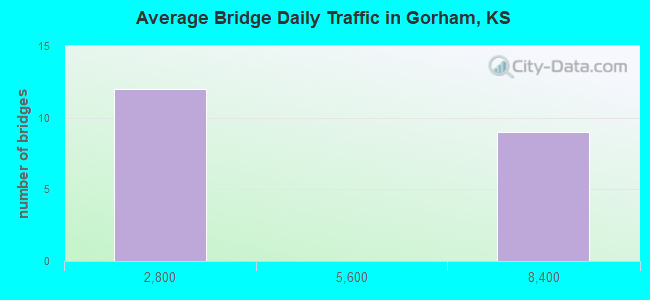
- 69,994Total average daily traffic
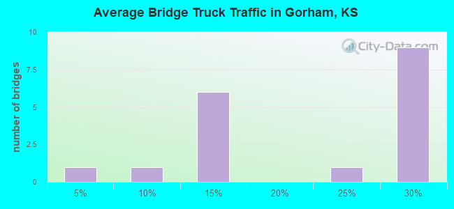
- 17,100Total average daily truck traffic
- National Bridge Inventory (NBI) Registered Bridges for Gorham
- No street view available for this location
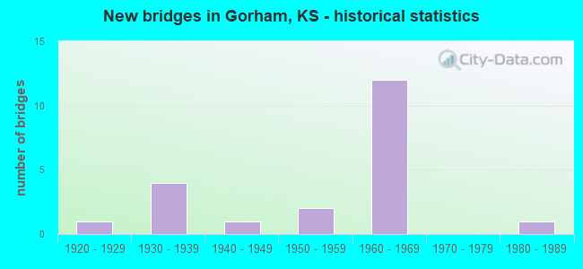
- New bridges - historical statistics
- 11920-1929
- 41930-1939
- 11940-1949
- 21950-1959
- 121960-1969
- 11980-1989
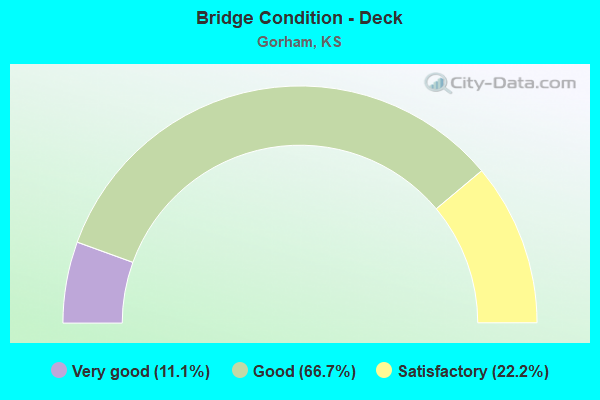
- Bridge Condition - Deck
- 11.1%Very good
- 66.7%Good
- 22.2%Satisfactory
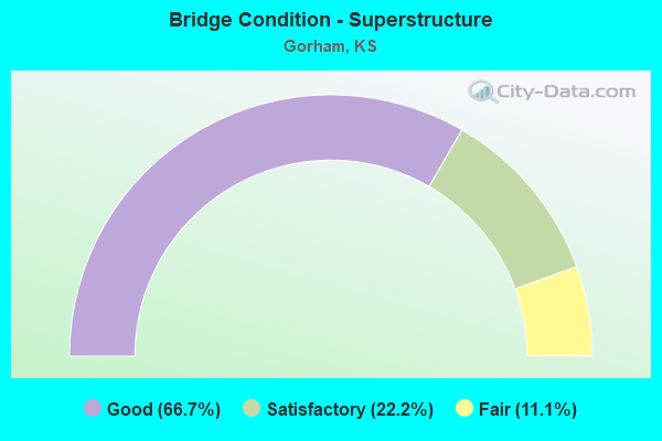
- Bridge Condition - Superstructure
- 66.7%Good
- 22.2%Satisfactory
- 11.1%Fair
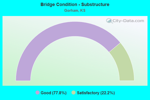
- Bridge Condition - Substructure
- 77.8%Good
- 22.2%Satisfactory
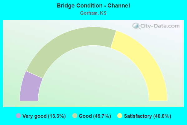
- Bridge Condition - Channel
- 13.3%Very good
- 46.7%Good
- 40.0%Satisfactory
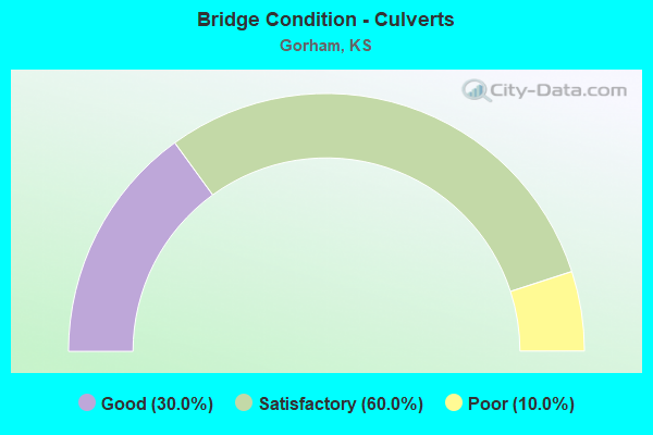
- Bridge Condition - Culverts
- 30.0%Good
- 60.0%Satisfactory
- 10.0%Poor
Find on map >> Show street view
Structure Number: 2605, Location: 2.7N OF WALKER (Lat: 38.911817, Lng: -99.076833), Route carried "on" structure: County highway 449, Year Built: 1955, Status: Posted for load, Structure Length: 0.63m (2.07ft), Average Daily Traffic: 90 (year 2014), Truck Traffic: 10%, Average Future Daily Traffic: 110 (year 2040), Design Load: H 15, Features Intersected: WALKER CREEK TRIBUTARY, Facility Carried by Structure: Walker Avenue
Minimum Vertical Clearance: 30.47m (99.97ft), Kilometerpoint: 0.000, Lanes on structure: 2, Owner: County Highway Agency, Approaching Roadway Width: 7.3m (24.0ft), Material/Design: Concrete, Design/Construction: Culvert, Number Of Spans In Main Unit: 2, Length of Maximum Span: 3.0m (9.8ft), Curb-To-Curb Width: 7.9m (25.9ft), Out-to-Out Width: 8.5m (27.9ft)
Condition: Channel: Satisfactory, Culverts: Satisfactory, Operating Rating: 25.8 metric tons, Method Used To Determine Operating Rating: Allowable Stress (AS), Inventory Rating: 14.2 metric tons, Method Used To Determine Inventory Rating: Allowable Stress (AS), Structural Evaluation: Meets minimum limits, Deck Geometry: Equal to present minimum criteria, Waterway Adequacy: Meets minimum limits, Approach Roadway Alignment: Equal to present desirable criteria, Length Of Structure Improvement: 0.91m (2.99ft), Designated Inspection Frequency: Every 24 months, Inspection Date: December 2020, Bridge Improvement Cost: $122,000, Roadway Improvement Cost: $14,000, Total Project Cost: $135,000 ( Estimate for 2016), Wearing Surface/Protective System: Wearing Surface: Gravel
Find on map >> Show street view
Structure Number: 26071, Location: 0.5N 1.3E OF WALKER (Lat: 38.873592, Lng: -99.051214), Route carried "on" structure: County highway 1910, Year Built: 1949, Year Reconstructed: 2010, Status: Open, Structure Length: 4.95m (16.24ft), Average Daily Traffic: 720 (year 2014), Truck Traffic: 10%, Average Future Daily Traffic: 865 (year 2040), Design Load: H 20, Features Intersected: WALKER CREEK, Facility Carried by Structure: Old Highway 40
Minimum Vertical Clearance: 30.47m (99.97ft), Kilometerpoint: 0.000, Lanes on structure: 2, Owner: County Highway Agency, Approaching Roadway Width: 7.3m (24.0ft), Material/Design: Concrete continuous, Design/Construction: Tee Beam, Number Of Spans In Main Unit: 4, Length of Maximum Span: 13.7m (44.9ft), Curb or Sidewalk Widths: Left: 0.6m (2.0ft), Right: 0.6m (2.0ft), Curb-To-Curb Width: 7.9m (25.9ft), Out-to-Out Width: 9.5m (31.2ft)
Condition: Deck: Satisfactory, Superstructure: Satisfactory, Substructure: Satisfactory, Channel: Good, Operating Rating: 35.1 metric tons, Method Used To Determine Operating Rating: Allowable Stress (AS), Inventory Rating: 33.3 metric tons, Method Used To Determine Inventory Rating: Allowable Stress (AS), Structural Evaluation: Equal to present minimum criteria, Deck Geometry: Somewhat better than minimum adequacy, Waterway Adequacy: Equal to present desirable criteria, Approach Roadway Alignment: Better than present minimum criteria, Designated Inspection Frequency: Every 24 months, Inspection Date: December 2020, Deck Structure Type: Concrete Cast-file-Place, Wearing Surface/Protective System: Wearing Surface: Epoxy Overlay, Deck Protection: Bituminous
Find on map >> Show street view
Structure Number: 84015, Location: 1.0E 1.8N OF GORHAM (Lat: 38.910572, Lng: -99.002333), Route carried "on" structure: County highway 515, Year Built: 1954, Status: Posted for load, Structure Length: 0.70m (2.30ft), Average Daily Traffic: 275 (year 2014), Truck Traffic: 10%, Average Future Daily Traffic: 300 (year 2040), Design Load: H 15, Features Intersected: DRY STREAM
Minimum Vertical Clearance: 30.47m (99.97ft), Kilometerpoint: 0.000, Lanes on structure: 2, Owner: County Highway Agency, Approaching Roadway Width: 7.9m (25.9ft), Material/Design: Steel, Design/Construction: Culvert, Number Of Spans In Main Unit: 1, Length of Maximum Span: 7.0m (23.0ft), Curb-To-Curb Width: 9.1m (29.9ft), Out-to-Out Width: 9.7m (31.8ft)
Condition: Channel: Good, Culverts: Good, Operating Rating: 27.9 metric tons, Method Used To Determine Operating Rating: Allowable Stress (AS), Inventory Rating: 20.7 metric tons, Method Used To Determine Inventory Rating: Allowable Stress (AS), Structural Evaluation: Equal to present minimum criteria, Deck Geometry: Equal to present minimum criteria, Waterway Adequacy: Better than present minimum criteria, Approach Roadway Alignment: Equal to present desirable criteria, Designated Inspection Frequency: Every 24 months, Inspection Date: April 2020, Wearing Surface/Protective System: Wearing Surface: Bituminous
Find on map >> Show street view
Structure Number: 84016, Location: 1.0E 3.0N OF GORHAM (Lat: 38.927647, Lng: -99.002231), Route carried "on" structure: County highway 515, Year Built: 1929, Status: Open, Structure Length: 0.79m (2.59ft), Average Daily Traffic: 250 (year 2014), Truck Traffic: 10%, Average Future Daily Traffic: 270 (year 2040), Features Intersected: DRY STREAM
Minimum Vertical Clearance: 30.47m (99.97ft), Kilometerpoint: 0.000, Lanes on structure: 2, Owner: County Highway Agency, Approaching Roadway Width: 7.3m (24.0ft), Material/Design: Concrete, Design/Construction: Culvert, Number Of Spans In Main Unit: 4, Length of Maximum Span: 1.8m (5.9ft), Curb-To-Curb Width: 8.1m (26.6ft), Out-to-Out Width: 8.7m (28.5ft)
Condition: Channel: Good, Culverts: Satisfactory, Operating Rating: 26.1 metric tons, Method Used To Determine Operating Rating: Allowable Stress (AS), Inventory Rating: 18.9 metric tons, Method Used To Determine Inventory Rating: Allowable Stress (AS), Structural Evaluation: Somewhat better than minimum adequacy, Deck Geometry: Somewhat better than minimum adequacy, Waterway Adequacy: Equal to present minimum criteria, Approach Roadway Alignment: Equal to present desirable criteria, Designated Inspection Frequency: Every 24 months, Inspection Date: April 2020, Wearing Surface/Protective System: Wearing Surface: Bituminous
Find on map >> Show street view
Structure Number: 84055, Location: 2.1S OF GORHAM (Lat: 38.847344, Lng: -99.021453), Route carried "on" structure: County highway 1457, Year Built: 1962, Status: Posted for load, Structure Length: 4.47m (14.67ft), Average Daily Traffic: 250 (year 2014), Truck Traffic: 10%, Average Future Daily Traffic: 270 (year 2040), Design Load: H 15, Features Intersected: WALKER CREEK
Minimum Vertical Clearance: 30.47m (99.97ft), Kilometerpoint: 0.000, Lanes on structure: 2, Owner: County Highway Agency, Approaching Roadway Width: 7.0m (23.0ft), Material/Design: Concrete continuous, Design/Construction: Tee Beam, Number Of Spans In Main Unit: 3, Length of Maximum Span: 16.8m (55.1ft), Curb or Sidewalk Widths: Left: 0.3m (1.0ft), Right: 0.3m (1.0ft), Curb-To-Curb Width: 7.3m (24.0ft), Out-to-Out Width: 7.9m (25.9ft)
Condition: Deck: Satisfactory, Superstructure: Satisfactory, Substructure: Good, Channel: Satisfactory, Operating Rating: 22.5 metric tons, Method Used To Determine Operating Rating: Allowable Stress (AS), Inventory Rating: 16.2 metric tons, Method Used To Determine Inventory Rating: Allowable Stress (AS), Structural Evaluation: Somewhat better than minimum adequacy, Deck Geometry: Somewhat better than minimum adequacy, Waterway Adequacy: Better than present minimum criteria, Approach Roadway Alignment: Equal to present desirable criteria, Designated Inspection Frequency: Every 24 months, Inspection Date: April 2020, Deck Structure Type: Concrete Cast-file-Place, Wearing Surface/Protective System: Wearing Surface: Bituminous
Find on map >> Show street view
Structure Number: 84056, Location: 1.3S OF GORHAM (Lat: 38.858336, Lng: -99.021389), Route carried "on" structure: County highway 1457, Year Built: 1935, Status: Posted for load, Structure Length: 0.78m (2.56ft), Average Daily Traffic: 250 (year 2014), Truck Traffic: 10%, Average Future Daily Traffic: 300 (year 2040), Features Intersected: DRY STREAM
Minimum Vertical Clearance: 30.47m (99.97ft), Kilometerpoint: 0.000, Lanes on structure: 2, Owner: County Highway Agency, Approaching Roadway Width: 7.8m (25.6ft), Material/Design: Concrete, Design/Construction: Culvert, Number Of Spans In Main Unit: 3, Length of Maximum Span: 2.4m (7.9ft), Curb-To-Curb Width: 8.2m (26.9ft), Out-to-Out Width: 9.0m (29.5ft)
Condition: Channel: Satisfactory, Culverts: Satisfactory, Operating Rating: 26.1 metric tons, Method Used To Determine Operating Rating: Allowable Stress (AS), Inventory Rating: 18.9 metric tons, Method Used To Determine Inventory Rating: Allowable Stress (AS), Structural Evaluation: Somewhat better than minimum adequacy, Deck Geometry: Somewhat better than minimum adequacy, Waterway Adequacy: Equal to present minimum criteria, Approach Roadway Alignment: Equal to present minimum criteria, Designated Inspection Frequency: Every 24 months, Inspection Date: April 2020, Wearing Surface/Protective System: Wearing Surface: Bituminous
Find on map >> Show street view
Structure Number: 84069, Location: 0.4W OF GORHAM (Lat: 38.878953, Lng: -99.029317), Route carried "on" structure: County highway 1910, Year Built: 1939, Status: Posted for load, Structure Length: 0.63m (2.07ft), Average Daily Traffic: 505 (year 2014), Truck Traffic: 20%, Average Future Daily Traffic: 550 (year 2040), Design Load: H 15, Features Intersected: DRY STREAM
Minimum Vertical Clearance: 30.47m (99.97ft), Kilometerpoint: 0.000, Lanes on structure: 2, Owner: County Highway Agency, Approaching Roadway Width: 7.3m (24.0ft), Material/Design: Concrete, Design/Construction: Culvert, Number Of Spans In Main Unit: 2, Length of Maximum Span: 3.0m (9.8ft), Curb-To-Curb Width: 10.9m (35.8ft), Out-to-Out Width: 11.7m (38.4ft)
Condition: Channel: Satisfactory, Culverts: Satisfactory, Operating Rating: 23.0 metric tons, Method Used To Determine Operating Rating: Load Factor (LF), Inventory Rating: 13.7 metric tons, Method Used To Determine Inventory Rating: Load Factor (LF), Structural Evaluation: Meets minimum limits, Deck Geometry: Equal to present minimum criteria, Waterway Adequacy: Better than present minimum criteria, Approach Roadway Alignment: Equal to present desirable criteria, Bridge Posting: Required (Relationship of Operating Rating to Maximum Legal Load: > 39.9% below), Designated Inspection Frequency: Every 24 months, Inspection Date: April 2020, Other Special Inspection Date: November 2020, Wearing Surface/Protective System: Wearing Surface: Bituminous
Find on map >> Show street view
Structure Number: 26063350452, Location: 2.0N 0.5E OF WALKER (Lat: 38.900264, Lng: -99.067239), Route carried "on" structure: County highway , Year Built: 1938, Status: Posted for load, Structure Length: 1.84m (6.04ft), Average Daily Traffic: 45 (year 2007), Truck Traffic: 5%, Average Future Daily Traffic: 55 (year 2040), Features Intersected: WALKER CREEK, Facility Carried by Structure: Vineyard Road
Minimum Vertical Clearance: 30.47m (99.97ft), Kilometerpoint: 0.000, Lanes on structure: 2, Owner: County Highway Agency, Approaching Roadway Width: 6.0m (19.7ft), Material/Design: Masonry, Design/Construction: Culvert, Number Of Spans In Main Unit: 5, Length of Maximum Span: 3.1m (10.2ft), Curb or Sidewalk Widths: Left: 0.6m (2.0ft), Right: 0.6m (2.0ft), Curb-To-Curb Width: 7.2m (23.6ft), Out-to-Out Width: 8.4m (27.6ft)
Condition: Channel: Satisfactory, Culverts: Poor, Operating Rating: 13.1 metric tons, Method Used To Determine Operating Rating: Allowable Stress (AS), Inventory Rating: 13.1 metric tons, Method Used To Determine Inventory Rating: Allowable Stress (AS), Structural Evaluation: Meets minimum limits, Deck Geometry: Somewhat better than minimum adequacy, Waterway Adequacy: Equal to present minimum criteria, Approach Roadway Alignment: Equal to present desirable criteria, Bridge Posting: Required (Relationship of Operating Rating to Maximum Legal Load: > 39.9% below), Length Of Structure Improvement: 2.44m (8.01ft), Designated Inspection Frequency: Every 24 months, Inspection Date: December 2020, Bridge Improvement Cost: $324,000, Roadway Improvement Cost: $36,000, Total Project Cost: $360,000 ( Estimate for 2016), Wearing Surface/Protective System: Wearing Surface: Gravel
Find on map >> Show street view
Structure Number: 8406398046, Location: 3.0S 0.5E OF GORHAM (Lat: 38.841642, Lng: -99.008314), Route carried "on" structure: County highway , Year Built: 1937, Status: Open, Structure Length: 1.55m (5.09ft), Average Daily Traffic: 30 (year 2014), Average Future Daily Traffic: 30 (year 2040), Features Intersected: WALKER CREEK, Facility Carried by Structure: GRANT RD.
Minimum Vertical Clearance: 30.47m (99.97ft), Kilometerpoint: 0.000, Lanes on structure: 2, Owner: County Highway Agency, Approaching Roadway Width: 6.2m (20.3ft), Material/Design: Masonry, Design/Construction: Culvert, Number Of Spans In Main Unit: 2, Length of Maximum Span: 7.3m (24.0ft), Curb-To-Curb Width: 5.0m (16.4ft), Out-to-Out Width: 5.4m (17.7ft)
Condition: Channel: Satisfactory, Culverts: Good, Operating Rating: 45.3 metric tons, Method Used To Determine Operating Rating: Allowable Stress (AS), Inventory Rating: 45.3 metric tons, Method Used To Determine Inventory Rating: Allowable Stress (AS), Structural Evaluation: Better than present minimum criteria, Waterway Adequacy: Better than present minimum criteria, Approach Roadway Alignment: Meets minimum limits, Length Of Structure Improvement: 2.01m (6.59ft), Designated Inspection Frequency: Every 24 months, Inspection Date: April 2020, Bridge Improvement Cost: $42,000, Roadway Improvement Cost: $4,000, Total Project Cost: $63,000, Wearing Surface/Protective System: Wearing Surface: Monolithic Concrete
Find on map >> Show street view
Structure Number: 840641004608, Location: 3.0S 1.0E OF GORHAM (Lat: 38.830511, Lng: -99.002919), Route carried "on" structure: County highway , Year Built: 1983, Status: Posted for load, Structure Length: 4.63m (15.19ft), Average Daily Traffic: 50 (year 2014), Average Future Daily Traffic: 50 (year 2040), Design Load: H 20, Features Intersected: WALKER CREEK, Facility Carried by Structure: 177TH ST.
Minimum Vertical Clearance: 30.47m (99.97ft), Kilometerpoint: 0.000, Lanes on structure: 2, Owner: County Highway Agency, Approaching Roadway Width: 7.3m (24.0ft), Material/Design: Prestressed concrete, Design/Construction: Tee Beam, Number Of Spans In Main Unit: 3, Length of Maximum Span: 15.2m (49.9ft), Curb-To-Curb Width: 8.5m (27.9ft), Out-to-Out Width: 9.1m (29.9ft)
Condition: Deck: Good, Superstructure: Good, Substructure: Good, Channel: Good, Operating Rating: 30.6 metric tons, Method Used To Determine Operating Rating: Allowable Stress (AS), Inventory Rating: 22.5 metric tons, Method Used To Determine Inventory Rating: Allowable Stress (AS), Structural Evaluation: Equal to present minimum criteria, Deck Geometry: Better than present minimum criteria, Waterway Adequacy: Equal to present desirable criteria, Approach Roadway Alignment: Equal to present desirable criteria, Designated Inspection Frequency: Every 24 months, Inspection Date: April 2020, Deck Structure Type: Other, Wearing Surface/Protective System: Wearing Surface: Monolithic Concrete
Find on map >> Show street view
Structure Number: 999907000260401, Location: 4.24 MI E JT K255, WB (Lat: 38.862500, Lng: -99.076667), Route carried "on" structure: Interstate 70, Year Built: 1965, Status: Open, Structure Length: 3.73m (12.24ft), Average Daily Traffic: 7,529 (year 2020), Truck Traffic: 25%, Average Future Daily Traffic: 10,548 (year 2041), Design Load: HS 20+Mod, Features Intersected: Walker Avenue
Minimum Vertical Clearance: 30.47m (99.97ft), Kilometerpoint: 46.980, Lanes on structure: 2, Lanes under structure: 2, Base Highway Network: Yes, Owner: State Highway Agency, Approaching Roadway Width: 12.2m (40.0ft), Material/Design: Concrete continuous, Design/Construction: Slab, Number Of Spans In Main Unit: 3, Length of Maximum Span: 14.6m (47.9ft), Curb-To-Curb Width: 12.2m (40.0ft), Out-to-Out Width: 12.8m (42.0ft)
Condition: Deck: Good, Superstructure: Good, Substructure: Good, Operating Rating: 59.0 metric tons, Method Used To Determine Operating Rating: Load Factor (LF), Inventory Rating: 35.4 metric tons, Method Used To Determine Inventory Rating: Load Factor (LF), Structural Evaluation: Better than present minimum criteria, Deck Geometry: Better than present minimum criteria, Underclear: Equal to present minimum criteria, Approach Roadway Alignment: Equal to present desirable criteria, Length Of Structure Improvement: 12.25m (40.19ft), Designated Inspection Frequency: Every 24 months, Inspection Date: April 2021, Deck Structure Type: Concrete Cast-file-Place, Wearing Surface/Protective System: Wearing Surface: Epoxy Overlay
Find on map >> Show street view
Structure Number: 999907000260411, Location: 4.23 MI E JT K255, EB (Lat: 38.862222, Lng: -99.076667), Route carried "on" structure: Interstate 70, Year Built: 1965, Status: Open, Structure Length: 3.73m (12.24ft), Average Daily Traffic: 7,529 (year 2020), Truck Traffic: 25%, Average Future Daily Traffic: 10,548 (year 2041), Design Load: HS 20+Mod, Features Intersected: Walker Avenue
Minimum Vertical Clearance: 30.47m (99.97ft), Kilometerpoint: 46.983, Lanes on structure: 2, Lanes under structure: 2, Base Highway Network: Yes, Owner: State Highway Agency, Approaching Roadway Width: 12.2m (40.0ft), Material/Design: Concrete continuous, Design/Construction: Slab, Number Of Spans In Main Unit: 3, Length of Maximum Span: 14.6m (47.9ft), Curb-To-Curb Width: 12.2m (40.0ft), Out-to-Out Width: 12.8m (42.0ft)
Condition: Deck: Very good, Superstructure: Good, Substructure: Good, Operating Rating: 59.0 metric tons, Method Used To Determine Operating Rating: Load Factor (LF), Inventory Rating: 35.4 metric tons, Method Used To Determine Inventory Rating: Load Factor (LF), Structural Evaluation: Better than present minimum criteria, Deck Geometry: Better than present minimum criteria, Underclear: Equal to present minimum criteria, Approach Roadway Alignment: Equal to present desirable criteria, Length Of Structure Improvement: 12.25m (40.19ft), Designated Inspection Frequency: Every 24 months, Inspection Date: April 2021, Deck Structure Type: Concrete Cast-file-Place, Wearing Surface/Protective System: Wearing Surface: Epoxy Overlay
Find on map >> Show street view
Structure Number: 999907000260421, Location: 5.90 MI E JT K255, WB (Lat: 38.863889, Lng: -99.046389), Route carried "on" structure: Interstate 70, Year Built: 1965, Status: Open, Structure Length: 4.34m (14.24ft), Average Daily Traffic: 7,529 (year 2020), Truck Traffic: 25%, Average Future Daily Traffic: 10,548 (year 2041), Design Load: HS 20+Mod, Features Intersected: WALKER CREEK
Minimum Vertical Clearance: 30.47m (99.97ft), Kilometerpoint: 49.627, Lanes on structure: 2, Base Highway Network: Yes, Owner: State Highway Agency, Approaching Roadway Width: 12.2m (40.0ft), Material/Design: Concrete continuous, Design/Construction: Slab, Number Of Spans In Main Unit: 3, Length of Maximum Span: 17.1m (56.1ft), Curb-To-Curb Width: 12.2m (40.0ft), Out-to-Out Width: 12.8m (42.0ft)
Condition: Deck: Good, Superstructure: Good, Substructure: Good, Channel: Good, Operating Rating: 63.5 metric tons, Method Used To Determine Operating Rating: Load Factor (LF), Inventory Rating: 38.1 metric tons, Method Used To Determine Inventory Rating: Load Factor (LF), Structural Evaluation: Better than present minimum criteria, Deck Geometry: Better than present minimum criteria, Waterway Adequacy: Equal to present desirable criteria, Approach Roadway Alignment: Equal to present desirable criteria, Length Of Structure Improvement: 14.25m (46.75ft), Designated Inspection Frequency: Every 24 months, Inspection Date: April 2021, Deck Structure Type: Concrete Cast-file-Place, Wearing Surface/Protective System: Wearing Surface: Low Slump Concrete
Find on map >> Show street view
Structure Number: 999907000260431, Location: 5.89 MI E JT K255, EB (Lat: 38.863611, Lng: -99.046389), Route carried "on" structure: Interstate 70, Year Built: 1965, Status: Open, Structure Length: 4.34m (14.24ft), Average Daily Traffic: 7,529 (year 2020), Truck Traffic: 25%, Average Future Daily Traffic: 10,548 (year 2041), Design Load: HS 20+Mod, Features Intersected: WALKER CREEK
Minimum Vertical Clearance: 30.47m (99.97ft), Kilometerpoint: 49.629, Lanes on structure: 2, Base Highway Network: Yes, Owner: State Highway Agency, Approaching Roadway Width: 12.2m (40.0ft), Material/Design: Concrete continuous, Design/Construction: Slab, Number Of Spans In Main Unit: 3, Length of Maximum Span: 17.1m (56.1ft), Curb-To-Curb Width: 12.2m (40.0ft), Out-to-Out Width: 12.8m (42.0ft)
Condition: Deck: Good, Superstructure: Good, Substructure: Good, Channel: Very good, Operating Rating: 63.5 metric tons, Method Used To Determine Operating Rating: Load Factor (LF), Inventory Rating: 38.1 metric tons, Method Used To Determine Inventory Rating: Load Factor (LF), Structural Evaluation: Better than present minimum criteria, Deck Geometry: Better than present minimum criteria, Waterway Adequacy: Equal to present desirable criteria, Approach Roadway Alignment: Equal to present desirable criteria, Length Of Structure Improvement: 14.25m (46.75ft), Designated Inspection Frequency: Every 24 months, Inspection Date: April 2021, Deck Structure Type: Concrete Cast-file-Place, Wearing Surface/Protective System: Wearing Surface: Low Slump Concrete
Find on map >> Show street view
Structure Number: 999907000840011, Location: 0.88MI E ELLIS CO LINE (Lat: 38.863333, Lng: -99.023056), Route carried "on" structure: Interstate 70, Year Built: 1965, Status: Open, Structure Length: 0.76m (2.49ft), Average Daily Traffic: 7,420 (year 2020), Truck Traffic: 25%, Average Future Daily Traffic: 10,395 (year 2041), Design Load: HS 20+Mod, Features Intersected: BIG CREEK DRAINAGE
Minimum Vertical Clearance: 30.47m (99.97ft), Kilometerpoint: 1.423, Lanes on structure: 6, Base Highway Network: Yes, Owner: State Highway Agency, Approaching Roadway Width: 24.4m (80.1ft), Skew: 20 degrees, Material/Design: Concrete, Design/Construction: Culvert, Number Of Spans In Main Unit: 2, Length of Maximum Span: 3.7m (12.1ft), Curb-To-Curb Width: 39.0m (128.0ft), Out-to-Out Width: 74.2m (243.4ft)
Condition: Channel: Good, Culverts: Satisfactory, Operating Rating: 54.8 metric tons, Method Used To Determine Operating Rating: Load Factor (LF), Inventory Rating: 32.8 metric tons, Method Used To Determine Inventory Rating: Load Factor (LF), Structural Evaluation: Equal to present minimum criteria, Deck Geometry: Superior to present desirable criteria, Waterway Adequacy: Better than present minimum criteria, Approach Roadway Alignment: Equal to present desirable criteria, Length Of Structure Improvement: 2.48m (8.14ft), Designated Inspection Frequency: Every 24 months, Inspection Date: April 2021, Deck Structure Type: Concrete Cast-file-Place, Wearing Surface/Protective System: Wearing Surface: Bituminous
Find on map >> Show street view
Structure Number: 999907000840021, Location: 0.99MI E ELLIS CO LINE (Lat: 38.863333, Lng: -99.021111), Route carried "on" structure: County highway 1457, Year Built: 1965, Status: Open, Structure Length: 7.33m (24.05ft), Average Daily Traffic: 291 (year 2020), Truck Traffic: 4%, Average Future Daily Traffic: 9,526 (year 2041), Design Load: H 20, Features Intersected: I70 HWY, NL-SL, Facility Carried by Structure: 176TH ST
Minimum Vertical Clearance: 30.47m (99.97ft), Kilometerpoint: 18.656, Lanes on structure: 2, Lanes under structure: 4, Owner: State Highway Agency, Approaching Roadway Width: 8.5m (27.9ft), Material/Design: Concrete continuous, Design/Construction: Box Beam or Girders - Multiple, Number Of Spans In Main Unit: 4, Length of Maximum Span: 20.7m (67.9ft), Curb-To-Curb Width: 8.5m (27.9ft), Out-to-Out Width: 10.0m (32.8ft)
Condition: Deck: Good, Superstructure: Fair, Substructure: Satisfactory, Operating Rating: 72.1 metric tons, Method Used To Determine Operating Rating: Load Factor (LF), Inventory Rating: 43.2 metric tons, Method Used To Determine Inventory Rating: Load Factor (LF), Structural Evaluation: Somewhat better than minimum adequacy, Deck Geometry: Equal to present minimum criteria, Underclear: Somewhat better than minimum adequacy, Approach Roadway Alignment: Meets minimum limits, Length Of Structure Improvement: 24.05m (78.90ft), Designated Inspection Frequency: Every 24 months, Inspection Date: April 2021, Deck Structure Type: Concrete Cast-file-Place, Wearing Surface/Protective System: Wearing Surface: Low Slump Concrete
Find on map >> Show street view
Structure Number: 999907000840031, Location: 1.17 MI E ELLIS CO LON (Lat: 38.863333, Lng: -99.018611), Route carried "on" structure: Interstate 70, Year Built: 1965, Status: Open, Structure Length: 0.63m (2.07ft), Average Daily Traffic: 7,420 (year 2020), Truck Traffic: 25%, Average Future Daily Traffic: 10,395 (year 2041), Design Load: HS 20+Mod, Features Intersected: BIG CREEK DRAINAGE
Minimum Vertical Clearance: 30.47m (99.97ft), Kilometerpoint: 1.811, Lanes on structure: 6, Base Highway Network: Yes, Owner: State Highway Agency, Approaching Roadway Width: 24.4m (80.1ft), Skew: 20 degrees, Material/Design: Concrete, Design/Construction: Culvert, Number Of Spans In Main Unit: 2, Length of Maximum Span: 3.0m (9.8ft), Curb-To-Curb Width: 36.6m (120.1ft), Out-to-Out Width: 55.3m (181.4ft)
Condition: Channel: Very good, Culverts: Satisfactory, Operating Rating: 39.0 metric tons, Method Used To Determine Operating Rating: Load Factor (LF), Inventory Rating: 23.4 metric tons, Method Used To Determine Inventory Rating: Load Factor (LF), Structural Evaluation: Somewhat better than minimum adequacy, Deck Geometry: Superior to present desirable criteria, Waterway Adequacy: Equal to present desirable criteria, Approach Roadway Alignment: Equal to present desirable criteria, Length Of Structure Improvement: 2.07m (6.79ft), Designated Inspection Frequency: Every 24 months, Inspection Date: April 2021, Deck Structure Type: Concrete Cast-file-Place, Wearing Surface/Protective System: Wearing Surface: Bituminous
Find on map >> Show street view
Structure Number: 999907000840041, Location: 2.03 MI E ELLIS CO LN (Lat: 38.863333, Lng: -99.002500), Route carried "on" structure: ServiceCounty highway 15, Year Built: 1965, Status: Open, Structure Length: 7.33m (24.05ft), Average Daily Traffic: 22 (year 2020), Average Future Daily Traffic: 9,526 (year 2041), Design Load: H 20, Features Intersected: I70 HWY, NL-SL, Facility Carried by Structure: LOCAL ROAD
Minimum Vertical Clearance: 30.47m (99.97ft), Kilometerpoint: 2.388, Lanes on structure: 2, Lanes under structure: 4, Owner: State Highway Agency, Approaching Roadway Width: 7.3m (24.0ft), Material/Design: Concrete continuous, Design/Construction: Box Beam or Girders - Multiple, Number Of Spans In Main Unit: 4, Length of Maximum Span: 20.7m (67.9ft), Curb-To-Curb Width: 8.5m (27.9ft), Out-to-Out Width: 8.9m (29.2ft)
Condition: Deck: Good, Superstructure: Good, Substructure: Good, Operating Rating: 72.1 metric tons, Method Used To Determine Operating Rating: Load Factor (LF), Inventory Rating: 43.2 metric tons, Method Used To Determine Inventory Rating: Load Factor (LF), Structural Evaluation: Better than present minimum criteria, Deck Geometry: Better than present minimum criteria, Underclear: Meets minimum limits, Approach Roadway Alignment: Somewhat better than minimum adequacy, Length Of Structure Improvement: 24.05m (78.90ft), Designated Inspection Frequency: Every 24 months, Inspection Date: April 2021, Deck Structure Type: Concrete Cast-file-Place, Wearing Surface/Protective System: Wearing Surface: Monolithic Concrete
Find on map >> Show street view
Structure Number: 999907000840051, Location: 2.53 ME E ELLIS CO LN (Lat: 38.863056, Lng: -98.993333), Route carried "on" structure: Interstate 70, Year Built: 1965, Status: Open, Structure Length: 0.76m (2.49ft), Average Daily Traffic: 7,420 (year 2020), Truck Traffic: 25%, Average Future Daily Traffic: 10,395 (year 2041), Design Load: HS 20+Mod, Features Intersected: BIG CREEK DRAINAGE
Minimum Vertical Clearance: 30.47m (99.97ft), Kilometerpoint: 4.002, Lanes on structure: 4, Base Highway Network: Yes, Owner: State Highway Agency, Approaching Roadway Width: 24.4m (80.1ft), Skew: 20 degrees, Material/Design: Concrete, Design/Construction: Culvert, Number Of Spans In Main Unit: 2, Length of Maximum Span: 3.7m (12.1ft), Curb-To-Curb Width: 24.4m (80.1ft), Out-to-Out Width: 44.3m (145.3ft)
Condition: Channel: Good, Culverts: Good, Operating Rating: 54.2 metric tons, Method Used To Determine Operating Rating: Load Factor (LF), Inventory Rating: 32.5 metric tons, Method Used To Determine Inventory Rating: Load Factor (LF), Structural Evaluation: Better than present minimum criteria, Deck Geometry: Superior to present desirable criteria, Waterway Adequacy: Equal to present desirable criteria, Approach Roadway Alignment: Equal to present desirable criteria, Length Of Structure Improvement: 2.48m (8.14ft), Designated Inspection Frequency: Every 24 months, Inspection Date: April 2021, Deck Structure Type: Concrete Cast-file-Place, Wearing Surface/Protective System: Wearing Surface: Bituminous
Find on map >> Show street view
Structure Number: 999907000840021, Location: 0.99MI E ELLIS CO LINE (Lat: 38.863333, Lng: -99.021111), Route carried "under" structure: Interstate 70, Year Built: 1965, Structure Length: 0. m, Average Daily Traffic: 7,420 (year 2020), Truck Traffic: 25%, Features Intersected: I70 HWY, NL-SL, Facility Carried by Structure: 176TH ST
Minimum Vertical Clearance: 4.95m (16.24ft), Kilometerpoint: 1.595, Lanes on structure: 2, Lanes under structure: 4, Material/Design: Concrete continuous, Design/Construction: Box Beam or Girders - Multiple, Length of Maximum Span: 20.7m (67.9ft)
Find on map >> Show street view
Structure Number: 999907000840041, Location: 2.03 MI E ELLIS CO LN (Lat: 38.863333, Lng: -99.002500), Route carried "under" structure: Interstate 70, Year Built: 1965, Structure Length: 0. m, Average Daily Traffic: 7,420 (year 2020), Truck Traffic: 25%, Features Intersected: I70 HWY, NL-SL, Facility Carried by Structure: LOCAL ROAD
Minimum Vertical Clearance: 4.75m (15.58ft), Kilometerpoint: 3.207, Lanes on structure: 2, Lanes under structure: 4, Material/Design: Concrete continuous, Design/Construction: Box Beam or Girders - Multiple, Length of Maximum Span: 20.7m (67.9ft)