Bridge Statistics for Grand Island, New York (NY)
Condition, Traffic, Stress, Structural Evaluation, Project Costs
- National Bridge Inventory (NBI) Statistics
- 30Number of bridges
- 669ft / 204mTotal length
- $160,996,000Total costs
- 340,284Total average daily traffic
- 9,477Total average daily truck traffic
- National Bridge Inventory (NBI) Registered Bridges for Grand Island
- No street view available for this location
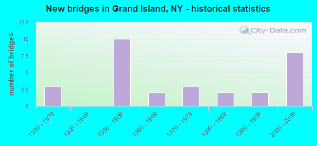
- New bridges - historical statistics
- 31930-1939
- 101950-1959
- 21960-1969
- 31970-1979
- 21980-1989
- 21990-1999
- 82000-2009
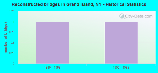
- Reconstructed bridges - Historical Statistics
- 11980-1989
- 11990-1999
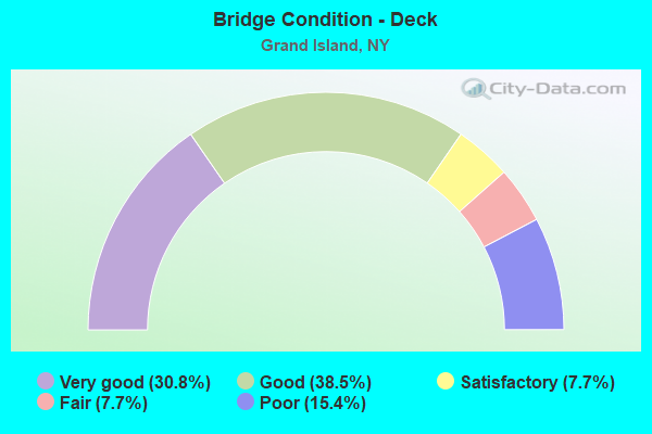
- Bridge Condition - Deck
- 30.8%Very good
- 38.5%Good
- 7.7%Satisfactory
- 7.7%Fair
- 15.4%Poor
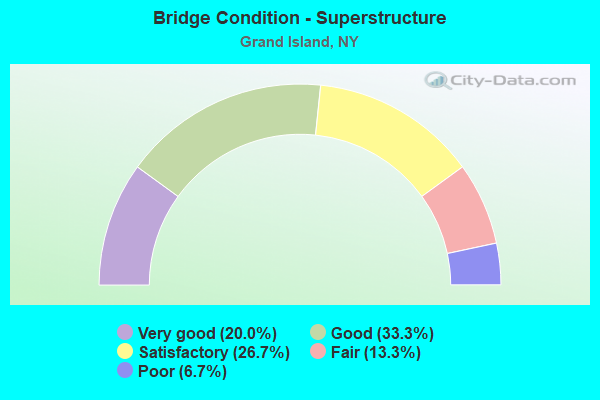
- Bridge Condition - Superstructure
- 20.0%Very good
- 33.3%Good
- 26.7%Satisfactory
- 13.3%Fair
- 6.7%Poor
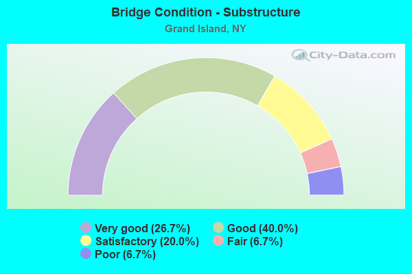
- Bridge Condition - Substructure
- 26.7%Very good
- 40.0%Good
- 20.0%Satisfactory
- 6.7%Fair
- 6.7%Poor
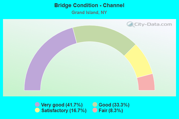
- Bridge Condition - Channel
- 41.7%Very good
- 33.3%Good
- 16.7%Satisfactory
- 8.3%Fair
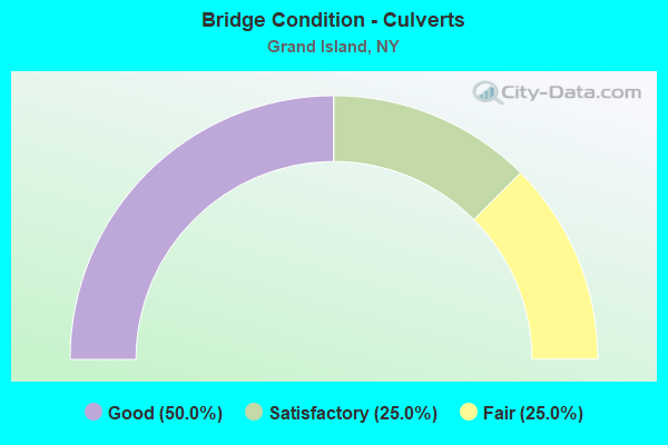
- Bridge Condition - Culverts
- 50.0%Good
- 25.0%Satisfactory
- 25.0%Fair
Find on map >> Show street view
Structure Number: 104577, Location: INT 20 ON I-190 (Lat: 43.053664, Lng: -78.990358), Route carried "on" structure: City street 957C, Year Built: 2000, Status: Open, Structure Length: 6.58m (21.59ft), Average Daily Traffic: 571 (year 2019), Truck Traffic: 1%, Average Future Daily Traffic: 706 (year 2040), Design Load: HS 25 or greater, Features Intersected: 190IX, RTE I190
Minimum Vertical Clearance: 30+ m (98+ ft), Kilometerpoint: 13.387, Lanes on structure: 2, Lanes under structure: 4, Base Highway Network: Yes, Owner: State Toll Authority, Approaching Roadway Width: 11.3m (37.1ft), Skew: 1 degrees, Material/Design: Steel continuous, Design/Construction: Stringer/Multi-beam, Number Of Spans In Main Unit: 2, Length of Maximum Span: 32.6m (107.0ft), Curb-To-Curb Width: 11.2m (36.7ft), Out-to-Out Width: 12.2m (40.0ft)
Condition: Deck: Very good, Superstructure: Very good, Substructure: Very good, Operating Rating: 41.1 metric tons, Method Used To Determine Operating Rating: Load and Resistance Factor Rating (LRFR) rating reported by rating factor(RF) method using HL-93 loadings, Inventory Rating: 31.8 metric tons, Method Used To Determine Inventory Rating: Load and Resistance Factor Rating (LRFR) rating reported by rating factor(RF) method using HL-93 loadings, Structural Evaluation: Better than present minimum criteria, Deck Geometry: Better than present minimum criteria, Underclear: High priority of corrective action, Approach Roadway Alignment: Equal to present desirable criteria, Length Of Structure Improvement: 6.58m (21.59ft), Designated Inspection Frequency: Every 24 months, Inspection Date: September 2020, Bridge Improvement Cost: $2,582,000, Roadway Improvement Cost: $1,512,000, Total Project Cost: $4,095,000 ( Estimate for 2021), Deck Structure Type: Concrete Cast-file-Place, Wearing Surface/Protective System: Wearing Surface: Integral Concrete, Deck Protection: Galvanized Reinforcing
Find on map >> Show street view
Structure Number: 1068379, Location: 0.5 MI N WHITEHAVEN RD (Lat: 43.026408, Lng: -79.011769), Route carried "on" structure: State highway 957C, Year Built: 1982, Status: Open, Structure Length: 3.20m (10.50ft), Average Daily Traffic: 571 (year 2019), Truck Traffic: 1%, Average Future Daily Traffic: 706 (year 2040), Design Load: HS 20, Features Intersected: BIG SIXMILE CREEK
Minimum Vertical Clearance: 30+ m (98+ ft), Kilometerpoint: 9.638, Lanes on structure: 4, Base Highway Network: Yes, Owner: State Park, Forest, or Reservation Agency, Maintenance Responsibility: State Highway Agency, Approaching Roadway Width: 22.9m (75.1ft), Skew: 20 degrees, Material/Design: Concrete continuous, Number Of Spans In Main Unit: 3, Length of Maximum Span: 11.8m (38.7ft), Curb or Sidewalk Widths: Left: 2.3m (7.5ft), Right: 1.5m (4.9ft), Curb-To-Curb Width: 24.7m (81.0ft), Out-to-Out Width: 29.7m (97.4ft)
Condition: Deck: Good, Superstructure: Good, Substructure: Good, Channel: Very good, Operating Rating: 79.3 metric tons, Method Used To Determine Operating Rating: Field evaluation and documented engineering judgment, Inventory Rating: 32.7 metric tons, Method Used To Determine Inventory Rating: Field evaluation and documented engineering judgment, Structural Evaluation: Better than present minimum criteria, Deck Geometry: Superior to present desirable criteria, Waterway Adequacy: Equal to present minimum criteria, Approach Roadway Alignment: Equal to present desirable criteria, Length Of Structure Improvement: 3.20m (10.50ft), Designated Inspection Frequency: Every 24 months, Inspection Date: October 2021, Bridge Improvement Cost: $3,293,000, Roadway Improvement Cost: $1,928,000, Total Project Cost: $5,221,000 ( Estimate for 2021), Wearing Surface/Protective System: Wearing Surface: Bituminous, Membrane: Other
Find on map >> Show street view
Structure Number: 226811, Location: HALF MILE BASELINE RD (Lat: 43.036514, Lng: -78.954353), Route carried "on" structure: Other road , Year Built: 1982, Status: Open, Structure Length: 0.67m (2.20ft), Average Daily Traffic: 3,245 (year 2020), Truck Traffic: 3%, Average Future Daily Traffic: 4,015 (year 2040), Features Intersected: TRIB WOODS CREEK, Facility Carried by Structure: BEDELL ROAD
Minimum Vertical Clearance: 30+ m (98+ ft), Kilometerpoint: 4.441, Lanes on structure: 2, Owner: Town or Township Highway Agency, Approaching Roadway Width: 9.8m (32.2ft), Material/Design: Steel, Design/Construction: Culvert, Number Of Spans In Main Unit: 3, Length of Maximum Span: 1.8m (5.9ft)
Condition: Channel: Fair, Culverts: Fair, Operating Rating: 73.7 metric tons, Method Used To Determine Operating Rating: Field evaluation and documented engineering judgment, Inventory Rating: 29.4 metric tons, Method Used To Determine Inventory Rating: Field evaluation and documented engineering judgment, Structural Evaluation: Somewhat better than minimum adequacy, Waterway Adequacy: Meets minimum limits, Approach Roadway Alignment: Equal to present desirable criteria, Length Of Structure Improvement: 0.67m (2.20ft), Designated Inspection Frequency: Every 24 months, Inspection Date: June 2020, Bridge Improvement Cost: $181,000, Roadway Improvement Cost: $106,000, Total Project Cost: $287,000 ( Estimate for 2021), Wearing Surface/Protective System: Wearing Surface: Bituminous
Find on map >> Show street view
Structure Number: 226812, Location: HALF MI. SOUTH WHITEHAVEN (Lat: 43.016756, Lng: -78.925478), Route carried "on" structure: Other road , Year Built: 2009, Status: Open, Structure Length: 0.67m (2.20ft), Average Daily Traffic: 500 (year 2018), Truck Traffic: 3%, Average Future Daily Traffic: 700 (year 2038), Features Intersected: SPICER CREEK, Facility Carried by Structure: HARVEY ROAD
Minimum Vertical Clearance: 30+ m (98+ ft), Kilometerpoint: 0.821, Lanes on structure: 2, Owner: Town or Township Highway Agency, Approaching Roadway Width: 6.1m (20.0ft), Material/Design: Steel, Design/Construction: Culvert, Number Of Spans In Main Unit: 3, Length of Maximum Span: 1.8m (5.9ft)
Condition: Channel: Good, Culverts: Good, Operating Rating: 73.8 metric tons, Method Used To Determine Operating Rating: Field evaluation and documented engineering judgment, Inventory Rating: 40.8 metric tons, Method Used To Determine Inventory Rating: Field evaluation and documented engineering judgment, Structural Evaluation: Better than present minimum criteria, Waterway Adequacy: Better than present minimum criteria, Approach Roadway Alignment: Equal to present desirable criteria, Length Of Structure Improvement: 0.67m (2.20ft), Designated Inspection Frequency: Every 24 months, Inspection Date: June 2021, Bridge Improvement Cost: $113,000, Roadway Improvement Cost: $66,000, Total Project Cost: $179,000 ( Estimate for 2021)
Find on map >> Show street view
Structure Number: 33265, Location: 1.6 MI N JCT SH324&B L RD (Lat: 43.048458, Lng: -78.966453), Route carried "on" structure: County highway , Year Built: 2000, Status: Open, Structure Length: 1.13m (3.71ft), Average Daily Traffic: 3,363 (year 2018), Truck Traffic: 2%, Average Future Daily Traffic: 3,551 (year 2040), Design Load: HS 25 or greater, Features Intersected: TRIB WOODS CREEK, Facility Carried by Structure: BASELINE ROAD
Minimum Vertical Clearance: 30+ m (98+ ft), Kilometerpoint: 8.125, Lanes on structure: 2, Owner: County Highway Agency, Approaching Roadway Width: 10.7m (35.1ft), Skew: 1 degrees, Material/Design: Concrete, Design/Construction: Frame, Number Of Spans In Main Unit: 1, Length of Maximum Span: 10.8m (35.4ft), Curb-To-Curb Width: 10.8m (35.4ft), Out-to-Out Width: 11.8m (38.7ft)
Condition: Deck: Very good, Superstructure: Very good, Substructure: Very good, Channel: Good, Operating Rating: 80.2 metric tons, Method Used To Determine Operating Rating: Field evaluation and documented engineering judgment, Inventory Rating: 40.8 metric tons, Method Used To Determine Inventory Rating: Field evaluation and documented engineering judgment, Structural Evaluation: Equal to present desirable criteria, Deck Geometry: Somewhat better than minimum adequacy, Waterway Adequacy: Equal to present minimum criteria, Approach Roadway Alignment: Equal to present desirable criteria, Length Of Structure Improvement: 1.12m (3.67ft), Designated Inspection Frequency: Every 24 months, Inspection Date: May 2020, Bridge Improvement Cost: $573,000, Roadway Improvement Cost: $336,000, Total Project Cost: $909,000 ( Estimate for 2021), Deck Structure Type: Concrete Cast-file-Place, Wearing Surface/Protective System: Wearing Surface: Bituminous
Find on map >> Show street view
Structure Number: 332679, Location: 1.8 MI N JCT SH324&B L RD (Lat: 43.049853, Lng: -78.966517), Route carried "on" structure: County highway , Year Built: 2000, Status: Open, Structure Length: 2.29m (7.51ft), Average Daily Traffic: 3,638 (year 2020), Truck Traffic: 2%, Average Future Daily Traffic: 4,501 (year 2040), Design Load: HS 25 or greater, Features Intersected: WOODS CREEK, Facility Carried by Structure: BASELINE ROAD
Minimum Vertical Clearance: 30+ m (98+ ft), Kilometerpoint: 8.270, Lanes on structure: 2, Owner: County Highway Agency, Approaching Roadway Width: 10.7m (35.1ft), Skew: 3 degrees, Material/Design: Prestressed concrete, Design/Construction: Box Beam or Girders - Multiple, Number Of Spans In Main Unit: 1, Length of Maximum Span: 21.9m (71.9ft), Curb-To-Curb Width: 11.6m (38.1ft), Out-to-Out Width: 12.6m (41.3ft)
Condition: Deck: Good, Superstructure: Good, Substructure: Very good, Channel: Very good, Inventory Rating: 67.1 metric tons, Method Used To Determine Inventory Rating: Load Factor (LF), Structural Evaluation: Better than present minimum criteria, Deck Geometry: Somewhat better than minimum adequacy, Waterway Adequacy: Meets minimum limits, Approach Roadway Alignment: Equal to present desirable criteria, Length Of Structure Improvement: 2.28m (7.48ft), Designated Inspection Frequency: Every 24 months, Inspection Date: May 2020, Bridge Improvement Cost: $926,000, Roadway Improvement Cost: $542,000, Total Project Cost: $1,468,000 ( Estimate for 2021), Deck Structure Type: Concrete Cast-file-Place, Wearing Surface/Protective System: Wearing Surface: Integral Concrete, Deck Protection: Epoxy Coated Reinforcing
Find on map >> Show street view
Structure Number: 336205, Location: 3.4 MI E OF I190 EXIT N19 (Lat: 43.022214, Lng: -78.909067), Route carried "on" structure: County highway , Year Built: 1970, Status: Open, Structure Length: 0.94m (3.08ft), Average Daily Traffic: 1,910 (year 2017), Truck Traffic: 4%, Average Future Daily Traffic: 2,363 (year 2040), Features Intersected: SPICER CREEK, Facility Carried by Structure: WHITEHAVEN ROAD
Minimum Vertical Clearance: 30+ m (98+ ft), Kilometerpoint: 8.801, Lanes on structure: 2, Owner: County Highway Agency, Approaching Roadway Width: 12.8m (42.0ft), Skew: 4 degrees, Material/Design: Concrete, Design/Construction: Culvert, Number Of Spans In Main Unit: 1, Length of Maximum Span: 7.6m (24.9ft)
Condition: Channel: Satisfactory, Culverts: Satisfactory, Operating Rating: 77.5 metric tons, Method Used To Determine Operating Rating: Field evaluation and documented engineering judgment, Inventory Rating: 29.4 metric tons, Method Used To Determine Inventory Rating: Field evaluation and documented engineering judgment, Structural Evaluation: Equal to present minimum criteria, Waterway Adequacy: Meets minimum limits, Approach Roadway Alignment: Equal to present desirable criteria, Length Of Structure Improvement: 0.94m (3.08ft), Designated Inspection Frequency: Every 24 months, Inspection Date: June 2020, Bridge Improvement Cost: $334,000, Roadway Improvement Cost: $196,000, Total Project Cost: $530,000 ( Estimate for 2021), Wearing Surface/Protective System: Wearing Surface: Bituminous
Find on map >> Show street view
Structure Number: 33703, Location: .3 MI E JCT CR75&W RV PKY (Lat: 43.020858, Lng: -79.009758), Route carried "on" structure: County highway , Year Built: 2004, Status: Open, Structure Length: 0.82m (2.69ft), Average Daily Traffic: 1,319 (year 2020), Truck Traffic: 4%, Average Future Daily Traffic: 1,631 (year 2040), Design Load: HS 25 or greater, Features Intersected: BIG SIX MILE CRK, Facility Carried by Structure: WHITEHAVEN ROAD
Minimum Vertical Clearance: 30+ m (98+ ft), Kilometerpoint: 0.579, Lanes on structure: 2, Owner: County Highway Agency, Approaching Roadway Width: 6.7m (22.0ft), Material/Design: Concrete, Design/Construction: Culvert, Number Of Spans In Main Unit: 2, Length of Maximum Span: 4.0m (13.1ft)
Condition: Channel: Good, Culverts: Good, Inventory Rating: 76.2 metric tons, Method Used To Determine Inventory Rating: Load Factor (LF), Structural Evaluation: Better than present minimum criteria, Waterway Adequacy: Somewhat better than minimum adequacy, Approach Roadway Alignment: Equal to present desirable criteria, Length Of Structure Improvement: 0.82m (2.69ft), Designated Inspection Frequency: Every 24 months, Inspection Date: November 2020, Bridge Improvement Cost: $153,000, Roadway Improvement Cost: $89,000, Total Project Cost: $242,000 ( Estimate for 2021)
Find on map >> Show street view
Structure Number: 5045752, Location: INT EXIT 21 ON 190I (Lat: 43.063633, Lng: -78.990600), Route carried "on" structure: Interstate 190, Year Built: 1935, Year Reconstructed: 1991, Status: Open, Structure Length: 123.38m (404.79ft), Average Daily Traffic: 14,007 (year 2018), Truck Traffic: 10%, Average Future Daily Traffic: 15,697 (year 2040), Design Load: HS 20, Features Intersected: NIAGARA RIVER, NY 957A N
Minimum Vertical Clearance: 5.33m (17.49ft), Kilometerpoint: 0.000, Lanes on structure: 2, Lanes under structure: 5, Base Highway Network: Yes, Toll: Toll bridge, Owner: State Toll Authority, Approaching Roadway Width: 11.6m (38.1ft), Navigation Control: Yes ( Vertical Clearance: 12.1m (39.7ft), Horizontal Clearance: 82.2m (269.7ft)), Material/Design: Steel continuous, Design/Construction: Truss - Deck, Number Of Spans In Main Unit: 11, Number Of Approach Spans: 5, Length of Maximum Span: 152.4m (500.0ft), Curb or Sidewalk Widths: Left: 0.0m, Right: 1.4m (4.6ft), Curb-To-Curb Width: 7.6m (24.9ft), Out-to-Out Width: 8.1m (26.6ft)
Condition: Deck: Good, Superstructure: Fair, Substructure: Good, Channel: Very good, Operating Rating: 53.5 metric tons, Method Used To Determine Operating Rating: Load Factor (LF), Inventory Rating: 32.7 metric tons, Method Used To Determine Inventory Rating: Load Factor (LF), Structural Evaluation: Somewhat better than minimum adequacy, Deck Geometry: High priority of replacement, Underclear: High priority of corrective action, Waterway Adequacy: Equal to present desirable criteria, Approach Roadway Alignment: Equal to present minimum criteria, Length Of Structure Improvement: 123.38m (404.79ft), Designated Inspection Frequency: Every 24 months, Critical Feature Inspection Frequency: Every 24 months, Underwater Inspection Frequency: Every 60 months, Inspection Date: November 2021, Critical Feature Inspection Date: November 2021, Underwater Inspection Date: October 2021, Bridge Improvement Cost: $59,210,000, Roadway Improvement Cost: $34,673,000, Total Project Cost: $93,883,000 ( Estimate for 2021), Deck Structure Type: Concrete Cast-file-Place, Wearing Surface/Protective System: Wearing Surface: Integral Concrete, Deck Protection: Epoxy Coated Reinforcing
Find on map >> Show street view
Structure Number: 5045761, Location: 1.1 MI S INT 21 ON I-90 (Lat: 43.059397, Lng: -78.990606), Route carried "on" structure: Interstate 190, Year Built: 1935, Status: Open, Structure Length: 7.62m (25.00ft), Average Daily Traffic: 28,012 (year 2014), Truck Traffic: 14%, Features Intersected: BURNT SHIP CREEK
Minimum Vertical Clearance: 30+ m (98+ ft), Kilometerpoint: 1480.393, Lanes on structure: 2, Base Highway Network: Yes, Toll: On toll road, Owner: State Toll Authority, Approaching Roadway Width: 14.6m (47.9ft), Material/Design: Concrete, Design/Construction: Arch - Deck, Number Of Spans In Main Unit: 3, Length of Maximum Span: 19.8m (65.0ft), Curb-To-Curb Width: 13.9m (45.6ft), Out-to-Out Width: 16.8m (55.1ft)
Condition: Superstructure: Fair, Substructure: Good, Channel: Very good, Operating Rating: 53.5 metric tons, Method Used To Determine Operating Rating: Field evaluation and documented engineering judgment, Inventory Rating: 13.7 metric tons, Method Used To Determine Inventory Rating: Field evaluation and documented engineering judgment, Structural Evaluation: High priority of corrective action, Deck Geometry: Superior to present desirable criteria, Waterway Adequacy: Superior to present desirable criteria, Approach Roadway Alignment: Equal to present desirable criteria, Length Of Structure Improvement: 7.62m (25.00ft), Designated Inspection Frequency: Every 24 months, Inspection Date: August 2020, Bridge Improvement Cost: $6,193,000, Roadway Improvement Cost: $3,626,000, Total Project Cost: $9,819,000 ( Estimate for 2021), Wearing Surface/Protective System: Wearing Surface: Bituminous, Membrane: Other
Find on map >> Show street view
Structure Number: 5045762, Location: 1.1 MI S INT 21 ON I-90 (Lat: 43.059406, Lng: -78.990356), Route carried "on" structure: Interstate 190, Year Built: 1963, Status: Open, Structure Length: 7.62m (25.00ft), Average Daily Traffic: 17,996 (year 2020), Truck Traffic: 14%, Average Future Daily Traffic: 20,167 (year 2040), Features Intersected: BURNT SHIP CREEK
Minimum Vertical Clearance: 30+ m (98+ ft), Kilometerpoint: 32.743, Lanes on structure: 2, Base Highway Network: Yes, Toll: On toll road, Owner: State Toll Authority, Approaching Roadway Width: 13.4m (44.0ft), Material/Design: Concrete, Design/Construction: Arch - Deck, Number Of Spans In Main Unit: 3, Length of Maximum Span: 19.8m (65.0ft), Curb-To-Curb Width: 11.4m (37.4ft), Out-to-Out Width: 14.3m (46.9ft)
Condition: Superstructure: Good, Substructure: Good, Channel: Very good, Operating Rating: 83.5 metric tons, Method Used To Determine Operating Rating: Field evaluation and documented engineering judgment, Inventory Rating: 32.7 metric tons, Method Used To Determine Inventory Rating: Field evaluation and documented engineering judgment, Structural Evaluation: Better than present minimum criteria, Deck Geometry: Somewhat better than minimum adequacy, Waterway Adequacy: Superior to present desirable criteria, Approach Roadway Alignment: Equal to present desirable criteria, Length Of Structure Improvement: 7.62m (25.00ft), Designated Inspection Frequency: Every 24 months, Inspection Date: August 2020, Bridge Improvement Cost: $5,438,000, Roadway Improvement Cost: $3,184,000, Total Project Cost: $8,622,000 ( Estimate for 2021), Wearing Surface/Protective System: Wearing Surface: Bituminous
Find on map >> Show street view
Structure Number: 504578, Location: 0.4 MI S INT 20 ON I-90 (Lat: 43.048603, Lng: -78.990344), Route carried "on" structure: County highway 324, Year Built: 1954, Year Reconstructed: 1998, Status: Open, Structure Length: 6.22m (20.41ft), Average Daily Traffic: 5,082 (year 2019), Truck Traffic: 5%, Average Future Daily Traffic: 6,287 (year 2040), Design Load: HS 20+Mod, Features Intersected: 190IX, RTE I190
Minimum Vertical Clearance: 30+ m (98+ ft), Kilometerpoint: 2.896, Lanes on structure: 3, Lanes under structure: 10, Base Highway Network: Yes, Owner: State Toll Authority, Approaching Roadway Width: 14.9m (48.9ft), Material/Design: Steel continuous, Design/Construction: Stringer/Multi-beam, Number Of Spans In Main Unit: 4, Length of Maximum Span: 19.8m (65.0ft), Curb-To-Curb Width: 14.3m (46.9ft), Out-to-Out Width: 14.9m (48.9ft)
Condition: Deck: Very good, Superstructure: Satisfactory, Substructure: Fair, Operating Rating: 56.2 metric tons, Method Used To Determine Operating Rating: Load Factor (LF), Inventory Rating: 37.2 metric tons, Method Used To Determine Inventory Rating: Load Factor (LF), Structural Evaluation: Somewhat better than minimum adequacy, Deck Geometry: Somewhat better than minimum adequacy, Underclear: High priority of corrective action, Approach Roadway Alignment: Equal to present minimum criteria, Length Of Structure Improvement: 6.21m (20.37ft), Designated Inspection Frequency: Every 24 months, Inspection Date: August 2020, Bridge Improvement Cost: $3,339,000, Roadway Improvement Cost: $1,955,000, Total Project Cost: $5,295,000 ( Estimate for 2021), Deck Structure Type: Concrete Cast-file-Place, Wearing Surface/Protective System: Wearing Surface: Integral Concrete, Deck Protection: Galvanized Reinforcing
Find on map >> Show street view
Structure Number: 50458, Location: 0.5 MI N OF S GR ISLD BRD (Lat: 43.004828, Lng: -78.948206), Route carried "on" structure: State highway 324, Year Built: 1956, Status: Open, Structure Length: 8.53m (27.99ft), Average Daily Traffic: 7,792 (year 2016), Truck Traffic: 5%, Average Future Daily Traffic: 8,228 (year 2040), Design Load: H 20, Features Intersected: 190IX SB, RTE I190
Minimum Vertical Clearance: 30+ m (98+ ft), Kilometerpoint: 8.962, Lanes on structure: 2, Lanes under structure: 5, Base Highway Network: Yes, Owner: State Toll Authority, Approaching Roadway Width: 12.5m (41.0ft), Skew: 4 degrees, Material/Design: Steel continuous, Design/Construction: Stringer/Multi-beam, Number Of Spans In Main Unit: 4, Length of Maximum Span: 26.5m (86.9ft), Curb or Sidewalk Widths: Left: 1.4m (4.6ft), Right: 1.4m (4.6ft), Curb-To-Curb Width: 9.8m (32.2ft), Out-to-Out Width: 13.1m (43.0ft)
Condition: Deck: Poor, Superstructure: Poor, Substructure: Poor, Operating Rating: 32.7 metric tons, Method Used To Determine Operating Rating: Load Factor (LF), Inventory Rating: 19.1 metric tons, Method Used To Determine Inventory Rating: Load Factor (LF), Structural Evaluation: Meets minimum limits, Deck Geometry: Meets minimum limits, Underclear: High priority of corrective action, Approach Roadway Alignment: Equal to present minimum criteria, Length Of Structure Improvement: 8.53m (27.99ft), Designated Inspection Frequency: Every 12 months, Inspection Date: October 2021, Bridge Improvement Cost: $4,013,000, Roadway Improvement Cost: $2,350,000, Total Project Cost: $6,363,000 ( Estimate for 2021), Deck Structure Type: Concrete Cast-file-Place, Wearing Surface/Protective System: Wearing Surface: Bituminous
Find on map >> Show street view
Structure Number: 55117, Location: 0.3 MI W NW SANDY BEACH (Lat: 43.056606, Lng: -78.971622), Route carried "on" structure: State lands road , Year Built: 1957, Status: Open, Structure Length: 1.95m (6.40ft), Average Daily Traffic: 1,272 (year 2020), Truck Traffic: 2%, Average Future Daily Traffic: 1,573 (year 2040), Design Load: H 20, Features Intersected: WOODS CREEK, Facility Carried by Structure: EAST WEST ROAD
Minimum Vertical Clearance: 30+ m (98+ ft), Kilometerpoint: 1.464, Lanes on structure: 2, Owner: State Park, Forest, or Reservation Agency, Approaching Roadway Width: 7.6m (24.9ft), Material/Design: Steel, Design/Construction: Stringer/Multi-beam, Number Of Spans In Main Unit: 1, Length of Maximum Span: 18.2m (59.7ft), Curb or Sidewalk Widths: Left: 1.6m (5.2ft), Right: 1.6m (5.2ft), Curb-To-Curb Width: 7.3m (24.0ft), Out-to-Out Width: 11.1m (36.4ft)
Condition: Deck: Good, Superstructure: Good, Substructure: Satisfactory, Channel: Good, Operating Rating: 43.4 metric tons, Method Used To Determine Operating Rating: Load and Resistance Factor Rating (LRFR) rating reported by rating factor(RF) method using HL-93 loadings, Inventory Rating: 33.4 metric tons, Method Used To Determine Inventory Rating: Load and Resistance Factor Rating (LRFR) rating reported by rating factor(RF) method using HL-93 loadings, Structural Evaluation: Equal to present minimum criteria, Deck Geometry: Meets minimum limits, Waterway Adequacy: Somewhat better than minimum adequacy, Approach Roadway Alignment: Equal to present minimum criteria, Length Of Structure Improvement: 1.95m (6.40ft), Designated Inspection Frequency: Every 24 months, Inspection Date: October 2020, Bridge Improvement Cost: $1,003,000, Roadway Improvement Cost: $588,000, Total Project Cost: $1,591,000 ( Estimate for 2021), Deck Structure Type: Concrete Cast-file-Place, Wearing Surface/Protective System: Wearing Surface: Bituminous
Find on map >> Show street view
Structure Number: 551171, Location: 1.2 MI S JCT W R RD(Lat: 42.961908, Lng: -78.962700), Route carried "on" structure: State lands road , Year Built: 1954, Status: Open, Structure Length: 1.43m (4.69ft), Average Daily Traffic: 54 (year 2018), Truck Traffic: 1%, Average Future Daily Traffic: 76 (year 2038), Design Load: H 20, Features Intersected: SIDE CH NAIGARARV, Facility Carried by Structure: BEAVER IS PARK RD
Minimum Vertical Clearance: 30+ m (98+ ft), Kilometerpoint: 0.177, Lanes on structure: 2, Owner: State Park, Forest, or Reservation Agency, Approaching Roadway Width: 7.3m (24.0ft), Material/Design: Steel, Design/Construction: Stringer/Multi-beam, Number Of Spans In Main Unit: 1, Length of Maximum Span: 13.7m (44.9ft), Curb or Sidewalk Widths: Left: 1.6m (5.2ft), Right: 1.6m (5.2ft), Curb-To-Curb Width: 7.3m (24.0ft), Out-to-Out Width: 11.1m (36.4ft)
Condition: Deck: Good, Superstructure: Satisfactory, Substructure: Satisfactory, Channel: Satisfactory, Operating Rating: 53.5 metric tons, Method Used To Determine Operating Rating: Load and Resistance Factor Rating (LRFR) rating reported by rating factor(RF) method using HL-93 loadings, Inventory Rating: 41.1 metric tons, Method Used To Determine Inventory Rating: Load and Resistance Factor Rating (LRFR) rating reported by rating factor(RF) method using HL-93 loadings, Structural Evaluation: Equal to present minimum criteria, Deck Geometry: Equal to present minimum criteria, Waterway Adequacy: Somewhat better than minimum adequacy, Approach Roadway Alignment: Equal to present desirable criteria, Length Of Structure Improvement: 1.43m (4.69ft), Designated Inspection Frequency: Every 24 months, Inspection Date: October 2020, Bridge Improvement Cost: $774,000, Roadway Improvement Cost: $454,000, Total Project Cost: $1,228,000 ( Estimate for 2021), Deck Structure Type: Concrete Cast-file-Place, Wearing Surface/Protective System: Wearing Surface: Bituminous
Structure Number: 551171, Location: 1.2 MI S JCT W R RD
Minimum Vertical Clearance: 30+ m (98+ ft), Kilometerpoint: 0.177, Lanes on structure: 2, Owner: State Park, Forest, or Reservation Agency, Approaching Roadway Width: 7.3m (24.0ft), Material/Design: Steel, Design/Construction: Stringer/Multi-beam, Number Of Spans In Main Unit: 1, Length of Maximum Span: 13.7m (44.9ft), Curb or Sidewalk Widths: Left: 1.6m (5.2ft), Right: 1.6m (5.2ft), Curb-To-Curb Width: 7.3m (24.0ft), Out-to-Out Width: 11.1m (36.4ft)
Condition: Deck: Good, Superstructure: Satisfactory, Substructure: Satisfactory, Channel: Satisfactory, Operating Rating: 53.5 metric tons, Method Used To Determine Operating Rating: Load and Resistance Factor Rating (LRFR) rating reported by rating factor(RF) method using HL-93 loadings, Inventory Rating: 41.1 metric tons, Method Used To Determine Inventory Rating: Load and Resistance Factor Rating (LRFR) rating reported by rating factor(RF) method using HL-93 loadings, Structural Evaluation: Equal to present minimum criteria, Deck Geometry: Equal to present minimum criteria, Waterway Adequacy: Somewhat better than minimum adequacy, Approach Roadway Alignment: Equal to present desirable criteria, Length Of Structure Improvement: 1.43m (4.69ft), Designated Inspection Frequency: Every 24 months, Inspection Date: October 2020, Bridge Improvement Cost: $774,000, Roadway Improvement Cost: $454,000, Total Project Cost: $1,228,000 ( Estimate for 2021), Deck Structure Type: Concrete Cast-file-Place, Wearing Surface/Protective System: Wearing Surface: Bituminous
Find on map >> Show street view
Structure Number: 55127, Location: 0.4 MI NW JCT I190LS PKWY (Lat: 43.007222, Lng: -78.953642), Route carried "on" structure: Other road , Year Built: 1990, Status: Open, Structure Length: 10.12m (33.20ft), Average Daily Traffic: 2,766 (year 2017), Truck Traffic: 4%, Average Future Daily Traffic: 3,422 (year 2040), Design Load: HS 20, Features Intersected: 190IX, RTE I190, Facility Carried by Structure: STALEY RD
Minimum Vertical Clearance: 30+ m (98+ ft), Kilometerpoint: 5.294, Lanes on structure: 2, Lanes under structure: 4, Owner: State Toll Authority, Approaching Roadway Width: 9.4m (30.8ft), Skew: 6 degrees, Material/Design: Steel continuous, Design/Construction: Stringer/Multi-beam, Number Of Spans In Main Unit: 2, Length of Maximum Span: 48.8m (160.1ft), Curb-To-Curb Width: 9.4m (30.8ft), Out-to-Out Width: 10.1m (33.1ft)
Condition: Deck: Satisfactory, Superstructure: Very good, Substructure: Good, Operating Rating: 88.0 metric tons, Method Used To Determine Operating Rating: Load Factor (LF), Inventory Rating: 52.6 metric tons, Method Used To Determine Inventory Rating: Load Factor (LF), Structural Evaluation: Better than present minimum criteria, Deck Geometry: Meets minimum limits, Underclear: High priority of corrective action, Approach Roadway Alignment: Equal to present desirable criteria, Length Of Structure Improvement: 10.11m (33.17ft), Designated Inspection Frequency: Every 24 months, Inspection Date: May 2020, Bridge Improvement Cost: $4,497,000, Roadway Improvement Cost: $2,634,000, Total Project Cost: $7,131,000 ( Estimate for 2021), Deck Structure Type: Concrete Cast-file-Place, Wearing Surface/Protective System: Wearing Surface: Integral Concrete, Deck Protection: Epoxy Coated Reinforcing
Find on map >> Show street view
Structure Number: 551271, Location: 1 MI NW EXIT 18 OF I190 (Lat: 43.012053, Lng: -78.965367), Route carried "on" structure: County highway , Year Built: 2000, Status: Open, Structure Length: 7.47m (24.51ft), Average Daily Traffic: 4,613 (year 2020), Truck Traffic: 3%, Average Future Daily Traffic: 4,871 (year 2040), Design Load: HS 25 or greater, Features Intersected: 190IX SB, RTE I190, Facility Carried by Structure: BASELINE RD
Minimum Vertical Clearance: 30+ m (98+ ft), Kilometerpoint: 4.039, Lanes on structure: 2, Lanes under structure: 4, Owner: State Toll Authority, Approaching Roadway Width: 10.7m (35.1ft), Skew: 3 degrees, Material/Design: Steel continuous, Design/Construction: Stringer/Multi-beam, Number Of Spans In Main Unit: 2, Length of Maximum Span: 36.9m (121.1ft), Curb-To-Curb Width: 10.8m (35.4ft), Out-to-Out Width: 11.7m (38.4ft)
Condition: Deck: Very good, Superstructure: Good, Substructure: Very good, Operating Rating: 50.5 metric tons, Method Used To Determine Operating Rating: Load and Resistance Factor Rating (LRFR) rating reported by rating factor(RF) method using HL-93 loadings, Inventory Rating: 38.9 metric tons, Method Used To Determine Inventory Rating: Load and Resistance Factor Rating (LRFR) rating reported by rating factor(RF) method using HL-93 loadings, Structural Evaluation: Better than present minimum criteria, Deck Geometry: Somewhat better than minimum adequacy, Underclear: High priority of corrective action, Approach Roadway Alignment: Equal to present desirable criteria, Length Of Structure Improvement: 7.46m (24.48ft), Designated Inspection Frequency: Every 24 months, Inspection Date: September 2020, Bridge Improvement Cost: $3,024,000, Roadway Improvement Cost: $1,771,000, Total Project Cost: $4,794,000 ( Estimate for 2021), Deck Structure Type: Concrete Cast-file-Place, Wearing Surface/Protective System: Wearing Surface: Integral Concrete, Deck Protection: Galvanized Reinforcing
Find on map >> Show street view
Structure Number: 551272, Location: 2.0 MI NW JCT I190(Lat: 43.021553, Lng: -78.974289), Route carried "on" structure: County highway , Year Built: 1955, Status: Open, Structure Length: 6.83m (22.41ft), Average Daily Traffic: 5,390 (year 2019), Truck Traffic: 6%, Average Future Daily Traffic: 6,669 (year 2040), Design Load: HS 20+Mod, Features Intersected: 190IX NB, RTE I190, Facility Carried by Structure: WHITEHAVEN RD
Minimum Vertical Clearance: 30+ m (98+ ft), Kilometerpoint: 3.427, Lanes on structure: 3, Lanes under structure: 4, Owner: State Toll Authority, Approaching Roadway Width: 11.0m (36.1ft), Skew: 2 degrees, Material/Design: Steel continuous, Design/Construction: Stringer/Multi-beam, Number Of Spans In Main Unit: 4, Length of Maximum Span: 19.8m (65.0ft), Curb or Sidewalk Widths: Left: 1.6m (5.2ft), Right: 1.6m (5.2ft), Curb-To-Curb Width: 11.0m (36.1ft), Out-to-Out Width: 14.6m (47.9ft)
Condition: Deck: Poor, Superstructure: Satisfactory, Substructure: Satisfactory, Operating Rating: 49.0 metric tons, Method Used To Determine Operating Rating: Load Factor (LF), Inventory Rating: 21.8 metric tons, Method Used To Determine Inventory Rating: Load Factor (LF), Structural Evaluation: Somewhat better than minimum adequacy, Deck Geometry: High priority of replacement, Underclear: High priority of corrective action, Approach Roadway Alignment: Equal to present minimum criteria, Length Of Structure Improvement: 6.82m (22.38ft), Designated Inspection Frequency: Every 24 months, Inspection Date: November 2020, Bridge Improvement Cost: $3,498,000, Roadway Improvement Cost: $2,049,000, Total Project Cost: $5,547,000 ( Estimate for 2021), Deck Structure Type: Concrete Cast-file-Place, Wearing Surface/Protective System: Wearing Surface: Bituminous, Membrane: Other
Structure Number: 551272, Location: 2.0 MI NW JCT I190
Minimum Vertical Clearance: 30+ m (98+ ft), Kilometerpoint: 3.427, Lanes on structure: 3, Lanes under structure: 4, Owner: State Toll Authority, Approaching Roadway Width: 11.0m (36.1ft), Skew: 2 degrees, Material/Design: Steel continuous, Design/Construction: Stringer/Multi-beam, Number Of Spans In Main Unit: 4, Length of Maximum Span: 19.8m (65.0ft), Curb or Sidewalk Widths: Left: 1.6m (5.2ft), Right: 1.6m (5.2ft), Curb-To-Curb Width: 11.0m (36.1ft), Out-to-Out Width: 14.6m (47.9ft)
Condition: Deck: Poor, Superstructure: Satisfactory, Substructure: Satisfactory, Operating Rating: 49.0 metric tons, Method Used To Determine Operating Rating: Load Factor (LF), Inventory Rating: 21.8 metric tons, Method Used To Determine Inventory Rating: Load Factor (LF), Structural Evaluation: Somewhat better than minimum adequacy, Deck Geometry: High priority of replacement, Underclear: High priority of corrective action, Approach Roadway Alignment: Equal to present minimum criteria, Length Of Structure Improvement: 6.82m (22.38ft), Designated Inspection Frequency: Every 24 months, Inspection Date: November 2020, Bridge Improvement Cost: $3,498,000, Roadway Improvement Cost: $2,049,000, Total Project Cost: $5,547,000 ( Estimate for 2021), Deck Structure Type: Concrete Cast-file-Place, Wearing Surface/Protective System: Wearing Surface: Bituminous, Membrane: Other
Find on map >> Show street view
Structure Number: 551627, Location: 1.3 MI S JCT WR PKWY(Lat: 43.036036, Lng: -78.984264), Route carried "on" structure: Other road , Year Built: 1954, Status: Open, Structure Length: 6.58m (21.59ft), Average Daily Traffic: 976 (year 2020), Truck Traffic: 1%, Average Future Daily Traffic: 1,366 (year 2040), Design Load: HS 20+Mod, Features Intersected: 190IX NB, RTE I190, Facility Carried by Structure: BEDELL RD
Minimum Vertical Clearance: 30+ m (98+ ft), Kilometerpoint: 1.979, Lanes on structure: 2, Lanes under structure: 4, Owner: State Toll Authority, Approaching Roadway Width: 7.9m (25.9ft), Skew: 2 degrees, Material/Design: Steel continuous, Design/Construction: Stringer/Multi-beam, Number Of Spans In Main Unit: 4, Length of Maximum Span: 19.8m (65.0ft), Curb-To-Curb Width: 7.9m (25.9ft), Out-to-Out Width: 10.1m (33.1ft)
Condition: Deck: Fair, Superstructure: Satisfactory, Substructure: Good, Operating Rating: 38.1 metric tons, Method Used To Determine Operating Rating: Load Factor (LF), Inventory Rating: 22.7 metric tons, Method Used To Determine Inventory Rating: Load Factor (LF), Structural Evaluation: Equal to present minimum criteria, Deck Geometry: Somewhat better than minimum adequacy, Underclear: High priority of corrective action, Approach Roadway Alignment: Equal to present minimum criteria, Length Of Structure Improvement: 6.58m (21.59ft), Designated Inspection Frequency: Every 24 months, Inspection Date: June 2020, Bridge Improvement Cost: $2,391,000, Roadway Improvement Cost: $1,400,000, Total Project Cost: $3,792,000 ( Estimate for 2021), Deck Structure Type: Concrete Cast-file-Place, Wearing Surface/Protective System: Wearing Surface: Bituminous
Structure Number: 551627, Location: 1.3 MI S JCT WR PKWY
Minimum Vertical Clearance: 30+ m (98+ ft), Kilometerpoint: 1.979, Lanes on structure: 2, Lanes under structure: 4, Owner: State Toll Authority, Approaching Roadway Width: 7.9m (25.9ft), Skew: 2 degrees, Material/Design: Steel continuous, Design/Construction: Stringer/Multi-beam, Number Of Spans In Main Unit: 4, Length of Maximum Span: 19.8m (65.0ft), Curb-To-Curb Width: 7.9m (25.9ft), Out-to-Out Width: 10.1m (33.1ft)
Condition: Deck: Fair, Superstructure: Satisfactory, Substructure: Good, Operating Rating: 38.1 metric tons, Method Used To Determine Operating Rating: Load Factor (LF), Inventory Rating: 22.7 metric tons, Method Used To Determine Inventory Rating: Load Factor (LF), Structural Evaluation: Equal to present minimum criteria, Deck Geometry: Somewhat better than minimum adequacy, Underclear: High priority of corrective action, Approach Roadway Alignment: Equal to present minimum criteria, Length Of Structure Improvement: 6.58m (21.59ft), Designated Inspection Frequency: Every 24 months, Inspection Date: June 2020, Bridge Improvement Cost: $2,391,000, Roadway Improvement Cost: $1,400,000, Total Project Cost: $3,792,000 ( Estimate for 2021), Deck Structure Type: Concrete Cast-file-Place, Wearing Surface/Protective System: Wearing Surface: Bituminous
Find on map >> Show street view
Structure Number: 104577, Location: INT 20 ON I-190 (Lat: 43.053664, Lng: -78.990358), Route carried "under" structure: Interstate 190, Year Built: 2000, Structure Length: 0. m, Average Daily Traffic: 31,697 (year 1988), Features Intersected: 190IX, RTE I190, Facility Carried by Structure: RTE 957C
Minimum Vertical Clearance: 4.65m (15.26ft), Kilometerpoint: 1479.749, Lanes on structure: 2, Lanes under structure: 2, Material/Design: Steel continuous, Design/Construction: Stringer/Multi-beam, Length of Maximum Span: 32.6m (107.0ft)
Find on map >> Show street view
Structure Number: 106838, Location: JCT LOVE ROAD & S PARKWAY (Lat: 42.995772, Lng: -78.954547), Route carried "under" structure: State highway , Year Built: 1970, Structure Length: 0. m, Features Intersected: 957B957B53011020, RTE 95, Facility Carried by Structure: PEDESTRIAN BRIDGE
Minimum Vertical Clearance: 4.65m (15.26ft), Kilometerpoint: 3.121, Lanes under structure: 3, Material/Design: Steel, Design/Construction: Stringer/Multi-beam, Length of Maximum Span: 39.3m (128.9ft)
Find on map >> Show street view
Structure Number: 106838, Location: JCT LOVE ROAD & S PARKWAY (Lat: 42.995772, Lng: -78.954547), Route carried "under" structure: State highway 957B, Year Built: 1970, Structure Length: 0. m, Average Daily Traffic: 4,857 (year 2002), Features Intersected: 957B957B53011020, RTE 95, Facility Carried by Structure: PEDESTRIAN BRIDGE
Minimum Vertical Clearance: 4.62m (15.16ft), Kilometerpoint: 3.121, Lanes under structure: 4, Material/Design: Steel, Design/Construction: Stringer/Multi-beam, Length of Maximum Span: 39.3m (128.9ft)
Find on map >> Show street view
Structure Number: 5045751, Location: INT EXIT 21 ON 190I (Lat: 43.063739, Lng: -78.990908), Route carried "under" structure: City street , Year Built: 1963, Structure Length: 0. m, Average Daily Traffic: 10,660 (year 1977), Features Intersected: NIAGARA RIVER, NY 957A N, Facility Carried by Structure: RTE I190
Minimum Vertical Clearance: 4.19m (13.75ft), Kilometerpoint: 0.000, Lanes on structure: 2, Lanes under structure: 5, Material/Design: Steel continuous, Design/Construction: Truss - Deck, Length of Maximum Span: 152.4m (500.0ft)
Find on map >> Show street view
Structure Number: 5045752, Location: INT EXIT 21 ON 190I (Lat: 43.063633, Lng: -78.990600), Route carried "under" structure: City street , Year Built: 1935, Structure Length: 0. m, Average Daily Traffic: 10,660 (year 1977), Features Intersected: NIAGARA RIVER, NY 957A N, Facility Carried by Structure: RTE I190
Minimum Vertical Clearance: 4.09m (13.42ft), Kilometerpoint: 0.000, Lanes on structure: 2, Lanes under structure: 5, Material/Design: Steel continuous, Design/Construction: Truss - Deck, Length of Maximum Span: 152.4m (500.0ft)
Find on map >> Show street view
Structure Number: 504578, Location: 0.4 MI S INT 20 ON I-90 (Lat: 43.048603, Lng: -78.990344), Route carried "under" structure: Interstate 190, Year Built: 1954, Structure Length: 0. m, Average Daily Traffic: 19,900 (year 1971), Features Intersected: 190IX, RTE I190, Facility Carried by Structure: RTE 324
Minimum Vertical Clearance: 4.60m (15.09ft), Kilometerpoint: 31.086, Lanes on structure: 3, Lanes under structure: 5, Material/Design: Steel continuous, Design/Construction: Stringer/Multi-beam, Length of Maximum Span: 19.8m (65.0ft)
Find on map >> Show street view
Structure Number: 50458, Location: 0.5 MI N OF S GR ISLD BRD (Lat: 43.004828, Lng: -78.948206), Route carried "under" structure: Interstate 190, Year Built: 1956, Structure Length: 0. m, Average Daily Traffic: 69,433 (year 2015), Features Intersected: 190IX SB, RTE I190, Facility Carried by Structure: RTE 324
Minimum Vertical Clearance: 4.52m (14.83ft), Kilometerpoint: 1472.975, Lanes on structure: 2, Lanes under structure: 3, Material/Design: Steel continuous, Design/Construction: Stringer/Multi-beam, Length of Maximum Span: 26.5m (86.9ft)
Find on map >> Show street view
Structure Number: 55127, Location: 0.4 MI NW JCT I190LS PKWY (Lat: 43.007222, Lng: -78.953642), Route carried "under" structure: Interstate 190, Year Built: 1990, Structure Length: 0. m, Average Daily Traffic: 23,400 (year 1977), Features Intersected: 190IX, RTE I190, Facility Carried by Structure: STALEY RD
Minimum Vertical Clearance: 4.57m (14.99ft), Kilometerpoint: 1473.474, Lanes on structure: 2, Lanes under structure: 2, Material/Design: Steel continuous, Design/Construction: Stringer/Multi-beam, Length of Maximum Span: 48.8m (160.1ft)
Find on map >> Show street view
Structure Number: 551271, Location: 1 MI NW EXIT 18 OF I190 (Lat: 43.012053, Lng: -78.965367), Route carried "under" structure: Interstate 190, Year Built: 2000, Structure Length: 0. m, Average Daily Traffic: 23,400 (year 1977), Features Intersected: 190IX SB, RTE I190, Facility Carried by Structure: BASELINE RD
Minimum Vertical Clearance: 4.62m (15.16ft), Kilometerpoint: 1474.584, Lanes on structure: 2, Lanes under structure: 2, Material/Design: Steel continuous, Design/Construction: Stringer/Multi-beam, Length of Maximum Span: 36.9m (121.1ft)
Find on map >> Show street view
Structure Number: 551272, Location: 2.0 MI NW JCT I190(Lat: 43.021553, Lng: -78.974289), Route carried "under" structure: Interstate 190, Year Built: 1955, Structure Length: 0. m, Average Daily Traffic: 22,200 (year 1977), Features Intersected: 190IX NB, RTE I190, Facility Carried by Structure: WHITEHAVEN RD
Minimum Vertical Clearance: 4.52m (14.83ft), Kilometerpoint: 27.787, Lanes on structure: 3, Lanes under structure: 2, Material/Design: Steel continuous, Design/Construction: Stringer/Multi-beam, Length of Maximum Span: 19.8m (65.0ft)
Structure Number: 551272, Location: 2.0 MI NW JCT I190
Minimum Vertical Clearance: 4.52m (14.83ft), Kilometerpoint: 27.787, Lanes on structure: 3, Lanes under structure: 2, Material/Design: Steel continuous, Design/Construction: Stringer/Multi-beam, Length of Maximum Span: 19.8m (65.0ft)
Find on map >> Show street view
Structure Number: 551627, Location: 1.3 MI S JCT WR PKWY(Lat: 43.036036, Lng: -78.984264), Route carried "under" structure: Interstate 190, Year Built: 1954, Structure Length: 0. m, Average Daily Traffic: 21,000 (year 1975), Features Intersected: 190IX NB, RTE I190, Facility Carried by Structure: BEDELL RD
Minimum Vertical Clearance: 4.42m (14.50ft), Kilometerpoint: 1477.690, Lanes on structure: 2, Lanes under structure: 2, Material/Design: Steel continuous, Design/Construction: Stringer/Multi-beam, Length of Maximum Span: 19.8m (65.0ft)
Structure Number: 551627, Location: 1.3 MI S JCT WR PKWY
Minimum Vertical Clearance: 4.42m (14.50ft), Kilometerpoint: 1477.690, Lanes on structure: 2, Lanes under structure: 2, Material/Design: Steel continuous, Design/Construction: Stringer/Multi-beam, Length of Maximum Span: 19.8m (65.0ft)