Bridge Statistics for Grand Mound, Iowa (IA)
Condition, Traffic, Stress, Structural Evaluation, Project Costs
- National Bridge Inventory (NBI) Statistics
- 16Number of bridges
- 102ft / 31.2mTotal length
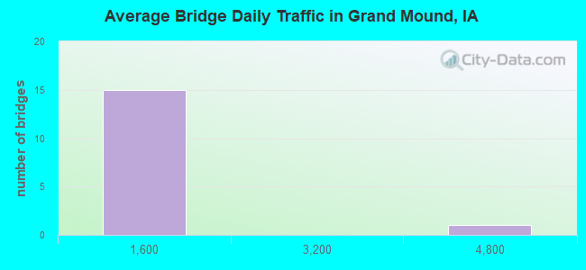
- 7,100Total average daily traffic
- 751Total average daily truck traffic
- 7,100Total future (year 2040) average daily traffic
- National Bridge Inventory (NBI) Registered Bridges for Grand Mound
- No street view available for this location
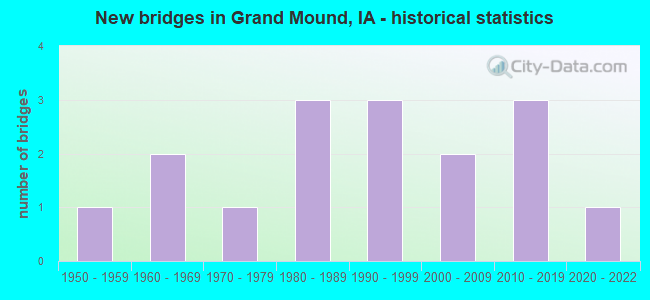
- New bridges - historical statistics
- 11950-1959
- 21960-1969
- 11970-1979
- 31980-1989
- 31990-1999
- 22000-2009
- 32010-2019
- 12020-2022
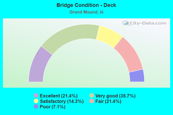
- Bridge Condition - Deck
- 21.4%Excellent
- 35.7%Very good
- 14.3%Satisfactory
- 21.4%Fair
- 7.1%Poor
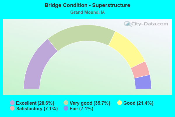
- Bridge Condition - Superstructure
- 28.6%Excellent
- 35.7%Very good
- 21.4%Good
- 7.1%Satisfactory
- 7.1%Fair
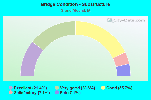
- Bridge Condition - Substructure
- 21.4%Excellent
- 28.6%Very good
- 35.7%Good
- 7.1%Satisfactory
- 7.1%Fair
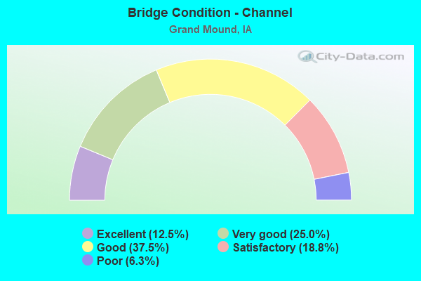
- Bridge Condition - Channel
- 12.5%Excellent
- 25.0%Very good
- 37.5%Good
- 18.8%Satisfactory
- 6.3%Poor
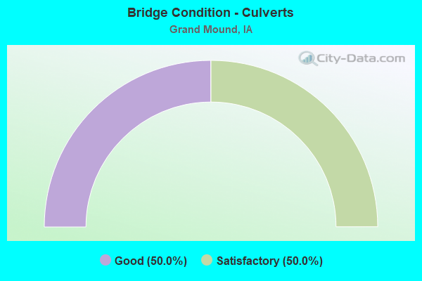
- Bridge Condition - Culverts
- 50.0%Good
- 50.0%Satisfactory
Find on map >> Show street view
Structure Number: 20781, Location: 1.5 MI. E OF SR Y54 (Lat: 41.825644, Lng: -90.618386), Route carried "on" structure: US 30, Year Built: 1976, Status: Open, Structure Length: 1.31m (4.30ft), Average Daily Traffic: 4,450 (year 2020), Truck Traffic: 14%, Average Future Daily Traffic: 4,450 (year 2040), Design Load: HS 20, Features Intersected: PASCALS CREEK
Minimum Vertical Clearance: 30+ m (98+ ft), Kilometerpoint: 492.881, Lanes on structure: 2, Base Highway Network: Yes, Owner: State Highway Agency, Approaching Roadway Width: 13.4m (44.0ft), Skew: 3 degrees, Material/Design: Concrete continuous, Design/Construction: Culvert, Number Of Spans In Main Unit: 3, Length of Maximum Span: 3.7m (12.1ft)
Condition: Channel: Satisfactory, Culverts: Good, Operating Rating: 50.3 metric tons, Method Used To Determine Operating Rating: Load Factor (LF), Inventory Rating: 30.1 metric tons, Method Used To Determine Inventory Rating: Load Factor (LF), Structural Evaluation: Better than present minimum criteria, Waterway Adequacy: Equal to present minimum criteria, Approach Roadway Alignment: Better than present minimum criteria, Designated Inspection Frequency: Every 24 months, Inspection Date: December 2020
Find on map >> Show street view
Structure Number: 12153, Location: 080E20104 (Lat: 41.760950, Lng: -90.682744), Route carried "on" structure: County highway , Year Built: 1965, Status: Open, Structure Length: 3.05m (10.01ft), Average Daily Traffic: 700 (year 2018), Average Future Daily Traffic: 700 (year 2041), Design Load: HS 20, Features Intersected: DRAINAGE DITCH 5, Facility Carried by Structure: 210TH AVENUE
Minimum Vertical Clearance: 30+ m (98+ ft), Kilometerpoint: 0.684, Lanes on structure: 2, Owner: County Highway Agency, Approaching Roadway Width: 10.4m (34.1ft), Skew: 4 degrees, Material/Design: Concrete continuous, Design/Construction: Slab, Number Of Spans In Main Unit: 3, Length of Maximum Span: 11.9m (39.0ft), Curb-To-Curb Width: 8.5m (27.9ft), Out-to-Out Width: 9.1m (29.9ft)
Condition: Deck: Poor, Superstructure: Fair, Substructure: Fair, Channel: Poor, Operating Rating: 50.3 metric tons, Method Used To Determine Operating Rating: Allowable Stress (AS), Inventory Rating: 30.3 metric tons, Method Used To Determine Inventory Rating: Allowable Stress (AS), Structural Evaluation: Somewhat better than minimum adequacy, Deck Geometry: Somewhat better than minimum adequacy, Waterway Adequacy: Equal to present desirable criteria, Approach Roadway Alignment: Better than present minimum criteria, Length Of Structure Improvement: 10.00m (32.81ft), Designated Inspection Frequency: Every 24 months, Inspection Date: Febuary 2021, Bridge Improvement Cost: $130,000, Roadway Improvement Cost: $50,000, Deck Structure Type: Concrete Cast-file-Place, Wearing Surface/Protective System: Wearing Surface: Monolithic Concrete
Find on map >> Show street view
Structure Number: 121551, Location: 080E20205 (Lat: 41.766375, Lng: -90.686339), Route carried "on" structure: County highway , Year Built: 1996, Status: Open, Structure Length: 0.64m (2.10ft), Average Daily Traffic: 170 (year 2014), Truck Traffic: 12%, Average Future Daily Traffic: 170 (year 2042), Design Load: HS 20, Features Intersected: DRAINAGE, Facility Carried by Structure: 278TH ST
Minimum Vertical Clearance: 30+ m (98+ ft), Kilometerpoint: 7.181, Lanes on structure: 2, Owner: County Highway Agency, Approaching Roadway Width: 8.5m (27.9ft), Material/Design: Prestressed concrete, Design/Construction: Stringer/Multi-beam, Number Of Spans In Main Unit: 1, Length of Maximum Span: 6.1m (20.0ft), Curb-To-Curb Width: 8.6m (28.2ft), Out-to-Out Width: 9.2m (30.2ft)
Condition: Deck: Fair, Superstructure: Very good, Substructure: Good, Channel: Satisfactory, Operating Rating: 62.6 metric tons, Method Used To Determine Operating Rating: Load Factor (LF), Inventory Rating: 37.5 metric tons, Method Used To Determine Inventory Rating: Load Factor (LF), Structural Evaluation: Better than present minimum criteria, Deck Geometry: Equal to present minimum criteria, Waterway Adequacy: Equal to present desirable criteria, Approach Roadway Alignment: Equal to present desirable criteria, Designated Inspection Frequency: Every 24 months, Inspection Date: Febuary 2022, Deck Structure Type: Concrete Precast Panels, Wearing Surface/Protective System: Wearing Surface: Monolithic Concrete
Find on map >> Show street view
Structure Number: 121981, Location: 081E22404 (Lat: 41.802564, Lng: -90.674925), Route carried "on" structure: County highway , Year Built: 1992, Status: Open, Structure Length: 1.52m (4.99ft), Average Daily Traffic: 50 (year 2014), Average Future Daily Traffic: 50 (year 2042), Design Load: HS 20, Features Intersected: CREEK, Facility Carried by Structure: 215TH AVE
Minimum Vertical Clearance: 30+ m (98+ ft), Kilometerpoint: 2.676, Lanes on structure: 2, Owner: County Highway Agency, Approaching Roadway Width: 7.9m (25.9ft), Material/Design: Prestressed concrete, Design/Construction: Tee Beam, Number Of Spans In Main Unit: 1, Length of Maximum Span: 14.9m (48.9ft), Curb-To-Curb Width: 5.9m (19.4ft), Out-to-Out Width: 6.1m (20.0ft)
Condition: Deck: Very good, Superstructure: Very good, Substructure: Good, Channel: Good, Operating Rating: 51.5 metric tons, Method Used To Determine Operating Rating: Load Factor (LF), Inventory Rating: 30.8 metric tons, Method Used To Determine Inventory Rating: Load Factor (LF), Structural Evaluation: Better than present minimum criteria, Deck Geometry: Meets minimum limits, Waterway Adequacy: Equal to present desirable criteria, Approach Roadway Alignment: Equal to present desirable criteria, Designated Inspection Frequency: Every 24 months, Inspection Date: January 2022, Deck Structure Type: Concrete Precast Panels, Wearing Surface/Protective System: Wearing Surface: Monolithic Concrete
Find on map >> Show street view
Structure Number: 121993, Location: 081E22601 (Lat: 41.800114, Lng: -90.696781), Route carried "on" structure: County highway , Year Built: 2006, Status: Open, Structure Length: 0.91m (2.99ft), Average Daily Traffic: 10 (year 2014), Average Future Daily Traffic: 10 (year 2041), Design Load: HL 93, Features Intersected: SMALL STREAM, Facility Carried by Structure: 260TH ST
Minimum Vertical Clearance: 30+ m (98+ ft), Kilometerpoint: 5.103, Lanes on structure: 2, Owner: County Highway Agency, Approaching Roadway Width: 6.7m (22.0ft), Skew: 3 degrees, Material/Design: Steel, Design/Construction: Stringer/Multi-beam, Number Of Spans In Main Unit: 1, Length of Maximum Span: 8.8m (28.9ft), Curb-To-Curb Width: 9.1m (29.9ft), Out-to-Out Width: 9.8m (32.2ft)
Condition: Deck: Very good, Superstructure: Very good, Substructure: Very good, Channel: Very good, Operating Rating: 97.2 metric tons, Method Used To Determine Operating Rating: Load and Resistance Factor Rating (LRFR) rating reported by rating factor(RF) method using HL-93 loadings, Inventory Rating: 77.1 metric tons, Method Used To Determine Inventory Rating: Load and Resistance Factor Rating (LRFR) rating reported by rating factor(RF) method using HL-93 loadings, Structural Evaluation: Equal to present desirable criteria, Deck Geometry: Better than present minimum criteria, Waterway Adequacy: Equal to present desirable criteria, Approach Roadway Alignment: Equal to present desirable criteria, Designated Inspection Frequency: Every 48 months, Inspection Date: Febuary 2021, Deck Structure Type: Concrete Cast-file-Place, Wearing Surface/Protective System: Wearing Surface: Monolithic Concrete
Find on map >> Show street view
Structure Number: 12206, Location: 081030802 (Lat: 41.829169, Lng: -90.645792), Route carried "on" structure: City street , Year Built: 1960, Status: Open, Structure Length: 0.82m (2.69ft), Average Daily Traffic: 320 (year 2018), Average Future Daily Traffic: 320 (year 2040), Design Load: H 20, Features Intersected: CREEK, Facility Carried by Structure: N.EAST ST.
Minimum Vertical Clearance: 30+ m (98+ ft), Kilometerpoint: 1.609, Lanes on structure: 2, Owner: City or Municipal Highway Agency, Approaching Roadway Width: 9.1m (29.9ft), Material/Design: Concrete continuous, Design/Construction: Culvert, Number Of Spans In Main Unit: 2, Length of Maximum Span: 3.7m (12.1ft), Curb-To-Curb Width: 9.1m (29.9ft), Out-to-Out Width: 9.1m (29.9ft)
Condition: Channel: Good, Culverts: Satisfactory, Operating Rating: 32.7 metric tons, Method Used To Determine Operating Rating: Field evaluation and documented engineering judgment, Inventory Rating: 24.5 metric tons, Method Used To Determine Inventory Rating: Field evaluation and documented engineering judgment, Structural Evaluation: Equal to present minimum criteria, Deck Geometry: Equal to present minimum criteria, Waterway Adequacy: Better than present minimum criteria, Approach Roadway Alignment: Equal to present desirable criteria, Length Of Structure Improvement: 3.00m (9.84ft), Designated Inspection Frequency: Every 24 months, Inspection Date: May 2020, Bridge Improvement Cost: $15,000, Roadway Improvement Cost: $2,000
Find on map >> Show street view
Structure Number: 122131, Location: 081E31905 (Lat: 41.807406, Lng: -90.646958), Route carried "on" structure: County highway , Year Built: 1991, Status: Open, Structure Length: 0.91m (2.99ft), Average Daily Traffic: 20 (year 2014), Average Future Daily Traffic: 20 (year 2042), Design Load: H 20, Features Intersected: BARBER CREEK, Facility Carried by Structure: 255TH ST
Minimum Vertical Clearance: 30+ m (98+ ft), Kilometerpoint: 3.726, Lanes on structure: 2, Owner: County Highway Agency, Approaching Roadway Width: 7.3m (24.0ft), Material/Design: Steel, Design/Construction: Stringer/Multi-beam, Number Of Spans In Main Unit: 1, Length of Maximum Span: 8.8m (28.9ft), Curb-To-Curb Width: 5.9m (19.4ft), Out-to-Out Width: 6.2m (20.3ft)
Condition: Deck: Fair, Superstructure: Good, Substructure: Good, Channel: Good, Operating Rating: 73.6 metric tons, Method Used To Determine Operating Rating: Allowable Stress (AS), Inventory Rating: 52.8 metric tons, Method Used To Determine Inventory Rating: Allowable Stress (AS), Structural Evaluation: Better than present minimum criteria, Deck Geometry: Meets minimum limits, Waterway Adequacy: Equal to present minimum criteria, Approach Roadway Alignment: Equal to present desirable criteria, Designated Inspection Frequency: Every 24 months, Inspection Date: January 2022, Deck Structure Type: Wood or Timber, Wearing Surface/Protective System: Wearing Surface: Wood or Timber
Find on map >> Show street view
Structure Number: 122181, Location: 081E32902 (Lat: 41.787797, Lng: -90.645919), Route carried "on" structure: County highway , Year Built: 2010, Status: Open, Structure Length: 4.33m (14.21ft), Average Daily Traffic: 440 (year 2018), Truck Traffic: 6%, Average Future Daily Traffic: 440 (year 2041), Design Load: HL 93, Features Intersected: BARBER CREEK, Facility Carried by Structure: 230TH AVENUE
Minimum Vertical Clearance: 30+ m (98+ ft), Kilometerpoint: 0.243, Lanes on structure: 2, Owner: County Highway Agency, Approaching Roadway Width: 9.1m (29.9ft), Material/Design: Concrete continuous, Design/Construction: Slab, Number Of Spans In Main Unit: 3, Length of Maximum Span: 16.8m (55.1ft), Curb-To-Curb Width: 9.1m (29.9ft), Out-to-Out Width: 10.1m (33.1ft)
Condition: Deck: Very good, Superstructure: Excellent, Substructure: Very good, Channel: Excellent, Operating Rating: 54.8 metric tons, Method Used To Determine Operating Rating: Load and Resistance Factor Rating (LRFR) rating reported by rating factor(RF) method using HL-93 loadings, Inventory Rating: 41.8 metric tons, Method Used To Determine Inventory Rating: Load and Resistance Factor Rating (LRFR) rating reported by rating factor(RF) method using HL-93 loadings, Structural Evaluation: Equal to present desirable criteria, Deck Geometry: Equal to present minimum criteria, Waterway Adequacy: Superior to present desirable criteria, Approach Roadway Alignment: Superior to present desirable criteria, Designated Inspection Frequency: Every 48 months, Inspection Date: Febuary 2021, Deck Structure Type: Concrete Cast-file-Place, Wearing Surface/Protective System: Wearing Surface: Monolithic Concrete
Find on map >> Show street view
Structure Number: 122201, Location: 081E33004 (Lat: 41.796208, Lng: -90.660414), Route carried "on" structure: County highway , Year Built: 1983, Status: Open, Structure Length: 1.89m (6.20ft), Average Daily Traffic: 40 (year 2014), Average Future Daily Traffic: 40 (year 2042), Design Load: H 20, Features Intersected: SMALL, Facility Carried by Structure: 233TH AVE
Minimum Vertical Clearance: 30+ m (98+ ft), Kilometerpoint: 1.176, Lanes on structure: 2, Owner: County Highway Agency, Approaching Roadway Width: 6.7m (22.0ft), Material/Design: Steel, Design/Construction: Stringer/Multi-beam, Number Of Spans In Main Unit: 1, Length of Maximum Span: 18.3m (60.0ft), Curb-To-Curb Width: 5.5m (18.0ft), Out-to-Out Width: 6.1m (20.0ft)
Condition: Deck: Fair, Superstructure: Good, Substructure: Good, Channel: Good, Operating Rating: 42.4 metric tons, Method Used To Determine Operating Rating: Load Factor (LF), Inventory Rating: 25.5 metric tons, Method Used To Determine Inventory Rating: Load Factor (LF), Structural Evaluation: Equal to present minimum criteria, Deck Geometry: Meets minimum limits, Waterway Adequacy: Equal to present desirable criteria, Approach Roadway Alignment: Equal to present desirable criteria, Designated Inspection Frequency: Every 24 months, Inspection Date: January 2022, Deck Structure Type: Wood or Timber, Wearing Surface/Protective System: Wearing Surface: Wood or Timber
Find on map >> Show street view
Structure Number: 12221, Location: 081E33203 (Lat: 41.785675, Lng: -90.629514), Route carried "on" structure: County highway , Year Built: 1950, Status: Posted for load, Structure Length: 3.81m (12.50ft), Average Daily Traffic: 100 (year 2018), Average Future Daily Traffic: 100 (year 2042), Design Load: H 20, Features Intersected: BARBER CREEK, Facility Carried by Structure: 270TH ST
Minimum Vertical Clearance: 30+ m (98+ ft), Kilometerpoint: 10.556, Lanes on structure: 2, Owner: County Highway Agency, Approaching Roadway Width: 7.9m (25.9ft), Skew: 3 degrees, Material/Design: Steel continuous, Design/Construction: Stringer/Multi-beam, Number Of Spans In Main Unit: 3, Length of Maximum Span: 14.3m (46.9ft), Curb-To-Curb Width: 6.1m (20.0ft), Out-to-Out Width: 6.7m (22.0ft)
Condition: Deck: Satisfactory, Superstructure: Good, Substructure: Good, Channel: Good, Operating Rating: 26.8 metric tons, Method Used To Determine Operating Rating: Allowable Stress (AS), Inventory Rating: 18.0 metric tons, Method Used To Determine Inventory Rating: Allowable Stress (AS), Structural Evaluation: Somewhat better than minimum adequacy, Deck Geometry: Somewhat better than minimum adequacy, Waterway Adequacy: Equal to present desirable criteria, Approach Roadway Alignment: Equal to present desirable criteria, Bridge Posting: Required (Relationship of Operating Rating to Maximum Legal Load: 10.0 - 19.9% below), Designated Inspection Frequency: Every 24 months, Inspection Date: January 2022, Deck Structure Type: Concrete Cast-file-Place, Wearing Surface/Protective System: Wearing Surface: Monolithic Concrete
Find on map >> Show street view
Structure Number: 122222, Location: 081E33305 (Lat: 41.776300, Lng: -90.623094), Route carried "on" structure: County highway , Year Built: 2017, Status: Open, Structure Length: 3.15m (10.33ft), Average Daily Traffic: 40 (year 2014), Average Future Daily Traffic: 40 (year 2042), Design Load: HS 20, Features Intersected: BARBER CREEK, Facility Carried by Structure: 278TH ST
Minimum Vertical Clearance: 30+ m (98+ ft), Kilometerpoint: 12.598, Lanes on structure: 2, Owner: County Highway Agency, Approaching Roadway Width: 7.9m (25.9ft), Material/Design: Prestressed concrete, Design/Construction: Tee Beam, Number Of Spans In Main Unit: 2, Length of Maximum Span: 15.7m (51.5ft), Curb-To-Curb Width: 8.4m (27.6ft), Out-to-Out Width: 8.5m (27.9ft)
Condition: Deck: Excellent, Superstructure: Excellent, Substructure: Excellent, Channel: Very good, Operating Rating: 53.5 metric tons, Method Used To Determine Operating Rating: Load Factor (LF), Inventory Rating: 32.1 metric tons, Method Used To Determine Inventory Rating: Load Factor (LF), Structural Evaluation: Better than present minimum criteria, Deck Geometry: Equal to present minimum criteria, Waterway Adequacy: Equal to present desirable criteria, Approach Roadway Alignment: Equal to present desirable criteria, Designated Inspection Frequency: Every 24 months, Inspection Date: January 2022, Deck Structure Type: Concrete Precast Panels, Wearing Surface/Protective System: Wearing Surface: Monolithic Concrete
Find on map >> Show street view
Structure Number: 122241, Location: 081E33306 (Lat: 41.775742, Lng: -90.612533), Route carried "on" structure: County highway , Year Built: 1985, Status: Open, Structure Length: 1.86m (6.10ft), Average Daily Traffic: 40 (year 2014), Average Future Daily Traffic: 40 (year 2042), Design Load: H 20, Features Intersected: BARBER CREEK, Facility Carried by Structure: 247TH AVE
Minimum Vertical Clearance: 30+ m (98+ ft), Kilometerpoint: 1.601, Lanes on structure: 2, Owner: County Highway Agency, Approaching Roadway Width: 6.7m (22.0ft), Material/Design: Steel, Design/Construction: Stringer/Multi-beam, Number Of Spans In Main Unit: 1, Length of Maximum Span: 18.3m (60.0ft), Curb-To-Curb Width: 5.5m (18.0ft), Out-to-Out Width: 6.1m (20.0ft)
Condition: Deck: Satisfactory, Superstructure: Satisfactory, Substructure: Satisfactory, Channel: Satisfactory, Operating Rating: 47.9 metric tons, Method Used To Determine Operating Rating: Allowable Stress (AS), Inventory Rating: 35.8 metric tons, Method Used To Determine Inventory Rating: Allowable Stress (AS), Structural Evaluation: Equal to present minimum criteria, Deck Geometry: Meets minimum limits, Waterway Adequacy: Better than present minimum criteria, Approach Roadway Alignment: Better than present minimum criteria, Designated Inspection Frequency: Every 24 months, Inspection Date: January 2022, Deck Structure Type: Wood or Timber, Wearing Surface/Protective System: Wearing Surface: Wood or Timber
Find on map >> Show street view
Structure Number: 123611, Location: 082E32902 (Lat: 41.881106, Lng: -90.645628), Route carried "on" structure: County highway , Year Built: 2013, Status: Open, Structure Length: 2.53m (8.30ft), Average Daily Traffic: 320 (year 2018), Truck Traffic: 13%, Average Future Daily Traffic: 320 (year 2040), Design Load: HS 20, Features Intersected: SMALL CREEK, Facility Carried by Structure: Y54 (230TH AVE)
Minimum Vertical Clearance: 30+ m (98+ ft), Kilometerpoint: 8.591, Lanes on structure: 2, Owner: County Highway Agency, Approaching Roadway Width: 9.8m (32.2ft), Material/Design: Concrete continuous, Design/Construction: Slab, Number Of Spans In Main Unit: 3, Length of Maximum Span: 9.4m (30.8ft), Curb-To-Curb Width: 9.1m (29.9ft), Out-to-Out Width: 10.2m (33.5ft)
Condition: Deck: Excellent, Superstructure: Excellent, Substructure: Excellent, Channel: Excellent, Operating Rating: 68.0 metric tons, Method Used To Determine Operating Rating: Load Factor (LF), Inventory Rating: 40.8 metric tons, Method Used To Determine Inventory Rating: Load Factor (LF), Structural Evaluation: Superior to present desirable criteria, Deck Geometry: Equal to present minimum criteria, Waterway Adequacy: Superior to present desirable criteria, Approach Roadway Alignment: Equal to present desirable criteria, Designated Inspection Frequency: Every 48 months, Inspection Date: January 2020, Deck Structure Type: Concrete Cast-file-Place, Wearing Surface/Protective System: Wearing Surface: Monolithic Concrete, Deck Protection: Epoxy Coated Reinforcing
Find on map >> Show street view
Structure Number: 123621, Location: 082E32902 (Lat: 41.875558, Lng: -90.645564), Route carried "on" structure: County highway , Year Built: 1987, Status: Open, Structure Length: 2.38m (7.81ft), Average Daily Traffic: 320 (year 2018), Truck Traffic: 13%, Average Future Daily Traffic: 320 (year 2040), Design Load: HS 20, Features Intersected: NEGRO CREEK, Facility Carried by Structure: 230TH AVE
Minimum Vertical Clearance: 30+ m (98+ ft), Kilometerpoint: 7.974, Lanes on structure: 2, Owner: County Highway Agency, Approaching Roadway Width: 9.8m (32.2ft), Skew: 3 degrees, Material/Design: Concrete continuous, Design/Construction: Slab, Number Of Spans In Main Unit: 3, Length of Maximum Span: 8.5m (27.9ft), Curb-To-Curb Width: 9.1m (29.9ft), Out-to-Out Width: 9.8m (32.2ft)
Condition: Deck: Very good, Superstructure: Very good, Substructure: Very good, Channel: Good, Operating Rating: 59.4 metric tons, Method Used To Determine Operating Rating: Allowable Stress (AS), Inventory Rating: 39.0 metric tons, Method Used To Determine Inventory Rating: Allowable Stress (AS), Structural Evaluation: Equal to present desirable criteria, Deck Geometry: Equal to present minimum criteria, Waterway Adequacy: Superior to present desirable criteria, Approach Roadway Alignment: Equal to present desirable criteria, Designated Inspection Frequency: Every 48 months, Inspection Date: January 2020, Deck Structure Type: Concrete Cast-file-Place, Wearing Surface/Protective System: Wearing Surface: Monolithic Concrete
Find on map >> Show street view
Structure Number: 123631, Location: 082E33002 (Lat: 41.874789, Lng: -90.665086), Route carried "on" structure: County highway , Year Built: 2020, Status: Open, Structure Length: 1.04m (3.41ft), Average Daily Traffic: 60 (year 2014), Average Future Daily Traffic: 60 (year 2041), Design Load: HL 93, Features Intersected: CREEK, Facility Carried by Structure: 220TH AVE
Minimum Vertical Clearance: 30+ m (98+ ft), Kilometerpoint: 5.811, Lanes on structure: 2, Owner: County Highway Agency, Approaching Roadway Width: 8.5m (27.9ft), Material/Design: Steel, Design/Construction: Stringer/Multi-beam, Number Of Spans In Main Unit: 1, Length of Maximum Span: 9.6m (31.5ft), Curb-To-Curb Width: 9.3m (30.5ft), Out-to-Out Width: 9.4m (30.8ft)
Condition: Deck: Excellent, Superstructure: Excellent, Substructure: Excellent, Channel: Very good, Operating Rating: 93.3 metric tons, Method Used To Determine Operating Rating: Load and Resistance Factor Rating (LRFR) rating reported by rating factor(RF) method using HL-93 loadings, Inventory Rating: 71.9 metric tons, Method Used To Determine Inventory Rating: Load and Resistance Factor Rating (LRFR) rating reported by rating factor(RF) method using HL-93 loadings, Structural Evaluation: Superior to present desirable criteria, Deck Geometry: Better than present minimum criteria, Waterway Adequacy: Equal to present desirable criteria, Approach Roadway Alignment: Equal to present desirable criteria, Designated Inspection Frequency: Every 24 months, Inspection Date: January 2021, Deck Structure Type: Concrete Cast-file-Place, Wearing Surface/Protective System: Wearing Surface: Monolithic Concrete
Find on map >> Show street view
Structure Number: 36544, Location: 081E31708 (Lat: 41.826436, Lng: -90.631278), Route carried "on" structure: County highway , Year Built: 2009, Status: Open, Structure Length: 1.01m (3.31ft), Average Daily Traffic: 20 (year 2014), Average Future Daily Traffic: 20 (year 2041), Design Load: HS 20, Features Intersected: CREEK, Facility Carried by Structure: 237TH AVE
Minimum Vertical Clearance: 30+ m (98+ ft), Kilometerpoint: 2.667, Lanes on structure: 2, Owner: County Highway Agency, Approaching Roadway Width: 7.9m (25.9ft), Material/Design: Steel, Design/Construction: Stringer/Multi-beam, Number Of Spans In Main Unit: 1, Length of Maximum Span: 9.8m (32.2ft), Curb-To-Curb Width: 9.4m (30.8ft), Out-to-Out Width: 9.8m (32.2ft)
Condition: Deck: Very good, Superstructure: Very good, Substructure: Very good, Channel: Very good, Operating Rating: 74.1 metric tons, Method Used To Determine Operating Rating: Load Factor (LF), Inventory Rating: 40.8 metric tons, Method Used To Determine Inventory Rating: Load Factor (LF), Structural Evaluation: Equal to present desirable criteria, Deck Geometry: Better than present minimum criteria, Waterway Adequacy: Superior to present desirable criteria, Approach Roadway Alignment: Superior to present desirable criteria, Designated Inspection Frequency: Every 48 months, Inspection Date: Febuary 2021, Deck Structure Type: Concrete Cast-file-Place, Wearing Surface/Protective System: Wearing Surface: Monolithic Concrete