Bridge Statistics for Greendale, Indiana (IN)
Condition, Traffic, Stress, Structural Evaluation, Project Costs
- National Bridge Inventory (NBI) Statistics
- 12Number of bridges
- 112ft / 33.6mTotal length
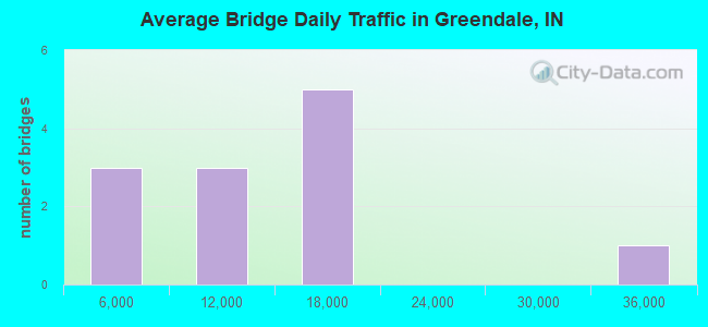
- 124,578Total average daily traffic
- 15,518Total average daily truck traffic
- National Bridge Inventory (NBI) Registered Bridges for Greendale
- No street view available for this location
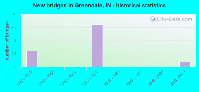
- New bridges - historical statistics
- 31940-1949
- 81970-1979
- 12010-2019
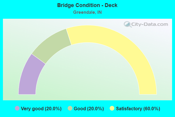
- Bridge Condition - Deck
- 20.0%Very good
- 20.0%Good
- 60.0%Satisfactory
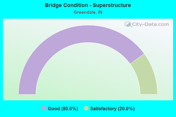
- Bridge Condition - Superstructure
- 80.0%Good
- 20.0%Satisfactory
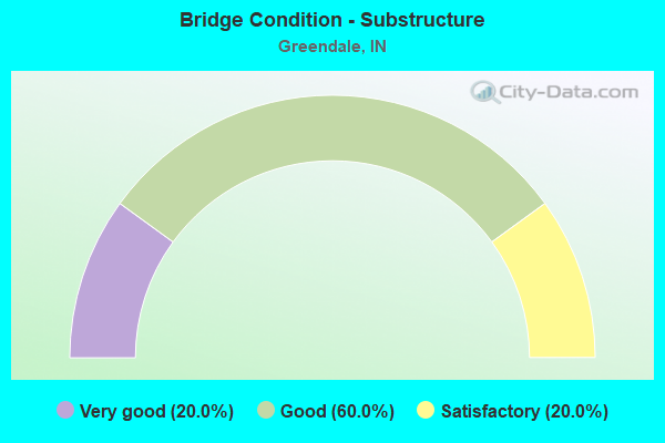
- Bridge Condition - Substructure
- 20.0%Very good
- 60.0%Good
- 20.0%Satisfactory
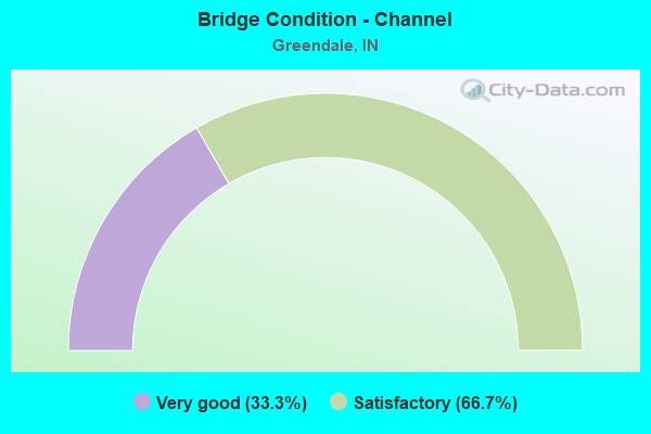
- Bridge Condition - Channel
- 33.3%Very good
- 66.7%Satisfactory
Find on map >> Show street view
Structure Number: 1884, Location: 02.13 E SR 1 (Lat: 39.148450, Lng: -84.823389), Route carried "on" structure: US 50, Year Built: 1940, Status: Open, Structure Length: 1.28m (4.20ft), Average Daily Traffic: 12,379 (year 2004), Truck Traffic: 10%, Average Future Daily Traffic: 17,350 (year 2030), Design Load: H 20, Features Intersected: DOUBLE LICK CREEK
Minimum Vertical Clearance: 30+ m (98+ ft), Kilometerpoint: 34.166, Lanes on structure: 4, Base Highway Network: Yes (, Subroute: 1), Owner: State Highway Agency, Approaching Roadway Width: 15.2m (49.9ft), Skew: 2 degrees, Material/Design: Concrete, Design/Construction: Culvert, Number Of Spans In Main Unit: 1, Length of Maximum Span: 12.2m (40.0ft), Curb-To-Curb Width: 18.0m (59.1ft), Out-to-Out Width: 18.0m (59.1ft)
Condition: Channel: Satisfactory, Culverts: Satisfactory, Operating Rating: 89.8 metric tons, Method Used To Determine Operating Rating: Load Factor (LF), Inventory Rating: 89.8 metric tons, Method Used To Determine Inventory Rating: Load Factor (LF), Structural Evaluation: Equal to present minimum criteria, Deck Geometry: Somewhat better than minimum adequacy, Waterway Adequacy: Better than present minimum criteria, Approach Roadway Alignment: Equal to present desirable criteria, Designated Inspection Frequency: Every 24 months, Inspection Date: August 2021
Find on map >> Show street view
Structure Number: 49675, Location: 01.27 N KY LN (Lat: 39.122119, Lng: -84.833619), Route carried "on" structure: Ramp US , Year Built: 1975, Year Reconstructed: 2015, Status: Open, Structure Length: 6.64m (21.78ft), Average Daily Traffic: 31,874 (year 2004), Truck Traffic: 10%, Average Future Daily Traffic: 46,397 (year 2031), Design Load: HS 20, Features Intersected: I-275, Facility Carried by Structure: US 50 CONNECTOR
Minimum Vertical Clearance: 30+ m (98+ ft), Kilometerpoint: 1.175, Lanes on structure: 2, Lanes under structure: 5, Base Highway Network: Yes (, Subroute: 1), Owner: State Highway Agency, Approaching Roadway Width: 20.7m (67.9ft), Skew: 39 degrees, Material/Design: Steel continuous, Design/Construction: Stringer/Multi-beam, Number Of Spans In Main Unit: 2, Length of Maximum Span: 34.0m (111.5ft), Curb-To-Curb Width: 20.8m (68.2ft), Out-to-Out Width: 21.8m (71.5ft)
Condition: Deck: Satisfactory, Superstructure: Satisfactory, Substructure: Good, Operating Rating: 49.6 metric tons, Method Used To Determine Operating Rating: Load and Resistance Factor Rating (LRFR) rating reported by rating factor(RF) method using HL-93 loadings, Inventory Rating: 38.2 metric tons, Method Used To Determine Inventory Rating: Load and Resistance Factor Rating (LRFR) rating reported by rating factor(RF) method using HL-93 loadings, Structural Evaluation: Equal to present minimum criteria, Deck Geometry: Superior to present desirable criteria, Underclear: Somewhat better than minimum adequacy, Approach Roadway Alignment: Equal to present desirable criteria, Designated Inspection Frequency: Every 24 months, Inspection Date: January 2021, Deck Structure Type: Concrete Cast-file-Place, Wearing Surface/Protective System: Wearing Surface: Latex Concrete
Find on map >> Show street view
Structure Number: 4968, Location: 01.34 N US 50 (Lat: 39.139950, Lng: -84.827261), Route carried "on" structure: Interstate 275, Year Built: 1974, Year Reconstructed: 2019, Status: Open, Structure Length: 4.59m (15.06ft), Average Daily Traffic: 16,110 (year 2018), Truck Traffic: 19%, Average Future Daily Traffic: 18,480 (year 2038), Design Load: HL 93, Features Intersected: AUCTION LANE
Minimum Vertical Clearance: 30+ m (98+ ft), Kilometerpoint: 4.200, Lanes on structure: 2, Lanes under structure: 2, Base Highway Network: Yes (, Subroute: 1), Owner: State Highway Agency, Approaching Roadway Width: 12.1m (39.7ft), Skew: 4 degrees, Material/Design: Steel continuous, Design/Construction: Stringer/Multi-beam, Number Of Spans In Main Unit: 3, Length of Maximum Span: 17.1m (56.1ft), Curb-To-Curb Width: 12.1m (39.7ft), Out-to-Out Width: 13.0m (42.7ft)
Condition: Deck: Satisfactory, Superstructure: Good, Substructure: Good, Operating Rating: 53.8 metric tons, Method Used To Determine Operating Rating: Load and Resistance Factor Rating (LRFR) rating reported by rating factor(RF) method using HL-93 loadings, Inventory Rating: 41.5 metric tons, Method Used To Determine Inventory Rating: Load and Resistance Factor Rating (LRFR) rating reported by rating factor(RF) method using HL-93 loadings, Structural Evaluation: Better than present minimum criteria, Deck Geometry: Equal to present minimum criteria, Underclear: High priority of corrective action, Approach Roadway Alignment: Equal to present desirable criteria, Designated Inspection Frequency: Every 24 months, Inspection Date: January 2021, Deck Structure Type: Concrete Cast-file-Place, Wearing Surface/Protective System: Wearing Surface: Latex Concrete
Find on map >> Show street view
Structure Number: 4969, Location: 01.34 N US 50 (Lat: 39.140281, Lng: -84.827250), Route carried "on" structure: Interstate 275, Year Built: 1974, Year Reconstructed: 2019, Status: Open, Structure Length: 4.59m (15.06ft), Average Daily Traffic: 16,140 (year 2018), Truck Traffic: 20%, Average Future Daily Traffic: 18,520 (year 2038), Design Load: HL 93, Features Intersected: AUCTION LANE
Minimum Vertical Clearance: 30+ m (98+ ft), Kilometerpoint: 4.200, Lanes on structure: 2, Lanes under structure: 2, Base Highway Network: Yes (, Subroute: 1), Owner: State Highway Agency, Approaching Roadway Width: 12.1m (39.7ft), Skew: 4 degrees, Material/Design: Steel continuous, Design/Construction: Stringer/Multi-beam, Number Of Spans In Main Unit: 3, Length of Maximum Span: 17.1m (56.1ft), Curb-To-Curb Width: 12.1m (39.7ft), Out-to-Out Width: 13.0m (42.7ft)
Condition: Deck: Satisfactory, Superstructure: Good, Substructure: Good, Operating Rating: 53.8 metric tons, Method Used To Determine Operating Rating: Load and Resistance Factor Rating (LRFR) rating reported by rating factor(RF) method using HL-93 loadings, Inventory Rating: 41.5 metric tons, Method Used To Determine Inventory Rating: Load and Resistance Factor Rating (LRFR) rating reported by rating factor(RF) method using HL-93 loadings, Structural Evaluation: Better than present minimum criteria, Deck Geometry: Equal to present minimum criteria, Underclear: High priority of corrective action, Approach Roadway Alignment: Equal to present desirable criteria, Designated Inspection Frequency: Every 24 months, Inspection Date: January 2021, Deck Structure Type: Concrete Cast-file-Place, Wearing Surface/Protective System: Wearing Surface: Latex Concrete
Find on map >> Show street view
Structure Number: 80038, Location: 03.35 N US 50 (Lat: 39.154569, Lng: -84.877831), Route carried "on" structure: State highway 1, Year Built: 2012, Status: Open, Structure Length: 6.65m (21.82ft), Average Daily Traffic: 6,229 (year 2018), Truck Traffic: 10%, Average Future Daily Traffic: 7,600 (year 2038), Design Load: HL 93, Features Intersected: SALT FORK
Minimum Vertical Clearance: 30+ m (98+ ft), Kilometerpoint: 5.391, Lanes on structure: 3, Owner: State Highway Agency, Approaching Roadway Width: 15.8m (51.8ft), Skew: 2 degrees, Material/Design: Concrete continuous, Design/Construction: Tee Beam, Number Of Spans In Main Unit: 3, Length of Maximum Span: 23.2m (76.1ft), Curb-To-Curb Width: 15.8m (51.8ft), Out-to-Out Width: 16.7m (54.8ft)
Condition: Deck: Very good, Superstructure: Good, Substructure: Very good, Channel: Very good, Operating Rating: 57.7 metric tons, Method Used To Determine Operating Rating: Load and Resistance Factor Rating (LRFR) rating reported by rating factor(RF) method using HL-93 loadings, Inventory Rating: 44.7 metric tons, Method Used To Determine Inventory Rating: Load and Resistance Factor Rating (LRFR) rating reported by rating factor(RF) method using HL-93 loadings, Structural Evaluation: Better than present minimum criteria, Deck Geometry: Better than present minimum criteria, Waterway Adequacy: Superior to present desirable criteria, Approach Roadway Alignment: Equal to present desirable criteria, Designated Inspection Frequency: Every 24 months, Inspection Date: July 2021, Deck Structure Type: Concrete Cast-file-Place, Wearing Surface/Protective System: Wearing Surface: Epoxy Overlay, Deck Protection: Epoxy Coated Reinforcing
Find on map >> Show street view
Structure Number: 1500093, Location: 00.30 SW OF SR 1 (Lat: 39.154139, Lng: -84.896300), Route carried "on" structure: County highway , Year Built: 1979, Status: Open, Structure Length: 9.85m (32.32ft), Average Daily Traffic: 400 (year 2017), Truck Traffic: 10%, Average Future Daily Traffic: 590 (year 2037), Design Load: HS 20, Features Intersected: TANNERS CREEK, Facility Carried by Structure: PRIBBLE RD
Minimum Vertical Clearance: 30+ m (98+ ft), Kilometerpoint: 0.000, Lanes on structure: 2, Owner: County Highway Agency, Approaching Roadway Width: 6.4m (21.0ft), Skew: 1 degrees, Material/Design: Prestressed concrete continuous, Design/Construction: Stringer/Multi-beam, Number Of Spans In Main Unit: 4, Length of Maximum Span: 25.9m (85.0ft), Curb-To-Curb Width: 7.3m (24.0ft), Out-to-Out Width: 8.1m (26.6ft)
Condition: Deck: Good, Superstructure: Good, Substructure: Satisfactory, Channel: Satisfactory, Operating Rating: 58.7 metric tons, Method Used To Determine Operating Rating: Load Factor (LF), Inventory Rating: 35.1 metric tons, Method Used To Determine Inventory Rating: Load Factor (LF), Structural Evaluation: Equal to present minimum criteria, Deck Geometry: Somewhat better than minimum adequacy, Waterway Adequacy: Equal to present desirable criteria, Approach Roadway Alignment: Equal to present minimum criteria, Designated Inspection Frequency: Every 24 months, Inspection Date: April 2021, Deck Structure Type: Concrete Cast-file-Place, Wearing Surface/Protective System: Wearing Surface: Monolithic Concrete
Find on map >> Show street view
Structure Number: 1883, Location: 01.73 E SR 1 (Lat: 39.143731, Lng: -84.827439), Route carried "under" structure: US 50, Year Built: 1941, Structure Length: 0. m, Average Daily Traffic: 6,190 (year 2004), Truck Traffic: 10%, Features Intersected: US 50 EBL, Facility Carried by Structure: CENTRAL IN RR
Minimum Vertical Clearance: 4.27m (14.01ft), Kilometerpoint: 33.523, Lanes under structure: 2, Material/Design: Steel, Design/Construction: Stringer/Multi-beam, Length of Maximum Span: 18.6m (61.0ft)
Find on map >> Show street view
Structure Number: 1883, Location: 01.73 E SR 1 (Lat: 39.143731, Lng: -84.827439), Route carried "under" structure: US 50, Year Built: 1941, Structure Length: 0. m, Average Daily Traffic: 6,190 (year 2004), Truck Traffic: 10%, Features Intersected: US 50 WBL, Facility Carried by Structure: CENTRAL IN RR
Minimum Vertical Clearance: 4.40m (14.44ft), Kilometerpoint: 33.523, Lanes under structure: 2, Material/Design: Steel, Design/Construction: Stringer/Multi-beam, Length of Maximum Span: 18.6m (61.0ft)
Find on map >> Show street view
Structure Number: 49675, Location: 01.27 N KY LN (Lat: 39.122119, Lng: -84.833625), Route carried "under" structure: Interstate 275, Year Built: 1975, Structure Length: 0. m, Average Daily Traffic: 14,401 (year 2004), Truck Traffic: 10%, Features Intersected: US 50 CONNECTOR
Minimum Vertical Clearance: 4.95m (16.24ft), Kilometerpoint: 2.044, Lanes on structure: 2, Lanes under structure: 5, Material/Design: Steel continuous, Design/Construction: Stringer/Multi-beam, Length of Maximum Span: 34.0m (111.5ft)
Find on map >> Show street view
Structure Number: 4968, Location: 01.34 N US 50 (Lat: 39.139950, Lng: -84.827264), Route carried "under" structure: City street , Year Built: 1974, Structure Length: 0. m, Average Daily Traffic: 132 (year 2004), Truck Traffic: 10%, Features Intersected: AUCTION LANE, Facility Carried by Structure: I-275 NB
Minimum Vertical Clearance: 4.62m (15.16ft), Kilometerpoint: 0.000, Lanes on structure: 2, Lanes under structure: 2, Material/Design: Steel continuous, Design/Construction: Stringer/Multi-beam, Length of Maximum Span: 17.1m (56.1ft)
Find on map >> Show street view
Structure Number: 4969, Location: 01.34 N US 50 (Lat: 39.140281, Lng: -84.827256), Route carried "under" structure: ServiceOther road , Year Built: 1974, Structure Length: 0. m, Average Daily Traffic: 132 (year 2004), Truck Traffic: 10%, Features Intersected: AUCTION LANE, Facility Carried by Structure: I-275 SB
Minimum Vertical Clearance: 4.85m (15.91ft), Kilometerpoint: 0.000, Lanes on structure: 2, Lanes under structure: 2, Material/Design: Steel continuous, Design/Construction: Stringer/Multi-beam, Length of Maximum Span: 17.1m (56.1ft)