Bridge Statistics for Hamburg, Iowa (IA)
Condition, Traffic, Stress, Structural Evaluation, Project Costs
- National Bridge Inventory (NBI) Statistics
- 11Number of bridges
- 197ft / 60.0mTotal length
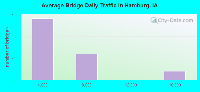
- 34,525Total average daily traffic
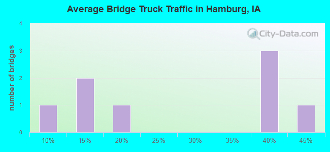
- 12,395Total average daily truck traffic
- National Bridge Inventory (NBI) Registered Bridges for Hamburg
- No street view available for this location
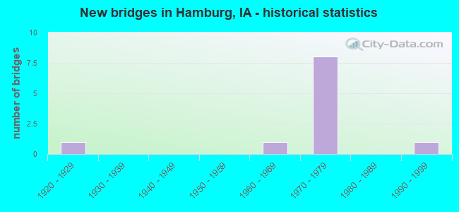
- New bridges - historical statistics
- 11920-1929
- 11960-1969
- 81970-1979
- 11990-1999
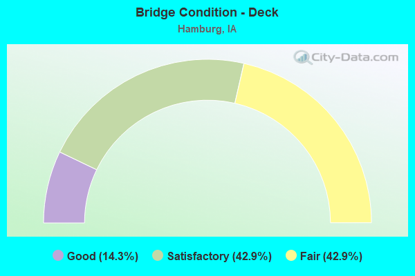
- Bridge Condition - Deck
- 14.3%Good
- 42.9%Satisfactory
- 42.9%Fair
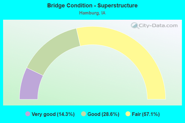
- Bridge Condition - Superstructure
- 14.3%Very good
- 28.6%Good
- 57.1%Fair
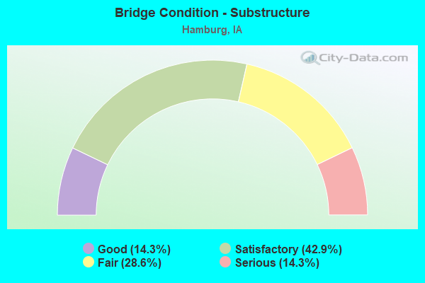
- Bridge Condition - Substructure
- 14.3%Good
- 42.9%Satisfactory
- 28.6%Fair
- 14.3%Serious
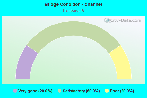
- Bridge Condition - Channel
- 20.0%Very good
- 60.0%Satisfactory
- 20.0%Poor
Find on map >> Show street view
Structure Number: 25251, Location: 0.5 mi W of E JCT. IA 333 (Lat: 40.601364, Lng: -95.644722), Route carried "on" structure: US 275, Year Built: 1994, Status: Open, Structure Length: 19.17m (62.89ft), Average Daily Traffic: 1,050 (year 2020), Truck Traffic: 10%, Average Future Daily Traffic: 1,050 (year 2040), Design Load: HS 20, Features Intersected: NISHNABOTNA RIVER
Minimum Vertical Clearance: 30+ m (98+ ft), Kilometerpoint: 2.503, Lanes on structure: 2, Owner: State Highway Agency, Approaching Roadway Width: 11.3m (37.1ft), Skew: 4 degrees, Material/Design: Prestressed concrete, Design/Construction: Stringer/Multi-beam, Number Of Spans In Main Unit: 6, Length of Maximum Span: 32.6m (107.0ft), Curb-To-Curb Width: 11.0m (36.1ft), Out-to-Out Width: 11.9m (39.0ft)
Condition: Deck: Good, Superstructure: Very good, Substructure: Good, Channel: Satisfactory, Operating Rating: 68.0 metric tons, Method Used To Determine Operating Rating: Load Factor (LF), Inventory Rating: 32.1 metric tons, Method Used To Determine Inventory Rating: Load Factor (LF), Structural Evaluation: Better than present minimum criteria, Deck Geometry: Equal to present minimum criteria, Waterway Adequacy: Equal to present desirable criteria, Approach Roadway Alignment: Equal to present desirable criteria, Designated Inspection Frequency: Every 24 months, Inspection Date: June 2020, Deck Structure Type: Concrete Cast-file-Place, Wearing Surface/Protective System: Wearing Surface: Monolithic Concrete, Deck Protection: Epoxy Coated Reinforcing
Find on map >> Show street view
Structure Number: 25261, Location: 0.9 N of N jct. IA 333 (Lat: 40.615947, Lng: -95.651008), Route carried "on" structure: US 275, Year Built: 1928, Year Reconstructed: 1978, Status: Open, Structure Length: 0.64m (2.10ft), Average Daily Traffic: 1,710 (year 2020), Truck Traffic: 6%, Average Future Daily Traffic: 1,710 (year 2041), Design Load: HS 20, Features Intersected: STREAM
Minimum Vertical Clearance: 30+ m (98+ ft), Kilometerpoint: 4.817, Lanes on structure: 2, Base Highway Network: Yes, Owner: State Highway Agency, Approaching Roadway Width: 8.8m (28.9ft), Material/Design: Concrete, Design/Construction: Culvert, Number Of Spans In Main Unit: 2, Length of Maximum Span: 3.0m (9.8ft)
Condition: Channel: Satisfactory, Culverts: Good, Operating Rating: 44.0 metric tons, Method Used To Determine Operating Rating: Field evaluation and documented engineering judgment, Inventory Rating: 32.7 metric tons, Method Used To Determine Inventory Rating: Field evaluation and documented engineering judgment, Structural Evaluation: Better than present minimum criteria, Waterway Adequacy: Equal to present minimum criteria, Approach Roadway Alignment: Equal to present minimum criteria, Designated Inspection Frequency: Every 24 months, Inspection Date: January 2021
Find on map >> Show street view
Structure Number: 15904, Location: 067420503 (Lat: 40.651750, Lng: -95.695961), Route carried "on" structure: County highway , Year Built: 1960, Status: Open, Structure Length: 0.98m (3.22ft), Average Daily Traffic: 250 (year 2016), Truck Traffic: 15%, Average Future Daily Traffic: 250 (year 2041), Design Load: H 15, Features Intersected: STREAM, Facility Carried by Structure: BLUFF ROAD
Minimum Vertical Clearance: 30+ m (98+ ft), Kilometerpoint: 5.726, Lanes on structure: 2, Owner: County Highway Agency, Approaching Roadway Width: 9.4m (30.8ft), Material/Design: Prestressed concrete, Design/Construction: Stringer/Multi-beam, Number Of Spans In Main Unit: 1, Length of Maximum Span: 9.1m (29.9ft), Curb-To-Curb Width: 7.3m (24.0ft), Out-to-Out Width: 7.3m (24.0ft)
Condition: Deck: Fair, Superstructure: Good, Substructure: Satisfactory, Channel: Satisfactory, Operating Rating: 43.4 metric tons, Method Used To Determine Operating Rating: Allowable Stress (AS), Inventory Rating: 32.3 metric tons, Method Used To Determine Inventory Rating: Allowable Stress (AS), Structural Evaluation: Equal to present minimum criteria, Deck Geometry: Somewhat better than minimum adequacy, Waterway Adequacy: Equal to present desirable criteria, Approach Roadway Alignment: Equal to present minimum criteria, Designated Inspection Frequency: Every 24 months, Inspection Date: June 2021, Bridge Improvement Cost: $50,000, Roadway Improvement Cost: $1,000, Deck Structure Type: Concrete Cast-file-Place, Wearing Surface/Protective System: Wearing Surface: Monolithic Concrete
Find on map >> Show street view
Structure Number: 159071, Location: 067420703 (Lat: 40.637469, Lng: -95.706517), Route carried "on" structure: County highway , Year Built: 1976, Status: Posted for load, Structure Length: 0.98m (3.22ft), Average Daily Traffic: 25 (year 2012), Average Future Daily Traffic: 25 (year 2041), Features Intersected: #6 DITCH, Facility Carried by Structure: 285 STREET
Minimum Vertical Clearance: 30+ m (98+ ft), Kilometerpoint: 1.521, Lanes on structure: 2, Owner: County Highway Agency, Approaching Roadway Width: 6.7m (22.0ft), Material/Design: Wood or Timber, Design/Construction: Slab, Number Of Spans In Main Unit: 1, Length of Maximum Span: 9.4m (30.8ft), Curb-To-Curb Width: 7.3m (24.0ft), Out-to-Out Width: 7.3m (24.0ft)
Condition: Deck: Fair, Superstructure: Fair, Substructure: Serious, Channel: Poor, Operating Rating: 39.0 metric tons, Method Used To Determine Operating Rating: Allowable Stress (AS), Inventory Rating: 26.6 metric tons, Method Used To Determine Inventory Rating: Allowable Stress (AS), Structural Evaluation: High priority of corrective action, Deck Geometry: Equal to present minimum criteria, Waterway Adequacy: Equal to present desirable criteria, Approach Roadway Alignment: Equal to present desirable criteria, Length Of Structure Improvement: 3.20m (10.50ft), Designated Inspection Frequency: Every 24 months, Inspection Date: June 2021, Bridge Improvement Cost: $114,000, Roadway Improvement Cost: $6,000, Deck Structure Type: Wood or Timber, Wearing Surface/Protective System: Wearing Surface: Gravel
Find on map >> Show street view
Structure Number: 60001, Location: 0.4 MI. N OF MO St. LINE (Lat: 40.587203, Lng: -95.657653), Route carried "on" structure: Interstate 29, Year Built: 1972, Status: Open, Structure Length: 11.31m (37.11ft), Average Daily Traffic: 6,200 (year 2020), Truck Traffic: 39%, Average Future Daily Traffic: 6,200 (year 2041), Design Load: HS 20, Features Intersected: BNSF RR & MAIN ST
Minimum Vertical Clearance: 30+ m (98+ ft), Kilometerpoint: 0.618, Lanes on structure: 2, Lanes under structure: 2, Base Highway Network: Yes, Owner: State Highway Agency, Approaching Roadway Width: 12.2m (40.0ft), Skew: 4 degrees, Material/Design: Steel continuous, Design/Construction: Stringer/Multi-beam, Number Of Spans In Main Unit: 4, Length of Maximum Span: 31.1m (102.0ft), Curb-To-Curb Width: 12.2m (40.0ft), Out-to-Out Width: 13.2m (43.3ft)
Condition: Deck: Satisfactory, Superstructure: Fair, Substructure: Fair, Operating Rating: 50.5 metric tons, Method Used To Determine Operating Rating: Load Factor (LF), Inventory Rating: 30.3 metric tons, Method Used To Determine Inventory Rating: Load Factor (LF), Structural Evaluation: Somewhat better than minimum adequacy, Deck Geometry: Better than present minimum criteria, Underclear: Somewhat better than minimum adequacy, Approach Roadway Alignment: Equal to present desirable criteria, Designated Inspection Frequency: Every 24 months, Inspection Date: July 2021, Deck Structure Type: Concrete Cast-file-Place, Wearing Surface/Protective System: Wearing Surface: Low Slump Concrete
Find on map >> Show street view
Structure Number: 60002, Location: 0.4 MI. N OF MO St. LINE (Lat: 40.587558, Lng: -95.658944), Route carried "on" structure: Interstate 29, Year Built: 1972, Status: Open, Structure Length: 11.31m (37.11ft), Average Daily Traffic: 6,200 (year 2020), Truck Traffic: 39%, Average Future Daily Traffic: 6,200 (year 2041), Design Load: HS 20, Features Intersected: BNSF RR & MAIN ST
Minimum Vertical Clearance: 30+ m (98+ ft), Kilometerpoint: 243.777, Lanes on structure: 2, Lanes under structure: 2, Owner: State Highway Agency, Approaching Roadway Width: 12.2m (40.0ft), Skew: 4 degrees, Material/Design: Steel continuous, Design/Construction: Stringer/Multi-beam, Number Of Spans In Main Unit: 4, Length of Maximum Span: 31.1m (102.0ft), Curb-To-Curb Width: 12.2m (40.0ft), Out-to-Out Width: 13.2m (43.3ft)
Condition: Deck: Satisfactory, Superstructure: Fair, Substructure: Satisfactory, Operating Rating: 48.7 metric tons, Method Used To Determine Operating Rating: Load Factor (LF), Inventory Rating: 29.2 metric tons, Method Used To Determine Inventory Rating: Load Factor (LF), Structural Evaluation: Somewhat better than minimum adequacy, Deck Geometry: Better than present minimum criteria, Underclear: Equal to present minimum criteria, Approach Roadway Alignment: Equal to present desirable criteria, Designated Inspection Frequency: Every 24 months, Inspection Date: July 2021, Deck Structure Type: Concrete Cast-file-Place, Wearing Surface/Protective System: Wearing Surface: Low Slump Concrete
Find on map >> Show street view
Structure Number: 60003, Location: 0.4 MI. S OF JCT. IA 333 (Lat: 40.595247, Lng: -95.672508), Route carried "on" structure: Interstate 29, Year Built: 1972, Status: Open, Structure Length: 5.46m (17.91ft), Average Daily Traffic: 6,200 (year 2020), Truck Traffic: 39%, Average Future Daily Traffic: 6,200 (year 2040), Design Load: HS 20, Features Intersected: MAIN DITCH NO.6
Minimum Vertical Clearance: 30+ m (98+ ft), Kilometerpoint: 2.166, Lanes on structure: 2, Base Highway Network: Yes, Owner: State Highway Agency, Approaching Roadway Width: 12.2m (40.0ft), Skew: 5 degrees, Material/Design: Steel continuous, Design/Construction: Stringer/Multi-beam, Number Of Spans In Main Unit: 3, Length of Maximum Span: 22.6m (74.1ft), Curb-To-Curb Width: 12.2m (40.0ft), Out-to-Out Width: 13.2m (43.3ft)
Condition: Deck: Satisfactory, Superstructure: Fair, Substructure: Fair, Channel: Very good, Operating Rating: 70.7 metric tons, Method Used To Determine Operating Rating: Load Factor (LF), Inventory Rating: 42.4 metric tons, Method Used To Determine Inventory Rating: Load Factor (LF), Structural Evaluation: Somewhat better than minimum adequacy, Deck Geometry: Better than present minimum criteria, Waterway Adequacy: Equal to present minimum criteria, Approach Roadway Alignment: Better than present minimum criteria, Designated Inspection Frequency: Every 24 months, Inspection Date: March 2020, Deck Structure Type: Concrete Cast-file-Place, Wearing Surface/Protective System: Wearing Surface: Low Slump Concrete
Find on map >> Show street view
Structure Number: 60005, Location: AT JCT. OF I-29 (Lat: 40.600692, Lng: -95.678308), Route carried "on" structure: State highway 333, Year Built: 1972, Status: Open, Structure Length: 10.18m (33.40ft), Average Daily Traffic: 750 (year 2020), Truck Traffic: 13%, Average Future Daily Traffic: 750 (year 2041), Design Load: HS 20, Features Intersected: I-29
Minimum Vertical Clearance: 30+ m (98+ ft), Kilometerpoint: 0.153, Lanes on structure: 2, Lanes under structure: 4, Base Highway Network: Yes, Owner: State Highway Agency, Approaching Roadway Width: 13.4m (44.0ft), Skew: 3 degrees, Material/Design: Steel continuous, Design/Construction: Stringer/Multi-beam, Number Of Spans In Main Unit: 4, Length of Maximum Span: 32.9m (107.9ft), Curb-To-Curb Width: 9.8m (32.2ft), Out-to-Out Width: 10.8m (35.4ft)
Condition: Deck: Fair, Superstructure: Good, Substructure: Satisfactory, Operating Rating: 64.0 metric tons, Method Used To Determine Operating Rating: Load Factor (LF), Inventory Rating: 38.4 metric tons, Method Used To Determine Inventory Rating: Load Factor (LF), Structural Evaluation: Equal to present minimum criteria, Deck Geometry: Equal to present minimum criteria, Underclear: Somewhat better than minimum adequacy, Approach Roadway Alignment: Equal to present minimum criteria, Designated Inspection Frequency: Every 24 months, Inspection Date: June 2021, Deck Structure Type: Concrete Cast-file-Place, Wearing Surface/Protective System: Wearing Surface: Low Slump Concrete
Find on map >> Show street view
Structure Number: 60001, Location: 0.4 MI. N OF MO St. LINE (Lat: 40.587203, Lng: -95.657653), Route carried "under" structure: County highway , Year Built: 1972, Structure Length: 0. m, Average Daily Traffic: 70 (year 2016), Features Intersected: BNSF RR & MAIN ST, Facility Carried by Structure: NB I-29
Minimum Vertical Clearance: 30+ m (98+ ft), Kilometerpoint: 0.398, Lanes on structure: 2, Lanes under structure: 2, Material/Design: Steel continuous, Design/Construction: Stringer/Multi-beam, Length of Maximum Span: 31.1m (102.0ft)
Find on map >> Show street view
Structure Number: 60002, Location: 0.4 MI. N OF MO St. LINE (Lat: 40.587558, Lng: -95.658944), Route carried "under" structure: County highway , Year Built: 1972, Structure Length: 0. m, Average Daily Traffic: 70 (year 2016), Features Intersected: BNSF RR & MAIN ST, Facility Carried by Structure: SB I-29
Minimum Vertical Clearance: 30+ m (98+ ft), Kilometerpoint: 0.359, Lanes on structure: 2, Lanes under structure: 2, Material/Design: Steel continuous, Design/Construction: Stringer/Multi-beam, Length of Maximum Span: 31.1m (102.0ft)
Find on map >> Show street view
Structure Number: 60005, Location: AT JCT. OF I-29 (Lat: 40.600692, Lng: -95.678308), Route carried "under" structure: Interstate 29, Year Built: 1972, Structure Length: 0. m, Average Daily Traffic: 12,000 (year 2020), Truck Traffic: 40%, Features Intersected: I-29, Facility Carried by Structure: IA 333
Minimum Vertical Clearance: 30+ m (98+ ft), Kilometerpoint: 2.903, Lanes on structure: 2, Lanes under structure: 4, Material/Design: Steel continuous, Design/Construction: Stringer/Multi-beam, Length of Maximum Span: 32.9m (107.9ft)