Bridge Statistics for Hampton, New Hampshire (NH)
Condition, Traffic, Stress, Structural Evaluation, Project Costs
- National Bridge Inventory (NBI) Statistics
- 29Number of bridges
- 246ft / 75.2mTotal length
- $59,698,000Total costs
- 689,375Total average daily traffic
- 52,169Total average daily truck traffic
- National Bridge Inventory (NBI) Registered Bridges for Hampton
- No street view available for this location
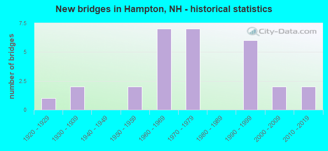
- New bridges - historical statistics
- 11920-1929
- 21930-1939
- 21950-1959
- 71960-1969
- 71970-1979
- 61990-1999
- 22000-2009
- 22010-2019
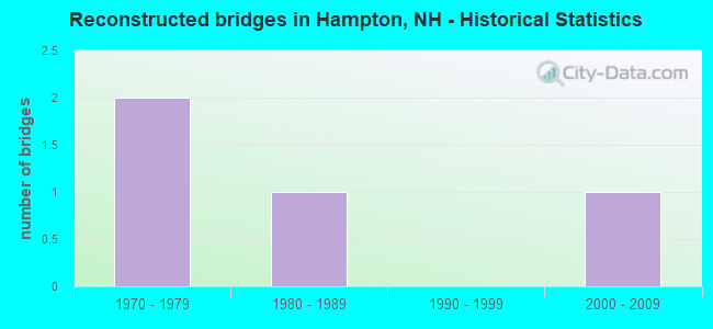
- Reconstructed bridges - Historical Statistics
- 21970-1979
- 11980-1989
- 01990-1999
- 12000-2009
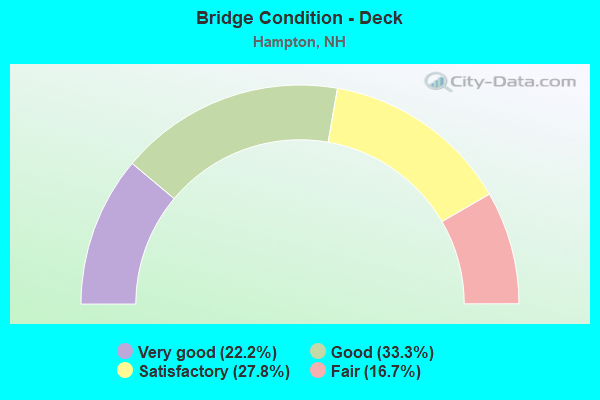
- Bridge Condition - Deck
- 22.2%Very good
- 33.3%Good
- 27.8%Satisfactory
- 16.7%Fair
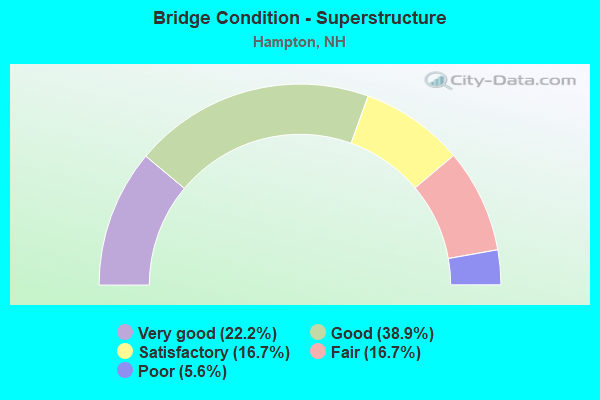
- Bridge Condition - Superstructure
- 22.2%Very good
- 38.9%Good
- 16.7%Satisfactory
- 16.7%Fair
- 5.6%Poor
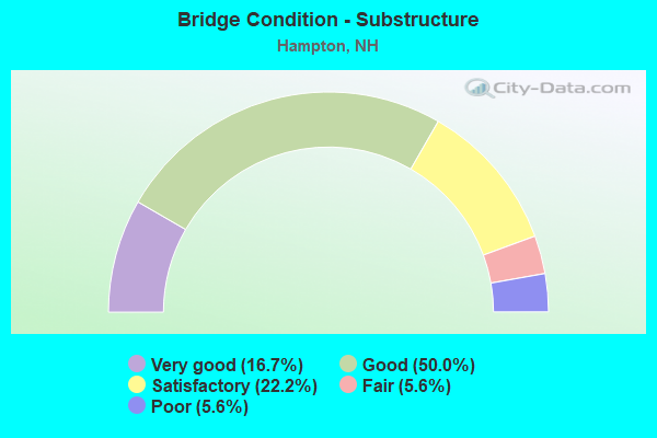
- Bridge Condition - Substructure
- 16.7%Very good
- 50.0%Good
- 22.2%Satisfactory
- 5.6%Fair
- 5.6%Poor
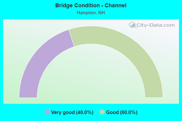
- Bridge Condition - Channel
- 40.0%Very good
- 60.0%Good
Find on map >> Show street view
Structure Number: 111009600108, Location: AT HAMPTON FALLS TL (Lat: 42.936619, Lng: -70.874239), Route carried "on" structure: Other road , Year Built: 1977, Status: Open, Structure Length: 0.82m (2.69ft), Average Daily Traffic: 2,041 (year 2020), Truck Traffic: 4%, Average Future Daily Traffic: 3,020 (year 2042), Design Load: HS 20, Features Intersected: TAYLOR RIVER, Facility Carried by Structure: TOWLE FARM ROAD
Minimum Vertical Clearance: 30+ m (98+ ft), Kilometerpoint: 0.364, Lanes on structure: 2, Owner: City or Municipal Highway Agency, Approaching Roadway Width: 8.5m (27.9ft), Skew: 1 degrees, Material/Design: Concrete, Design/Construction: Slab, Number Of Spans In Main Unit: 1, Length of Maximum Span: 7.6m (24.9ft), Curb-To-Curb Width: 8.1m (26.6ft), Out-to-Out Width: 9.3m (30.5ft)
Condition: Deck: Good, Superstructure: Very good, Substructure: Good, Channel: Good, Operating Rating: 70.4 metric tons, Method Used To Determine Operating Rating: Load Factor (LF), Inventory Rating: 42.1 metric tons, Method Used To Determine Inventory Rating: Load Factor (LF), Structural Evaluation: Better than present minimum criteria, Deck Geometry: High priority of corrective action, Waterway Adequacy: Equal to present desirable criteria, Approach Roadway Alignment: Equal to present desirable criteria, Length Of Structure Improvement: 0.82m (2.69ft), Designated Inspection Frequency: Every 24 months, Inspection Date: August 2020, Bridge Improvement Cost: $2,718,000, Roadway Improvement Cost: $200,000, Total Project Cost: $3,142,000 ( Estimate for 2022), Deck Structure Type: Concrete Cast-file-Place, Wearing Surface/Protective System: Wearing Surface: Bituminous
Find on map >> Show street view
Structure Number: 111009800182, Location: AT I-95 INTERCHANGE (Lat: 42.961722, Lng: -70.863508), Route carried "on" structure: Ramp Other road 95, Year Built: 1976, Status: Open, Structure Length: 7.13m (23.39ft), Average Daily Traffic: 17,103 (year 2020), Truck Traffic: 9%, Average Future Daily Traffic: 25,312 (year 2042), Design Load: HS 20+Mod, Features Intersected: NH101
Minimum Vertical Clearance: 30+ m (98+ ft), Kilometerpoint: 0.702, Lanes on structure: 2, Lanes under structure: 4, Base Highway Network: Yes, Toll: On toll road, Owner: State Toll Authority, Approaching Roadway Width: 17.7m (58.1ft), Skew: 20 degrees, Material/Design: Steel continuous, Design/Construction: Stringer/Multi-beam, Number Of Spans In Main Unit: 2, Length of Maximum Span: 35.7m (117.1ft), Curb or Sidewalk Widths: Left: 0.2m (0.7ft), Right: 0.2m (0.7ft), Curb-To-Curb Width: 17.7m (58.1ft), Out-to-Out Width: 18.5m (60.7ft)
Condition: Deck: Satisfactory, Superstructure: Good, Substructure: Good, Operating Rating: 56.2 metric tons, Method Used To Determine Operating Rating: Load Factor (LF), Inventory Rating: 33.7 metric tons, Method Used To Determine Inventory Rating: Load Factor (LF), Structural Evaluation: Better than present minimum criteria, Deck Geometry: Superior to present desirable criteria, Underclear: Somewhat better than minimum adequacy, Approach Roadway Alignment: Equal to present desirable criteria, Length Of Structure Improvement: 7.13m (23.39ft), Designated Inspection Frequency: Every 24 months, Inspection Date: May 2021, Bridge Improvement Cost: $2,718,000, Roadway Improvement Cost: $200,000, Total Project Cost: $3,142,000 ( Estimate for 2022), Deck Structure Type: Concrete Cast-file-Place, Wearing Surface/Protective System: Wearing Surface: Bituminous, Membrane: Other
Find on map >> Show street view
Structure Number: 11101120018, Location: HAMPTON (Lat: 42.959700, Lng: -70.856844), Route carried "on" structure: Interstate 101, Year Built: 2000, Status: Open, Structure Length: 10.45m (34.28ft), Average Daily Traffic: 8,158 (year 2020), Truck Traffic: 6%, Average Future Daily Traffic: 12,073 (year 2042), Design Load: HS 25 or greater, Features Intersected: I-95
Minimum Vertical Clearance: 30+ m (98+ ft), Kilometerpoint: 33.914, Lanes on structure: 4, Lanes under structure: 10, Base Highway Network: Yes, Owner: State Toll Authority, Approaching Roadway Width: 18.6m (61.0ft), Skew: 2 degrees, Material/Design: Steel continuous, Design/Construction: Stringer/Multi-beam, Number Of Spans In Main Unit: 2, Length of Maximum Span: 53.2m (174.5ft), Curb or Sidewalk Widths: Left: 0.1m (0.3ft), Right: 0.1m (0.3ft), Curb-To-Curb Width: 18.4m (60.4ft), Out-to-Out Width: 19.4m (63.6ft)
Condition: Deck: Very good, Superstructure: Good, Substructure: Very good, Operating Rating: 86.2 metric tons, Method Used To Determine Operating Rating: Load Factor (LF), Inventory Rating: 51.6 metric tons, Method Used To Determine Inventory Rating: Load Factor (LF), Structural Evaluation: Better than present minimum criteria, Deck Geometry: Somewhat better than minimum adequacy, Underclear: Better than present minimum criteria, Approach Roadway Alignment: Superior to present desirable criteria, Length Of Structure Improvement: 10.45m (34.28ft), Designated Inspection Frequency: Every 24 months, Inspection Date: May 2021, Bridge Improvement Cost: $2,718,000, Roadway Improvement Cost: $200,000, Total Project Cost: $3,142,000 ( Estimate for 2022), Deck Structure Type: Concrete Cast-file-Place, Wearing Surface/Protective System: Wearing Surface: Bituminous, Membrane: Preformed Fabric, Deck Protection: Epoxy Coated Reinforcing
Find on map >> Show street view
Structure Number: 111011300168, Location: .5 MI N. HAMPTON T.L. (Lat: 42.956019, Lng: -70.857575), Route carried "on" structure: State highway 27, Year Built: 1976, Status: Open, Structure Length: 8.96m (29.40ft), Average Daily Traffic: 8,789 (year 2020), Truck Traffic: 10%, Average Future Daily Traffic: 13,007 (year 2042), Design Load: HS 20+Mod, Features Intersected: I-95
Minimum Vertical Clearance: 30+ m (98+ ft), Kilometerpoint: 54.270, Lanes on structure: 2, Lanes under structure: 8, Owner: State Toll Authority, Approaching Roadway Width: 13.4m (44.0ft), Skew: 1 degrees, Material/Design: Steel continuous, Design/Construction: Stringer/Multi-beam, Number Of Spans In Main Unit: 2, Length of Maximum Span: 44.8m (147.0ft), Curb or Sidewalk Widths: Left: 1.5m (4.9ft), Right: 1.5m (4.9ft), Curb-To-Curb Width: 13.4m (44.0ft), Out-to-Out Width: 17.3m (56.8ft)
Condition: Deck: Satisfactory, Superstructure: Satisfactory, Substructure: Good, Operating Rating: 48.8 metric tons, Method Used To Determine Operating Rating: Load Factor (LF), Inventory Rating: 29.2 metric tons, Method Used To Determine Inventory Rating: Load Factor (LF), Structural Evaluation: Equal to present minimum criteria, Deck Geometry: Equal to present minimum criteria, Underclear: Somewhat better than minimum adequacy, Approach Roadway Alignment: Equal to present desirable criteria, Length Of Structure Improvement: 8.96m (29.40ft), Designated Inspection Frequency: Every 24 months, Inspection Date: May 2021, Bridge Improvement Cost: $2,718,000, Roadway Improvement Cost: $200,000, Total Project Cost: $3,142,000 ( Estimate for 2022), Deck Structure Type: Concrete Cast-file-Place, Wearing Surface/Protective System: Wearing Surface: Bituminous
Find on map >> Show street view
Structure Number: 111011500157, Location: .3 MI FROM JCT RT 101 (Lat: 42.952267, Lng: -70.858358), Route carried "on" structure: Interstate 95, Year Built: 1950, Year Reconstructed: 1976, Status: Open, Structure Length: 1.07m (3.51ft), Average Daily Traffic: 76,407 (year 2020), Truck Traffic: 9%, Average Future Daily Traffic: 113,082 (year 2042), Design Load: HS 20+Mod, Features Intersected: ACCESS ROAD
Minimum Vertical Clearance: 30+ m (98+ ft), Kilometerpoint: 8.177, Lanes on structure: 8, Lanes under structure: 2, Base Highway Network: Yes, Toll: On toll road, Owner: State Toll Authority, Approaching Roadway Width: 22.3m (73.2ft), Skew: 20 degrees, Material/Design: Concrete, Design/Construction: Frame, Number Of Spans In Main Unit: 1, Length of Maximum Span: 9.1m (29.9ft), Curb-To-Curb Width: 44.5m (146.0ft), Out-to-Out Width: 58.1m (190.6ft)
Condition: Deck: Fair, Superstructure: Fair, Substructure: Good, Operating Rating: 80.8 metric tons, Method Used To Determine Operating Rating: Load Factor (LF), Inventory Rating: 48.5 metric tons, Method Used To Determine Inventory Rating: Load Factor (LF), Structural Evaluation: Somewhat better than minimum adequacy, Deck Geometry: Superior to present desirable criteria, Underclear: High priority of replacement, Approach Roadway Alignment: Equal to present desirable criteria, Length Of Structure Improvement: 1.07m (3.51ft), Designated Inspection Frequency: Every 24 months, Inspection Date: May 2021, Bridge Improvement Cost: $2,718,000, Roadway Improvement Cost: $200,000, Total Project Cost: $3,142,000 ( Estimate for 2022), Deck Structure Type: Concrete Cast-file-Place, Wearing Surface/Protective System: Wearing Surface: Bituminous, Membrane: Other
Find on map >> Show street view
Structure Number: 111011800129, Location: 0.8 MI HAMPTON FALLS TL (Lat: 42.942317, Lng: -70.860431), Route carried "on" structure: Other road , Year Built: 1974, Status: Open, Structure Length: 8.05m (26.41ft), Average Daily Traffic: 2,041 (year 2020), Truck Traffic: 4%, Average Future Daily Traffic: 3,020 (year 2042), Design Load: HS 20+Mod, Features Intersected: I-95, Facility Carried by Structure: TOWLE FARM ROAD
Minimum Vertical Clearance: 30+ m (98+ ft), Kilometerpoint: 1.407, Lanes on structure: 2, Lanes under structure: 8, Owner: State Toll Authority, Approaching Roadway Width: 7.3m (24.0ft), Skew: 1 degrees, Material/Design: Steel continuous, Design/Construction: Stringer/Multi-beam, Number Of Spans In Main Unit: 2, Length of Maximum Span: 39.6m (129.9ft), Curb or Sidewalk Widths: Left: 1.5m (4.9ft), Right: 0.2m (0.7ft), Curb-To-Curb Width: 13.4m (44.0ft), Out-to-Out Width: 15.7m (51.5ft)
Condition: Deck: Satisfactory, Superstructure: Good, Substructure: Good, Operating Rating: 43.5 metric tons, Method Used To Determine Operating Rating: Field evaluation and documented engineering judgment, Inventory Rating: 32.7 metric tons, Method Used To Determine Inventory Rating: Field evaluation and documented engineering judgment, Structural Evaluation: Better than present minimum criteria, Deck Geometry: Better than present minimum criteria, Underclear: Equal to present minimum criteria, Approach Roadway Alignment: Equal to present desirable criteria, Length Of Structure Improvement: 8.05m (26.41ft), Designated Inspection Frequency: Every 24 months, Inspection Date: May 2021, Bridge Improvement Cost: $2,718,000, Roadway Improvement Cost: $200,000, Total Project Cost: $3,142,000 ( Estimate for 2022), Deck Structure Type: Concrete Cast-file-Place, Wearing Surface/Protective System: Wearing Surface: Bituminous, Membrane: Other
Find on map >> Show street view
Structure Number: 111012000103, Location: 3.75 MI N of MA S/L (Lat: 42.933769, Lng: -70.863006), Route carried "on" structure: Interstate 95, Year Built: 2018, Status: Open, Structure Length: 2.50m (8.20ft), Average Daily Traffic: 39,743 (year 2020), Truck Traffic: 9%, Average Future Daily Traffic: 58,819 (year 2042), Design Load: HL 93, Features Intersected: TAYLOR RIVER
Minimum Vertical Clearance: 30+ m (98+ ft), Kilometerpoint: 19.988, Lanes on structure: 4, Base Highway Network: Yes, Toll: On toll road, Owner: State Toll Authority, Approaching Roadway Width: 22.3m (73.2ft), Material/Design: Prestressed concrete, Design/Construction: Tee Beam, Number Of Spans In Main Unit: 1, Length of Maximum Span: 22.0m (72.2ft), Curb or Sidewalk Widths: Left: 0.2m (0.7ft), Right: 0.2m (0.7ft), Curb-To-Curb Width: 22.3m (73.2ft), Out-to-Out Width: 23.1m (75.8ft)
Condition: Deck: Very good, Superstructure: Very good, Substructure: Very good, Channel: Very good, Operating Rating: 84.3 metric tons, Method Used To Determine Operating Rating: Load and Resistance Factor (LRFR), Inventory Rating: 50.8 metric tons, Method Used To Determine Inventory Rating: Load and Resistance Factor (LRFR), Structural Evaluation: Equal to present desirable criteria, Deck Geometry: Superior to present desirable criteria, Waterway Adequacy: Equal to present desirable criteria, Approach Roadway Alignment: Equal to present desirable criteria, Length Of Structure Improvement: 2.50m (8.20ft), Designated Inspection Frequency: Every 24 months, Inspection Date: May 2021, Bridge Improvement Cost: $2,718,000, Roadway Improvement Cost: $200,000, Total Project Cost: $3,142,000 ( Estimate for 2022), Deck Structure Type: Concrete Cast-file-Place, Wearing Surface/Protective System: Wearing Surface: Integral Concrete, Deck Protection: Epoxy Coated Reinforcing
Find on map >> Show street view
Structure Number: 111012100103, Location: 3.75 MI N of MA S/L (Lat: 42.933656, Lng: -70.862606), Route carried "on" structure: Interstate 95, Year Built: 2018, Status: Open, Structure Length: 2.50m (8.20ft), Average Daily Traffic: 36,664 (year 2020), Truck Traffic: 9%, Average Future Daily Traffic: 54,262 (year 2042), Design Load: HL 93, Features Intersected: TAYLOR RIVER
Minimum Vertical Clearance: 30+ m (98+ ft), Kilometerpoint: 6.075, Lanes on structure: 5, Base Highway Network: Yes, Toll: On toll road, Owner: State Toll Authority, Approaching Roadway Width: 26.2m (86.0ft), Material/Design: Concrete, Design/Construction: Tee Beam, Number Of Spans In Main Unit: 1, Length of Maximum Span: 22.6m (74.1ft), Curb or Sidewalk Widths: Left: 0.2m (0.7ft), Right: 0.2m (0.7ft), Curb-To-Curb Width: 26.2m (86.0ft), Out-to-Out Width: 27.0m (88.6ft)
Condition: Deck: Very good, Superstructure: Very good, Substructure: Very good, Channel: Very good, Operating Rating: 84.5 metric tons, Method Used To Determine Operating Rating: Load and Resistance Factor (LRFR), Inventory Rating: 50.8 metric tons, Method Used To Determine Inventory Rating: Load and Resistance Factor (LRFR), Structural Evaluation: Equal to present desirable criteria, Deck Geometry: Superior to present desirable criteria, Waterway Adequacy: Superior to present desirable criteria, Approach Roadway Alignment: Equal to present desirable criteria, Length Of Structure Improvement: 2.50m (8.20ft), Designated Inspection Frequency: Every 24 months, Inspection Date: May 2021, Bridge Improvement Cost: $2,718,000, Roadway Improvement Cost: $200,000, Total Project Cost: $3,142,000 ( Estimate for 2022), Deck Structure Type: Concrete Cast-file-Place, Wearing Surface/Protective System: Wearing Surface: Integral Concrete, Deck Protection: Epoxy Coated Reinforcing
Find on map >> Show street view
Structure Number: 111012300173, Location: .3 MI FROM JCT. I-95 (Lat: 42.956158, Lng: -70.853042), Route carried "on" structure: State highway 101C, Year Built: 1996, Status: Open, Structure Length: 7.13m (23.39ft), Average Daily Traffic: 8,789 (year 2020), Truck Traffic: 2%, Average Future Daily Traffic: 13,007 (year 2042), Design Load: HS 25 or greater, Features Intersected: NH101, Facility Carried by Structure: NH 27
Minimum Vertical Clearance: 30+ m (98+ ft), Kilometerpoint: 54.637, Lanes on structure: 3, Lanes under structure: 4, Owner: State Highway Agency, Approaching Roadway Width: 16.8m (55.1ft), Skew: 2 degrees, Material/Design: Steel continuous, Design/Construction: Stringer/Multi-beam, Number Of Spans In Main Unit: 2, Length of Maximum Span: 36.6m (120.1ft), Curb or Sidewalk Widths: Left: 0.2m (0.7ft), Right: 1.5m (4.9ft), Curb-To-Curb Width: 16.9m (55.4ft), Out-to-Out Width: 19.4m (63.6ft)
Condition: Deck: Good, Superstructure: Good, Substructure: Good, Operating Rating: 89.8 metric tons, Method Used To Determine Operating Rating: Load Factor (LF), Inventory Rating: 53.9 metric tons, Method Used To Determine Inventory Rating: Load Factor (LF), Structural Evaluation: Better than present minimum criteria, Deck Geometry: Superior to present desirable criteria, Underclear: Somewhat better than minimum adequacy, Approach Roadway Alignment: Equal to present desirable criteria, Length Of Structure Improvement: 7.13m (23.39ft), Designated Inspection Frequency: Every 24 months, Inspection Date: May 2021, Bridge Improvement Cost: $2,718,000, Roadway Improvement Cost: $200,000, Total Project Cost: $3,142,000 ( Estimate for 2022), Deck Structure Type: Concrete Cast-file-Place, Wearing Surface/Protective System: Wearing Surface: Bituminous, Membrane: Preformed Fabric, Deck Protection: Epoxy Coated Reinforcing
Find on map >> Show street view
Structure Number: 111013500144, Location: 0.3 MI FROM JCT. RT 95 (Lat: 42.945436, Lng: -70.850817), Route carried "on" structure: Other road , Year Built: 1995, Status: Open, Structure Length: 2.87m (9.42ft), Average Daily Traffic: 2,041 (year 2020), Truck Traffic: 2%, Average Future Daily Traffic: 3,020 (year 2042), Design Load: HS 25 or greater, Features Intersected: NH101, Facility Carried by Structure: TOWLE FARM ROAD
Minimum Vertical Clearance: 30+ m (98+ ft), Kilometerpoint: 2.264, Lanes on structure: 2, Lanes under structure: 2, Owner: State Highway Agency, Approaching Roadway Width: 13.1m (43.0ft), Skew: 1 degrees, Material/Design: Steel, Design/Construction: Stringer/Multi-beam, Number Of Spans In Main Unit: 1, Length of Maximum Span: 26.8m (87.9ft), Curb or Sidewalk Widths: Left: 0.2m (0.7ft), Right: 0.2m (0.7ft), Curb-To-Curb Width: 13.3m (43.6ft), Out-to-Out Width: 14.5m (47.6ft)
Condition: Deck: Good, Superstructure: Good, Substructure: Good, Operating Rating: 86.4 metric tons, Method Used To Determine Operating Rating: Load Factor (LF), Inventory Rating: 51.8 metric tons, Method Used To Determine Inventory Rating: Load Factor (LF), Structural Evaluation: Better than present minimum criteria, Deck Geometry: Equal to present minimum criteria, Underclear: Equal to present minimum criteria, Approach Roadway Alignment: Equal to present desirable criteria, Length Of Structure Improvement: 2.87m (9.42ft), Designated Inspection Frequency: Every 24 months, Inspection Date: May 2021, Bridge Improvement Cost: $2,718,000, Roadway Improvement Cost: $200,000, Total Project Cost: $3,142,000 ( Estimate for 2022), Deck Structure Type: Concrete Cast-file-Place, Wearing Surface/Protective System: Wearing Surface: Bituminous, Membrane: Preformed Fabric, Deck Protection: Epoxy Coated Reinforcing
Find on map >> Show street view
Structure Number: 111014600087, Location: 0.1 MI HAMPTON FALLS TL (Lat: 42.924692, Lng: -70.852625), Route carried "on" structure: US 1, Year Built: 1965, Status: Open, Structure Length: 1.07m (3.51ft), Average Daily Traffic: 18,847 (year 2020), Truck Traffic: 5%, Average Future Daily Traffic: 27,893 (year 2042), Design Load: HS 20, Features Intersected: TAYLOR RIVER
Minimum Vertical Clearance: 30+ m (98+ ft), Kilometerpoint: 6.404, Lanes on structure: 3, Owner: State Highway Agency, Approaching Roadway Width: 12.2m (40.0ft), Material/Design: Prestressed concrete, Design/Construction: Slab, Number Of Spans In Main Unit: 1, Length of Maximum Span: 9.8m (32.2ft), Curb or Sidewalk Widths: Left: 0.1m (0.3ft), Right: 0.1m (0.3ft), Curb-To-Curb Width: 15.8m (51.8ft), Out-to-Out Width: 17.4m (57.1ft)
Condition: Deck: Good, Superstructure: Good, Substructure: Satisfactory, Channel: Good, Operating Rating: 78.9 metric tons, Method Used To Determine Operating Rating: Load Factor (LF), Inventory Rating: 47.2 metric tons, Method Used To Determine Inventory Rating: Load Factor (LF), Structural Evaluation: Equal to present minimum criteria, Deck Geometry: Better than present minimum criteria, Waterway Adequacy: Equal to present desirable criteria, Approach Roadway Alignment: Equal to present desirable criteria, Length Of Structure Improvement: 1.07m (3.51ft), Designated Inspection Frequency: Every 24 months, Inspection Date: May 2021, Bridge Improvement Cost: $2,718,000, Roadway Improvement Cost: $200,000, Total Project Cost: $3,142,000 ( Estimate for 2022), Deck Structure Type: Concrete Precast Panels, Wearing Surface/Protective System: Wearing Surface: Bituminous, Membrane: Other
Find on map >> Show street view
Structure Number: 111015800119, Location: 0.6 MI FROM JCT 101C (Lat: 42.934408, Lng: -70.843244), Route carried "on" structure: State highway 51, Year Built: 1963, Status: Open, Structure Length: 4.69m (15.39ft), Average Daily Traffic: 9,803 (year 2020), Average Future Daily Traffic: 14,508 (year 2042), Design Load: HS 20+Mod, Features Intersected: DRAKESIDE ROAD, Facility Carried by Structure: NH101
Minimum Vertical Clearance: 30+ m (98+ ft), Kilometerpoint: 149.486, Lanes on structure: 2, Lanes under structure: 2, Base Highway Network: Yes, Owner: State Highway Agency, Approaching Roadway Width: 13.4m (44.0ft), Skew: 4 degrees, Material/Design: Steel continuous, Design/Construction: Stringer/Multi-beam, Number Of Spans In Main Unit: 3, Length of Maximum Span: 17.1m (56.1ft), Curb or Sidewalk Widths: Left: 0.5m (1.6ft), Right: 0.5m (1.6ft), Curb-To-Curb Width: 14.6m (47.9ft), Out-to-Out Width: 16.4m (53.8ft)
Condition: Deck: Fair, Superstructure: Good, Substructure: Satisfactory, Operating Rating: 57.6 metric tons, Method Used To Determine Operating Rating: Load Factor (LF), Inventory Rating: 34.6 metric tons, Method Used To Determine Inventory Rating: Load Factor (LF), Structural Evaluation: Equal to present minimum criteria, Deck Geometry: Superior to present desirable criteria, Underclear: Meets minimum limits, Approach Roadway Alignment: Equal to present desirable criteria, Length Of Structure Improvement: 4.69m (15.39ft), Designated Inspection Frequency: Every 24 months, Inspection Date: May 2021, Bridge Improvement Cost: $2,718,000, Roadway Improvement Cost: $200,000, Total Project Cost: $3,142,000 ( Estimate for 2022), Deck Structure Type: Concrete Cast-file-Place, Wearing Surface/Protective System: Wearing Surface: Bituminous, Membrane: Other
Find on map >> Show street view
Structure Number: 111016200104, Location: .1 MI FROM JCT. RT 1 (Lat: 42.929881, Lng: -70.843339), Route carried "on" structure: Ramp US 1, Year Built: 1963, Status: Open, Structure Length: 3.20m (10.50ft), Average Daily Traffic: 9,661 (year 2020), Truck Traffic: 4%, Average Future Daily Traffic: 14,298 (year 2042), Features Intersected: NHRR(ABD)
Minimum Vertical Clearance: 30+ m (98+ ft), Kilometerpoint: 7.411, Lanes on structure: 3, Owner: State Highway Agency, Approaching Roadway Width: 12.2m (40.0ft), Skew: 1 degrees, Material/Design: Steel continuous, Design/Construction: Stringer/Multi-beam, Number Of Spans In Main Unit: 3, Length of Maximum Span: 11.0m (36.1ft), Curb or Sidewalk Widths: Left: 0.1m (0.3ft), Right: 0.1m (0.3ft), Curb-To-Curb Width: 14.6m (47.9ft), Out-to-Out Width: 16.2m (53.1ft)
Condition: Deck: Good, Superstructure: Satisfactory, Substructure: Good, Operating Rating: 61.7 metric tons, Method Used To Determine Operating Rating: Allowable Stress (AS), Inventory Rating: 37.2 metric tons, Method Used To Determine Inventory Rating: Allowable Stress (AS), Structural Evaluation: Equal to present minimum criteria, Deck Geometry: Better than present minimum criteria, Approach Roadway Alignment: Equal to present desirable criteria, Length Of Structure Improvement: 3.20m (10.50ft), Designated Inspection Frequency: Every 24 months, Inspection Date: May 2021, Bridge Improvement Cost: $2,718,000, Roadway Improvement Cost: $200,000, Total Project Cost: $3,142,000 ( Estimate for 2022), Deck Structure Type: Concrete Cast-file-Place, Wearing Surface/Protective System: Wearing Surface: Bituminous, Membrane: Other
Find on map >> Show street view
Structure Number: 111016200112, Location: .1 MI. FROM JCT RT 101 BY (Lat: 42.931839, Lng: -70.842536), Route carried "on" structure: US 1, Year Built: 1936, Year Reconstructed: 1994, Status: Open, Structure Length: 1.49m (4.89ft), Average Daily Traffic: 9,965 (year 2020), Truck Traffic: 5%, Average Future Daily Traffic: 14,748 (year 2042), Design Load: H 20, Features Intersected: NHRR(ABD)
Minimum Vertical Clearance: 30+ m (98+ ft), Kilometerpoint: 3.795, Lanes on structure: 2, Base Highway Network: Yes, Owner: State Highway Agency, Approaching Roadway Width: 10.7m (35.1ft), Skew: 4 degrees, Material/Design: Concrete, Design/Construction: Tee Beam, Number Of Spans In Main Unit: 1, Length of Maximum Span: 14.3m (46.9ft), Curb or Sidewalk Widths: Left: 0.7m (2.3ft), Right: 0.5m (1.6ft), Curb-To-Curb Width: 10.6m (34.8ft), Out-to-Out Width: 13.0m (42.7ft)
Condition: Deck: Fair, Superstructure: Fair, Substructure: Fair, Operating Rating: 65.8 metric tons, Method Used To Determine Operating Rating: Load Factor (LF), Inventory Rating: 39.4 metric tons, Method Used To Determine Inventory Rating: Load Factor (LF), Structural Evaluation: Somewhat better than minimum adequacy, Deck Geometry: Somewhat better than minimum adequacy, Approach Roadway Alignment: Equal to present desirable criteria, Length Of Structure Improvement: 1.49m (4.89ft), Designated Inspection Frequency: Every 24 months, Inspection Date: May 2021, Bridge Improvement Cost: $2,718,000, Roadway Improvement Cost: $200,000, Total Project Cost: $3,142,000 ( Estimate for 2022), Deck Structure Type: Concrete Cast-file-Place, Wearing Surface/Protective System: Wearing Surface: Bituminous
Find on map >> Show street view
Structure Number: 111016200142, Location: 3.8 MI E. EXET-HAMP T.L. (Lat: 42.942283, Lng: -70.838606), Route carried "on" structure: State highway 27, Year Built: 1926, Year Reconstructed: 2006, Status: Open, Structure Length: 1.16m (3.81ft), Average Daily Traffic: 9,559 (year 2020), Truck Traffic: 5%, Average Future Daily Traffic: 14,147 (year 2042), Design Load: HS 25 or greater, Features Intersected: PAR(ABD)
Minimum Vertical Clearance: 30+ m (98+ ft), Kilometerpoint: 56.744, Lanes on structure: 2, Owner: City or Municipal Highway Agency, Approaching Roadway Width: 7.9m (25.9ft), Skew: 2 degrees, Material/Design: Prestressed concrete, Design/Construction: Slab, Number Of Spans In Main Unit: 1, Length of Maximum Span: 10.2m (33.5ft), Curb or Sidewalk Widths: Left: 1.5m (4.9ft), Right: 0.1m (0.3ft), Curb-To-Curb Width: 9.9m (32.5ft), Out-to-Out Width: 12.8m (42.0ft)
Condition: Deck: Very good, Superstructure: Very good, Substructure: Good, Operating Rating: 76.0 metric tons, Method Used To Determine Operating Rating: Load Factor (LF), Inventory Rating: 45.5 metric tons, Method Used To Determine Inventory Rating: Load Factor (LF), Structural Evaluation: Better than present minimum criteria, Deck Geometry: Meets minimum limits, Underclear: High priority of replacement, Approach Roadway Alignment: Equal to present minimum criteria, Length Of Structure Improvement: 1.16m (3.81ft), Designated Inspection Frequency: Every 24 months, Inspection Date: August 2020, Bridge Improvement Cost: $2,718,000, Roadway Improvement Cost: $200,000, Total Project Cost: $3,142,000 ( Estimate for 2022), Deck Structure Type: Concrete Precast Panels, Wearing Surface/Protective System: Wearing Surface: Bituminous, Membrane: Other
Find on map >> Show street view
Structure Number: 111016300184, Location: 0.1 MI FROM N HAMPTON TL (Lat: 42.957283, Lng: -70.833661), Route carried "on" structure: US 1, Year Built: 1936, Year Reconstructed: 1977, Status: Open, Structure Length: 3.66m (12.01ft), Average Daily Traffic: 14,258 (year 2020), Truck Traffic: 5%, Average Future Daily Traffic: 21,101 (year 2042), Design Load: H 20, Features Intersected: PAR(ABD)
Minimum Vertical Clearance: 30+ m (98+ ft), Kilometerpoint: 11.019, Lanes on structure: 3, Base Highway Network: Yes, Owner: State Highway Agency, Approaching Roadway Width: 11.0m (36.1ft), Skew: 7 degrees, Material/Design: Steel continuous, Design/Construction: Girder and Floorbeam System, Number Of Spans In Main Unit: 1, Length of Maximum Span: 32.9m (107.9ft), Curb or Sidewalk Widths: Left: 1.2m (3.9ft), Right: 1.2m (3.9ft), Curb-To-Curb Width: 10.4m (34.1ft), Out-to-Out Width: 12.2m (40.0ft)
Condition: Deck: Satisfactory, Superstructure: Poor, Substructure: Poor, Operating Rating: 38.7 metric tons, Method Used To Determine Operating Rating: Load Factor (LF), Inventory Rating: 23.2 metric tons, Method Used To Determine Inventory Rating: Load Factor (LF), Structural Evaluation: Meets minimum limits, Deck Geometry: High priority of replacement, Underclear: High priority of replacement, Approach Roadway Alignment: Equal to present desirable criteria, Length Of Structure Improvement: 3.66m (12.01ft), Designated Inspection Frequency: Every 8 months, Critical Feature Inspection Frequency: Every 24 months, Inspection Date: November 2021, Critical Feature Inspection Date: April 2021, Bridge Improvement Cost: $2,718,000, Roadway Improvement Cost: $200,000, Total Project Cost: $3,142,000 ( Estimate for 2022), Deck Structure Type: Concrete Cast-file-Place, Wearing Surface/Protective System: Wearing Surface: Bituminous
Find on map >> Show street view
Structure Number: 111016500113, Location: 2.3 MI. FROM JCT. RT 95 (Lat: 42.932508, Lng: -70.840808), Route carried "on" structure: State highway 51, Year Built: 1963, Status: Open, Structure Length: 3.69m (12.11ft), Average Daily Traffic: 7,365 (year 2020), Truck Traffic: 5%, Average Future Daily Traffic: 10,900 (year 2042), Design Load: HS 20+Mod, Features Intersected: US 1 SB, Facility Carried by Structure: NH101
Minimum Vertical Clearance: 30+ m (98+ ft), Kilometerpoint: 149.777, Lanes on structure: 2, Lanes under structure: 2, Base Highway Network: Yes, Owner: State Highway Agency, Approaching Roadway Width: 13.4m (44.0ft), Skew: 3 degrees, Material/Design: Steel continuous, Design/Construction: Stringer/Multi-beam, Number Of Spans In Main Unit: 3, Length of Maximum Span: 14.9m (48.9ft), Curb or Sidewalk Widths: Left: 0.5m (1.6ft), Right: 0.5m (1.6ft), Curb-To-Curb Width: 13.4m (44.0ft), Out-to-Out Width: 15.2m (49.9ft)
Condition: Deck: Good, Superstructure: Satisfactory, Substructure: Satisfactory, Operating Rating: 59.4 metric tons, Method Used To Determine Operating Rating: Load Factor (LF), Inventory Rating: 35.6 metric tons, Method Used To Determine Inventory Rating: Load Factor (LF), Structural Evaluation: Equal to present minimum criteria, Deck Geometry: Equal to present minimum criteria, Underclear: High priority of replacement, Approach Roadway Alignment: Equal to present desirable criteria, Length Of Structure Improvement: 3.69m (12.11ft), Designated Inspection Frequency: Every 24 months, Inspection Date: May 2021, Bridge Improvement Cost: $2,718,000, Roadway Improvement Cost: $200,000, Total Project Cost: $3,142,000 ( Estimate for 2022), Deck Structure Type: Concrete Cast-file-Place, Wearing Surface/Protective System: Wearing Surface: Bituminous, Membrane: Other
Find on map >> Show street view
Structure Number: 111017100109, Location: 2.3 MI. FROM JCT. I-95 (Lat: 42.930878, Lng: -70.837989), Route carried "on" structure: State highway 51, Year Built: 1963, Status: Open, Structure Length: 3.99m (13.09ft), Average Daily Traffic: 6,232 (year 2020), Truck Traffic: 5%, Average Future Daily Traffic: 9,223 (year 2042), Design Load: HS 20, Features Intersected: US 1 NB, Facility Carried by Structure: NH101
Minimum Vertical Clearance: 30+ m (98+ ft), Kilometerpoint: 150.070, Lanes on structure: 2, Lanes under structure: 2, Base Highway Network: Yes, Owner: State Highway Agency, Approaching Roadway Width: 11.6m (38.1ft), Material/Design: Steel, Design/Construction: Stringer/Multi-beam, Number Of Spans In Main Unit: 3, Length of Maximum Span: 17.7m (58.1ft), Curb or Sidewalk Widths: Left: 0.5m (1.6ft), Right: 0.5m (1.6ft), Curb-To-Curb Width: 12.2m (40.0ft), Out-to-Out Width: 14.0m (45.9ft)
Condition: Deck: Satisfactory, Superstructure: Fair, Substructure: Satisfactory, Operating Rating: 44.3 metric tons, Method Used To Determine Operating Rating: Load Factor (LF), Inventory Rating: 26.6 metric tons, Method Used To Determine Inventory Rating: Load Factor (LF), Structural Evaluation: Somewhat better than minimum adequacy, Deck Geometry: Somewhat better than minimum adequacy, Underclear: Somewhat better than minimum adequacy, Approach Roadway Alignment: Equal to present desirable criteria, Length Of Structure Improvement: 3.99m (13.09ft), Designated Inspection Frequency: Every 24 months, Inspection Date: May 2021, Bridge Improvement Cost: $2,718,000, Roadway Improvement Cost: $200,000, Total Project Cost: $3,142,000 ( Estimate for 2022), Deck Structure Type: Concrete Cast-file-Place, Wearing Surface/Protective System: Wearing Surface: Bituminous, Membrane: Other
Find on map >> Show street view
Structure Number: 11102470012, Location: .2 MI WEST JCT NH 1A (Lat: 42.927406, Lng: -70.800686), Route carried "on" structure: City street 101E, Year Built: 1997, Status: Open, Structure Length: 0.73m (2.40ft), Average Daily Traffic: 3,432 (year 2020), Truck Traffic: 7%, Average Future Daily Traffic: 5,079 (year 2042), Design Load: HS 25 or greater, Features Intersected: EEL CREEK
Minimum Vertical Clearance: 30+ m (98+ ft), Kilometerpoint: 3.582, Lanes on structure: 2, Owner: City or Municipal Highway Agency, Approaching Roadway Width: 8.8m (28.9ft), Material/Design: Concrete, Design/Construction: Culvert, Number Of Spans In Main Unit: 1, Length of Maximum Span: 7.3m (24.0ft), Curb or Sidewalk Widths: Left: 0.1m (0.3ft), Right: 0.1m (0.3ft)
Condition: Channel: Good, Culverts: Very good, Operating Rating: 73.9 metric tons, Method Used To Determine Operating Rating: Load Factor (LF), Inventory Rating: 44.5 metric tons, Method Used To Determine Inventory Rating: Load Factor (LF), Structural Evaluation: Equal to present desirable criteria, Waterway Adequacy: Better than present minimum criteria, Approach Roadway Alignment: Equal to present desirable criteria, Length Of Structure Improvement: 0.73m (2.40ft), Designated Inspection Frequency: Every 24 months, Inspection Date: August 2020, Bridge Improvement Cost: $2,718,000, Roadway Improvement Cost: $200,000, Total Project Cost: $3,142,000 ( Estimate for 2022)
Find on map >> Show street view
Structure Number: 111009800182, Location: AT I-95 INTERCHANGE (Lat: 42.961722, Lng: -70.863508), Route carried "under" structure: Interstate 51, Year Built: 1976, Structure Length: 0. m, Average Daily Traffic: 41,000 (year 2015), Truck Traffic: 7%, Features Intersected: NH101, Facility Carried by Structure: I-95 RAMP
Minimum Vertical Clearance: 5.00m (16.40ft), Kilometerpoint: 0.000, Lanes on structure: 2, Lanes under structure: 2, Material/Design: Steel continuous, Design/Construction: Stringer/Multi-beam, Length of Maximum Span: 35.7m (117.1ft)
Find on map >> Show street view
Structure Number: 111011200179, Location: 2.0 MI FROM EXETER TL (Lat: 42.959400, Lng: -70.856867), Route carried "under" structure: Interstate 95, Year Built: 1999, Structure Length: 0. m, Average Daily Traffic: 66,160 (year 2015), Truck Traffic: 9%, Features Intersected: I-95, Facility Carried by Structure: NH101 EB
Minimum Vertical Clearance: 5.00m (16.40ft), Kilometerpoint: 0.000, Lanes on structure: 2, Lanes under structure: 10, Toll: On toll road, Material/Design: Steel continuous, Design/Construction: Stringer/Multi-beam, Length of Maximum Span: 53.2m (174.5ft)
Find on map >> Show street view
Structure Number: 11101120018, Location: HAMPTON (Lat: 42.959700, Lng: -70.856844), Route carried "under" structure: Interstate 95, Year Built: 2000, Structure Length: 0. m, Average Daily Traffic: 66,160 (year 2015), Truck Traffic: 6%, Features Intersected: I-95, Facility Carried by Structure: NH101 WB
Minimum Vertical Clearance: 5.26m (17.26ft), Kilometerpoint: 2.410, Lanes on structure: 4, Lanes under structure: 10, Toll: On toll road, Material/Design: Steel continuous, Design/Construction: Stringer/Multi-beam, Length of Maximum Span: 53.2m (174.5ft)
Find on map >> Show street view
Structure Number: 111011300168, Location: .5 MI N. HAMPTON T.L. (Lat: 42.956019, Lng: -70.857575), Route carried "under" structure: Interstate 95, Year Built: 1976, Structure Length: 0. m, Average Daily Traffic: 63,884 (year 2014), Truck Traffic: 9%, Features Intersected: I-95, Facility Carried by Structure: NH 27
Minimum Vertical Clearance: 5.00m (16.40ft), Kilometerpoint: 0.000, Lanes on structure: 2, Lanes under structure: 8, Toll: On toll road, Material/Design: Steel continuous, Design/Construction: Stringer/Multi-beam, Length of Maximum Span: 44.8m (147.0ft)
Find on map >> Show street view
Structure Number: 111011500157, Location: .3 MI FROM JCT RT 101 (Lat: 42.952267, Lng: -70.858358), Route carried "under" structure: Ramp Interstate 95, Year Built: 1950, Structure Length: 0. m, Average Daily Traffic: 4,900 (year 2015), Truck Traffic: 9%, Features Intersected: ACCESS ROAD
Minimum Vertical Clearance: 4.29m (14.07ft), Kilometerpoint: 0.000, Lanes on structure: 8, Lanes under structure: 2, Material/Design: Concrete, Design/Construction: Frame, Length of Maximum Span: 9.1m (29.9ft)
Find on map >> Show street view
Structure Number: 111011800129, Location: 0.8 MI HAMPTON FALLS TL (Lat: 42.942317, Lng: -70.860431), Route carried "under" structure: Interstate 95, Year Built: 1974, Structure Length: 0. m, Average Daily Traffic: 84,000 (year 2015), Truck Traffic: 9%, Features Intersected: I-95, Facility Carried by Structure: TOWLE FARM ROAD
Minimum Vertical Clearance: 5.00m (16.40ft), Kilometerpoint: 0.000, Lanes on structure: 2, Lanes under structure: 8, Toll: On toll road, Material/Design: Steel continuous, Design/Construction: Stringer/Multi-beam, Length of Maximum Span: 39.6m (129.9ft)
Find on map >> Show street view
Structure Number: 111012300173, Location: .3 MI FROM JCT. I-95 (Lat: 42.956158, Lng: -70.853042), Route carried "under" structure: State highway 51, Year Built: 1996, Structure Length: 0. m, Average Daily Traffic: 20,000 (year 2012), Truck Traffic: 7%, Features Intersected: NH101, Facility Carried by Structure: NH 27
Minimum Vertical Clearance: 5.25m (17.22ft), Kilometerpoint: 0.000, Lanes on structure: 3, Lanes under structure: 4, Material/Design: Steel continuous, Design/Construction: Stringer/Multi-beam, Length of Maximum Span: 36.6m (120.1ft)
Find on map >> Show street view
Structure Number: 111013500144, Location: 0.3 MI FROM JCT. RT 95 (Lat: 42.945436, Lng: -70.850817), Route carried "under" structure: State highway 51, Year Built: 1995, Structure Length: 0. m, Average Daily Traffic: 18,000 (year 2015), Truck Traffic: 7%, Features Intersected: NH101, Facility Carried by Structure: TOWLE FARM ROAD
Minimum Vertical Clearance: 5.16m (16.93ft), Kilometerpoint: 0.000, Lanes on structure: 2, Lanes under structure: 2, Material/Design: Steel, Design/Construction: Stringer/Multi-beam, Length of Maximum Span: 26.8m (87.9ft)
Find on map >> Show street view
Structure Number: 111016500113, Location: 2.3 MI. FROM JCT. RT 95 (Lat: 42.932508, Lng: -70.840808), Route carried "under" structure: US 51, Year Built: 1963, Structure Length: 0. m, Average Daily Traffic: 20,373 (year 2014), Truck Traffic: 5%, Features Intersected: US 1 SB, Facility Carried by Structure: NH101
Minimum Vertical Clearance: 4.49m (14.73ft), Kilometerpoint: 0.000, Lanes on structure: 2, Lanes under structure: 2, Material/Design: Steel continuous, Design/Construction: Stringer/Multi-beam, Length of Maximum Span: 14.9m (48.9ft)
Find on map >> Show street view
Structure Number: 111017100109, Location: 2.3 MI. FROM JCT. I-95 (Lat: 42.930878, Lng: -70.837989), Route carried "under" structure: Ramp US 51, Year Built: 1963, Structure Length: 0. m, Average Daily Traffic: 14,000 (year 2013), Truck Traffic: 7%, Features Intersected: US 1 NB, Facility Carried by Structure: NH101
Minimum Vertical Clearance: 4.37m (14.34ft), Kilometerpoint: 0.000, Lanes on structure: 2, Lanes under structure: 2, Material/Design: Steel, Design/Construction: Stringer/Multi-beam, Length of Maximum Span: 17.7m (58.1ft)