Bridge Statistics for Heidelberg, Pennsylvania (PA)
Condition, Traffic, Stress, Structural Evaluation, Project Costs
- National Bridge Inventory (NBI) Statistics
- 18Number of bridges
- 367ft / 112mTotal length
- $19,708,000Total costs
- 345,024Total average daily traffic
- 61,748Total average daily truck traffic
- National Bridge Inventory (NBI) Registered Bridges for Heidelberg
- No street view available for this location
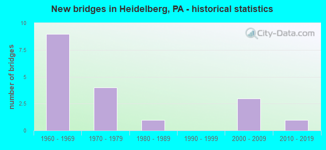
- New bridges - historical statistics
- 91960-1969
- 41970-1979
- 11980-1989
- 32000-2009
- 12010-2019
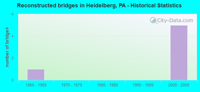
- Reconstructed bridges - Historical Statistics
- 11960-1969
- 01970-1979
- 01980-1989
- 01990-1999
- 52000-2009
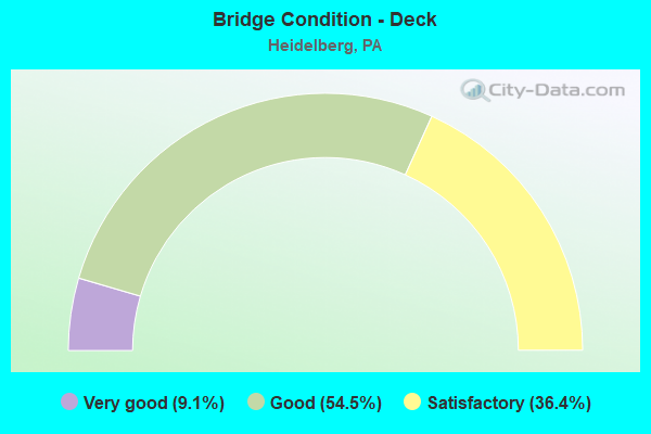
- Bridge Condition - Deck
- 9.1%Very good
- 54.5%Good
- 36.4%Satisfactory
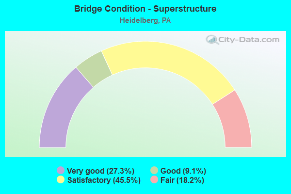
- Bridge Condition - Superstructure
- 27.3%Very good
- 9.1%Good
- 45.5%Satisfactory
- 18.2%Fair
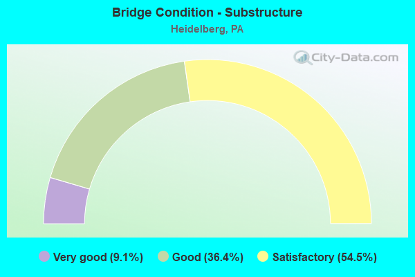
- Bridge Condition - Substructure
- 9.1%Very good
- 36.4%Good
- 54.5%Satisfactory
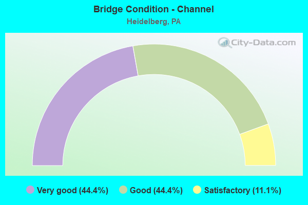
- Bridge Condition - Channel
- 44.4%Very good
- 44.4%Good
- 11.1%Satisfactory
Find on map >> Show street view
Structure Number: 698, Location: 300' S. THOMS RUN RD. (Lat: 40.380639, Lng: -80.095092), Route carried "on" structure: State highway 50, Year Built: 1978, Status: Open, Structure Length: 4.05m (13.29ft), Average Daily Traffic: 18,024 (year 2022), Truck Traffic: 5%, Average Future Daily Traffic: 18,221 (year 2032), Design Load: HS 20, Features Intersected: CHARTIERS CR FLOOD CHANN
Minimum Vertical Clearance: 30+ m (98+ ft), Kilometerpoint: 10.060, Lanes on structure: 4, Base Highway Network: Yes, Owner: State Highway Agency, Approaching Roadway Width: 15.8m (51.8ft), Skew: 1 degrees, Material/Design: Steel, Design/Construction: Stringer/Multi-beam, Number Of Spans In Main Unit: 1, Length of Maximum Span: 39.6m (129.9ft), Curb or Sidewalk Widths: Left: 1.5m (4.9ft), Right: 1.5m (4.9ft), Curb-To-Curb Width: 15.8m (51.8ft), Out-to-Out Width: 19.7m (64.6ft)
Condition: Deck: Good, Superstructure: Satisfactory, Substructure: Satisfactory, Channel: Very good, Inventory Rating: 66.2 metric tons, Method Used To Determine Inventory Rating: Load Factor (LF), Structural Evaluation: Equal to present minimum criteria, Deck Geometry: Meets minimum limits, Waterway Adequacy: Superior to present desirable criteria, Approach Roadway Alignment: Equal to present desirable criteria, Length Of Structure Improvement: 4.10m (13.45ft), Designated Inspection Frequency: Every 24 months, Inspection Date: October 2020, Bridge Improvement Cost: $14,000, Roadway Improvement Cost: $49,000, Total Project Cost: $187,000, Deck Structure Type: Concrete Cast-file-Place, Wearing Surface/Protective System: Wearing Surface: Monolithic Concrete
Find on map >> Show street view
Structure Number: 701, Location: HEIDELBERG-SCOTT TWP LINE (Lat: 40.394442, Lng: -80.087183), Route carried "on" structure: State highway 50, Year Built: 1965, Year Reconstructed: 1974, Status: Open, Structure Length: 11.19m (36.71ft), Average Daily Traffic: 7,420 (year 2022), Truck Traffic: 7%, Average Future Daily Traffic: 8,945 (year 2032), Design Load: HS 20, Features Intersected: CHARTIERS CREEK, Facility Carried by Structure: WASHINGTON AVE
Minimum Vertical Clearance: 30+ m (98+ ft), Kilometerpoint: 12.192, Lanes on structure: 2, Base Highway Network: Yes, Owner: State Highway Agency, Approaching Roadway Width: 9.1m (29.9ft), Skew: 3 degrees, Material/Design: Prestressed concrete, Design/Construction: Box Beam or Girders - Single/Spread, Number Of Spans In Main Unit: 6, Length of Maximum Span: 21.6m (70.9ft), Curb or Sidewalk Widths: Left: 0.6m (2.0ft), Right: 1.5m (4.9ft), Curb-To-Curb Width: 9.1m (29.9ft), Out-to-Out Width: 12.0m (39.4ft)
Condition: Deck: Good, Superstructure: Satisfactory, Substructure: Good, Channel: Satisfactory, Operating Rating: 69.9 metric tons, Method Used To Determine Operating Rating: Load Factor (LF), Inventory Rating: 41.7 metric tons, Method Used To Determine Inventory Rating: Load Factor (LF), Structural Evaluation: Equal to present minimum criteria, Deck Geometry: Meets minimum limits, Waterway Adequacy: Better than present minimum criteria, Approach Roadway Alignment: Equal to present desirable criteria, Length Of Structure Improvement: 11.50m (37.73ft), Designated Inspection Frequency: Every 24 months, Inspection Date: October 2020, Bridge Improvement Cost: $284,000, Roadway Improvement Cost: $836,000, Total Project Cost: $3,833,000, Deck Structure Type: Concrete Cast-file-Place, Wearing Surface/Protective System: Wearing Surface: Latex Concrete
Find on map >> Show street view
Structure Number: 704, Location: HEIDELBERG-SCOTT TWP LINE (Lat: 40.394394, Lng: -80.087336), Route carried "on" structure: State highway 50, Year Built: 1987, Status: Open, Structure Length: 10.58m (34.71ft), Average Daily Traffic: 7,420 (year 2022), Truck Traffic: 7%, Average Future Daily Traffic: 9,573 (year 2032), Design Load: HS 20, Features Intersected: CHARTIERS CREEK, Facility Carried by Structure: WASHINGTON AVE
Minimum Vertical Clearance: 30+ m (98+ ft), Kilometerpoint: 12.192, Lanes on structure: 2, Base Highway Network: Yes, Owner: State Highway Agency, Approaching Roadway Width: 11.0m (36.1ft), Skew: 4 degrees, Material/Design: Steel continuous, Design/Construction: Stringer/Multi-beam, Number Of Spans In Main Unit: 3, Length of Maximum Span: 44.5m (146.0ft), Curb or Sidewalk Widths: Left: 1.8m (5.9ft), Right: 0.2m (0.7ft), Curb-To-Curb Width: 8.5m (27.9ft), Out-to-Out Width: 11.4m (37.4ft)
Condition: Deck: Satisfactory, Superstructure: Good, Substructure: Good, Channel: Good, Operating Rating: 59.9 metric tons, Method Used To Determine Operating Rating: Load Factor (LF), Inventory Rating: 36.3 metric tons, Method Used To Determine Inventory Rating: Load Factor (LF), Structural Evaluation: Better than present minimum criteria, Deck Geometry: High priority of corrective action, Waterway Adequacy: Superior to present desirable criteria, Approach Roadway Alignment: Equal to present desirable criteria, Length Of Structure Improvement: 11.60m (38.06ft), Designated Inspection Frequency: Every 24 months, Inspection Date: October 2020, Bridge Improvement Cost: $262,000, Roadway Improvement Cost: $772,000, Total Project Cost: $3,539,000, Deck Structure Type: Concrete Cast-file-Place, Wearing Surface/Protective System: Wearing Surface: Epoxy Overlay, Deck Protection: Epoxy Coated Reinforcing
Find on map >> Show street view
Structure Number: 863, Location: 500' WEST OF SR 0050 (Lat: 40.380444, Lng: -80.097178), Route carried "on" structure: Interstate 79, Year Built: 1965, Year Reconstructed: 2005, Status: Open, Structure Length: 10.49m (34.42ft), Average Daily Traffic: 44,403 (year 2021), Truck Traffic: 20%, Average Future Daily Traffic: 32,252 (year 2032), Design Load: HS 20, Features Intersected: THOMS RUN RD,FLOOD CHANN, Facility Carried by Structure: RAYMOND P SHAFE HW
Minimum Vertical Clearance: 30+ m (98+ ft), Kilometerpoint: 7.854, Lanes on structure: 3, Lanes under structure: 2, Base Highway Network: Yes, Owner: State Highway Agency, Approaching Roadway Width: 17.1m (56.1ft), Skew: 12 degrees, Material/Design: Steel, Design/Construction: Stringer/Multi-beam, Number Of Spans In Main Unit: 3, Length of Maximum Span: 34.1m (111.9ft), Curb or Sidewalk Widths: Left: 0.2m (0.7ft), Right: 0.2m (0.7ft), Curb-To-Curb Width: 13.7m (44.9ft), Out-to-Out Width: 14.9m (48.9ft)
Condition: Deck: Satisfactory, Superstructure: Satisfactory, Substructure: Satisfactory, Channel: Very good, Operating Rating: 70.8 metric tons, Method Used To Determine Operating Rating: Load Factor (LF), Inventory Rating: 41.7 metric tons, Method Used To Determine Inventory Rating: Load Factor (LF), Structural Evaluation: Equal to present minimum criteria, Deck Geometry: Meets minimum limits, Underclear: Better than present minimum criteria, Waterway Adequacy: Superior to present desirable criteria, Approach Roadway Alignment: Equal to present desirable criteria, Length Of Structure Improvement: 10.50m (34.45ft), Designated Inspection Frequency: Every 24 months, Inspection Date: May 2020, Bridge Improvement Cost: $29,000, Roadway Improvement Cost: $86,000, Total Project Cost: $394,000, Deck Structure Type: Concrete Cast-file-Place, Wearing Surface/Protective System: Wearing Surface: Latex Concrete, Deck Protection: Epoxy Coated Reinforcing
Find on map >> Show street view
Structure Number: 864, Location: 0.7 MI. S.E. OF SR 3052 (Lat: 40.380564, Lng: -80.097506), Route carried "on" structure: Interstate 79, Year Built: 1965, Year Reconstructed: 2006, Status: Open, Structure Length: 12.65m (41.50ft), Average Daily Traffic: 43,560 (year 2021), Truck Traffic: 24%, Average Future Daily Traffic: 31,587 (year 2032), Design Load: HS 20, Features Intersected: THOMS RUN RD,FLOOD CHAN., Facility Carried by Structure: RAYMOND SHAFER HW
Minimum Vertical Clearance: 30+ m (98+ ft), Kilometerpoint: 7.894, Lanes on structure: 3, Lanes under structure: 2, Base Highway Network: Yes, Owner: State Highway Agency, Approaching Roadway Width: 14.6m (47.9ft), Skew: 12 degrees, Material/Design: Steel, Design/Construction: Stringer/Multi-beam, Number Of Spans In Main Unit: 3, Length of Maximum Span: 49.7m (163.1ft), Curb or Sidewalk Widths: Left: 0.2m (0.7ft), Right: 0.2m (0.7ft), Curb-To-Curb Width: 13.7m (44.9ft), Out-to-Out Width: 14.8m (48.6ft)
Condition: Deck: Good, Superstructure: Satisfactory, Substructure: Satisfactory, Channel: Very good, Operating Rating: 71.7 metric tons, Method Used To Determine Operating Rating: Load Factor (LF), Inventory Rating: 42.6 metric tons, Method Used To Determine Inventory Rating: Load Factor (LF), Structural Evaluation: Equal to present minimum criteria, Deck Geometry: Meets minimum limits, Underclear: Meets minimum limits, Waterway Adequacy: Superior to present desirable criteria, Approach Roadway Alignment: Equal to present desirable criteria, Length Of Structure Improvement: 12.50m (41.01ft), Designated Inspection Frequency: Every 24 months, Inspection Date: May 2020, Bridge Improvement Cost: $92,000, Roadway Improvement Cost: $271,000, Total Project Cost: $1,243,000, Deck Structure Type: Concrete Cast-file-Place, Wearing Surface/Protective System: Wearing Surface: Monolithic Concrete, Deck Protection: Epoxy Coated Reinforcing
Find on map >> Show street view
Structure Number: 1781, Location: 1/2 MI W OF US 0079 (Lat: 40.395825, Lng: -80.109644), Route carried "on" structure: State highway , Year Built: 1972, Year Reconstructed: 2008, Status: Open, Structure Length: 18.17m (59.61ft), Average Daily Traffic: 5,969 (year 2022), Truck Traffic: 9%, Average Future Daily Traffic: 6,526 (year 2032), Design Load: HS 20, Features Intersected: OHIO C.,SR3117,ROBINSON, Facility Carried by Structure: NOBLESTOWN RD
Minimum Vertical Clearance: 30+ m (98+ ft), Kilometerpoint: 9.688, Lanes on structure: 4, Lanes under structure: 2, Owner: State Highway Agency, Approaching Roadway Width: 19.5m (64.0ft), Skew: 29 degrees, Material/Design: Prestressed concrete, Design/Construction: Stringer/Multi-beam, Number Of Spans In Main Unit: 6, Length of Maximum Span: 34.4m (112.9ft), Curb or Sidewalk Widths: Left: 0.2m (0.7ft), Right: 0.2m (0.7ft), Curb-To-Curb Width: 18.7m (61.4ft), Out-to-Out Width: 20.0m (65.6ft)
Condition: Deck: Satisfactory, Superstructure: Fair, Substructure: Satisfactory, Channel: Good, Operating Rating: 66.2 metric tons, Method Used To Determine Operating Rating: Load Factor (LF), Inventory Rating: 24.5 metric tons, Method Used To Determine Inventory Rating: Load Factor (LF), Structural Evaluation: Somewhat better than minimum adequacy, Deck Geometry: Equal to present minimum criteria, Underclear: Superior to present desirable criteria, Waterway Adequacy: Superior to present desirable criteria, Approach Roadway Alignment: Equal to present desirable criteria, Length Of Structure Improvement: 18.20m (59.71ft), Designated Inspection Frequency: Every 24 months, Inspection Date: October 2020, Bridge Improvement Cost: $656,000, Roadway Improvement Cost: $1,931,000, Total Project Cost: $8,851,000, Deck Structure Type: Concrete Cast-file-Place, Wearing Surface/Protective System: Wearing Surface: Latex Concrete
Find on map >> Show street view
Structure Number: 1791, Location: 2 1/2 MI. S.OF RSLYN FRMS (Lat: 40.389706, Lng: -80.099333), Route carried "on" structure: State highway , Year Built: 1967, Status: Open, Structure Length: 8.99m (29.49ft), Average Daily Traffic: 3,649 (year 2022), Truck Traffic: 2%, Average Future Daily Traffic: 6,454 (year 2032), Design Load: HL 93, Features Intersected: SR 0079 NB-SB, Facility Carried by Structure: HILL TOP RD
Minimum Vertical Clearance: 30+ m (98+ ft), Kilometerpoint: 5.174, Lanes on structure: 2, Lanes under structure: 12, Owner: State Highway Agency, Approaching Roadway Width: 11.0m (36.1ft), Skew: 2 degrees, Material/Design: Prestressed concrete continuous, Design/Construction: Box Beam or Girders - Single/Spread, Number Of Spans In Main Unit: 3, Number Of Approach Spans: 1, Length of Maximum Span: 28.3m (92.8ft), Curb or Sidewalk Widths: Left: 0.2m (0.7ft), Right: 0.2m (0.7ft), Curb-To-Curb Width: 11.0m (36.1ft), Out-to-Out Width: 11.9m (39.0ft)
Condition: Deck: Good, Superstructure: Very good, Substructure: Good, Operating Rating: 51.5 metric tons, Method Used To Determine Operating Rating: Assigned ratings based on Load and Resistance Factor Design (LRFD) reported by rating factor (RF) using HL93 loadings, Inventory Rating: 32.4 metric tons, Method Used To Determine Inventory Rating: Assigned ratings based on Load and Resistance Factor Design (LRFD) reported by rating factor (RF) using HL93 loadings, Structural Evaluation: Better than present minimum criteria, Deck Geometry: Somewhat better than minimum adequacy, Underclear: Somewhat better than minimum adequacy, Approach Roadway Alignment: Equal to present desirable criteria, Length Of Structure Improvement: 8.80m (28.87ft), Designated Inspection Frequency: Every 24 months, Inspection Date: May 2021, Bridge Improvement Cost: $63,000, Roadway Improvement Cost: $186,000, Total Project Cost: $853,000, Deck Structure Type: Concrete Cast-file-Place, Wearing Surface/Protective System: Wearing Surface: Monolithic Concrete, Deck Protection: Epoxy Coated Reinforcing
Find on map >> Show street view
Structure Number: 1792, Location: AT INTERSECTION W/PA 50 (Lat: 40.387153, Lng: -80.090242), Route carried "on" structure: State highway , Year Built: 1960, Year Reconstructed: 2011, Status: Open, Structure Length: 7.01m (23.00ft), Average Daily Traffic: 22,379 (year 2022), Truck Traffic: 2%, Average Future Daily Traffic: 21,693 (year 2032), Design Load: HS 20, Features Intersected: CHARTIERS CREEK, Facility Carried by Structure: GREENTREE ROAD
Minimum Vertical Clearance: 30+ m (98+ ft), Kilometerpoint: 6.777, Lanes on structure: 4, Base Highway Network: Yes, Owner: State Highway Agency, Approaching Roadway Width: 18.9m (62.0ft), Skew: 33 degrees, Material/Design: Steel continuous, Design/Construction: Stringer/Multi-beam, Number Of Spans In Main Unit: 3, Length of Maximum Span: 27.4m (89.9ft), Curb or Sidewalk Widths: Left: 1.1m (3.6ft), Right: 0.2m (0.7ft), Curb-To-Curb Width: 16.2m (53.1ft), Out-to-Out Width: 18.7m (61.4ft)
Condition: Deck: Good, Superstructure: Satisfactory, Substructure: Satisfactory, Channel: Good, Operating Rating: 69.9 metric tons, Method Used To Determine Operating Rating: Load Factor (LF), Inventory Rating: 41.7 metric tons, Method Used To Determine Inventory Rating: Load Factor (LF), Structural Evaluation: Equal to present minimum criteria, Deck Geometry: Meets minimum limits, Waterway Adequacy: Equal to present minimum criteria, Approach Roadway Alignment: Equal to present desirable criteria, Length Of Structure Improvement: 7.00m (22.97ft), Designated Inspection Frequency: Every 24 months, Inspection Date: May 2021, Bridge Improvement Cost: $60,000, Roadway Improvement Cost: $176,000, Total Project Cost: $808,000, Deck Structure Type: Concrete Cast-file-Place, Wearing Surface/Protective System: Wearing Surface: Monolithic Concrete, Deck Protection: Epoxy Coated Reinforcing
Find on map >> Show street view
Structure Number: 431, Location: STEEN RD OVER I-79 (Lat: 40.377017, Lng: -80.100703), Route carried "on" structure: State highway , Year Built: 2005, Status: Open, Structure Length: 8.75m (28.71ft), Average Daily Traffic: 1,838 (year 2021), Truck Traffic: 13%, Average Future Daily Traffic: 5,266 (year 2032), Design Load: HL 93, Features Intersected: SR 0079 NB SB, Facility Carried by Structure: STEEN RD
Minimum Vertical Clearance: 30+ m (98+ ft), Kilometerpoint: 0.000, Lanes on structure: 2, Lanes under structure: 6, Owner: State Highway Agency, Approaching Roadway Width: 9.4m (30.8ft), Skew: 1 degrees, Material/Design: Prestressed concrete continuous, Design/Construction: Box Beam or Girders - Single/Spread, Number Of Spans In Main Unit: 4, Number Of Approach Spans: 1, Length of Maximum Span: 30.2m (99.1ft), Curb or Sidewalk Widths: Left: 0.2m (0.7ft), Right: 1.5m (4.9ft), Curb-To-Curb Width: 9.7m (31.8ft), Out-to-Out Width: 12.1m (39.7ft)
Condition: Deck: Good, Superstructure: Very good, Substructure: Good, Operating Rating: 49.2 metric tons, Method Used To Determine Operating Rating: Assigned ratings based on Load and Resistance Factor Design (LRFD) reported by rating factor (RF) using HL93 loadings, Inventory Rating: 38.2 metric tons, Method Used To Determine Inventory Rating: Assigned ratings based on Load and Resistance Factor Design (LRFD) reported by rating factor (RF) using HL93 loadings, Structural Evaluation: Better than present minimum criteria, Deck Geometry: Somewhat better than minimum adequacy, Underclear: Meets minimum limits, Approach Roadway Alignment: Better than present minimum criteria, Length Of Structure Improvement: 8.70m (28.54ft), Designated Inspection Frequency: Every 24 months, Inspection Date: May 2021, Deck Structure Type: Concrete Cast-file-Place, Wearing Surface/Protective System: Wearing Surface: Monolithic Concrete, Deck Protection: Epoxy Coated Reinforcing
Find on map >> Show street view
Structure Number: 45973, Location: .25 MI S. OF SR3048 (Lat: 40.393844, Lng: -80.111053), Route carried "on" structure: State highway , Year Built: 2010, Status: Open, Structure Length: 1.95m (6.40ft), Average Daily Traffic: 737 (year 2022), Truck Traffic: 5%, Average Future Daily Traffic: 742 (year 2032), Design Load: HS 20, Features Intersected: ROBINSON RUN, Facility Carried by Structure: DORRINGTON RD
Minimum Vertical Clearance: 30+ m (98+ ft), Kilometerpoint: 0.623, Lanes on structure: 2, Owner: State Highway Agency, Approaching Roadway Width: 9.8m (32.2ft), Skew: 2 degrees, Material/Design: Prestressed concrete, Design/Construction: Box Beam or Girders - Multiple, Number Of Spans In Main Unit: 1, Length of Maximum Span: 18.6m (61.0ft), Curb-To-Curb Width: 8.8m (28.9ft), Out-to-Out Width: 8.8m (28.9ft)
Condition: Deck: Very good, Superstructure: Very good, Substructure: Very good, Channel: Very good, Inventory Rating: 44.5 metric tons, Method Used To Determine Inventory Rating: Load Factor (LF), Structural Evaluation: Equal to present desirable criteria, Deck Geometry: Somewhat better than minimum adequacy, Waterway Adequacy: Better than present minimum criteria, Approach Roadway Alignment: Meets minimum limits, Designated Inspection Frequency: Every 24 months, Inspection Date: May 2021, Deck Structure Type: Concrete Cast-file-Place, Wearing Surface/Protective System: Wearing Surface: Monolithic Concrete, Deck Protection: Epoxy Coated Reinforcing
Find on map >> Show street view
Structure Number: 55976, Location: 1/2 MI W OF US 0079 (Lat: 40.395825, Lng: -80.109639), Route carried "on" structure: State highway , Year Built: 1972, Year Reconstructed: 2008, Status: Open, Structure Length: 18.17m (59.61ft), Average Daily Traffic: 3,062 (year 2022), Truck Traffic: 8%, Average Future Daily Traffic: 3,604 (year 2038), Design Load: HS 20, Features Intersected: OHIO C.,SR3117,ROBINSON, Facility Carried by Structure: NOBLESTOWN RD
Minimum Vertical Clearance: 30+ m (98+ ft), Kilometerpoint: 9.688, Lanes on structure: 4, Lanes under structure: 2, Owner: State Highway Agency, Approaching Roadway Width: 19.5m (64.0ft), Skew: 29 degrees, Material/Design: Prestressed concrete, Design/Construction: Stringer/Multi-beam, Number Of Spans In Main Unit: 6, Length of Maximum Span: 34.4m (112.9ft), Curb or Sidewalk Widths: Left: 0.2m (0.7ft), Right: 0.2m (0.7ft), Curb-To-Curb Width: 10.1m (33.1ft), Out-to-Out Width: 10.1m (33.1ft)
Condition: Deck: Satisfactory, Superstructure: Fair, Substructure: Satisfactory, Channel: Good, Operating Rating: 66.2 metric tons, Method Used To Determine Operating Rating: Load Factor (LF), Inventory Rating: 26.3 metric tons, Method Used To Determine Inventory Rating: Load Factor (LF), Structural Evaluation: Somewhat better than minimum adequacy, Deck Geometry: High priority of replacement, Underclear: Superior to present desirable criteria, Waterway Adequacy: Superior to present desirable criteria, Approach Roadway Alignment: Equal to present desirable criteria, Designated Inspection Frequency: Every 24 months, Inspection Date: October 2020, Deck Structure Type: Concrete Cast-file-Place, Wearing Surface/Protective System: Wearing Surface: Latex Concrete
Find on map >> Show street view
Structure Number: 863, Location: 500' WEST OF SR 0050 (Lat: 40.380444, Lng: -80.097178), Route carried "under" structure: County highway , Year Built: 1965, Structure Length: 0. m, Average Daily Traffic: 5,000 (year 2005), Truck Traffic: 1%, Features Intersected: THOMS RUN RD,FLOOD CHANN, Facility Carried by Structure: RAYMOND P SHAFE HW
Minimum Vertical Clearance: 4.72m (15.49ft), Kilometerpoint: 0.000, Lanes on structure: 3, Lanes under structure: 2, Material/Design: Steel, Design/Construction: Stringer/Multi-beam, Length of Maximum Span: 34.1m (111.9ft)
Find on map >> Show street view
Structure Number: 864, Location: 0.7 MI. S.E. OF SR 3052 (Lat: 40.380564, Lng: -80.097506), Route carried "under" structure: County highway , Year Built: 1965, Structure Length: 0. m, Average Daily Traffic: 4,900 (year 2005), Truck Traffic: 3%, Features Intersected: THOMS RUN RD,FLOOD CHAN., Facility Carried by Structure: RAYMOND SHAFER HW
Minimum Vertical Clearance: 4.90m (16.08ft), Kilometerpoint: 0.000, Lanes on structure: 3, Lanes under structure: 2, Material/Design: Steel, Design/Construction: Stringer/Multi-beam, Length of Maximum Span: 49.7m (163.1ft)
Find on map >> Show street view
Structure Number: 1781, Location: 1/2 MI W OF US 0079 (Lat: 40.395825, Lng: -80.109644), Route carried "under" structure: State highway , Year Built: 1972, Structure Length: 0. m, Average Daily Traffic: 737 (year 2022), Truck Traffic: 5%, Features Intersected: OHIO C.,SR3117,ROBINSON, Facility Carried by Structure: NOBLESTOWN RD
Minimum Vertical Clearance: 7.92m (25.98ft), Kilometerpoint: 0.623, Lanes on structure: 4, Lanes under structure: 2, Material/Design: Prestressed concrete, Design/Construction: Stringer/Multi-beam, Length of Maximum Span: 34.4m (112.9ft)
Find on map >> Show street view
Structure Number: 1791, Location: 2 1/2 MI. S.OF RSLYN FRMS (Lat: 40.389706, Lng: -80.099333), Route carried "under" structure: Interstate 79, Year Built: 1967, Structure Length: 0. m, Average Daily Traffic: 44,403 (year 2021), Truck Traffic: 20%, Features Intersected: SR 0079 NB-SB, Facility Carried by Structure: HILL TOP RD
Minimum Vertical Clearance: 5.18m (16.99ft), Kilometerpoint: 9.465, Lanes on structure: 2, Lanes under structure: 6, Material/Design: Prestressed concrete continuous, Design/Construction: Box Beam or Girders - Single/Spread, Length of Maximum Span: 28.3m (92.8ft)
Find on map >> Show street view
Structure Number: 1791, Location: 2 1/2 MI. S.OF RSLYN FRMS (Lat: 40.389706, Lng: -80.099333), Route carried "under" structure: Interstate 79, Year Built: 1967, Structure Length: 0. m, Average Daily Traffic: 43,560 (year 2021), Truck Traffic: 24%, Features Intersected: SR 0079 NB-SB, Facility Carried by Structure: HILL TOP RD
Minimum Vertical Clearance: 5.18m (16.99ft), Kilometerpoint: 9.465, Lanes on structure: 2, Lanes under structure: 6, Material/Design: Prestressed concrete continuous, Design/Construction: Box Beam or Girders - Single/Spread, Length of Maximum Span: 28.3m (92.8ft)
Find on map >> Show street view
Structure Number: 431, Location: STEEN RD OVER I-79 (Lat: 40.377017, Lng: -80.100703), Route carried "under" structure: Interstate 79, Year Built: 2005, Structure Length: 0. m, Average Daily Traffic: 43,560 (year 2021), Truck Traffic: 24%, Features Intersected: SR 0079 NB SB, Facility Carried by Structure: STEEN RD
Minimum Vertical Clearance: 5.51m (18.08ft), Kilometerpoint: 7.894, Lanes on structure: 2, Lanes under structure: 3, Material/Design: Prestressed concrete continuous, Design/Construction: Box Beam or Girders - Single/Spread, Length of Maximum Span: 30.2m (99.1ft)
Find on map >> Show street view
Structure Number: 431, Location: STEEN RD OVER I-79 (Lat: 40.377017, Lng: -80.100703), Route carried "under" structure: Interstate 79, Year Built: 2005, Structure Length: 0. m, Average Daily Traffic: 44,403 (year 2021), Truck Traffic: 20%, Features Intersected: SR 0079 NB SB, Facility Carried by Structure: STEEN RD
Minimum Vertical Clearance: 5.58m (18.31ft), Kilometerpoint: 7.854, Lanes on structure: 2, Lanes under structure: 3, Material/Design: Prestressed concrete continuous, Design/Construction: Box Beam or Girders - Single/Spread, Length of Maximum Span: 30.2m (99.1ft)