Bridge Statistics for Hico, Texas (TX)
Condition, Traffic, Stress, Structural Evaluation, Project Costs
- National Bridge Inventory (NBI) Statistics
- 22Number of bridges
- 220ft / 66.9mTotal length
- $7,176,000Total costs
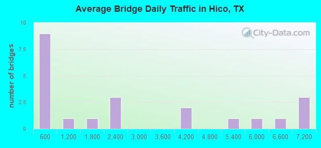
- 56,957Total average daily traffic
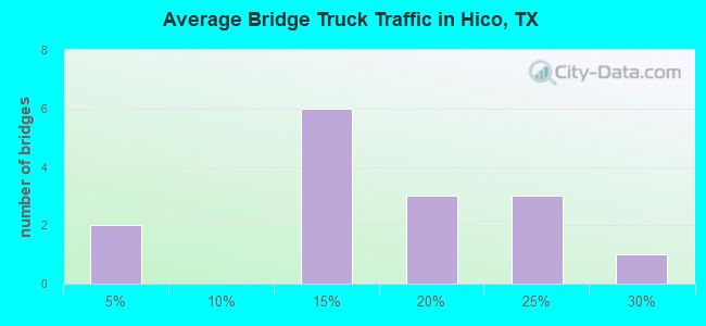
- 8,869Total average daily truck traffic
- National Bridge Inventory (NBI) Registered Bridges for Hico
- No street view available for this location
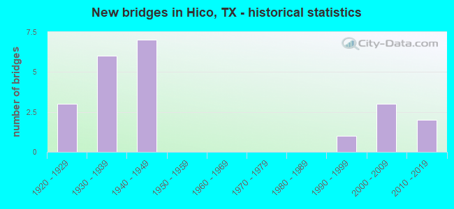
- New bridges - historical statistics
- 31920-1929
- 61930-1939
- 71940-1949
- 11990-1999
- 32000-2009
- 22010-2019
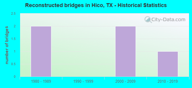
- Reconstructed bridges - Historical Statistics
- 21980-1989
- 01990-1999
- 22000-2009
- 12010-2019
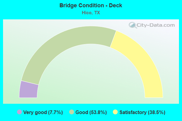
- Bridge Condition - Deck
- 7.7%Very good
- 53.8%Good
- 38.5%Satisfactory
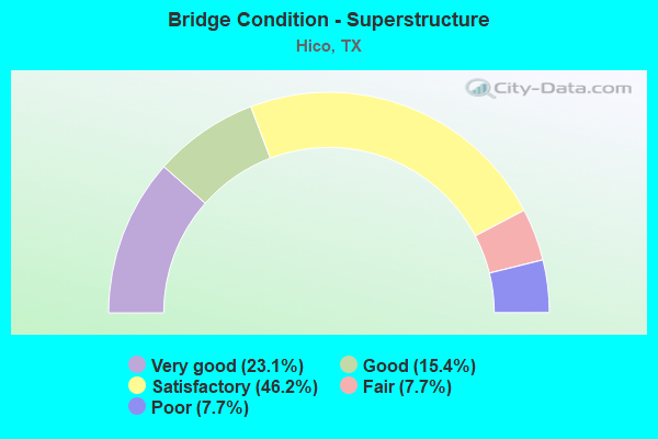
- Bridge Condition - Superstructure
- 23.1%Very good
- 15.4%Good
- 46.2%Satisfactory
- 7.7%Fair
- 7.7%Poor
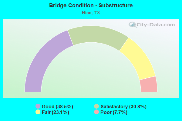
- Bridge Condition - Substructure
- 38.5%Good
- 30.8%Satisfactory
- 23.1%Fair
- 7.7%Poor
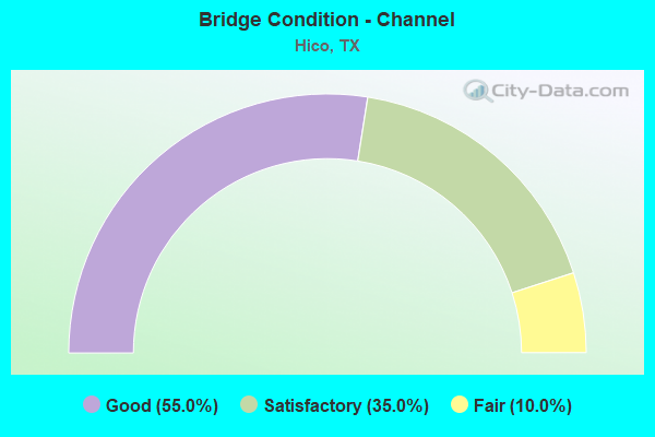
- Bridge Condition - Channel
- 55.0%Good
- 35.0%Satisfactory
- 10.0%Fair
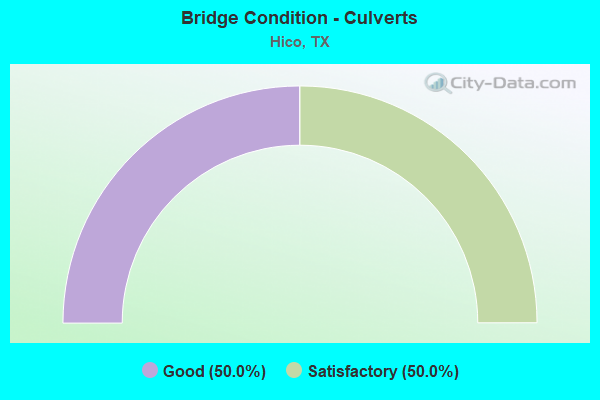
- Bridge Condition - Culverts
- 50.0%Good
- 50.0%Satisfactory
Find on map >> Show street view
Structure Number: 20730025004106, Location: 13.9 Mi. S. of US 67 (Lat: 32.031739, Lng: -98.082100), Route carried "on" structure: State highway 6, Year Built: 2015, Status: Open, Structure Length: 3.11m (10.20ft), Average Daily Traffic: 1,800 (year 2015), Truck Traffic: 26%, Average Future Daily Traffic: 8,540 (year 2035), Design Load: HL 93, Features Intersected: US 281 SB
Minimum Vertical Clearance: 30+ m (98+ ft), Kilometerpoint: 59.073, Lanes on structure: 1, Lanes under structure: 1, Base Highway Network: Yes, Owner: State Highway Agency, Approaching Roadway Width: 7.6m (24.9ft), Skew: 4 degrees, Material/Design: Prestressed concrete, Design/Construction: Stringer/Multi-beam, Number Of Spans In Main Unit: 1, Length of Maximum Span: 31.1m (102.0ft), Curb-To-Curb Width: 7.9m (25.9ft), Out-to-Out Width: 8.5m (27.9ft)
Condition: Deck: Very good, Superstructure: Very good, Substructure: Good, Operating Rating: 44.4 metric tons, Method Used To Determine Operating Rating: Assigned ratings based on Load and Resistance Factor Design (LRFD) reported in metric tons, Inventory Rating: 32.7 metric tons, Method Used To Determine Inventory Rating: Assigned ratings based on Load and Resistance Factor Design (LRFD) reported in metric tons, Structural Evaluation: Better than present minimum criteria, Deck Geometry: Meets minimum limits, Underclear: Meets minimum limits, Approach Roadway Alignment: Equal to present desirable criteria, Designated Inspection Frequency: Every 24 months, Inspection Date: August 2020, Deck Structure Type: Concrete Precast Panels
Find on map >> Show street view
Structure Number: 20730025802005, Location: 1.3 MI S OF JUNCTION SH 6 (Lat: 32.016158, Lng: -98.067017), Route carried "on" structure: US 281, Year Built: 1932, Year Reconstructed: 2018, Status: Open, Structure Length: 0.67m (2.20ft), Average Daily Traffic: 6,177 (year 2020), Truck Traffic: 19%, Average Future Daily Traffic: 7,470 (year 2033), Design Load: H 15, Features Intersected: MCKINNEY BRANCH
Minimum Vertical Clearance: 30+ m (98+ ft), Kilometerpoint: 61.084, Lanes on structure: 3, Base Highway Network: Yes, Owner: State Highway Agency, Approaching Roadway Width: 14.6m (47.9ft), Material/Design: Concrete, Design/Construction: Culvert, Number Of Spans In Main Unit: 2, Length of Maximum Span: 3.0m (9.8ft), Curb-To-Curb Width: 15.1m (49.5ft), Out-to-Out Width: 18.3m (60.0ft)
Condition: Channel: Good, Culverts: Good, Operating Rating: 39.9 metric tons, Method Used To Determine Operating Rating: Load Factor (LF), Inventory Rating: 23.6 metric tons, Method Used To Determine Inventory Rating: Load Factor (LF), Structural Evaluation: Somewhat better than minimum adequacy, Deck Geometry: Equal to present minimum criteria, Waterway Adequacy: Equal to present minimum criteria, Approach Roadway Alignment: Equal to present desirable criteria, Designated Inspection Frequency: Every 24 months, Inspection Date: August 2020, Deck Structure Type: Concrete Cast-file-Place, Wearing Surface/Protective System: Wearing Surface: Bituminous
Find on map >> Show street view
Structure Number: 20730046702002, Location: 0.8 MI S OF FM 2481 (Lat: 32.022322, Lng: -98.014917), Route carried "on" structure: State highway 220, Year Built: 1942, Status: Open, Structure Length: 0.73m (2.40ft), Average Daily Traffic: 2,395 (year 2020), Truck Traffic: 22%, Average Future Daily Traffic: 3,000 (year 2033), Design Load: H 15, Features Intersected: TRIB LTL DUFFAU CRK
Minimum Vertical Clearance: 30+ m (98+ ft), Kilometerpoint: 17.090, Lanes on structure: 2, Base Highway Network: Yes, Owner: State Highway Agency, Approaching Roadway Width: 10.4m (34.1ft), Skew: 3 degrees, Material/Design: Concrete, Design/Construction: Culvert, Number Of Spans In Main Unit: 3, Length of Maximum Span: 1.8m (5.9ft)
Condition: Channel: Satisfactory, Culverts: Good, Operating Rating: 39.9 metric tons, Method Used To Determine Operating Rating: Load Factor (LF), Inventory Rating: 23.6 metric tons, Method Used To Determine Inventory Rating: Load Factor (LF), Structural Evaluation: Equal to present minimum criteria, Waterway Adequacy: Equal to present minimum criteria, Approach Roadway Alignment: Equal to present desirable criteria, Designated Inspection Frequency: Every 24 months, Inspection Date: August 2020
Find on map >> Show street view
Structure Number: 20730046702003, Location: 0.2 MI S OF FM 2481 (Lat: 32.031931, Lng: -98.010442), Route carried "on" structure: State highway 220, Year Built: 1942, Status: Open, Structure Length: 3.20m (10.50ft), Average Daily Traffic: 2,395 (year 2020), Truck Traffic: 22%, Average Future Daily Traffic: 3,000 (year 2033), Design Load: H 15, Features Intersected: LITTLE DUFFAU CREEK
Minimum Vertical Clearance: 30+ m (98+ ft), Kilometerpoint: 15.924, Lanes on structure: 2, Base Highway Network: Yes, Owner: State Highway Agency, Approaching Roadway Width: 11.0m (36.1ft), Material/Design: Concrete, Design/Construction: Tee Beam, Number Of Spans In Main Unit: 3, Length of Maximum Span: 10.7m (35.1ft), Curb-To-Curb Width: 7.8m (25.6ft), Out-to-Out Width: 9.6m (31.5ft)
Condition: Deck: Satisfactory, Superstructure: Poor, Substructure: Fair, Channel: Good, Operating Rating: 48.1 metric tons, Method Used To Determine Operating Rating: Load Factor (LF), Inventory Rating: 29.0 metric tons, Method Used To Determine Inventory Rating: Load Factor (LF), Structural Evaluation: Meets minimum limits, Deck Geometry: High priority of replacement, Waterway Adequacy: Equal to present minimum criteria, Approach Roadway Alignment: Equal to present desirable criteria, Length Of Structure Improvement: 3.20m (10.50ft), Designated Inspection Frequency: Every 12 months, Inspection Date: August 2021, Bridge Improvement Cost: $5,000, Roadway Improvement Cost: $1,000, Total Project Cost: $6,000, Deck Structure Type: Concrete Cast-file-Place, Wearing Surface/Protective System: Wearing Surface: Bituminous
Find on map >> Show street view
Structure Number: 20730046702004, Location: 0.8 MI N OF FM 2481 (Lat: 32.045964, Lng: -98.003375), Route carried "on" structure: State highway 220, Year Built: 1942, Status: Open, Structure Length: 5.33m (17.49ft), Average Daily Traffic: 1,763 (year 2020), Truck Traffic: 15%, Average Future Daily Traffic: 2,640 (year 2033), Design Load: H 15, Features Intersected: DUFFAU CREEK
Minimum Vertical Clearance: 30+ m (98+ ft), Kilometerpoint: 14.209, Lanes on structure: 2, Base Highway Network: Yes, Owner: State Highway Agency, Approaching Roadway Width: 10.4m (34.1ft), Material/Design: Concrete, Design/Construction: Tee Beam, Number Of Spans In Main Unit: 5, Length of Maximum Span: 10.7m (35.1ft), Curb-To-Curb Width: 7.9m (25.9ft), Out-to-Out Width: 9.5m (31.2ft)
Condition: Deck: Good, Superstructure: Fair, Substructure: Satisfactory, Channel: Good, Operating Rating: 48.1 metric tons, Method Used To Determine Operating Rating: Load Factor (LF), Inventory Rating: 29.0 metric tons, Method Used To Determine Inventory Rating: Load Factor (LF), Structural Evaluation: Somewhat better than minimum adequacy, Deck Geometry: Meets minimum limits, Waterway Adequacy: Equal to present minimum criteria, Approach Roadway Alignment: Equal to present desirable criteria, Length Of Structure Improvement: 5.33m (17.49ft), Designated Inspection Frequency: Every 24 months, Inspection Date: August 2020, Bridge Improvement Cost: $9,000, Roadway Improvement Cost: $2,000, Total Project Cost: $11,000, Deck Structure Type: Concrete Cast-file-Place, Wearing Surface/Protective System: Wearing Surface: Bituminous
Find on map >> Show street view
Structure Number: 20730AA0218001, Location: 1.12 MI E OF SH 220 (Lat: 32.031589, Lng: -97.996553), Route carried "on" structure: County highway 218, Year Built: 1938, Status: Posted for load, Structure Length: 3.29m (10.79ft), Average Daily Traffic: 90 (year 2016), Average Future Daily Traffic: 140 (year 2036), Features Intersected: DUFFAU CREEK
Minimum Vertical Clearance: 30+ m (98+ ft), Kilometerpoint: 1.770, Lanes on structure: 1, Owner: County Highway Agency, Approaching Roadway Width: 4.3m (14.1ft), Material/Design: Steel, Design/Construction: Truss - Thru, Number Of Spans In Main Unit: 1, Number Of Approach Spans: 2, Length of Maximum Span: 21.0m (68.9ft), Curb-To-Curb Width: 3.5m (11.5ft), Out-to-Out Width: 3.7m (12.1ft)
Condition: Deck: Satisfactory, Superstructure: Satisfactory, Substructure: Satisfactory, Channel: Satisfactory, Operating Rating: 10.9 metric tons, Method Used To Determine Operating Rating: Allowable Stress (AS), Inventory Rating: 6.3 metric tons, Method Used To Determine Inventory Rating: Allowable Stress (AS), Structural Evaluation: High priority of replacement, Deck Geometry: High priority of corrective action, Waterway Adequacy: Better than present minimum criteria, Approach Roadway Alignment: Equal to present desirable criteria, Bridge Posting: Required (Relationship of Operating Rating to Maximum Legal Load: > 39.9% below), Length Of Structure Improvement: 4.11m (13.48ft), Designated Inspection Frequency: Every 24 months, Critical Feature Inspection Frequency: Every 24 months, Inspection Date: June 2020, Critical Feature Inspection Date: January 2020, Bridge Improvement Cost: $199,000, Roadway Improvement Cost: $36,000, Total Project Cost: $348,000, Deck Structure Type: Steel plate
Find on map >> Show street view
Structure Number: 20730AA0270003, Location: 3.5 MI S OF CLAIRETTE (Lat: 32.001619, Lng: -98.081786), Route carried "on" structure: County highway 270, Year Built: 1921, Status: Open, Structure Length: 4.82m (15.81ft), Average Daily Traffic: 70 (year 2016), Average Future Daily Traffic: 120 (year 2036), Features Intersected: NORTH BOSQUE RIVER
Minimum Vertical Clearance: 6.40m (21.00ft), Kilometerpoint: 8.369, Lanes on structure: 1, Owner: County Highway Agency, Approaching Roadway Width: 4.3m (14.1ft), Skew: 4 degrees, Material/Design: Steel, Design/Construction: Truss - Thru, Number Of Spans In Main Unit: 1, Length of Maximum Span: 48.2m (158.1ft), Curb-To-Curb Width: 4.3m (14.1ft), Out-to-Out Width: 4.9m (16.1ft)
Condition: Deck: Good, Superstructure: Satisfactory, Substructure: Fair, Channel: Satisfactory, Operating Rating: 32.7 metric tons, Method Used To Determine Operating Rating: Field evaluation and documented engineering judgment, Inventory Rating: 24.5 metric tons, Method Used To Determine Inventory Rating: Field evaluation and documented engineering judgment, Structural Evaluation: Somewhat better than minimum adequacy, Deck Geometry: Equal to present minimum criteria, Waterway Adequacy: Equal to present desirable criteria, Approach Roadway Alignment: Equal to present desirable criteria, Length Of Structure Improvement: 4.82m (15.81ft), Designated Inspection Frequency: Every 24 months, Critical Feature Inspection Frequency: Every 24 months, Inspection Date: June 2020, Critical Feature Inspection Date: June 2020, Total Project Cost: $44,000, Deck Structure Type: Concrete Cast-file-Place
Find on map >> Show street view
Structure Number: 90980025101041, Location: 0.4 MI S OF SH 6 (Lat: 31.977136, Lng: -98.035211), Route carried "on" structure: US 281, Year Built: 1942, Year Reconstructed: 2007, Status: Open, Structure Length: 21.64m (71.00ft), Average Daily Traffic: 6,992 (year 2019), Truck Traffic: 13%, Average Future Daily Traffic: 10,768 (year 2039), Design Load: HL 93, Features Intersected: BOSQUE RIVER
Minimum Vertical Clearance: 30+ m (98+ ft), Kilometerpoint: 0.555, Lanes on structure: 4, Base Highway Network: Yes, Owner: State Highway Agency, Approaching Roadway Width: 12.2m (40.0ft), Material/Design: Steel continuous, Design/Construction: Stringer/Multi-beam, Number Of Spans In Main Unit: 3, Number Of Approach Spans: 12, Length of Maximum Span: 27.4m (89.9ft), Curb or Sidewalk Widths: Left: 1.7m (5.6ft), Right: 1.6m (5.2ft), Curb-To-Curb Width: 19.2m (63.0ft), Out-to-Out Width: 23.2m (76.1ft)
Condition: Deck: Good, Superstructure: Good, Substructure: Satisfactory, Channel: Good, Operating Rating: 54.4 metric tons, Method Used To Determine Operating Rating: Assigned ratings based on Load and Resistance Factor Design (LRFD) reported in metric tons, Inventory Rating: 32.7 metric tons, Method Used To Determine Inventory Rating: Assigned ratings based on Load and Resistance Factor Design (LRFD) reported in metric tons, Structural Evaluation: Equal to present minimum criteria, Deck Geometry: Equal to present minimum criteria, Waterway Adequacy: Superior to present desirable criteria, Approach Roadway Alignment: Equal to present desirable criteria, Length Of Structure Improvement: 27.07m (88.81ft), Designated Inspection Frequency: Every 24 months, Inspection Date: January 2021, Bridge Improvement Cost: $2,800,000, Roadway Improvement Cost: $700,000, Total Project Cost: $4,200,000, Deck Structure Type: Corrugated Steel, Wearing Surface/Protective System: Wearing Surface: Monolithic Concrete
Find on map >> Show street view
Structure Number: 90980025101042, Location: 0.5 MI S OF SH 6 (Lat: 31.975211, Lng: -98.035692), Route carried "on" structure: US 281, Year Built: 1942, Year Reconstructed: 2007, Status: Open, Structure Length: 1.31m (4.30ft), Average Daily Traffic: 6,992 (year 2019), Truck Traffic: 14%, Average Future Daily Traffic: 10,768 (year 2039), Design Load: H 15, Features Intersected: BOSQUE RIVER RELIEF
Minimum Vertical Clearance: 30+ m (98+ ft), Kilometerpoint: 0.837, Lanes on structure: 3, Base Highway Network: Yes, Owner: State Highway Agency, Approaching Roadway Width: 20.1m (65.9ft), Material/Design: Concrete, Design/Construction: Culvert, Number Of Spans In Main Unit: 4, Length of Maximum Span: 3.0m (9.8ft), Curb or Sidewalk Widths: Left: 1.7m (5.6ft), Right: 0.0m
Condition: Channel: Good, Culverts: Satisfactory, Operating Rating: 39.9 metric tons, Method Used To Determine Operating Rating: Load Factor (LF), Inventory Rating: 23.6 metric tons, Method Used To Determine Inventory Rating: Load Factor (LF), Structural Evaluation: Somewhat better than minimum adequacy, Waterway Adequacy: Superior to present desirable criteria, Approach Roadway Alignment: Equal to present desirable criteria, Length Of Structure Improvement: 1.83m (6.00ft), Designated Inspection Frequency: Every 24 months, Inspection Date: January 2021, Bridge Improvement Cost: $200,000, Roadway Improvement Cost: $100,000, Total Project Cost: $400,000, Deck Structure Type: Concrete Cast-file-Place, Wearing Surface/Protective System: Wearing Surface: Bituminous
Find on map >> Show street view
Structure Number: 90980025803007, Location: 0.2 MI E OF SH 220 (Lat: 31.981511, Lng: -98.026064), Route carried "on" structure: State highway 6, Year Built: 1934, Year Reconstructed: 1985, Status: Open, Structure Length: 1.01m (3.31ft), Average Daily Traffic: 5,680 (year 2019), Truck Traffic: 14%, Average Future Daily Traffic: 8,861 (year 2039), Design Load: H 15, Features Intersected: JACK BRANCH
Minimum Vertical Clearance: 30+ m (98+ ft), Kilometerpoint: 3.912, Lanes on structure: 2, Base Highway Network: Yes, Owner: State Highway Agency, Approaching Roadway Width: 13.7m (44.9ft), Material/Design: Concrete, Design/Construction: Culvert, Number Of Spans In Main Unit: 3, Length of Maximum Span: 3.0m (9.8ft)
Condition: Channel: Good, Culverts: Satisfactory, Operating Rating: 39.9 metric tons, Method Used To Determine Operating Rating: Load Factor (LF), Inventory Rating: 23.6 metric tons, Method Used To Determine Inventory Rating: Load Factor (LF), Structural Evaluation: Somewhat better than minimum adequacy, Waterway Adequacy: Equal to present minimum criteria, Approach Roadway Alignment: Equal to present desirable criteria, Designated Inspection Frequency: Every 24 months, Inspection Date: January 2021
Find on map >> Show street view
Structure Number: 90980025803009, Location: 1.4 MI E OF SH 220 (Lat: 31.981503, Lng: -98.005722), Route carried "on" structure: State highway 6, Year Built: 1935, Year Reconstructed: 1985, Status: Open, Structure Length: 0.82m (2.69ft), Average Daily Traffic: 5,276 (year 2019), Truck Traffic: 13%, Average Future Daily Traffic: 7,703 (year 2039), Design Load: H 15, Features Intersected: TABOR BRANCH
Minimum Vertical Clearance: 30+ m (98+ ft), Kilometerpoint: 5.818, Lanes on structure: 2, Base Highway Network: Yes, Owner: State Highway Agency, Approaching Roadway Width: 12.8m (42.0ft), Material/Design: Concrete, Design/Construction: Culvert, Number Of Spans In Main Unit: 4, Length of Maximum Span: 1.8m (5.9ft)
Condition: Channel: Satisfactory, Culverts: Good, Operating Rating: 39.9 metric tons, Method Used To Determine Operating Rating: Load Factor (LF), Inventory Rating: 23.6 metric tons, Method Used To Determine Inventory Rating: Load Factor (LF), Structural Evaluation: Somewhat better than minimum adequacy, Waterway Adequacy: Equal to present minimum criteria, Approach Roadway Alignment: Equal to present desirable criteria, Length Of Structure Improvement: 0.91m (2.99ft), Designated Inspection Frequency: Every 24 months, Inspection Date: January 2021, Bridge Improvement Cost: $207,000, Roadway Improvement Cost: $82,000, Total Project Cost: $289,000
Find on map >> Show street view
Structure Number: 90980025803047, Location: 0.6 MI N OF SH 6 (Lat: 31.990181, Lng: -98.040314), Route carried "on" structure: US 281, Year Built: 1938, Status: Open, Structure Length: 1.22m (4.00ft), Average Daily Traffic: 6,963 (year 2019), Truck Traffic: 17%, Average Future Daily Traffic: 9,748 (year 2039), Design Load: H 15, Features Intersected: TRIB N BOSQUE RIVER
Minimum Vertical Clearance: 30+ m (98+ ft), Kilometerpoint: 65.405, Lanes on structure: 2, Base Highway Network: Yes, Owner: State Highway Agency, Approaching Roadway Width: 10.4m (34.1ft), Skew: 4 degrees, Material/Design: Concrete, Design/Construction: Culvert, Number Of Spans In Main Unit: 3, Length of Maximum Span: 2.4m (7.9ft), Curb-To-Curb Width: 10.4m (34.1ft), Out-to-Out Width: 11.1m (36.4ft)
Condition: Channel: Good, Culverts: Satisfactory, Operating Rating: 39.9 metric tons, Method Used To Determine Operating Rating: Load Factor (LF), Inventory Rating: 23.6 metric tons, Method Used To Determine Inventory Rating: Load Factor (LF), Structural Evaluation: Somewhat better than minimum adequacy, Deck Geometry: Meets minimum limits, Waterway Adequacy: Equal to present minimum criteria, Approach Roadway Alignment: Equal to present desirable criteria, Designated Inspection Frequency: Every 24 months, Inspection Date: January 2021, Deck Structure Type: Concrete Cast-file-Place, Wearing Surface/Protective System: Wearing Surface: Bituminous
Find on map >> Show street view
Structure Number: 90980046701001, Location: 0.3 MI N OF SH 6 (Lat: 31.986700, Lng: -98.027281), Route carried "on" structure: State highway 220, Year Built: 1942, Status: Open, Structure Length: 1.34m (4.40ft), Average Daily Traffic: 3,710 (year 2020), Truck Traffic: 11%, Average Future Daily Traffic: 5,238 (year 2039), Features Intersected: JACK HOLLOW CREEK
Minimum Vertical Clearance: 30+ m (98+ ft), Kilometerpoint: 2.832, Lanes on structure: 2, Owner: State Highway Agency, Approaching Roadway Width: 10.7m (35.1ft), Skew: 4 degrees, Material/Design: Concrete, Design/Construction: Culvert, Number Of Spans In Main Unit: 4, Length of Maximum Span: 2.1m (6.9ft), Curb-To-Curb Width: 11.0m (36.1ft), Out-to-Out Width: 13.6m (44.6ft)
Condition: Channel: Satisfactory, Culverts: Satisfactory, Operating Rating: 32.7 metric tons, Method Used To Determine Operating Rating: Field evaluation and documented engineering judgment, Inventory Rating: 24.5 metric tons, Method Used To Determine Inventory Rating: Field evaluation and documented engineering judgment, Structural Evaluation: Equal to present minimum criteria, Deck Geometry: Somewhat better than minimum adequacy, Waterway Adequacy: Equal to present minimum criteria, Approach Roadway Alignment: Equal to present desirable criteria, Designated Inspection Frequency: Every 24 months, Inspection Date: January 2021, Deck Structure Type: Concrete Cast-file-Place, Wearing Surface/Protective System: Wearing Surface: Bituminous
Find on map >> Show street view
Structure Number: 90980055006032, Location: 2.2 MI SE OF US 281 (Lat: 31.948333, Lng: -98.011322), Route carried "on" structure: State highway 1602, Year Built: 1993, Status: Open, Structure Length: 4.63m (15.19ft), Average Daily Traffic: 736 (year 2020), Truck Traffic: 13%, Average Future Daily Traffic: 1,023 (year 2039), Design Load: HS 20, Features Intersected: HONEY CREEK
Minimum Vertical Clearance: 30+ m (98+ ft), Kilometerpoint: 3.726, Lanes on structure: 2, Owner: State Highway Agency, Approaching Roadway Width: 9.1m (29.9ft), Material/Design: Concrete, Design/Construction: Stringer/Multi-beam, Number Of Spans In Main Unit: 5, Length of Maximum Span: 9.1m (29.9ft), Curb-To-Curb Width: 9.1m (29.9ft), Out-to-Out Width: 9.8m (32.2ft)
Condition: Deck: Good, Superstructure: Good, Substructure: Good, Channel: Fair, Operating Rating: 54.4 metric tons, Method Used To Determine Operating Rating: Load Factor (LF), Inventory Rating: 32.7 metric tons, Method Used To Determine Inventory Rating: Load Factor (LF), Structural Evaluation: Better than present minimum criteria, Deck Geometry: Equal to present minimum criteria, Waterway Adequacy: Equal to present desirable criteria, Approach Roadway Alignment: Equal to present desirable criteria, Designated Inspection Frequency: Every 24 months, Inspection Date: January 2021, Deck Structure Type: Concrete Cast-file-Place
Find on map >> Show street view
Structure Number: 90980AA0260002, Location: 1.35 MI W OF US 281 (Lat: 31.979186, Lng: -98.057900), Route carried "on" structure: County highway 133, Year Built: 2003, Status: Open, Structure Length: 1.98m (6.50ft), Average Daily Traffic: 115 (year 2016), Average Future Daily Traffic: 130 (year 2036), Design Load: HS 20, Features Intersected: N BOSQUE RIV TRIB # 217
Minimum Vertical Clearance: 30+ m (98+ ft), Kilometerpoint: 4.506, Lanes on structure: 2, Owner: County Highway Agency, Approaching Roadway Width: 7.9m (25.9ft), Material/Design: Prestressed concrete, Design/Construction: Stringer/Multi-beam, Number Of Spans In Main Unit: 1, Length of Maximum Span: 19.8m (65.0ft), Curb-To-Curb Width: 7.3m (24.0ft), Out-to-Out Width: 7.9m (25.9ft)
Condition: Deck: Good, Superstructure: Very good, Substructure: Good, Channel: Good, Operating Rating: 54.4 metric tons, Method Used To Determine Operating Rating: Assigned rating based on Load Factor Design (LFD) reported in metric tons, Inventory Rating: 32.7 metric tons, Method Used To Determine Inventory Rating: Assigned rating based on Load Factor Design (LFD) reported in metric tons, Structural Evaluation: Better than present minimum criteria, Deck Geometry: Somewhat better than minimum adequacy, Waterway Adequacy: Superior to present desirable criteria, Approach Roadway Alignment: Equal to present desirable criteria, Designated Inspection Frequency: Every 24 months, Inspection Date: March 2020, Deck Structure Type: Concrete Precast Panels
Find on map >> Show street view
Structure Number: 90980AA0260003, Location: 0.50 MI W OF US 281 (Lat: 31.974442, Lng: -98.044564), Route carried "on" structure: County highway 133, Year Built: 2003, Status: Open, Structure Length: 1.83m (6.00ft), Average Daily Traffic: 35 (year 2016), Average Future Daily Traffic: 50 (year 2036), Design Load: HS 20, Features Intersected: N BOSQUE RIV TRIB # 218
Minimum Vertical Clearance: 30+ m (98+ ft), Kilometerpoint: 5.794, Lanes on structure: 2, Owner: County Highway Agency, Approaching Roadway Width: 7.9m (25.9ft), Skew: 3 degrees, Material/Design: Prestressed concrete, Design/Construction: Stringer/Multi-beam, Number Of Spans In Main Unit: 1, Length of Maximum Span: 18.3m (60.0ft), Curb-To-Curb Width: 7.3m (24.0ft), Out-to-Out Width: 7.9m (25.9ft)
Condition: Deck: Good, Superstructure: Very good, Substructure: Good, Channel: Good, Operating Rating: 54.4 metric tons, Method Used To Determine Operating Rating: Assigned rating based on Load Factor Design (LFD) reported in metric tons, Inventory Rating: 32.7 metric tons, Method Used To Determine Inventory Rating: Assigned rating based on Load Factor Design (LFD) reported in metric tons, Structural Evaluation: Better than present minimum criteria, Deck Geometry: Equal to present minimum criteria, Waterway Adequacy: Superior to present desirable criteria, Approach Roadway Alignment: Better than present minimum criteria, Designated Inspection Frequency: Every 24 months, Inspection Date: March 2020, Total Project Cost: $208,000, Deck Structure Type: Concrete Precast Panels
Find on map >> Show street view
Structure Number: 90980C00015001, Location: 0.25 MI W OF US 281 (Lat: 31.982872, Lng: -98.038117), Route carried "on" structure: City street , Year Built: 2007, Status: Open, Structure Length: 1.89m (6.20ft), Average Daily Traffic: 340 (year 2016), Average Future Daily Traffic: 360 (year 2036), Design Load: HS 20, Features Intersected: GRUBBS BR #4 HIC, Facility Carried by Structure: FIRST ST
Minimum Vertical Clearance: 30+ m (98+ ft), Kilometerpoint: 0.402, Lanes on structure: 2, Owner: City or Municipal Highway Agency, Approaching Roadway Width: 7.3m (24.0ft), Skew: 3 degrees, Material/Design: Concrete, Design/Construction: Culvert, Number Of Spans In Main Unit: 5, Length of Maximum Span: 3.7m (12.1ft), Curb-To-Curb Width: 8.4m (27.6ft), Out-to-Out Width: 8.9m (29.2ft)
Condition: Channel: Good, Culverts: Good, Operating Rating: 54.4 metric tons, Method Used To Determine Operating Rating: Assigned rating based on Load Factor Design (LFD) reported in metric tons, Inventory Rating: 32.7 metric tons, Method Used To Determine Inventory Rating: Assigned rating based on Load Factor Design (LFD) reported in metric tons, Structural Evaluation: Better than present minimum criteria, Deck Geometry: Somewhat better than minimum adequacy, Waterway Adequacy: Superior to present desirable criteria, Approach Roadway Alignment: Equal to present desirable criteria, Length Of Structure Improvement: 2.74m (8.99ft), Designated Inspection Frequency: Every 24 months, Inspection Date: March 2020, Bridge Improvement Cost: $251,000, Roadway Improvement Cost: $62,000, Total Project Cost: $313,000, Deck Structure Type: Concrete Cast-file-Place, Wearing Surface/Protective System: Wearing Surface: Bituminous
Find on map >> Show street view
Structure Number: 90980C00115001, Location: 0.35 MI S OF SH 6 (Lat: 31.976975, Lng: -98.033081), Route carried "on" structure: City street , Year Built: 1920, Status: Posted for load, Structure Length: 3.44m (11.29ft), Average Daily Traffic: 550 (year 2016), Truck Traffic: 1%, Average Future Daily Traffic: 560 (year 2036), Features Intersected: N BOSQUE RIVER #2 HIC, Facility Carried by Structure: ELM ST
Minimum Vertical Clearance: 30+ m (98+ ft), Kilometerpoint: 0.805, Lanes on structure: 1, Owner: City or Municipal Highway Agency, Approaching Roadway Width: 5.8m (19.0ft), Material/Design: Steel, Design/Construction: Truss - Thru, Number Of Spans In Main Unit: 1, Number Of Approach Spans: 2, Length of Maximum Span: 25.0m (82.0ft), Curb or Sidewalk Widths: Left: 1.0m (3.3ft), Right: 0.0m, Curb-To-Curb Width: 5.7m (18.7ft), Out-to-Out Width: 5.7m (18.7ft)
Condition: Deck: Satisfactory, Superstructure: Satisfactory, Substructure: Fair, Channel: Satisfactory, Operating Rating: 12.7 metric tons, Method Used To Determine Operating Rating: Allowable Stress (AS), Inventory Rating: 8.2 metric tons, Method Used To Determine Inventory Rating: Allowable Stress (AS), Structural Evaluation: High priority of replacement, Deck Geometry: High priority of replacement, Waterway Adequacy: Better than present minimum criteria, Approach Roadway Alignment: Equal to present minimum criteria, Bridge Posting: Required (Relationship of Operating Rating to Maximum Legal Load: > 39.9% below), Length Of Structure Improvement: 4.57m (14.99ft), Designated Inspection Frequency: Every 24 months, Critical Feature Inspection Frequency: Every 24 months, Inspection Date: March 2020, Critical Feature Inspection Date: March 2021, Bridge Improvement Cost: $419,000, Roadway Improvement Cost: $104,000, Total Project Cost: $523,000, Deck Structure Type: Concrete Cast-file-Place
Find on map >> Show street view
Structure Number: 90980C00115002, Location: 0.50 MI S OF SH 6 (Lat: 31.974911, Lng: -98.031842), Route carried "on" structure: City street , Year Built: 1920, Status: Posted for load, Structure Length: 2.80m (9.19ft), Average Daily Traffic: 270 (year 2013), Average Future Daily Traffic: 350 (year 2035), Features Intersected: N BOSQUE RI REL #1 HIC, Facility Carried by Structure: ELM ST
Minimum Vertical Clearance: 30+ m (98+ ft), Kilometerpoint: 1.046, Lanes on structure: 1, Owner: City or Municipal Highway Agency, Approaching Roadway Width: 4.9m (16.1ft), Material/Design: Steel, Design/Construction: Stringer/Multi-beam, Number Of Spans In Main Unit: 3, Length of Maximum Span: 9.1m (29.9ft), Curb-To-Curb Width: 5.2m (17.1ft), Out-to-Out Width: 5.5m (18.0ft)
Condition: Deck: Satisfactory, Superstructure: Satisfactory, Substructure: Satisfactory, Channel: Good, Operating Rating: 38.1 metric tons, Method Used To Determine Operating Rating: Allowable Stress (AS), Inventory Rating: 25.4 metric tons, Method Used To Determine Inventory Rating: Allowable Stress (AS), Structural Evaluation: Equal to present minimum criteria, Deck Geometry: High priority of replacement, Waterway Adequacy: Equal to present minimum criteria, Approach Roadway Alignment: Equal to present desirable criteria, Bridge Posting: Required (Relationship of Operating Rating to Maximum Legal Load: 0.1 - 9.9% below), Length Of Structure Improvement: 3.66m (12.01ft), Designated Inspection Frequency: Every 24 months, Inspection Date: March 2020, Bridge Improvement Cost: $334,000, Roadway Improvement Cost: $84,000, Total Project Cost: $418,000, Deck Structure Type: Wood or Timber, Wearing Surface/Protective System: Wearing Surface: Bituminous
Find on map >> Show street view
Structure Number: 90980C00155001, Location: 0.10 MI E OF SH 220 (Lat: 31.984236, Lng: -98.026397), Route carried "on" structure: City street , Year Built: 1931, Status: Posted for load, Structure Length: 1.04m (3.41ft), Average Daily Traffic: 468 (year 2013), Average Future Daily Traffic: 500 (year 2035), Features Intersected: JACKS HOLLOW CRK #3 HIC, Facility Carried by Structure: IREDELL ST
Minimum Vertical Clearance: 30+ m (98+ ft), Kilometerpoint: 0.161, Lanes on structure: 1, Owner: City or Municipal Highway Agency, Approaching Roadway Width: 5.2m (17.1ft), Skew: 1 degrees, Material/Design: Steel continuous, Design/Construction: Stringer/Multi-beam, Number Of Spans In Main Unit: 2, Length of Maximum Span: 5.2m (17.1ft), Curb-To-Curb Width: 5.2m (17.1ft), Out-to-Out Width: 5.2m (17.1ft)
Condition: Deck: Good, Superstructure: Satisfactory, Substructure: Poor, Channel: Fair, Operating Rating: 32.7 metric tons, Method Used To Determine Operating Rating: Field evaluation and documented engineering judgment, Inventory Rating: 24.5 metric tons, Method Used To Determine Inventory Rating: Field evaluation and documented engineering judgment, Structural Evaluation: Meets minimum limits, Deck Geometry: High priority of replacement, Waterway Adequacy: Better than present minimum criteria, Approach Roadway Alignment: Equal to present desirable criteria, Length Of Structure Improvement: 1.83m (6.00ft), Designated Inspection Frequency: Every 24 months, Critical Feature Inspection Frequency: Every 24 months, Inspection Date: March 2020, Critical Feature Inspection Date: March 2021, Bridge Improvement Cost: $167,000, Roadway Improvement Cost: $41,000, Total Project Cost: $208,000, Deck Structure Type: Concrete Cast-file-Place
Find on map >> Show street view
Structure Number: 90980C00203001, Location: 0.25 MI W OF US 281 (Lat: 31.981614, Lng: -98.037958), Route carried "on" structure: City street , Year Built: 1940, Status: Open, Structure Length: 0.82m (2.69ft), Average Daily Traffic: 440 (year 2016), Truck Traffic: 1%, Average Future Daily Traffic: 440 (year 2036), Features Intersected: GRUBBS BR #5 HIC, Facility Carried by Structure: RAILROAD AVE
Minimum Vertical Clearance: 30+ m (98+ ft), Kilometerpoint: 0.402, Lanes on structure: 2, Owner: City or Municipal Highway Agency, Approaching Roadway Width: 6.1m (20.0ft), Skew: 1 degrees, Material/Design: Steel, Design/Construction: Stringer/Multi-beam, Number Of Spans In Main Unit: 1, Length of Maximum Span: 7.0m (23.0ft), Curb-To-Curb Width: 6.1m (20.0ft), Out-to-Out Width: 6.4m (21.0ft)
Condition: Deck: Satisfactory, Superstructure: Satisfactory, Substructure: Good, Channel: Satisfactory, Operating Rating: 68.0 metric tons, Method Used To Determine Operating Rating: Allowable Stress (AS), Inventory Rating: 40.8 metric tons, Method Used To Determine Inventory Rating: Allowable Stress (AS), Structural Evaluation: Equal to present minimum criteria, Deck Geometry: High priority of corrective action, Waterway Adequacy: Better than present minimum criteria, Approach Roadway Alignment: Equal to present desirable criteria, Length Of Structure Improvement: 1.83m (6.00ft), Designated Inspection Frequency: Every 24 months, Inspection Date: March 2020, Bridge Improvement Cost: $167,000, Roadway Improvement Cost: $41,000, Total Project Cost: $208,000, Deck Structure Type: Concrete Cast-file-Place
Find on map >> Show street view
Structure Number: 20730025004106, Location: 13.9 Mi. S. of US 67 (Lat: 32.031739, Lng: -98.082100), Route carried "under" structure: US 281, Year Built: 2015, Structure Length: 0. m, Average Daily Traffic: 3,700 (year 2015), Truck Traffic: 23%, Features Intersected: US 281 SB, Facility Carried by Structure: SH 6 WB
Minimum Vertical Clearance: 5.52m (18.11ft), Kilometerpoint: 59.031, Lanes on structure: 1, Lanes under structure: 1, Material/Design: Prestressed concrete, Design/Construction: Stringer/Multi-beam, Length of Maximum Span: 31.1m (102.0ft)