Bridge Statistics for Hooven, Ohio (OH)
Condition, Traffic, Stress, Structural Evaluation, Project Costs
- National Bridge Inventory (NBI) Statistics
- 12Number of bridges
- 289ft / 88.3mTotal length
- $750,000Total costs
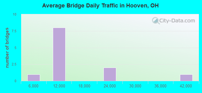
- 145,403Total average daily traffic
- 16,681Total average daily truck traffic
- National Bridge Inventory (NBI) Registered Bridges for Hooven
- No street view available for this location
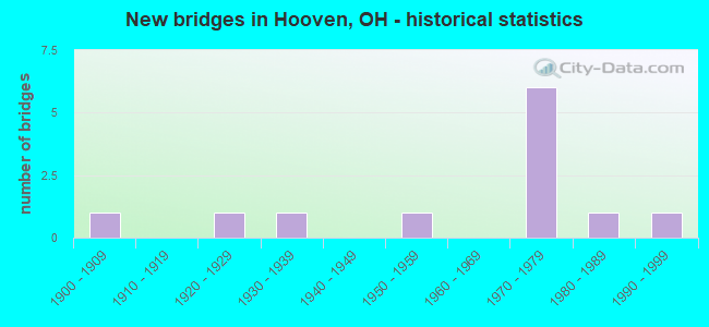
- New bridges - historical statistics
- 11900-1909
- 11920-1929
- 11930-1939
- 11950-1959
- 61970-1979
- 11980-1989
- 11990-1999
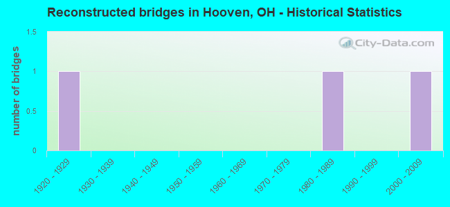
- Reconstructed bridges - Historical Statistics
- 11920-1929
- 01930-1939
- 01940-1949
- 01950-1959
- 01960-1969
- 01970-1979
- 11980-1989
- 01990-1999
- 12000-2009
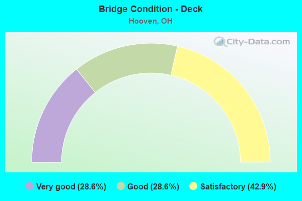
- Bridge Condition - Deck
- 28.6%Very good
- 28.6%Good
- 42.9%Satisfactory
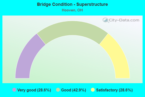
- Bridge Condition - Superstructure
- 28.6%Very good
- 42.9%Good
- 28.6%Satisfactory
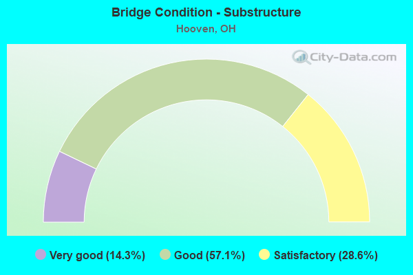
- Bridge Condition - Substructure
- 14.3%Very good
- 57.1%Good
- 28.6%Satisfactory
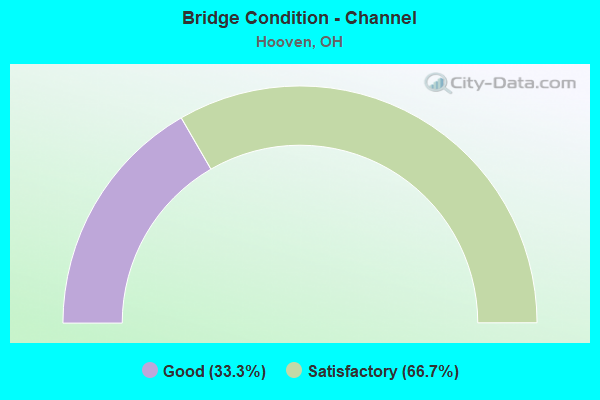
- Bridge Condition - Channel
- 33.3%Good
- 66.7%Satisfactory
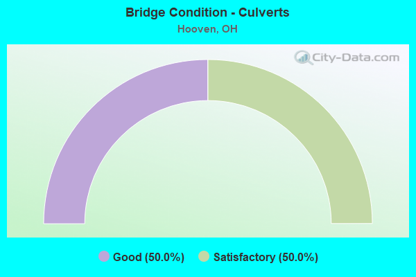
- Bridge Condition - Culverts
- 50.0%Good
- 50.0%Satisfactory
Find on map >> Show street view
Structure Number: 3102521, Location: JUST E OF SR128 (Lat: 39.170400, Lng: -84.759050), Route carried "on" structure: US 50, Year Built: 1959, Status: Open, Structure Length: 27.22m (89.30ft), Average Daily Traffic: 9,907 (year 2015), Truck Traffic: 7%, Average Future Daily Traffic: 13,751 (year 2035), Design Load: HS 20, Features Intersected: GREAT MIAMI R;PRIVATE DR
Minimum Vertical Clearance: 5.66m (18.57ft), Kilometerpoint: 6.051, Lanes on structure: 2, Base Highway Network: Yes, Owner: State Highway Agency, Approaching Roadway Width: 7.3m (24.0ft), Material/Design: Steel, Design/Construction: Truss - Thru, Number Of Spans In Main Unit: 4, Length of Maximum Span: 75.6m (248.0ft), Curb-To-Curb Width: 9.8m (32.2ft), Out-to-Out Width: 12.4m (40.7ft)
Condition: Deck: Good, Superstructure: Satisfactory, Substructure: Satisfactory, Channel: Good, Operating Rating: 38.9 metric tons, Method Used To Determine Operating Rating: Load Factor (LF) rating reported by rating factor (RF) method using MS18 loading, Inventory Rating: 25.9 metric tons, Method Used To Determine Inventory Rating: Load Factor (LF) rating reported by rating factor (RF) method using MS18 loading, Structural Evaluation: Equal to present minimum criteria, Deck Geometry: Meets minimum limits, Waterway Adequacy: Superior to present desirable criteria, Approach Roadway Alignment: Equal to present desirable criteria, Length Of Structure Improvement: 27.22m (89.30ft), Designated Inspection Frequency: Every 12 months, Critical Feature Inspection Frequency: Every 24 months, Underwater Inspection Frequency: Every 60 months, Inspection Date: July 2021, Critical Feature Inspection Date: August 2020, Underwater Inspection Date: August 2019, Bridge Improvement Cost: $680,000, Roadway Improvement Cost: $70,000, Total Project Cost: $750,000, Deck Structure Type: Concrete Cast-file-Place, Wearing Surface/Protective System: Wearing Surface: Monolithic Concrete, Deck Protection: Epoxy Coated Reinforcing
Find on map >> Show street view
Structure Number: 3102548, Location: 0.03 MI. E. OF SR 128 (Lat: 39.170239, Lng: -84.759139), Route carried "on" structure: US 50, Year Built: 1991, Status: Open, Structure Length: 26.33m (86.38ft), Average Daily Traffic: 9,907 (year 2015), Truck Traffic: 7%, Average Future Daily Traffic: 13,751 (year 2035), Design Load: HS 20+Mod, Features Intersected: GREAT MIAMI RIVER
Minimum Vertical Clearance: 30+ m (98+ ft), Kilometerpoint: 6.051, Lanes on structure: 2, Base Highway Network: Yes, Owner: State Highway Agency, Approaching Roadway Width: 8.5m (27.9ft), Material/Design: Steel continuous, Design/Construction: Stringer/Multi-beam, Number Of Spans In Main Unit: 6, Length of Maximum Span: 50.6m (166.0ft), Curb or Sidewalk Widths: Left: 0.0m, Right: 1.5m (4.9ft), Curb-To-Curb Width: 9.4m (30.8ft), Out-to-Out Width: 11.8m (38.7ft)
Condition: Deck: Good, Superstructure: Very good, Substructure: Good, Channel: Satisfactory, Operating Rating: 51.8 metric tons, Method Used To Determine Operating Rating: Load and Resistance Factor Rating (LRFR) rating reported by rating factor(RF) method using HL-93 loadings, Inventory Rating: 42.1 metric tons, Method Used To Determine Inventory Rating: Load and Resistance Factor Rating (LRFR) rating reported by rating factor(RF) method using HL-93 loadings, Structural Evaluation: Better than present minimum criteria, Deck Geometry: Meets minimum limits, Waterway Adequacy: Superior to present desirable criteria, Approach Roadway Alignment: Superior to present desirable criteria, Designated Inspection Frequency: Every 24 months, Underwater Inspection Frequency: Every 60 months, Inspection Date: July 2021, Underwater Inspection Date: August 2019, Deck Structure Type: Concrete Cast-file-Place, Wearing Surface/Protective System: Wearing Surface: Monolithic Concrete, Deck Protection: Epoxy Coated Reinforcing
Find on map >> Show street view
Structure Number: 310423, Location: 2.17 MI NO OF US-50 (Lat: 39.200700, Lng: -84.755289), Route carried "on" structure: State highway 128, Year Built: 1900, Year Reconstructed: 1932, Status: Open, Structure Length: 0.76m (2.49ft), Average Daily Traffic: 8,966 (year 2018), Truck Traffic: 8%, Average Future Daily Traffic: 12,445 (year 2038), Design Load: H 15, Features Intersected: TRIB GREAT MIAMI RIVER
Minimum Vertical Clearance: 30+ m (98+ ft), Kilometerpoint: 3.492, Lanes on structure: 2, Owner: State Highway Agency, Approaching Roadway Width: 6.7m (22.0ft), Material/Design: Concrete, Design/Construction: Culvert, Number Of Spans In Main Unit: 1, Length of Maximum Span: 5.8m (19.0ft)
Condition: Channel: Satisfactory, Culverts: Good, Operating Rating: 42.1 metric tons, Method Used To Determine Operating Rating: Load Factor (LF) rating reported by rating factor (RF) method using MS18 loading, Inventory Rating: 32.4 metric tons, Method Used To Determine Inventory Rating: Load Factor (LF) rating reported by rating factor (RF) method using MS18 loading, Structural Evaluation: Better than present minimum criteria, Waterway Adequacy: Better than present minimum criteria, Approach Roadway Alignment: Equal to present desirable criteria, Designated Inspection Frequency: Every 24 months, Inspection Date: April 2021
Find on map >> Show street view
Structure Number: 3116107, Location: 3.9 MI E OF IND-OH LINE (Lat: 39.186300, Lng: -84.778539), Route carried "on" structure: Interstate 275, Year Built: 1975, Status: Open, Structure Length: 7.74m (25.39ft), Average Daily Traffic: 18,680 (year 2015), Truck Traffic: 14%, Average Future Daily Traffic: 25,928 (year 2035), Design Load: HS 20+Mod, Features Intersected: CR 13(KILBY ROAD); NSRR
Minimum Vertical Clearance: 30+ m (98+ ft), Kilometerpoint: 6.389, Lanes on structure: 2, Lanes under structure: 4, Base Highway Network: Yes, Owner: State Highway Agency, Approaching Roadway Width: 16.5m (54.1ft), Skew: 2 degrees, Material/Design: Steel continuous, Design/Construction: Stringer/Multi-beam, Number Of Spans In Main Unit: 5, Length of Maximum Span: 18.0m (59.1ft), Curb-To-Curb Width: 15.2m (49.9ft), Out-to-Out Width: 15.9m (52.2ft)
Condition: Deck: Satisfactory, Superstructure: Good, Substructure: Good, Operating Rating: 42.1 metric tons, Method Used To Determine Operating Rating: Load Factor (LF) rating reported by rating factor (RF) method using MS18 loading, Inventory Rating: 32.4 metric tons, Method Used To Determine Inventory Rating: Load Factor (LF) rating reported by rating factor (RF) method using MS18 loading, Structural Evaluation: Better than present minimum criteria, Deck Geometry: Superior to present desirable criteria, Underclear: Superior to present desirable criteria, Approach Roadway Alignment: Superior to present desirable criteria, Designated Inspection Frequency: Every 12 months, Inspection Date: January 2021, Deck Structure Type: Concrete Cast-file-Place, Wearing Surface/Protective System: Wearing Surface: Integral Concrete
Find on map >> Show street view
Structure Number: 3116115, Location: 3.9 MI E OF IN-OH LINE (Lat: 39.185969, Lng: -84.778481), Route carried "on" structure: Interstate 275, Year Built: 1975, Status: Open, Structure Length: 7.74m (25.39ft), Average Daily Traffic: 18,680 (year 2015), Truck Traffic: 14%, Average Future Daily Traffic: 25,928 (year 2035), Design Load: HS 20+Mod, Features Intersected: CR 13(KILBY ROAD); NSRR
Minimum Vertical Clearance: 30+ m (98+ ft), Kilometerpoint: 6.389, Lanes on structure: 3, Lanes under structure: 4, Base Highway Network: Yes, Owner: State Highway Agency, Approaching Roadway Width: 27.4m (89.9ft), Skew: 22 degrees, Material/Design: Steel continuous, Design/Construction: Stringer/Multi-beam, Number Of Spans In Main Unit: 5, Length of Maximum Span: 18.0m (59.1ft), Curb-To-Curb Width: 20.1m (65.9ft), Out-to-Out Width: 20.8m (68.2ft)
Condition: Deck: Satisfactory, Superstructure: Good, Substructure: Good, Operating Rating: 35.6 metric tons, Method Used To Determine Operating Rating: Load and Resistance Factor Rating (LRFR) rating reported by rating factor(RF) method using HL-93 loadings, Inventory Rating: 29.2 metric tons, Method Used To Determine Inventory Rating: Load and Resistance Factor Rating (LRFR) rating reported by rating factor(RF) method using HL-93 loadings, Structural Evaluation: Better than present minimum criteria, Deck Geometry: Superior to present desirable criteria, Underclear: Superior to present desirable criteria, Approach Roadway Alignment: Superior to present desirable criteria, Designated Inspection Frequency: Every 12 months, Inspection Date: January 2021, Deck Structure Type: Concrete Cast-file-Place, Wearing Surface/Protective System: Wearing Surface: Integral Concrete
Find on map >> Show street view
Structure Number: 3116158, Location: 1.5 MI W OF IR 74 (Lat: 39.211969, Lng: -84.755639), Route carried "on" structure: County highway C0016, Year Built: 1975, Year Reconstructed: 2009, Status: Open, Structure Length: 9.33m (30.61ft), Average Daily Traffic: 2,227 (year 2015), Truck Traffic: 5%, Average Future Daily Traffic: 51,854 (year 2035), Design Load: HS 25 or greater, Features Intersected: I275, Facility Carried by Structure: MORGAN RD C16
Minimum Vertical Clearance: 30+ m (98+ ft), Kilometerpoint: 128.748, Lanes on structure: 2, Lanes under structure: 4, Owner: State Highway Agency, Approaching Roadway Width: 13.4m (44.0ft), Skew: 3 degrees, Material/Design: Steel continuous, Design/Construction: Stringer/Multi-beam, Number Of Spans In Main Unit: 4, Length of Maximum Span: 29.6m (97.1ft), Curb-To-Curb Width: 13.4m (44.0ft), Out-to-Out Width: 14.1m (46.3ft)
Condition: Deck: Very good, Superstructure: Very good, Substructure: Very good, Operating Rating: 42.1 metric tons, Method Used To Determine Operating Rating: Load Factor (LF) rating reported by rating factor (RF) method using MS18 loading, Inventory Rating: 32.4 metric tons, Method Used To Determine Inventory Rating: Load Factor (LF) rating reported by rating factor (RF) method using MS18 loading, Structural Evaluation: Equal to present desirable criteria, Deck Geometry: Better than present minimum criteria, Underclear: High priority of corrective action, Approach Roadway Alignment: Superior to present desirable criteria, Designated Inspection Frequency: Every 24 months, Inspection Date: January 2021, Deck Structure Type: Concrete Cast-file-Place, Wearing Surface/Protective System: Wearing Surface: Monolithic Concrete, Membrane: Epoxy, Deck Protection: Epoxy Coated Reinforcing
Find on map >> Show street view
Structure Number: 3130061, Location: BETW. CILLEY - DRY FORK (Lat: 39.192861, Lng: -84.779250), Route carried "on" structure: County highway C0013, Year Built: 1925, Year Reconstructed: 1980, Status: Open, Structure Length: 6.98m (22.90ft), Average Daily Traffic: 9,579 (year 2015), Truck Traffic: 12%, Average Future Daily Traffic: 13,296 (year 2035), Design Load: HL 93, Features Intersected: DRY FORK CREEK, Facility Carried by Structure: KILBY ROAD
Minimum Vertical Clearance: 30+ m (98+ ft), Kilometerpoint: 2.655, Lanes on structure: 2, Owner: County Highway Agency, Approaching Roadway Width: 6.7m (22.0ft), Material/Design: Prestressed concrete, Design/Construction: Box Beam or Girders - Multiple, Number Of Spans In Main Unit: 4, Length of Maximum Span: 17.4m (57.1ft), Curb-To-Curb Width: 11.0m (36.1ft), Out-to-Out Width: 11.1m (36.4ft)
Condition: Deck: Satisfactory, Superstructure: Satisfactory, Substructure: Satisfactory, Channel: Satisfactory, Operating Rating: 97.2 metric tons, Method Used To Determine Operating Rating: Load and Resistance Factor Rating (LRFR) rating reported by rating factor(RF) method using HL-93 loadings, Inventory Rating: 88.1 metric tons, Method Used To Determine Inventory Rating: Load and Resistance Factor Rating (LRFR) rating reported by rating factor(RF) method using HL-93 loadings, Structural Evaluation: Equal to present minimum criteria, Deck Geometry: Meets minimum limits, Waterway Adequacy: Equal to present desirable criteria, Approach Roadway Alignment: Equal to present desirable criteria, Designated Inspection Frequency: Every 12 months, Inspection Date: May 2021, Deck Structure Type: Concrete Cast-file-Place, Wearing Surface/Protective System: Wearing Surface: Bituminous
Find on map >> Show street view
Structure Number: 3130177, Location: BETW. BONDS - BROOKS RDS. (Lat: 39.198119, Lng: -84.795439), Route carried "on" structure: County highway C0015, Year Built: 1930, Status: Open, Structure Length: 0.76m (2.49ft), Average Daily Traffic: 7,508 (year 2015), Truck Traffic: 7%, Average Future Daily Traffic: 10,421 (year 2035), Design Load: HL 93, Features Intersected: CREEK, Facility Carried by Structure: LAWRENCEBURG ROAD
Minimum Vertical Clearance: 30+ m (98+ ft), Kilometerpoint: 11.088, Lanes on structure: 2, Owner: County Highway Agency, Approaching Roadway Width: 9.8m (32.2ft), Skew: 4 degrees, Material/Design: Concrete, Design/Construction: Culvert, Number Of Spans In Main Unit: 1, Length of Maximum Span: 6.4m (21.0ft)
Condition: Channel: Satisfactory, Culverts: Satisfactory, Operating Rating: 84.9 metric tons, Method Used To Determine Operating Rating: Load and Resistance Factor Rating (LRFR) rating reported by rating factor(RF) method using HL-93 loadings, Inventory Rating: 65.4 metric tons, Method Used To Determine Inventory Rating: Load and Resistance Factor Rating (LRFR) rating reported by rating factor(RF) method using HL-93 loadings, Structural Evaluation: Equal to present minimum criteria, Waterway Adequacy: Equal to present minimum criteria, Approach Roadway Alignment: Equal to present minimum criteria, Designated Inspection Frequency: Every 12 months, Inspection Date: June 2021
Find on map >> Show street view
Structure Number: 313418, Location: 1.35 MI FROM STATE LINE (Lat: 39.198139, Lng: -84.795431), Route carried "on" structure: County highway C0017, Year Built: 1985, Status: Open, Structure Length: 1.43m (4.69ft), Average Daily Traffic: 7,508 (year 2015), Truck Traffic: 7%, Average Future Daily Traffic: 10,421 (year 2035), Design Load: HL 93, Features Intersected: SAND RUN CREEK, Facility Carried by Structure: SAND RUN ROAD
Minimum Vertical Clearance: 30+ m (98+ ft), Kilometerpoint: 2.173, Lanes on structure: 2, Owner: County Highway Agency, Approaching Roadway Width: 8.5m (27.9ft), Skew: 1 degrees, Material/Design: Prestressed concrete, Design/Construction: Box Beam or Girders - Multiple, Number Of Spans In Main Unit: 1, Length of Maximum Span: 13.1m (43.0ft), Curb-To-Curb Width: 8.5m (27.9ft), Out-to-Out Width: 8.5m (27.9ft)
Condition: Deck: Very good, Superstructure: Good, Substructure: Good, Channel: Good, Operating Rating: 73.9 metric tons, Method Used To Determine Operating Rating: Load and Resistance Factor Rating (LRFR) rating reported by rating factor(RF) method using HL-93 loadings, Inventory Rating: 56.7 metric tons, Method Used To Determine Inventory Rating: Load and Resistance Factor Rating (LRFR) rating reported by rating factor(RF) method using HL-93 loadings, Structural Evaluation: Better than present minimum criteria, Deck Geometry: High priority of replacement, Waterway Adequacy: Equal to present desirable criteria, Approach Roadway Alignment: Better than present minimum criteria, Designated Inspection Frequency: Every 24 months, Inspection Date: June 2021, Deck Structure Type: Concrete Cast-file-Place
Find on map >> Show street view
Structure Number: 3116107, Location: 3.9 MI E OF IND-OH LINE (Lat: 39.186300, Lng: -84.778539), Route carried "under" structure: County highway 13, Year Built: 1975, Structure Length: 0. m, Average Daily Traffic: 7,541 (year 2015), Truck Traffic: 12%, Features Intersected: I275*W, Facility Carried by Structure: WB IR 275
Minimum Vertical Clearance: 5.89m (19.32ft), Kilometerpoint: 18.025, Lanes on structure: 2, Lanes under structure: 4, Material/Design: Steel continuous, Design/Construction: Stringer/Multi-beam, Length of Maximum Span: 18.0m (59.1ft)
Find on map >> Show street view
Structure Number: 3116115, Location: 3.9 MI E OF IN-OH LINE (Lat: 39.185969, Lng: -84.778481), Route carried "under" structure: County highway 13, Year Built: 1975, Structure Length: 0. m, Average Daily Traffic: 7,541 (year 2015), Truck Traffic: 12%, Features Intersected: I275*E, Facility Carried by Structure: EB IR 275
Minimum Vertical Clearance: 5.97m (19.59ft), Kilometerpoint: 17.703, Lanes on structure: 3, Lanes under structure: 4, Material/Design: Steel continuous, Design/Construction: Stringer/Multi-beam, Length of Maximum Span: 18.0m (59.1ft)
Find on map >> Show street view
Structure Number: 3116158, Location: 1.5 MI W OF IR 74 (Lat: 39.211969, Lng: -84.755639), Route carried "under" structure: Interstate 275, Year Built: 1975, Structure Length: 0. m, Average Daily Traffic: 37,359 (year 2015), Truck Traffic: 14%, Features Intersected: IR 275, Facility Carried by Structure: MORGAN RD C16
Minimum Vertical Clearance: 6.35m (20.83ft), Kilometerpoint: 9.946, Lanes on structure: 2, Lanes under structure: 4, Material/Design: Steel continuous, Design/Construction: Stringer/Multi-beam, Length of Maximum Span: 29.6m (97.1ft)