Bridge Statistics for Island Park, Idaho (ID)
Condition, Traffic, Stress, Structural Evaluation, Project Costs
- National Bridge Inventory (NBI) Statistics
- 12Number of bridges
- 148ft / 44.8mTotal length
- $12,815,000Total costs
- 26,660Total average daily traffic
- 3,624Total average daily truck traffic
- 39,990Total future (year 2039) average daily traffic
- National Bridge Inventory (NBI) Registered Bridges for Island Park
- No street view available for this location
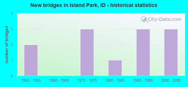
- New bridges - historical statistics
- 21950-1959
- 31970-1979
- 11980-1989
- 31990-1999
- 32000-2009
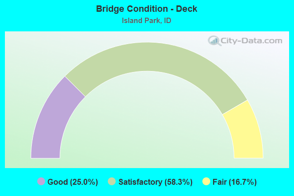
- Bridge Condition - Deck
- 25.0%Good
- 58.3%Satisfactory
- 16.7%Fair
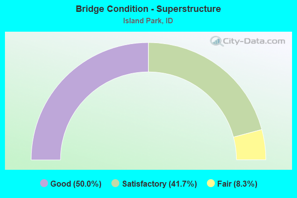
- Bridge Condition - Superstructure
- 50.0%Good
- 41.7%Satisfactory
- 8.3%Fair
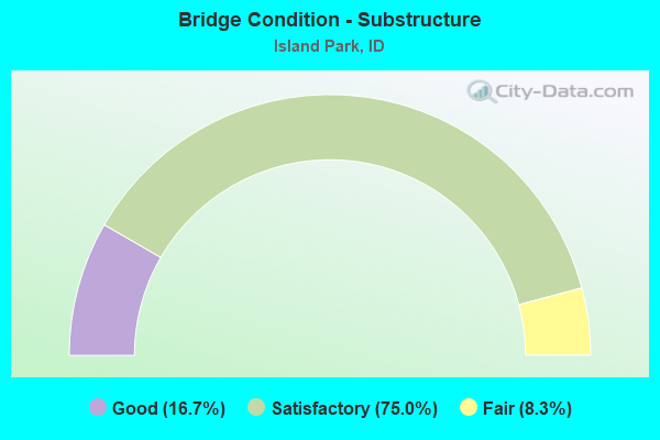
- Bridge Condition - Substructure
- 16.7%Good
- 75.0%Satisfactory
- 8.3%Fair
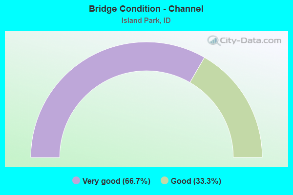
- Bridge Condition - Channel
- 66.7%Very good
- 33.3%Good
Find on map >> Show street view
Structure Number: 12676, Location: 17.8 N. ASHTON (Lat: 44.324444, Lng: -111.448889), Route carried "on" structure: US 20, Year Built: 2001, Status: Open, Structure Length: 7.77m (25.49ft), Average Daily Traffic: 5,600 (year 2019), Truck Traffic: 18%, Average Future Daily Traffic: 8,400 (year 2039), Design Load: HS 25 or greater, Features Intersected: HENRY'S FK. SNAKE RIVER
Minimum Vertical Clearance: 30+ m (98+ ft), Kilometerpoint: 610.172, Lanes on structure: 2, Base Highway Network: Yes (Inventory Route: US0, Subroute: 1), Owner: State Highway Agency, Approaching Roadway Width: 11.6m (38.1ft), Material/Design: Steel continuous, Design/Construction: Stringer/Multi-beam, Number Of Spans In Main Unit: 2, Length of Maximum Span: 38.1m (125.0ft), Curb-To-Curb Width: 11.8m (38.7ft), Out-to-Out Width: 12.6m (41.3ft)
Condition: Deck: Good, Superstructure: Good, Substructure: Good, Channel: Very good, Operating Rating: 57.2 metric tons, Method Used To Determine Operating Rating: Load Factor (LF), Inventory Rating: 33.6 metric tons, Method Used To Determine Inventory Rating: Load Factor (LF), Structural Evaluation: Better than present minimum criteria, Deck Geometry: Somewhat better than minimum adequacy, Waterway Adequacy: Equal to present desirable criteria, Approach Roadway Alignment: Equal to present desirable criteria, Length Of Structure Improvement: 8.93m (29.30ft), Designated Inspection Frequency: Every 48 months, Underwater Inspection Frequency: Every 60 months, Inspection Date: July 2021, Underwater Inspection Date: October 2020, Bridge Improvement Cost: $2,127,000, Roadway Improvement Cost: $213,000, Total Project Cost: $3,191,000 ( Estimate for 2019), Deck Structure Type: Concrete Cast-file-Place, Wearing Surface/Protective System: Wearing Surface: Epoxy Overlay, Deck Protection: Epoxy Coated Reinforcing
Find on map >> Show street view
Structure Number: 1268, Location: 5.7 S. MACKS INN (Lat: 44.421861, Lng: -111.371528), Route carried "on" structure: US 20, Year Built: 1975, Year Reconstructed: 2011, Status: Open, Structure Length: 5.49m (18.01ft), Average Daily Traffic: 5,500 (year 2019), Truck Traffic: 11%, Average Future Daily Traffic: 8,250 (year 2039), Design Load: HS 20, Features Intersected: BUFFALO RIVER;PONDS BR.
Minimum Vertical Clearance: 30+ m (98+ ft), Kilometerpoint: 622.863, Lanes on structure: 2, Base Highway Network: Yes (Inventory Route: US0, Subroute: 1), Owner: State Highway Agency, Approaching Roadway Width: 12.2m (40.0ft), Material/Design: Prestressed concrete, Design/Construction: Stringer/Multi-beam, Number Of Spans In Main Unit: 3, Length of Maximum Span: 18.0m (59.1ft), Curb or Sidewalk Widths: Left: 1.8m (5.9ft), Right: 1.8m (5.9ft), Curb-To-Curb Width: 13.0m (42.7ft), Out-to-Out Width: 18.3m (60.0ft)
Condition: Deck: Good, Superstructure: Good, Substructure: Satisfactory, Channel: Good, Operating Rating: 65.3 metric tons, Method Used To Determine Operating Rating: Load Factor (LF), Inventory Rating: 39.9 metric tons, Method Used To Determine Inventory Rating: Load Factor (LF), Structural Evaluation: Equal to present minimum criteria, Deck Geometry: Somewhat better than minimum adequacy, Waterway Adequacy: Superior to present desirable criteria, Approach Roadway Alignment: Equal to present desirable criteria, Length Of Structure Improvement: 6.46m (21.19ft), Designated Inspection Frequency: Every 48 months, Inspection Date: July 2019, Bridge Improvement Cost: $2,029,000, Roadway Improvement Cost: $203,000, Total Project Cost: $3,043,000 ( Estimate for 2019), Deck Structure Type: Concrete Cast-file-Place, Wearing Surface/Protective System: Wearing Surface: Latex Concrete
Find on map >> Show street view
Structure Number: 12685, Location: AT MACKS INN (Lat: 44.500722, Lng: -111.336667), Route carried "on" structure: US 20, Year Built: 1975, Year Reconstructed: 2011, Status: Open, Structure Length: 5.49m (18.01ft), Average Daily Traffic: 5,500 (year 2019), Truck Traffic: 11%, Average Future Daily Traffic: 8,250 (year 2039), Design Load: HS 20, Features Intersected: HENRY'S FK. SNAKE RIVER
Minimum Vertical Clearance: 30+ m (98+ ft), Kilometerpoint: 632.091, Lanes on structure: 2, Base Highway Network: Yes (Inventory Route: US0, Subroute: 1), Owner: State Highway Agency, Approaching Roadway Width: 12.2m (40.0ft), Material/Design: Prestressed concrete, Design/Construction: Stringer/Multi-beam, Number Of Spans In Main Unit: 3, Length of Maximum Span: 18.0m (59.1ft), Curb or Sidewalk Widths: Left: 1.8m (5.9ft), Right: 1.8m (5.9ft), Curb-To-Curb Width: 13.0m (42.7ft), Out-to-Out Width: 18.3m (60.0ft)
Condition: Deck: Satisfactory, Superstructure: Good, Substructure: Satisfactory, Channel: Very good, Operating Rating: 65.3 metric tons, Method Used To Determine Operating Rating: Load Factor (LF), Inventory Rating: 39.9 metric tons, Method Used To Determine Inventory Rating: Load Factor (LF), Structural Evaluation: Equal to present minimum criteria, Deck Geometry: Somewhat better than minimum adequacy, Waterway Adequacy: Superior to present desirable criteria, Approach Roadway Alignment: Equal to present desirable criteria, Length Of Structure Improvement: 6.46m (21.19ft), Designated Inspection Frequency: Every 48 months, Inspection Date: July 2020, Bridge Improvement Cost: $2,169,000, Roadway Improvement Cost: $217,000, Total Project Cost: $3,254,000 ( Estimate for 2020), Deck Structure Type: Concrete Cast-file-Place, Wearing Surface/Protective System: Wearing Surface: Latex Concrete
Find on map >> Show street view
Structure Number: 1269, Location: 6.0 N. MACKS INN (Lat: 44.585111, Lng: -111.336611), Route carried "on" structure: US 20, Year Built: 1987, Status: Open, Structure Length: 1.83m (6.00ft), Average Daily Traffic: 5,500 (year 2019), Truck Traffic: 11%, Average Future Daily Traffic: 8,250 (year 2039), Design Load: HS 25 or greater, Features Intersected: HENRY'S LAKE OUTLET
Minimum Vertical Clearance: 30+ m (98+ ft), Kilometerpoint: 641.734, Lanes on structure: 2, Base Highway Network: Yes (Inventory Route: US0, Subroute: 1), Owner: State Highway Agency, Approaching Roadway Width: 12.2m (40.0ft), Skew: 3 degrees, Material/Design: Prestressed concrete, Design/Construction: Stringer/Multi-beam, Number Of Spans In Main Unit: 1, Length of Maximum Span: 17.4m (57.1ft), Curb-To-Curb Width: 13.0m (42.7ft), Out-to-Out Width: 14.0m (45.9ft)
Condition: Deck: Satisfactory, Superstructure: Satisfactory, Substructure: Good, Channel: Very good, Operating Rating: 59.9 metric tons, Method Used To Determine Operating Rating: Load Factor (LF), Inventory Rating: 36.3 metric tons, Method Used To Determine Inventory Rating: Load Factor (LF), Structural Evaluation: Equal to present minimum criteria, Deck Geometry: Somewhat better than minimum adequacy, Waterway Adequacy: Equal to present desirable criteria, Approach Roadway Alignment: Equal to present desirable criteria, Length Of Structure Improvement: 2.56m (8.40ft), Designated Inspection Frequency: Every 48 months, Inspection Date: July 2020, Bridge Improvement Cost: $665,000, Roadway Improvement Cost: $65,000, Total Project Cost: $982,000 ( Estimate for 2020), Deck Structure Type: Concrete Cast-file-Place, Wearing Surface/Protective System: Wearing Surface: Bituminous, Deck Protection: Epoxy Coated Reinforcing
Find on map >> Show street view
Structure Number: 17827, Location: 9.4 N. MACKS INN (Lat: 44.634722, Lng: -111.328056), Route carried "on" structure: State highway 87, Year Built: 2005, Status: Open, Structure Length: 1.25m (4.10ft), Average Daily Traffic: 980 (year 2019), Truck Traffic: 35%, Average Future Daily Traffic: 1,470 (year 2039), Design Load: HL 93, Features Intersected: HOWARD CREEK
Minimum Vertical Clearance: 30+ m (98+ ft), Kilometerpoint: 0.097, Lanes on structure: 2, Base Highway Network: Yes, Owner: State Highway Agency, Approaching Roadway Width: 10.4m (34.1ft), Skew: 1 degrees, Material/Design: Prestressed concrete, Design/Construction: Tee Beam, Number Of Spans In Main Unit: 1, Length of Maximum Span: 11.6m (38.1ft), Curb-To-Curb Width: 11.9m (39.0ft), Out-to-Out Width: 12.8m (42.0ft)
Condition: Deck: Satisfactory, Superstructure: Satisfactory, Substructure: Satisfactory, Channel: Very good, Operating Rating: 67.1 metric tons, Method Used To Determine Operating Rating: Load Factor (LF), Inventory Rating: 39.9 metric tons, Method Used To Determine Inventory Rating: Load Factor (LF), Structural Evaluation: Equal to present minimum criteria, Deck Geometry: Better than present minimum criteria, Waterway Adequacy: Superior to present desirable criteria, Approach Roadway Alignment: Equal to present desirable criteria, Designated Inspection Frequency: Every 48 months, Inspection Date: July 2018, Deck Structure Type: Concrete Precast Panels, Wearing Surface/Protective System: Wearing Surface: Bituminous, Membrane: Preformed Fabric, Deck Protection: Epoxy Coated Reinforcing
Find on map >> Show street view
Structure Number: 17829, Location: 10.2 N. MACKS INN (Lat: 44.646444, Lng: -111.341944), Route carried "on" structure: State highway 87, Year Built: 2006, Status: Open, Structure Length: 2.53m (8.30ft), Average Daily Traffic: 980 (year 2019), Truck Traffic: 35%, Average Future Daily Traffic: 1,470 (year 2039), Design Load: HL 93, Features Intersected: TARGHEE CREEK
Minimum Vertical Clearance: 30+ m (98+ ft), Kilometerpoint: 1.820, Lanes on structure: 2, Base Highway Network: Yes, Owner: State Highway Agency, Approaching Roadway Width: 10.7m (35.1ft), Skew: 2 degrees, Material/Design: Prestressed concrete, Design/Construction: Tee Beam, Number Of Spans In Main Unit: 1, Length of Maximum Span: 24.4m (80.1ft), Curb-To-Curb Width: 11.9m (39.0ft), Out-to-Out Width: 12.8m (42.0ft)
Condition: Deck: Satisfactory, Superstructure: Satisfactory, Substructure: Satisfactory, Channel: Very good, Operating Rating: 66.2 metric tons, Method Used To Determine Operating Rating: Load Factor (LF), Inventory Rating: 39.0 metric tons, Method Used To Determine Inventory Rating: Load Factor (LF), Structural Evaluation: Equal to present minimum criteria, Deck Geometry: Better than present minimum criteria, Waterway Adequacy: Superior to present desirable criteria, Approach Roadway Alignment: Equal to present desirable criteria, Designated Inspection Frequency: Every 48 months, Inspection Date: July 2020, Deck Structure Type: Concrete Precast Panels, Wearing Surface/Protective System: Wearing Surface: Bituminous, Membrane: Preformed Fabric, Deck Protection: Epoxy Coated Reinforcing
Find on map >> Show street view
Structure Number: 21101, Location: 2.4 S. 3.2 W. MACKS INN (Lat: 44.463528, Lng: -111.403361), Route carried "on" structure: County highway 6805, Year Built: 1995, Status: Open, Structure Length: 8.23m (27.00ft), Average Daily Traffic: 1,400 (year 2019), Truck Traffic: 7%, Average Future Daily Traffic: 2,100 (year 2039), Design Load: HS 20, Features Intersected: HENRYS FK SNAKE R;MCCREA
Minimum Vertical Clearance: 30+ m (98+ ft), Kilometerpoint: 45.150, Lanes on structure: 2, Owner: County Highway Agency, Approaching Roadway Width: 9.1m (29.9ft), Material/Design: Prestressed concrete, Design/Construction: Stringer/Multi-beam, Number Of Spans In Main Unit: 3, Length of Maximum Span: 27.4m (89.9ft), Curb or Sidewalk Widths: Left: 0.0m, Right: 2.6m (8.5ft), Curb-To-Curb Width: 9.2m (30.2ft), Out-to-Out Width: 12.9m (42.3ft)
Condition: Deck: Satisfactory, Superstructure: Good, Substructure: Satisfactory, Channel: Good, Operating Rating: 85.3 metric tons, Method Used To Determine Operating Rating: Load Factor (LF), Inventory Rating: 39.0 metric tons, Method Used To Determine Inventory Rating: Load Factor (LF), Structural Evaluation: Equal to present minimum criteria, Deck Geometry: Somewhat better than minimum adequacy, Waterway Adequacy: Superior to present desirable criteria, Approach Roadway Alignment: Equal to present desirable criteria, Designated Inspection Frequency: Every 48 months, Underwater Inspection Frequency: Every 60 months, Inspection Date: October 2021, Underwater Inspection Date: October 2020, Deck Structure Type: Concrete Cast-file-Place, Wearing Surface/Protective System: Wearing Surface: Monolithic Concrete, Deck Protection: Epoxy Coated Reinforcing
Find on map >> Show street view
Structure Number: 3213, Location: 4.8 E. MACKS INN (Lat: 44.499667, Lng: -111.255611), Route carried "on" structure: County highway 6807, Year Built: 1958, Status: Posted for load, Structure Length: 3.35m (10.99ft), Average Daily Traffic: 160 (year 2019), Truck Traffic: 6%, Average Future Daily Traffic: 240 (year 2039), Design Load: H 20, Features Intersected: BIG SPRINGS;ISLAND PK.BR
Minimum Vertical Clearance: 30+ m (98+ ft), Kilometerpoint: 7.759, Lanes on structure: 2, Owner: County Highway Agency, Approaching Roadway Width: 8.5m (27.9ft), Material/Design: Wood or Timber, Design/Construction: Stringer/Multi-beam, Number Of Spans In Main Unit: 4, Length of Maximum Span: 8.2m (26.9ft), Curb or Sidewalk Widths: Left: 1.2m (3.9ft), Right: 1.7m (5.6ft), Curb-To-Curb Width: 8.8m (28.9ft), Out-to-Out Width: 12.6m (41.3ft)
Condition: Deck: Satisfactory, Superstructure: Satisfactory, Substructure: Satisfactory, Channel: Very good, Operating Rating: 27.2 metric tons, Method Used To Determine Operating Rating: Allowable Stress (AS), Inventory Rating: 18.1 metric tons, Method Used To Determine Inventory Rating: Allowable Stress (AS), Structural Evaluation: Somewhat better than minimum adequacy, Deck Geometry: Equal to present minimum criteria, Waterway Adequacy: Equal to present desirable criteria, Approach Roadway Alignment: Better than present minimum criteria, Bridge Posting: Required (Relationship of Operating Rating to Maximum Legal Load: 20.0 - 29.9% below), Length Of Structure Improvement: 4.30m (14.11ft), Designated Inspection Frequency: Every 24 months, Underwater Inspection Frequency: Every 60 months, Inspection Date: October 2020, Underwater Inspection Date: October 2020, Bridge Improvement Cost: $1,024,000, Roadway Improvement Cost: $102,000, Total Project Cost: $1,536,000 ( Estimate for 2020), Deck Structure Type: Wood or Timber, Wearing Surface/Protective System: Wearing Surface: Bituminous
Find on map >> Show street view
Structure Number: 32181, Location: 0.9 W. 2.4 E. MACKS INN (Lat: 44.512028, Lng: -111.290861), Route carried "on" structure: Federal lands road 6807, Year Built: 1992, Status: Open, Structure Length: 2.16m (7.09ft), Average Daily Traffic: 890 (year 2019), Truck Traffic: 1%, Average Future Daily Traffic: 1,335 (year 2039), Design Load: HS 20, Features Intersected: HENRYS LAKE OUTLET
Minimum Vertical Clearance: 30+ m (98+ ft), Kilometerpoint: 164.026, Lanes on structure: 2, Owner: County Highway Agency, Approaching Roadway Width: 6.7m (22.0ft), Material/Design: Prestressed concrete, Design/Construction: Tee Beam, Number Of Spans In Main Unit: 1, Length of Maximum Span: 21.3m (69.9ft), Curb-To-Curb Width: 8.5m (27.9ft), Out-to-Out Width: 9.1m (29.9ft)
Condition: Deck: Satisfactory, Superstructure: Satisfactory, Substructure: Satisfactory, Channel: Good, Operating Rating: 34.5 metric tons, Method Used To Determine Operating Rating: Field evaluation and documented engineering judgment, Inventory Rating: 20.9 metric tons, Method Used To Determine Inventory Rating: Field evaluation and documented engineering judgment, Structural Evaluation: Somewhat better than minimum adequacy, Deck Geometry: Somewhat better than minimum adequacy, Waterway Adequacy: Superior to present desirable criteria, Approach Roadway Alignment: Equal to present desirable criteria, Length Of Structure Improvement: 2.93m (9.61ft), Designated Inspection Frequency: Every 24 months, Inspection Date: October 2020, Bridge Improvement Cost: $539,000, Roadway Improvement Cost: $54,000, Total Project Cost: $809,000 ( Estimate for 2020), Deck Structure Type: Concrete Cast-file-Place, Wearing Surface/Protective System: Wearing Surface: Gravel
Find on map >> Show street view
Structure Number: 41502000001031, Location: NO DATA ENTERED (Lat: 44.512044, Lng: -111.290642), Route carried "on" structure: Federal lands road 80059, Year Built: 1991, Status: Open, Structure Length: 2.13m (6.99ft), Average Daily Traffic: 50 (year 0000), Average Future Daily Traffic: 75 (year 2042), Design Load: HS 20, Features Intersected: HENRYS LAKE OUTLET, Facility Carried by Structure: ROAD
Minimum Vertical Clearance: 30+ m (98+ ft), Kilometerpoint: 3.200, Lanes on structure: 2, Owner: U.S. Forest Service, Approaching Roadway Width: 8.5m (27.9ft), Material/Design: Prestressed concrete, Design/Construction: Tee Beam, Number Of Spans In Main Unit: 1, Length of Maximum Span: 21.0m (68.9ft), Curb or Sidewalk Widths: Left: 0.3m (1.0ft), Right: 0.3m (1.0ft), Curb-To-Curb Width: 8.5m (27.9ft), Out-to-Out Width: 9.1m (29.9ft)
Condition: Deck: Fair, Superstructure: Fair, Substructure: Satisfactory, Channel: Very good, Operating Rating: 33.0 metric tons, Method Used To Determine Operating Rating: Load and Resistance Factor Rating (LRFR) rating reported by rating factor(RF) method using HL-93 loadings, Inventory Rating: 24.9 metric tons, Method Used To Determine Inventory Rating: Load and Resistance Factor Rating (LRFR) rating reported by rating factor(RF) method using HL-93 loadings, Structural Evaluation: Somewhat better than minimum adequacy, Deck Geometry: Better than present minimum criteria, Waterway Adequacy: Superior to present desirable criteria, Approach Roadway Alignment: Equal to present desirable criteria, Designated Inspection Frequency: Every 24 months, Inspection Date: October 2021, Deck Structure Type: Other, Wearing Surface/Protective System: Wearing Surface: Bituminous
Find on map >> Show street view
Structure Number: 41502000001032, Location: NO DATA ENTERED (Lat: 44.499450, Lng: -111.255297), Route carried "on" structure: Federal lands road 80059, Year Built: 1957, Status: Open, Structure Length: 3.54m (11.61ft), Average Daily Traffic: 50 (year 0000), Average Future Daily Traffic: 75 (year 2042), Features Intersected: BIG SPRINGS OUTLET, Facility Carried by Structure: ROAD
Minimum Vertical Clearance: 30+ m (98+ ft), Kilometerpoint: 7.040, Lanes on structure: 2, Owner: U.S. Forest Service, Approaching Roadway Width: 12.2m (40.0ft), Material/Design: Wood or Timber, Design/Construction: Stringer/Multi-beam, Number Of Spans In Main Unit: 1, Length of Maximum Span: 8.2m (26.9ft), Curb or Sidewalk Widths: Left: 0.9m (3.0ft), Right: 0.9m (3.0ft), Curb-To-Curb Width: 12.2m (40.0ft), Out-to-Out Width: 14.0m (45.9ft)
Condition: Deck: Fair, Superstructure: Good, Substructure: Fair, Channel: Very good, Operating Rating: 28.5 metric tons, Method Used To Determine Operating Rating: Load and Resistance Factor Rating (LRFR) rating reported by rating factor(RF) method using HL-93 loadings, Inventory Rating: 22.0 metric tons, Method Used To Determine Inventory Rating: Load and Resistance Factor Rating (LRFR) rating reported by rating factor(RF) method using HL-93 loadings, Structural Evaluation: Somewhat better than minimum adequacy, Deck Geometry: Superior to present desirable criteria, Waterway Adequacy: Superior to present desirable criteria, Approach Roadway Alignment: Equal to present minimum criteria, Designated Inspection Frequency: Every 24 months, Inspection Date: October 2021, Deck Structure Type: Wood or Timber, Wearing Surface/Protective System: Wearing Surface: Bituminous
Find on map >> Show street view
Structure Number: 41502000001034, Location: NO DATA ENTERED (Lat: 44.484397, Lng: -111.280989), Route carried "on" structure: Federal lands road 80082, Year Built: 1978, Status: Open, Structure Length: 0.98m (3.22ft), Average Daily Traffic: 50 (year 0000), Average Future Daily Traffic: 75 (year 2042), Design Load: HS 20, Features Intersected: LUCKY DOG CREEK, Facility Carried by Structure: ROAD
Minimum Vertical Clearance: 30+ m (98+ ft), Kilometerpoint: 64.656, Lanes on structure: 2, Owner: U.S. Forest Service, Approaching Roadway Width: 7.9m (25.9ft), Material/Design: Prestressed concrete, Design/Construction: Tee Beam, Number Of Spans In Main Unit: 1, Length of Maximum Span: 9.4m (30.8ft), Curb or Sidewalk Widths: Left: 0.3m (1.0ft), Right: 0.3m (1.0ft), Curb-To-Curb Width: 7.9m (25.9ft), Out-to-Out Width: 8.6m (28.2ft)
Condition: Deck: Good, Superstructure: Good, Substructure: Satisfactory, Channel: Good, Waterway Adequacy: Superior to present desirable criteria, Approach Roadway Alignment: Equal to present desirable criteria, Designated Inspection Frequency: Every 24 months, Inspection Date: October 2021, Deck Structure Type: Other, Wearing Surface/Protective System: Wearing Surface: Monolithic Concrete