Bridge Statistics for Ivanhoe, Texas (TX)
Condition, Traffic, Stress, Structural Evaluation, Project Costs
- National Bridge Inventory (NBI) Statistics
- 10Number of bridges
- 348ft / 106mTotal length
- $262,000Total costs
- 13,727Total average daily traffic
- 1,220Total average daily truck traffic
- 18,059Total future (year 1900) average daily traffic
- National Bridge Inventory (NBI) Registered Bridges for Ivanhoe
- No street view available for this location
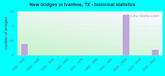
- New bridges - historical statistics
- 21930-1939
- 72000-2009
- 12020-2022
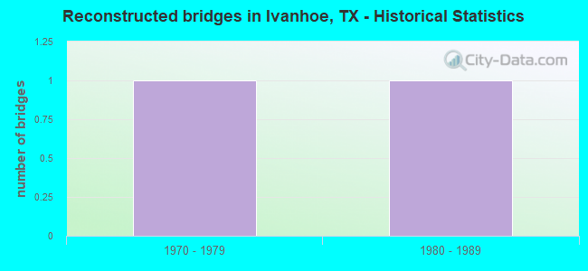
- Reconstructed bridges - Historical Statistics
- 11970-1979
- 11980-1989
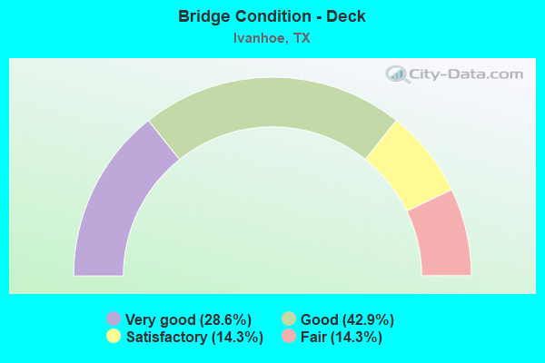
- Bridge Condition - Deck
- 28.6%Very good
- 42.9%Good
- 14.3%Satisfactory
- 14.3%Fair
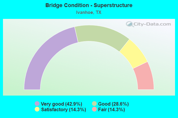
- Bridge Condition - Superstructure
- 42.9%Very good
- 28.6%Good
- 14.3%Satisfactory
- 14.3%Fair
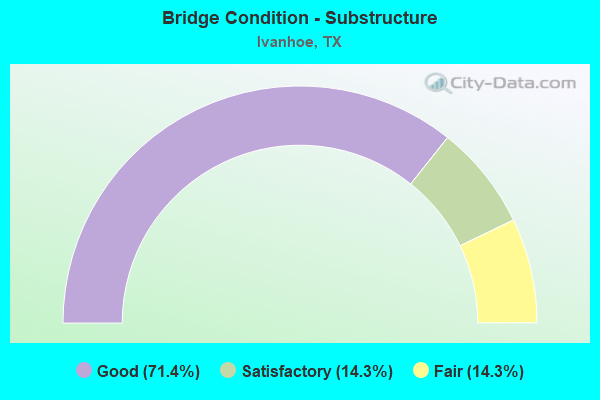
- Bridge Condition - Substructure
- 71.4%Good
- 14.3%Satisfactory
- 14.3%Fair
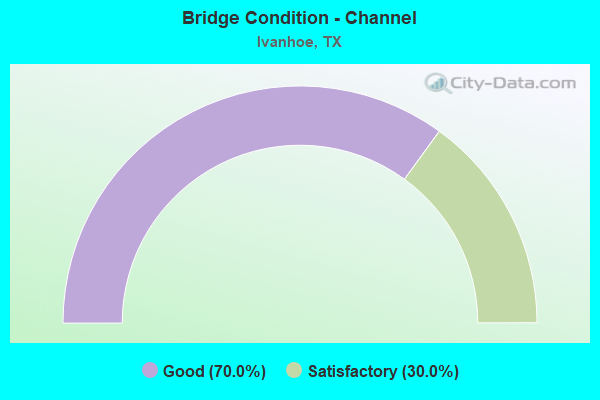
- Bridge Condition - Channel
- 70.0%Good
- 30.0%Satisfactory
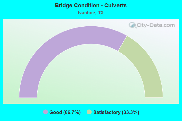
- Bridge Condition - Culverts
- 66.7%Good
- 33.3%Satisfactory
Find on map >> Show street view
Structure Number: 10750027902192, Location: 10.5 MI N of US 82 (Lat: 33.753117, Lng: -96.196236), Route carried "on" structure: State highway 78, Year Built: 2021, Status: Open, Structure Length: 70.04m (229.79ft), Average Daily Traffic: 2,331 (year 2018), Average Future Daily Traffic: 1 (year 1900), Design Load: HL 93, Features Intersected: Red River
Minimum Vertical Clearance: 30+ m (98+ ft), Kilometerpoint: 147.094, Lanes on structure: 2, Base Highway Network: Yes, Owner: State Agenciy, Approaching Roadway Width: 13.4m (44.0ft), Material/Design: Prestressed concrete, Design/Construction: Stringer/Multi-beam, Number Of Spans In Main Unit: 17, Length of Maximum Span: 41.1m (134.8ft), Curb-To-Curb Width: 13.4m (44.0ft), Out-to-Out Width: 14.1m (46.3ft)
Condition: Deck: Good, Superstructure: Very good, Substructure: Good, Channel: Good, Operating Rating: 54.4 metric tons, Method Used To Determine Operating Rating: Assigned ratings based on Load and Resistance Factor Design (LRFD) reported in metric tons, Inventory Rating: 32.7 metric tons, Method Used To Determine Inventory Rating: Load and Resistance Factor (LRFR), Structural Evaluation: Better than present minimum criteria, Deck Geometry: Better than present minimum criteria, Waterway Adequacy: Superior to present desirable criteria, Approach Roadway Alignment: Equal to present desirable criteria, Designated Inspection Frequency: Every 24 months, Inspection Date: March 2021, Deck Structure Type: Concrete Precast Panels
Find on map >> Show street view
Structure Number: 202290020005016, Location: 1.15 MI S OF JASPER C/L (Lat: 31.008739, Lng: -94.398517), Route carried "on" structure: US 69, Year Built: 1932, Year Reconstructed: 1985, Status: Open, Structure Length: 1.62m (5.31ft), Average Daily Traffic: 2,571 (year 2020), Truck Traffic: 15%, Average Future Daily Traffic: 3,850 (year 2033), Design Load: H 15, Features Intersected: GREENWOOD CREEK
Minimum Vertical Clearance: 30+ m (98+ ft), Kilometerpoint: 17.601, Lanes on structure: 2, Owner: State Highway Agency, Approaching Roadway Width: 13.4m (44.0ft), Material/Design: Concrete, Design/Construction: Culvert, Number Of Spans In Main Unit: 6, Length of Maximum Span: 2.4m (7.9ft), Curb-To-Curb Width: 14.6m (47.9ft), Out-to-Out Width: 15.3m (50.2ft)
Condition: Channel: Good, Culverts: Satisfactory, Operating Rating: 39.9 metric tons, Method Used To Determine Operating Rating: Load Factor (LF), Inventory Rating: 23.6 metric tons, Method Used To Determine Inventory Rating: Load Factor (LF), Structural Evaluation: Equal to present minimum criteria, Deck Geometry: Superior to present desirable criteria, Waterway Adequacy: Equal to present minimum criteria, Approach Roadway Alignment: Equal to present desirable criteria, Designated Inspection Frequency: Every 24 months, Inspection Date: July 2020, Deck Structure Type: Concrete Cast-file-Place, Wearing Surface/Protective System: Wearing Surface: Bituminous
Find on map >> Show street view
Structure Number: 202290020008022, Location: 0.70 MI S OF FM 1013 (Lat: 30.659978, Lng: -94.390917), Route carried "on" structure: US 69, Year Built: 1932, Year Reconstructed: 1979, Status: Open, Structure Length: 18.29m (60.01ft), Average Daily Traffic: 5,765 (year 2020), Truck Traffic: 11%, Average Future Daily Traffic: 8,990 (year 2033), Design Load: H 15, Features Intersected: BIG CYPRESS CREEK
Minimum Vertical Clearance: 30+ m (98+ ft), Kilometerpoint: 1.297, Lanes on structure: 2, Owner: State Highway Agency, Approaching Roadway Width: 13.4m (44.0ft), Material/Design: Steel continuous, Design/Construction: Stringer/Multi-beam, Number Of Spans In Main Unit: 30, Length of Maximum Span: 6.1m (20.0ft), Curb-To-Curb Width: 13.3m (43.6ft), Out-to-Out Width: 14.1m (46.3ft)
Condition: Deck: Fair, Superstructure: Fair, Substructure: Satisfactory, Channel: Good, Operating Rating: 48.1 metric tons, Method Used To Determine Operating Rating: Load Factor (LF), Inventory Rating: 29.0 metric tons, Method Used To Determine Inventory Rating: Load Factor (LF), Structural Evaluation: Somewhat better than minimum adequacy, Deck Geometry: Somewhat better than minimum adequacy, Waterway Adequacy: Equal to present minimum criteria, Approach Roadway Alignment: Equal to present desirable criteria, Designated Inspection Frequency: Every 24 months, Inspection Date: July 2020, Deck Structure Type: Concrete Cast-file-Place, Wearing Surface/Protective System: Wearing Surface: Bituminous
Find on map >> Show street view
Structure Number: 202290123701012, Location: 2.30 MI E OF US 69 (Lat: 30.675750, Lng: -94.350047), Route carried "on" structure: State highway 1013, Year Built: 2008, Status: Open, Structure Length: 3.66m (12.01ft), Average Daily Traffic: 1,147 (year 2020), Truck Traffic: 8%, Average Future Daily Traffic: 2,120 (year 2033), Design Load: HL 93, Features Intersected: TURKEY CREEK
Minimum Vertical Clearance: 30+ m (98+ ft), Kilometerpoint: 3.684, Lanes on structure: 2, Owner: State Highway Agency, Approaching Roadway Width: 7.9m (25.9ft), Skew: 3 degrees, Material/Design: Prestressed concrete, Design/Construction: Slab, Number Of Spans In Main Unit: 3, Length of Maximum Span: 12.2m (40.0ft), Curb-To-Curb Width: 11.4m (37.4ft), Out-to-Out Width: 12.3m (40.4ft)
Condition: Deck: Very good, Superstructure: Very good, Substructure: Good, Channel: Good, Operating Rating: 54.4 metric tons, Method Used To Determine Operating Rating: Assigned ratings based on Load and Resistance Factor Design (LRFD) reported in metric tons, Inventory Rating: 32.7 metric tons, Method Used To Determine Inventory Rating: Assigned ratings based on Load and Resistance Factor Design (LRFD) reported in metric tons, Structural Evaluation: Better than present minimum criteria, Deck Geometry: Equal to present minimum criteria, Waterway Adequacy: Equal to present minimum criteria, Approach Roadway Alignment: Meets minimum limits, Length Of Structure Improvement: 3.87m (12.70ft), Designated Inspection Frequency: Every 24 months, Inspection Date: June 2020, Bridge Improvement Cost: $196,000, Roadway Improvement Cost: $49,000, Total Project Cost: $249,000, Deck Structure Type: Concrete Cast-file-Place
Find on map >> Show street view
Structure Number: 202290123701013, Location: 0.80 MI E OF US 69 (Lat: 30.669803, Lng: -94.373889), Route carried "on" structure: State highway 1013, Year Built: 2007, Status: Open, Structure Length: 1.37m (4.49ft), Average Daily Traffic: 1,147 (year 2020), Truck Traffic: 8%, Average Future Daily Traffic: 2,120 (year 2033), Design Load: HL 93, Features Intersected: BIG BRANCH
Minimum Vertical Clearance: 30+ m (98+ ft), Kilometerpoint: 1.297, Lanes on structure: 2, Owner: State Highway Agency, Approaching Roadway Width: 7.9m (25.9ft), Material/Design: Prestressed concrete, Design/Construction: Slab, Number Of Spans In Main Unit: 1, Length of Maximum Span: 13.7m (44.9ft), Curb-To-Curb Width: 11.4m (37.4ft), Out-to-Out Width: 12.3m (40.4ft)
Condition: Deck: Very good, Superstructure: Very good, Substructure: Good, Channel: Good, Operating Rating: 54.4 metric tons, Method Used To Determine Operating Rating: Assigned ratings based on Load and Resistance Factor Design (LRFD) reported in metric tons, Inventory Rating: 32.7 metric tons, Method Used To Determine Inventory Rating: Assigned ratings based on Load and Resistance Factor Design (LRFD) reported in metric tons, Structural Evaluation: Better than present minimum criteria, Deck Geometry: Equal to present minimum criteria, Waterway Adequacy: Superior to present desirable criteria, Approach Roadway Alignment: Somewhat better than minimum adequacy, Designated Inspection Frequency: Every 24 months, Inspection Date: June 2020, Deck Structure Type: Concrete Cast-file-Place
Find on map >> Show street view
Structure Number: 202290AA0315001, Location: 1.0 MI NE OF CR 4260 (Lat: 30.720058, Lng: -94.380528), Route carried "on" structure: County highway 4280, Year Built: 2006, Status: Open, Structure Length: 1.65m (5.41ft), Average Daily Traffic: 131 (year 2016), Truck Traffic: 3%, Average Future Daily Traffic: 131 (year 2037), Design Load: HS 20, Features Intersected: TURKEY CREEK
Minimum Vertical Clearance: 30+ m (98+ ft), Kilometerpoint: 1.609, Lanes on structure: 2, Owner: County Highway Agency, Approaching Roadway Width: 4.9m (16.1ft), Material/Design: Concrete, Design/Construction: Culvert, Number Of Spans In Main Unit: 5, Length of Maximum Span: 3.0m (9.8ft)
Condition: Channel: Satisfactory, Culverts: Good, Operating Rating: 54.4 metric tons, Method Used To Determine Operating Rating: Assigned rating based on Load Factor Design (LFD) reported in metric tons, Inventory Rating: 32.7 metric tons, Method Used To Determine Inventory Rating: Assigned rating based on Load Factor Design (LFD) reported in metric tons, Structural Evaluation: Better than present minimum criteria, Waterway Adequacy: Meets minimum limits, Approach Roadway Alignment: Better than present minimum criteria, Length Of Structure Improvement: 2.62m (8.60ft), Designated Inspection Frequency: Every 24 months, Inspection Date: August 2021
Find on map >> Show street view
Structure Number: 202290AA0315002, Location: 2.0 MI E OF CR 4260 (Lat: 30.721592, Lng: -94.364022), Route carried "on" structure: County highway 4280, Year Built: 2005, Status: Open, Structure Length: 1.14m (3.74ft), Average Daily Traffic: 131 (year 2016), Truck Traffic: 3%, Average Future Daily Traffic: 131 (year 2037), Design Load: HS 20, Features Intersected: HUNTERS CREEK
Minimum Vertical Clearance: 30+ m (98+ ft), Kilometerpoint: 3.219, Lanes on structure: 2, Owner: County Highway Agency, Approaching Roadway Width: 4.9m (16.1ft), Skew: 3 degrees, Material/Design: Concrete, Design/Construction: Culvert, Number Of Spans In Main Unit: 3, Length of Maximum Span: 3.7m (12.1ft), Curb-To-Curb Width: 12.8m (42.0ft), Out-to-Out Width: 13.4m (44.0ft)
Condition: Channel: Satisfactory, Culverts: Good, Operating Rating: 54.4 metric tons, Method Used To Determine Operating Rating: Assigned rating based on Load Factor Design (LFD) reported in metric tons, Inventory Rating: 32.7 metric tons, Method Used To Determine Inventory Rating: Assigned rating based on Load Factor Design (LFD) reported in metric tons, Structural Evaluation: Better than present minimum criteria, Deck Geometry: Superior to present desirable criteria, Waterway Adequacy: Equal to present minimum criteria, Approach Roadway Alignment: Equal to present desirable criteria, Designated Inspection Frequency: Every 24 months, Inspection Date: August 2021
Find on map >> Show street view
Structure Number: 202290AA0318001, Location: 0.6 MI SW OF US 69 (Lat: 30.668853, Lng: -94.395756), Route carried "on" structure: County highway , Year Built: 2000, Status: Open, Structure Length: 1.25m (4.10ft), Average Daily Traffic: 22 (year 2016), Truck Traffic: 3%, Average Future Daily Traffic: 30 (year 2037), Features Intersected: MAGNUS BRANCH, Facility Carried by Structure: CR 1205
Minimum Vertical Clearance: 30+ m (98+ ft), Kilometerpoint: 0.966, Lanes on structure: 1, Owner: County Highway Agency, Approaching Roadway Width: 3.0m (9.8ft), Material/Design: Steel continuous, Design/Construction: Stringer/Multi-beam, Number Of Spans In Main Unit: 2, Length of Maximum Span: 6.1m (20.0ft), Curb-To-Curb Width: 4.0m (13.1ft), Out-to-Out Width: 4.3m (14.1ft)
Condition: Deck: Satisfactory, Superstructure: Satisfactory, Substructure: Fair, Channel: Satisfactory, Operating Rating: 48.1 metric tons, Method Used To Determine Operating Rating: Allowable Stress (AS), Inventory Rating: 26.3 metric tons, Method Used To Determine Inventory Rating: Allowable Stress (AS), Structural Evaluation: Somewhat better than minimum adequacy, Deck Geometry: Somewhat better than minimum adequacy, Waterway Adequacy: Meets minimum limits, Approach Roadway Alignment: Somewhat better than minimum adequacy, Designated Inspection Frequency: Every 24 months, Inspection Date: August 2021, Roadway Improvement Cost: $5,000, Total Project Cost: $13,000, Deck Structure Type: Wood or Timber, Wearing Surface/Protective System: Wearing Surface: Wood or Timber
Find on map >> Show street view
Structure Number: 202290E00101001, Location: 0.8 Mi S of Ivanhoe Dr (Lat: 30.673750, Lng: -94.401481), Route carried "on" structure: City street , Year Built: 2003, Status: Open, Structure Length: 4.88m (16.01ft), Average Daily Traffic: 351 (year 2016), Truck Traffic: 3%, Average Future Daily Traffic: 490 (year 2040), Features Intersected: LAKE CHARMAINE, Facility Carried by Structure: CAMELOT DR S
Minimum Vertical Clearance: 30+ m (98+ ft), Kilometerpoint: 1.287, Lanes on structure: 1, Owner: City or Municipal Highway Agency, Approaching Roadway Width: 7.3m (24.0ft), Material/Design: Concrete, Design/Construction: Slab, Number Of Spans In Main Unit: 10, Length of Maximum Span: 4.9m (16.1ft), Curb-To-Curb Width: 3.4m (11.2ft), Out-to-Out Width: 3.7m (12.1ft)
Condition: Deck: Good, Superstructure: Good, Substructure: Good, Channel: Good, Operating Rating: 32.7 metric tons, Method Used To Determine Operating Rating: Field evaluation and documented engineering judgment, Inventory Rating: 24.5 metric tons, Method Used To Determine Inventory Rating: Field evaluation and documented engineering judgment, Structural Evaluation: Equal to present minimum criteria, Deck Geometry: High priority of replacement, Waterway Adequacy: Equal to present minimum criteria, Approach Roadway Alignment: Equal to present desirable criteria, Designated Inspection Frequency: Every 24 months, Inspection Date: August 2021, Deck Structure Type: Concrete Cast-file-Place, Wearing Surface/Protective System: Wearing Surface: Monolithic Concrete
Find on map >> Show street view
Structure Number: 202290E00201001, Location: 1 Mi SW of Chanticleer Dr (Lat: 30.675664, Lng: -94.419519), Route carried "on" structure: City street , Year Built: 2003, Status: Open, Structure Length: 1.95m (6.40ft), Average Daily Traffic: 131 (year 2020), Truck Traffic: 3%, Average Future Daily Traffic: 196 (year 2040), Features Intersected: LAKE GALAHAD, Facility Carried by Structure: LAKEWOOD DR
Minimum Vertical Clearance: 30+ m (98+ ft), Kilometerpoint: 1.609, Lanes on structure: 2, Owner: City or Municipal Highway Agency, Approaching Roadway Width: 7.3m (24.0ft), Material/Design: Concrete, Design/Construction: Slab, Number Of Spans In Main Unit: 4, Length of Maximum Span: 4.9m (16.1ft), Curb-To-Curb Width: 7.3m (24.0ft), Out-to-Out Width: 7.3m (24.0ft)
Condition: Deck: Good, Superstructure: Good, Substructure: Good, Channel: Good, Operating Rating: 32.7 metric tons, Method Used To Determine Operating Rating: Field evaluation and documented engineering judgment, Inventory Rating: 24.5 metric tons, Method Used To Determine Inventory Rating: Field evaluation and documented engineering judgment, Structural Evaluation: Equal to present minimum criteria, Deck Geometry: Somewhat better than minimum adequacy, Waterway Adequacy: Meets minimum limits, Approach Roadway Alignment: Equal to present desirable criteria, Bridge Posting: Required (Relationship of Operating Rating to Maximum Legal Load: > 39.9% below), Designated Inspection Frequency: Every 24 months, Inspection Date: August 2021, Deck Structure Type: Concrete Cast-file-Place, Wearing Surface/Protective System: Wearing Surface: Monolithic Concrete