Bridge Statistics for Jacksonville, Oregon (OR)
Condition, Traffic, Stress, Structural Evaluation, Project Costs
- National Bridge Inventory (NBI) Statistics
- 12Number of bridges
- 59ft / 17.9mTotal length
- $195,000Total costs
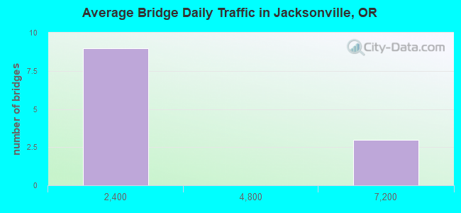
- 26,613Total average daily traffic
- 2,810Total average daily truck traffic
- 34,191Total future (year 2025) average daily traffic
- National Bridge Inventory (NBI) Registered Bridges for Jacksonville
- No street view available for this location
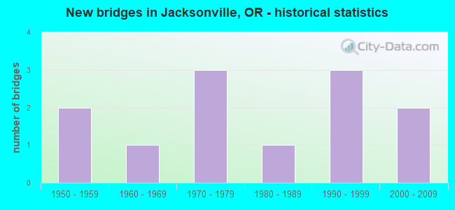
- New bridges - historical statistics
- 21950-1959
- 11960-1969
- 31970-1979
- 11980-1989
- 31990-1999
- 22000-2009
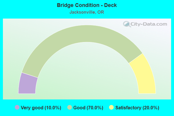
- Bridge Condition - Deck
- 10.0%Very good
- 70.0%Good
- 20.0%Satisfactory
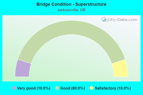
- Bridge Condition - Superstructure
- 10.0%Very good
- 80.0%Good
- 10.0%Satisfactory
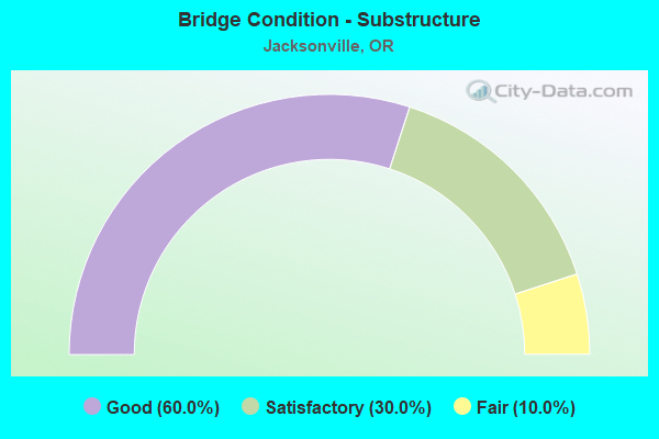
- Bridge Condition - Substructure
- 60.0%Good
- 30.0%Satisfactory
- 10.0%Fair
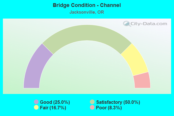
- Bridge Condition - Channel
- 25.0%Good
- 50.0%Satisfactory
- 16.7%Fair
- 8.3%Poor
Find on map >> Show street view
Structure Number: 3774A272 03304, Location: 00.6 S JACKSONVILLE WCL (Lat: 42.315661, Lng: -122.972489), Route carried "on" structure: State highway 238, Year Built: 1964, Status: Open, Structure Length: 0.82m (2.69ft), Average Daily Traffic: 6,999 (year 2020), Truck Traffic: 12%, Average Future Daily Traffic: 9,000 (year 2040), Design Load: HS 20, Features Intersected: JACKSON CREEK
Minimum Vertical Clearance: 30+ m (98+ ft), Kilometerpoint: 53.173, Lanes on structure: 2, Base Highway Network: Yes, Owner: State Highway Agency, Approaching Roadway Width: 9.1m (29.9ft), Skew: 4 degrees, Material/Design: Concrete continuous, Design/Construction: Culvert, Number Of Spans In Main Unit: 2, Length of Maximum Span: 4.3m (14.1ft)
Condition: Channel: Satisfactory, Culverts: Satisfactory, Operating Rating: 36.9 metric tons, Method Used To Determine Operating Rating: Load and Resistance Factor Rating (LRFR) rating reported by rating factor(RF) method using HL-93 loadings, Inventory Rating: 28.5 metric tons, Method Used To Determine Inventory Rating: Load and Resistance Factor Rating (LRFR) rating reported by rating factor(RF) method using HL-93 loadings, Structural Evaluation: Equal to present minimum criteria, Waterway Adequacy: Equal to present minimum criteria, Approach Roadway Alignment: Equal to present desirable criteria, Designated Inspection Frequency: Every 24 months, Inspection Date: October 2021
Find on map >> Show street view
Structure Number: 7813 789 00334, Location: 3.34 MILEPOST (Lat: 42.331800, Lng: -122.936200), Route carried "on" structure: State highway 238, Year Built: 1954, Status: Open, Structure Length: 0.80m (2.62ft), Average Daily Traffic: 6,148 (year 2020), Truck Traffic: 12%, Average Future Daily Traffic: 8,200 (year 2040), Design Load: HS 20, Features Intersected: JACKSON CR/HANLEY ROAD
Minimum Vertical Clearance: 30+ m (98+ ft), Kilometerpoint: 57.035, Lanes on structure: 2, Base Highway Network: Yes, Owner: State Highway Agency, Approaching Roadway Width: 9.1m (29.9ft), Skew: 4 degrees, Material/Design: Concrete continuous, Design/Construction: Culvert, Number Of Spans In Main Unit: 2, Length of Maximum Span: 3.8m (12.5ft)
Condition: Channel: Poor, Culverts: Satisfactory, Operating Rating: 24.3 metric tons, Method Used To Determine Operating Rating: Load and Resistance Factor Rating (LRFR) rating reported by rating factor(RF) method using HL-93 loadings, Inventory Rating: 18.8 metric tons, Method Used To Determine Inventory Rating: Load and Resistance Factor Rating (LRFR) rating reported by rating factor(RF) method using HL-93 loadings, Structural Evaluation: Meets minimum limits, Waterway Adequacy: Better than present minimum criteria, Approach Roadway Alignment: Equal to present desirable criteria, Designated Inspection Frequency: Every 24 months, Inspection Date: October 2021, Deck Structure Type: Concrete Cast-file-Place, Wearing Surface/Protective System: Wearing Surface: Bituminous
Find on map >> Show street view
Structure Number: 8372 584, Location: 0.09 N OF OR 238 (Lat: 42.315917, Lng: -122.967806), Route carried "on" structure: City street , Year Built: 1957, Status: Open, Structure Length: 0.61m (2.00ft), Average Daily Traffic: 1,545 (year 2020), Truck Traffic: 5%, Average Future Daily Traffic: 1,798 (year 2025), Design Load: HS 20, Features Intersected: JACKSON CREEK, Facility Carried by Structure: OREGON STREET
Minimum Vertical Clearance: 30+ m (98+ ft), Kilometerpoint: 0.000, Lanes on structure: 2, Owner: City or Municipal Highway Agency, Approaching Roadway Width: 9.1m (29.9ft), Skew: 3 degrees, Material/Design: Concrete, Design/Construction: Slab, Number Of Spans In Main Unit: 1, Length of Maximum Span: 6.1m (20.0ft), Curb or Sidewalk Widths: Left: 1.5m (4.9ft), Right: 1.5m (4.9ft), Curb-To-Curb Width: 7.9m (25.9ft), Out-to-Out Width: 11.4m (37.4ft)
Condition: Deck: Good, Superstructure: Good, Substructure: Satisfactory, Channel: Satisfactory, Operating Rating: 39.9 metric tons, Method Used To Determine Operating Rating: Load Factor (LF), Inventory Rating: 24.5 metric tons, Method Used To Determine Inventory Rating: Load Factor (LF), Structural Evaluation: Equal to present minimum criteria, Deck Geometry: Meets minimum limits, Waterway Adequacy: Equal to present desirable criteria, Approach Roadway Alignment: Equal to present desirable criteria, Designated Inspection Frequency: Every 24 months, Inspection Date: June 2021, Deck Structure Type: Concrete Cast-file-Place, Wearing Surface/Protective System: Wearing Surface: Bituminous
Find on map >> Show street view
Structure Number: 11783, Location: 700 M S DAYTON (Lat: 45.129550, Lng: -123.035089), Route carried "on" structure: County highway C0029, Year Built: 1976, Status: Open, Structure Length: 4.24m (13.91ft), Average Daily Traffic: 242 (year 2020), Truck Traffic: 10%, Average Future Daily Traffic: 272 (year 2025), Design Load: HS 20, Features Intersected: MOSQUITO CREEK, Facility Carried by Structure: GRAND ISLAND ROAD
Minimum Vertical Clearance: 30+ m (98+ ft), Kilometerpoint: 1.770, Lanes on structure: 2, Owner: County Highway Agency, Approaching Roadway Width: 9.1m (29.9ft), Skew: 4 degrees, Material/Design: Prestressed concrete, Design/Construction: Slab, Number Of Spans In Main Unit: 3, Length of Maximum Span: 14.6m (47.9ft), Curb-To-Curb Width: 8.9m (29.2ft), Out-to-Out Width: 9.7m (31.8ft)
Condition: Deck: Satisfactory, Superstructure: Good, Substructure: Good, Channel: Fair, Operating Rating: 88.9 metric tons, Method Used To Determine Operating Rating: Allowable Stress (AS), Inventory Rating: 54.4 metric tons, Method Used To Determine Inventory Rating: Allowable Stress (AS), Structural Evaluation: Better than present minimum criteria, Deck Geometry: Equal to present minimum criteria, Waterway Adequacy: Equal to present minimum criteria, Approach Roadway Alignment: Equal to present desirable criteria, Designated Inspection Frequency: Every 24 months, Inspection Date: September 2020, Deck Structure Type: Other, Wearing Surface/Protective System: Wearing Surface: Monolithic Concrete
Find on map >> Show street view
Structure Number: 14448, Location: 0027 MI E OF HWY 34 (Lat: 44.409550, Lng: -123.567611), Route carried "on" structure: County highway , Year Built: 1970, Status: Open, Structure Length: 3.60m (11.81ft), Average Daily Traffic: 27 (year 2020), Average Future Daily Traffic: 43 (year 2040), Design Load: HS 20, Features Intersected: NO. FK. ALSEA RIVER, Facility Carried by Structure: SEELEY CR RD
Minimum Vertical Clearance: 30+ m (98+ ft), Kilometerpoint: 0.435, Lanes on structure: 1, Owner: County Highway Agency, Approaching Roadway Width: 5.2m (17.1ft), Material/Design: Prestressed concrete, Design/Construction: Slab, Number Of Spans In Main Unit: 3, Length of Maximum Span: 12.8m (42.0ft), Curb-To-Curb Width: 4.3m (14.1ft), Out-to-Out Width: 4.9m (16.1ft)
Condition: Deck: Good, Superstructure: Good, Substructure: Satisfactory, Channel: Satisfactory, Operating Rating: 59.0 metric tons, Method Used To Determine Operating Rating: Load Factor (LF), Inventory Rating: 35.4 metric tons, Method Used To Determine Inventory Rating: Load Factor (LF), Structural Evaluation: Equal to present minimum criteria, Deck Geometry: Equal to present minimum criteria, Waterway Adequacy: Equal to present desirable criteria, Approach Roadway Alignment: Equal to present desirable criteria, Designated Inspection Frequency: Every 24 months, Underwater Inspection Frequency: Every 60 months, Inspection Date: July 2020, Underwater Inspection Date: October 2020, Deck Structure Type: Other, Wearing Surface/Protective System: Wearing Surface: Bituminous
Find on map >> Show street view
Structure Number: 14517, Location: 0070 E OF PETTIBONE RD (Lat: 44.631289, Lng: -123.217511), Route carried "on" structure: County highway , Year Built: 1990, Status: Open, Structure Length: 1.16m (3.81ft), Average Daily Traffic: 2,250 (year 2020), Truck Traffic: 10%, Average Future Daily Traffic: 3,060 (year 2040), Design Load: HS 20, Features Intersected: FRAZIER CREEK, Facility Carried by Structure: NE GRANGER AVE
Minimum Vertical Clearance: 30+ m (98+ ft), Kilometerpoint: 1.802, Lanes on structure: 2, Owner: County Highway Agency, Approaching Roadway Width: 7.6m (24.9ft), Skew: 1 degrees, Material/Design: Wood or Timber, Design/Construction: Stringer/Multi-beam, Number Of Spans In Main Unit: 1, Length of Maximum Span: 11.0m (36.1ft), Curb-To-Curb Width: 10.9m (35.8ft), Out-to-Out Width: 11.2m (36.7ft)
Condition: Deck: Good, Superstructure: Good, Substructure: Good, Channel: Satisfactory, Operating Rating: 28.2 metric tons, Method Used To Determine Operating Rating: Load and Resistance Factor Rating (LRFR) rating reported by rating factor(RF) method using HL-93 loadings, Inventory Rating: 21.7 metric tons, Method Used To Determine Inventory Rating: Load and Resistance Factor Rating (LRFR) rating reported by rating factor(RF) method using HL-93 loadings, Structural Evaluation: Somewhat better than minimum adequacy, Deck Geometry: Somewhat better than minimum adequacy, Waterway Adequacy: Equal to present minimum criteria, Approach Roadway Alignment: Equal to present desirable criteria, Designated Inspection Frequency: Every 24 months, Inspection Date: July 2020, Deck Structure Type: Wood or Timber, Wearing Surface/Protective System: Wearing Surface: Bituminous
Find on map >> Show street view
Structure Number: 19672, Location: 0.2 MI N OF OR 238 (Lat: 42.316269, Lng: -122.966831), Route carried "on" structure: City street , Year Built: 1970, Status: Open, Structure Length: 0.76m (2.49ft), Average Daily Traffic: 1,327 (year 2020), Truck Traffic: 5%, Average Future Daily Traffic: 1,472 (year 2025), Design Load: HS 20, Features Intersected: JACKSON CREEK, Facility Carried by Structure: E STREET
Minimum Vertical Clearance: 30+ m (98+ ft), Kilometerpoint: 0.000, Lanes on structure: 2, Owner: City or Municipal Highway Agency, Approaching Roadway Width: 7.6m (24.9ft), Skew: 1 degrees, Material/Design: Prestressed concrete, Design/Construction: Slab, Number Of Spans In Main Unit: 1, Length of Maximum Span: 7.6m (24.9ft), Curb or Sidewalk Widths: Left: 0.0m, Right: 1.7m (5.6ft), Curb-To-Curb Width: 8.3m (27.2ft), Out-to-Out Width: 10.1m (33.1ft)
Condition: Deck: Good, Superstructure: Good, Substructure: Satisfactory, Channel: Satisfactory, Operating Rating: 55.3 metric tons, Method Used To Determine Operating Rating: Load Factor (LF), Inventory Rating: 33.6 metric tons, Method Used To Determine Inventory Rating: Load Factor (LF), Structural Evaluation: Equal to present minimum criteria, Deck Geometry: Meets minimum limits, Waterway Adequacy: Equal to present minimum criteria, Approach Roadway Alignment: Equal to present desirable criteria, Designated Inspection Frequency: Every 24 months, Inspection Date: June 2021, Deck Structure Type: Other, Wearing Surface/Protective System: Wearing Surface: Bituminous
Find on map >> Show street view
Structure Number: 19673, Location: 0.22 MI N OF OR 238 (Lat: 42.316681, Lng: -122.965619), Route carried "on" structure: City street , Year Built: 1997, Status: Open, Structure Length: 1.17m (3.84ft), Average Daily Traffic: 1,327 (year 2020), Truck Traffic: 5%, Average Future Daily Traffic: 1,472 (year 2025), Design Load: HS 20, Features Intersected: JACKSON CREEK, Facility Carried by Structure: F STREET
Minimum Vertical Clearance: 30+ m (98+ ft), Kilometerpoint: 0.000, Lanes on structure: 2, Owner: City or Municipal Highway Agency, Approaching Roadway Width: 9.1m (29.9ft), Skew: 1 degrees, Material/Design: Prestressed concrete, Design/Construction: Slab, Number Of Spans In Main Unit: 1, Length of Maximum Span: 11.7m (38.4ft), Curb-To-Curb Width: 7.8m (25.6ft), Out-to-Out Width: 9.8m (32.2ft)
Condition: Deck: Good, Superstructure: Good, Substructure: Fair, Channel: Fair, Operating Rating: 67.1 metric tons, Method Used To Determine Operating Rating: Load Factor (LF), Inventory Rating: 40.8 metric tons, Method Used To Determine Inventory Rating: Load Factor (LF), Structural Evaluation: Somewhat better than minimum adequacy, Deck Geometry: Meets minimum limits, Waterway Adequacy: Equal to present minimum criteria, Approach Roadway Alignment: Equal to present desirable criteria, Designated Inspection Frequency: Every 24 months, Inspection Date: June 2021, Deck Structure Type: Other, Wearing Surface/Protective System: Wearing Surface: Bituminous
Find on map >> Show street view
Structure Number: 19727 272 03494, Location: 3.87 MILEPOST (Lat: 42.326000, Lng: -122.942850), Route carried "on" structure: State highway 238, Year Built: 2006, Status: Open, Structure Length: 1.47m (4.82ft), Average Daily Traffic: 6,148 (year 2020), Truck Traffic: 12%, Average Future Daily Traffic: 8,200 (year 2040), Design Load: HL 93, Features Intersected: JACKSON CR/HANLEY RD.
Minimum Vertical Clearance: 30+ m (98+ ft), Kilometerpoint: 56.230, Lanes on structure: 2, Base Highway Network: Yes, Owner: State Highway Agency, Approaching Roadway Width: 18.0m (59.1ft), Skew: 4 degrees, Material/Design: Prestressed concrete, Design/Construction: Slab, Number Of Spans In Main Unit: 1, Length of Maximum Span: 14.7m (48.2ft), Curb-To-Curb Width: 18.0m (59.1ft), Out-to-Out Width: 19.5m (64.0ft)
Condition: Deck: Very good, Superstructure: Very good, Substructure: Good, Channel: Good, Operating Rating: 52.2 metric tons, Method Used To Determine Operating Rating: Load and Resistance Factor Rating (LRFR) rating reported by rating factor(RF) method using HL-93 loadings, Inventory Rating: 40.2 metric tons, Method Used To Determine Inventory Rating: Load and Resistance Factor Rating (LRFR) rating reported by rating factor(RF) method using HL-93 loadings, Structural Evaluation: Better than present minimum criteria, Deck Geometry: Superior to present desirable criteria, Waterway Adequacy: Equal to present desirable criteria, Approach Roadway Alignment: Equal to present desirable criteria, Designated Inspection Frequency: Every 24 months, Inspection Date: October 2021, Deck Structure Type: Concrete Precast Panels, Wearing Surface/Protective System: Wearing Surface: Bituminous, Membrane: Preformed Fabric
Find on map >> Show street view
Structure Number: 19925, Location: 0.5 N OF OR 238 (Lat: 42.318889, Lng: -122.961833), Route carried "on" structure: City street , Year Built: 1997, Status: Open, Structure Length: 1.22m (4.00ft), Average Daily Traffic: 239 (year 2020), Truck Traffic: 5%, Average Future Daily Traffic: 254 (year 2025), Design Load: HS 20, Features Intersected: JACKSON CREEK, Facility Carried by Structure: G STREET
Minimum Vertical Clearance: 30+ m (98+ ft), Kilometerpoint: 0.000, Lanes on structure: 2, Owner: City or Municipal Highway Agency, Approaching Roadway Width: 7.3m (24.0ft), Material/Design: Prestressed concrete, Design/Construction: Slab, Number Of Spans In Main Unit: 1, Length of Maximum Span: 11.9m (39.0ft), Curb or Sidewalk Widths: Left: 1.6m (5.2ft), Right: 0.3m (1.0ft), Curb-To-Curb Width: 7.3m (24.0ft), Out-to-Out Width: 9.8m (32.2ft)
Condition: Deck: Satisfactory, Superstructure: Satisfactory, Substructure: Good, Channel: Satisfactory, Operating Rating: 65.1 metric tons, Method Used To Determine Operating Rating: Load and Resistance Factor Rating (LRFR) rating reported by rating factor(RF) method using HL-93 loadings, Inventory Rating: 50.2 metric tons, Method Used To Determine Inventory Rating: Load and Resistance Factor Rating (LRFR) rating reported by rating factor(RF) method using HL-93 loadings, Structural Evaluation: Equal to present minimum criteria, Deck Geometry: Somewhat better than minimum adequacy, Waterway Adequacy: Equal to present desirable criteria, Approach Roadway Alignment: Equal to present minimum criteria, Designated Inspection Frequency: Every 24 months, Inspection Date: June 2021, Deck Structure Type: Other, Wearing Surface/Protective System: Wearing Surface: Bituminous
Find on map >> Show street view
Structure Number: 19926, Location: 0.05 N OF OR 238 (Lat: 42.315561, Lng: -122.969931), Route carried "on" structure: City street , Year Built: 2000, Status: Open, Structure Length: 1.16m (3.81ft), Average Daily Traffic: 79 (year 2020), Truck Traffic: 1%, Average Future Daily Traffic: 92 (year 2025), Design Load: HS 20, Features Intersected: JACKSON CREEK, Facility Carried by Structure: C STREET
Minimum Vertical Clearance: 30+ m (98+ ft), Kilometerpoint: 0.000, Lanes on structure: 1, Owner: City or Municipal Highway Agency, Approaching Roadway Width: 4.9m (16.1ft), Material/Design: Prestressed concrete, Design/Construction: Slab, Number Of Spans In Main Unit: 1, Length of Maximum Span: 11.3m (37.1ft), Curb-To-Curb Width: 4.9m (16.1ft), Out-to-Out Width: 4.9m (16.1ft)
Condition: Deck: Good, Superstructure: Good, Substructure: Good, Channel: Good, Operating Rating: 82.6 metric tons, Method Used To Determine Operating Rating: Load Factor (LF), Inventory Rating: 49.0 metric tons, Method Used To Determine Inventory Rating: Load Factor (LF), Structural Evaluation: Better than present minimum criteria, Deck Geometry: High priority of corrective action, Waterway Adequacy: Equal to present desirable criteria, Approach Roadway Alignment: Equal to present desirable criteria, Length Of Structure Improvement: 1.20m (3.94ft), Designated Inspection Frequency: Every 24 months, Inspection Date: June 2021, Bridge Improvement Cost: $122,000, Roadway Improvement Cost: $12,000, Total Project Cost: $195,000, Deck Structure Type: Other
Find on map >> Show street view
Structure Number: 29C274756 00075, Location: 0.75 MILEPOST (Lat: 42.316439, Lng: -122.997550), Route carried "on" structure: County highway C0756, Year Built: 1986, Status: Open, Structure Length: 0.91m (2.99ft), Average Daily Traffic: 282 (year 2020), Truck Traffic: 10%, Average Future Daily Traffic: 328 (year 2025), Design Load: HS 20, Features Intersected: JACKSON CR/JACKSON RESV, Facility Carried by Structure: COUNTY RD 756
Minimum Vertical Clearance: 30+ m (98+ ft), Kilometerpoint: 1.207, Lanes on structure: 2, Owner: County Highway Agency, Approaching Roadway Width: 5.5m (18.0ft), Skew: 4 degrees, Material/Design: Prestressed concrete, Design/Construction: Slab, Number Of Spans In Main Unit: 1, Length of Maximum Span: 8.5m (27.9ft), Curb-To-Curb Width: 7.2m (23.6ft), Out-to-Out Width: 7.3m (24.0ft)
Condition: Deck: Good, Superstructure: Good, Substructure: Good, Channel: Good, Operating Rating: 88.9 metric tons, Method Used To Determine Operating Rating: Load Factor (LF), Inventory Rating: 62.6 metric tons, Method Used To Determine Inventory Rating: Load Factor (LF), Structural Evaluation: Better than present minimum criteria, Deck Geometry: Meets minimum limits, Waterway Adequacy: Equal to present minimum criteria, Approach Roadway Alignment: Equal to present desirable criteria, Designated Inspection Frequency: Every 24 months, Inspection Date: June 2021, Deck Structure Type: Other, Wearing Surface/Protective System: Wearing Surface: Monolithic Concrete