Bridge Statistics for Joffre, Pennsylvania (PA)
Condition, Traffic, Stress, Structural Evaluation, Project Costs
- National Bridge Inventory (NBI) Statistics
- 16Number of bridges
- 85ft / 25.5mTotal length
- $1,936,000Total costs
- 81,574Total average daily traffic
- 8,026Total average daily truck traffic
- National Bridge Inventory (NBI) Registered Bridges for Joffre
- No street view available for this location
- New bridges - historical statistics
- 1Before 1900
- 11900-1909
- 11920-1929
- 21940-1949
- 31960-1969
- 31970-1979
- 11990-1999
- 12000-2009
- 32010-2019
- Reconstructed bridges - Historical Statistics
- 11960-1969
- 01970-1979
- 01980-1989
- 01990-1999
- 02000-2009
- 32010-2019
- Bridge Condition - Deck
- 25.0%Very good
- 37.5%Good
- 37.5%Fair
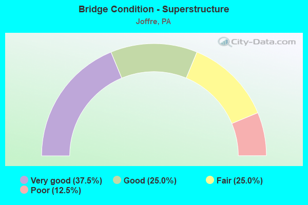
- Bridge Condition - Superstructure
- 37.5%Very good
- 25.0%Good
- 25.0%Fair
- 12.5%Poor
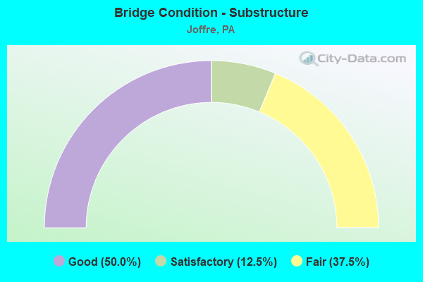
- Bridge Condition - Substructure
- 50.0%Good
- 12.5%Satisfactory
- 37.5%Fair
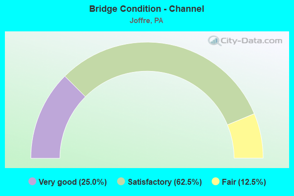
- Bridge Condition - Channel
- 25.0%Very good
- 62.5%Satisfactory
- 12.5%Fair
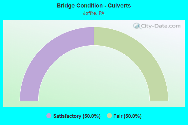
- Bridge Condition - Culverts
- 50.0%Satisfactory
- 50.0%Fair
Find on map >> Show street view
Structure Number: 35105, Location: SMITH & ROBINSON TWP. (Lat: 40.424836, Lng: -80.358394), Route carried "on" structure: State highway , Year Built: 1928, Status: Open, Structure Length: 1.22m (4.00ft), Average Daily Traffic: 3,712 (year 2020), Truck Traffic: 2%, Average Future Daily Traffic: 4,642 (year 2032), Design Load: HS 20, Features Intersected: LITTLE RACCOON RUN, Facility Carried by Structure: SR 4004
Minimum Vertical Clearance: 30+ m (98+ ft), Kilometerpoint: 15.390, Lanes on structure: 2, Owner: State Highway Agency, Approaching Roadway Width: 70.1m (230.0ft), Skew: 4 degrees, Material/Design: Concrete, Design/Construction: Culvert, Number Of Spans In Main Unit: 1, Length of Maximum Span: 12.2m (40.0ft)
Condition: Channel: Satisfactory, Culverts: Satisfactory, Inventory Rating: 99.8 metric tons, Method Used To Determine Inventory Rating: Load Factor (LF), Structural Evaluation: Equal to present minimum criteria, Waterway Adequacy: Superior to present desirable criteria, Approach Roadway Alignment: Equal to present desirable criteria, Length Of Structure Improvement: 1.20m (3.94ft), Designated Inspection Frequency: Every 24 months, Inspection Date: October 2021, Bridge Improvement Cost: $59,000, Roadway Improvement Cost: $174,000, Total Project Cost: $798,000
Find on map >> Show street view
Structure Number: 3512, Location: SMITH TOWNSHIP (Lat: 40.423183, Lng: -80.369756), Route carried "on" structure: State highway , Year Built: 1970, Status: Open, Structure Length: 0.94m (3.08ft), Average Daily Traffic: 2,857 (year 2020), Truck Traffic: 2%, Average Future Daily Traffic: 3,589 (year 2032), Design Load: HS 20, Features Intersected: BRANCH OF RACCOON CREEK, Facility Carried by Structure: SR 4007
Minimum Vertical Clearance: 30+ m (98+ ft), Kilometerpoint: 4.096, Lanes on structure: 2, Owner: State Highway Agency, Approaching Roadway Width: 9.1m (29.9ft), Skew: 4 degrees, Material/Design: Concrete, Design/Construction: Culvert, Number Of Spans In Main Unit: 1, Length of Maximum Span: 7.6m (24.9ft)
Condition: Channel: Satisfactory, Culverts: Fair, Inventory Rating: 99.8 metric tons, Method Used To Determine Inventory Rating: Load Factor (LF), Structural Evaluation: Somewhat better than minimum adequacy, Waterway Adequacy: Superior to present desirable criteria, Approach Roadway Alignment: Equal to present desirable criteria, Length Of Structure Improvement: 1.60m (5.25ft), Designated Inspection Frequency: Every 24 months, Inspection Date: June 2020
Find on map >> Show street view
Structure Number: 3513, Location: SMITH TOWNSHIP (Lat: 40.383631, Lng: -80.367725), Route carried "on" structure: State highway , Year Built: 1947, Year Reconstructed: 1972, Status: Open, Structure Length: 1.68m (5.51ft), Average Daily Traffic: 1,856 (year 2022), Truck Traffic: 8%, Average Future Daily Traffic: 2,785 (year 2032), Design Load: H 20, Features Intersected: BURGETTS FORK, Facility Carried by Structure: SR 4012
Minimum Vertical Clearance: 30+ m (98+ ft), Kilometerpoint: 1.254, Lanes on structure: 2, Owner: State Highway Agency, Approaching Roadway Width: 10.1m (33.1ft), Material/Design: Steel, Design/Construction: Stringer/Multi-beam, Number Of Spans In Main Unit: 1, Length of Maximum Span: 16.2m (53.1ft), Curb or Sidewalk Widths: Left: 0.2m (0.7ft), Right: 0.2m (0.7ft), Curb-To-Curb Width: 11.6m (38.1ft), Out-to-Out Width: 12.2m (40.0ft)
Condition: Deck: Fair, Superstructure: Fair, Substructure: Fair, Channel: Satisfactory, Operating Rating: 46.3 metric tons, Method Used To Determine Operating Rating: Load Factor (LF), Inventory Rating: 27.2 metric tons, Method Used To Determine Inventory Rating: Load Factor (LF), Structural Evaluation: Somewhat better than minimum adequacy, Deck Geometry: Equal to present minimum criteria, Waterway Adequacy: Superior to present desirable criteria, Approach Roadway Alignment: Equal to present desirable criteria, Length Of Structure Improvement: 1.60m (5.25ft), Designated Inspection Frequency: Every 24 months, Inspection Date: June 2020, Bridge Improvement Cost: $5,000, Roadway Improvement Cost: $14,000, Total Project Cost: $64,000, Deck Structure Type: Closed Grating, Wearing Surface/Protective System: Wearing Surface: Bituminous
Find on map >> Show street view
Structure Number: 35151, Location: SMITH TOWNSHIP (Lat: 40.357919, Lng: -80.357275), Route carried "on" structure: State highway , Year Built: 1948, Status: Posted for load, Structure Length: 1.34m (4.40ft), Average Daily Traffic: 1,404 (year 2022), Truck Traffic: 9%, Average Future Daily Traffic: 771 (year 2032), Design Load: H 15, Features Intersected: RACCOON CREEK, Facility Carried by Structure: SR 4017
Minimum Vertical Clearance: 30+ m (98+ ft), Kilometerpoint: 2.432, Lanes on structure: 2, Owner: State Highway Agency, Approaching Roadway Width: 4.9m (16.1ft), Material/Design: Steel, Design/Construction: Stringer/Multi-beam, Number Of Spans In Main Unit: 1, Length of Maximum Span: 13.1m (43.0ft), Curb or Sidewalk Widths: Left: 0.2m (0.7ft), Right: 0.2m (0.7ft), Curb-To-Curb Width: 4.3m (14.1ft), Out-to-Out Width: 4.8m (15.7ft)
Condition: Deck: Fair, Superstructure: Fair, Substructure: Fair, Channel: Fair, Operating Rating: 30.8 metric tons, Method Used To Determine Operating Rating: Load Factor (LF), Inventory Rating: 18.1 metric tons, Method Used To Determine Inventory Rating: Load Factor (LF), Structural Evaluation: Somewhat better than minimum adequacy, Deck Geometry: High priority of replacement, Waterway Adequacy: Superior to present desirable criteria, Approach Roadway Alignment: Equal to present desirable criteria, Bridge Posting: Required (Relationship of Operating Rating to Maximum Legal Load: 20.0 - 29.9% below), Length Of Structure Improvement: 2.00m (6.56ft), Designated Inspection Frequency: Every 24 months, Other Special Inspection Frequency: Every 12 months, Inspection Date: June 2020, Other Special Inspection Date: June 2021, Bridge Improvement Cost: $5,000, Roadway Improvement Cost: $14,000, Total Project Cost: $64,000, Deck Structure Type: Wood or Timber
Find on map >> Show street view
Structure Number: 35177, Location: ROBINSON TOWNSHIP (Lat: 40.420169, Lng: -80.349422), Route carried "on" structure: State highway , Year Built: 1968, Year Reconstructed: 2019, Status: Open, Structure Length: 4.05m (13.29ft), Average Daily Traffic: 3,624 (year 2022), Truck Traffic: 9%, Average Future Daily Traffic: 1,795 (year 2032), Design Load: HL 93, Features Intersected: SR 0022, Facility Carried by Structure: SR 4026
Minimum Vertical Clearance: 30+ m (98+ ft), Kilometerpoint: 0.000, Lanes on structure: 2, Lanes under structure: 8, Owner: State Highway Agency, Approaching Roadway Width: 12.2m (40.0ft), Skew: 3 degrees, Material/Design: Prestressed concrete continuous, Design/Construction: Box Beam or Girders - Single/Spread, Number Of Spans In Main Unit: 2, Length of Maximum Span: 20.1m (65.9ft), Curb-To-Curb Width: 12.6m (41.3ft), Out-to-Out Width: 13.3m (43.6ft)
Condition: Deck: Very good, Superstructure: Very good, Substructure: Satisfactory, Operating Rating: 42.1 metric tons, Method Used To Determine Operating Rating: Assigned ratings based on Load and Resistance Factor Design (LRFD) reported by rating factor (RF) using HL93 loadings, Inventory Rating: 32.4 metric tons, Method Used To Determine Inventory Rating: Assigned ratings based on Load and Resistance Factor Design (LRFD) reported by rating factor (RF) using HL93 loadings, Structural Evaluation: Equal to present minimum criteria, Deck Geometry: Equal to present minimum criteria, Underclear: Somewhat better than minimum adequacy, Approach Roadway Alignment: Equal to present desirable criteria, Length Of Structure Improvement: 4.90m (16.08ft), Designated Inspection Frequency: Every 24 months, Inspection Date: October 2021, Bridge Improvement Cost: $44,000, Roadway Improvement Cost: $128,000, Total Project Cost: $588,000, Deck Structure Type: Concrete Cast-file-Place, Wearing Surface/Protective System: Wearing Surface: Monolithic Concrete, Deck Protection: Epoxy Coated Reinforcing
Find on map >> Show street view
Structure Number: 35333, Location: 300' WEST OF SR 4075 (Lat: 40.371192, Lng: -80.364667), Route carried "on" structure: City street T821, Year Built: 1903, Year Reconstructed: 2017, Status: Posted for load, Structure Length: 1.86m (6.10ft), Average Daily Traffic: 80 (year 1993), Average Future Daily Traffic: 80 (year 2000), Design Load: H 15, Features Intersected: RACCOON CREEK, Facility Carried by Structure: KEYS BRIDGE TR 719
Minimum Vertical Clearance: 30+ m (98+ ft), Kilometerpoint: 0.000, Lanes on structure: 1, Base Highway Network: Yes, Owner: County Highway Agency, Approaching Roadway Width: 3.0m (9.8ft), Material/Design: Steel, Design/Construction: Truss - Thru, Number Of Spans In Main Unit: 1, Length of Maximum Span: 17.7m (58.1ft), Curb-To-Curb Width: 3.7m (12.1ft), Out-to-Out Width: 4.2m (13.8ft)
Condition: Deck: Fair, Superstructure: Poor, Substructure: Fair, Channel: Satisfactory, Operating Rating: 6.4 metric tons, Method Used To Determine Operating Rating: Load Factor (LF), Inventory Rating: 3.6 metric tons, Method Used To Determine Inventory Rating: Load Factor (LF), Structural Evaluation: High priority of replacement, Deck Geometry: Meets minimum limits, Waterway Adequacy: Better than present minimum criteria, Approach Roadway Alignment: Meets minimum limits, Bridge Posting: Required (Relationship of Operating Rating to Maximum Legal Load: > 39.9% below), Length Of Structure Improvement: 2.50m (8.20ft), Designated Inspection Frequency: Every 24 months, Critical Feature Inspection Frequency: Every 12 months, Other Special Inspection Frequency: Every 12 months, Inspection Date: August 2021, Critical Feature Inspection Date: August 2021, Other Special Inspection Date: August 2021, Bridge Improvement Cost: $29,000, Roadway Improvement Cost: $86,000, Total Project Cost: $394,000, Deck Structure Type: Wood or Timber
Find on map >> Show street view
Structure Number: 35334, Location: @ T843/T700 INTERSECTION (Lat: 40.403750, Lng: -80.363361), Route carried "on" structure: City street T320, Year Built: 1889, Year Reconstructed: 2016, Status: Open, Structure Length: 1.95m (6.40ft), Average Daily Traffic: 15 (year 2016), Average Future Daily Traffic: 15 (year 2016), Design Load: HL 93, Features Intersected: RACCOON CREEK
Minimum Vertical Clearance: 30+ m (98+ ft), Kilometerpoint: 0.000, Lanes on structure: 1, Base Highway Network: Yes, Owner: County Highway Agency, Approaching Roadway Width: 2.7m (8.9ft), Material/Design: Steel, Design/Construction: Truss - Thru, Number Of Spans In Main Unit: 1, Length of Maximum Span: 18.0m (59.1ft), Curb-To-Curb Width: 3.7m (12.1ft), Out-to-Out Width: 4.3m (14.1ft)
Condition: Deck: Very good, Superstructure: Very good, Substructure: Good, Channel: Satisfactory, Operating Rating: 80.7 metric tons, Method Used To Determine Operating Rating: Load Factor (LF), Inventory Rating: 48.1 metric tons, Method Used To Determine Inventory Rating: Load Factor (LF), Structural Evaluation: Better than present minimum criteria, Deck Geometry: Meets minimum limits, Waterway Adequacy: Better than present minimum criteria, Approach Roadway Alignment: Somewhat better than minimum adequacy, Length Of Structure Improvement: 2.60m (8.53ft), Designated Inspection Frequency: Every 24 months, Critical Feature Inspection Frequency: Every 24 months, Inspection Date: July 2021, Critical Feature Inspection Date: July 2021, Bridge Improvement Cost: $2,000, Roadway Improvement Cost: $6,000, Total Project Cost: $28,000, Deck Structure Type: Corrugated Steel, Wearing Surface/Protective System: Wearing Surface: Bituminous
Find on map >> Show street view
Structure Number: 39927, Location: HANOVER & SMITH TOWNSHIP (Lat: 40.421667, Lng: -80.368333), Route carried "on" structure: State highway , Year Built: 1997, Status: Open, Structure Length: 3.23m (10.60ft), Average Daily Traffic: 3,712 (year 2020), Truck Traffic: 2%, Average Future Daily Traffic: 4,642 (year 2032), Design Load: HS 25 or greater, Features Intersected: RACCOON CREEK, Facility Carried by Structure: SR 4004
Minimum Vertical Clearance: 30+ m (98+ ft), Kilometerpoint: 14.040, Lanes on structure: 2, Owner: State Highway Agency, Approaching Roadway Width: 9.1m (29.9ft), Material/Design: Prestressed concrete, Design/Construction: Stringer/Multi-beam, Number Of Spans In Main Unit: 1, Length of Maximum Span: 32.3m (106.0ft), Curb or Sidewalk Widths: Left: 0.2m (0.7ft), Right: 0.2m (0.7ft), Curb-To-Curb Width: 9.1m (29.9ft), Out-to-Out Width: 10.2m (33.5ft)
Condition: Deck: Good, Superstructure: Very good, Substructure: Good, Channel: Very good, Operating Rating: 94.3 metric tons, Method Used To Determine Operating Rating: Load Factor (LF), Inventory Rating: 47.2 metric tons, Method Used To Determine Inventory Rating: Load Factor (LF), Structural Evaluation: Better than present minimum criteria, Deck Geometry: Meets minimum limits, Waterway Adequacy: Superior to present desirable criteria, Approach Roadway Alignment: Equal to present desirable criteria, Length Of Structure Improvement: 4.10m (13.45ft), Designated Inspection Frequency: Every 48 months, Inspection Date: June 2018, Deck Structure Type: Concrete Cast-file-Place, Wearing Surface/Protective System: Wearing Surface: Epoxy Overlay, Deck Protection: Epoxy Coated Reinforcing
Find on map >> Show street view
Structure Number: 44377, Location: 400' North of TR 861 (Lat: 40.437097, Lng: -80.364375), Route carried "on" structure: City street , Year Built: 2007, Status: Open, Structure Length: 2.50m (8.20ft), Average Daily Traffic: 65 (year 2019), Average Future Daily Traffic: 65 (year 2039), Design Load: HL 93, Features Intersected: RACCOON CREEK, Facility Carried by Structure: Raccoon Creek Road
Minimum Vertical Clearance: 30+ m (98+ ft), Kilometerpoint: 0.000, Lanes on structure: 2, Owner: County Highway Agency, Approaching Roadway Width: 7.9m (25.9ft), Skew: 1 degrees, Material/Design: Prestressed concrete, Design/Construction: Box Beam or Girders - Multiple, Number Of Spans In Main Unit: 1, Length of Maximum Span: 24.4m (80.1ft), Curb or Sidewalk Widths: Left: 0.2m (0.7ft), Right: 0.2m (0.7ft), Curb-To-Curb Width: 7.9m (25.9ft), Out-to-Out Width: 8.9m (29.2ft)
Condition: Deck: Good, Superstructure: Good, Substructure: Good, Channel: Very good, Operating Rating: 65.8 metric tons, Method Used To Determine Operating Rating: Load and Resistance Factor Rating (LRFR) rating reported by rating factor(RF) method using HL-93 loadings, Inventory Rating: 38.6 metric tons, Method Used To Determine Inventory Rating: Load and Resistance Factor Rating (LRFR) rating reported by rating factor(RF) method using HL-93 loadings, Structural Evaluation: Better than present minimum criteria, Deck Geometry: Equal to present minimum criteria, Waterway Adequacy: Superior to present desirable criteria, Approach Roadway Alignment: Equal to present minimum criteria, Designated Inspection Frequency: Every 24 months, Inspection Date: August 2021, Deck Structure Type: Concrete Cast-file-Place, Wearing Surface/Protective System: Wearing Surface: Monolithic Concrete, Deck Protection: Epoxy Coated Reinforcing
Find on map >> Show street view
Structure Number: 57191, Location: SMITH TOWNSHIP (Lat: 40.422583, Lng: -80.370028), Route carried "on" structure: State highway , Year Built: 2019, Status: Open, Structure Length: 6.77m (22.21ft), Average Daily Traffic: 2,857 (year 2020), Truck Traffic: 2%, Average Future Daily Traffic: 4,000 (year 2042), Design Load: HL 93, Features Intersected: US 22, Facility Carried by Structure: SR 4007
Minimum Vertical Clearance: 30+ m (98+ ft), Kilometerpoint: 4.096, Lanes on structure: 2, Lanes under structure: 4, Owner: State Highway Agency, Approaching Roadway Width: 9.1m (29.9ft), Skew: 4 degrees, Material/Design: Prestressed concrete continuous, Design/Construction: Stringer/Multi-beam, Number Of Spans In Main Unit: 2, Length of Maximum Span: 33.5m (109.9ft), Curb or Sidewalk Widths: Left: 0.2m (0.7ft), Right: 0.2m (0.7ft), Curb-To-Curb Width: 9.1m (29.9ft), Out-to-Out Width: 10.2m (33.5ft)
Condition: Deck: Good, Superstructure: Good, Substructure: Good, Operating Rating: 51.2 metric tons, Method Used To Determine Operating Rating: Assigned ratings based on Load and Resistance Factor Design (LRFD) reported by rating factor (RF) using HL93 loadings, Inventory Rating: 39.5 metric tons, Method Used To Determine Inventory Rating: Assigned ratings based on Load and Resistance Factor Design (LRFD) reported by rating factor (RF) using HL93 loadings, Structural Evaluation: Better than present minimum criteria, Deck Geometry: Meets minimum limits, Underclear: Better than present minimum criteria, Approach Roadway Alignment: Equal to present desirable criteria, Designated Inspection Frequency: Every 24 months, Inspection Date: October 2021, Deck Structure Type: Concrete Cast-file-Place, Wearing Surface/Protective System: Wearing Surface: Monolithic Concrete, Deck Protection: Epoxy Coated Reinforcing
Find on map >> Show street view
Structure Number: 34368, Location: SMITH TOWNSHIP (Lat: 40.424156, Lng: -80.364692), Route carried "under" structure: US 22, Year Built: 1970, Structure Length: 0. m, Average Daily Traffic: 10,097 (year 2022), Truck Traffic: 11%, Features Intersected: SR 0022, Facility Carried by Structure: TOWNSHIP ROAD 500
Minimum Vertical Clearance: 4.98m (16.34ft), Kilometerpoint: 14.375, Lanes on structure: 2, Lanes under structure: 4, Material/Design: Prestressed concrete, Design/Construction: Box Beam or Girders - Single/Spread, Length of Maximum Span: 19.8m (65.0ft)
Find on map >> Show street view
Structure Number: 34368, Location: SMITH TOWNSHIP (Lat: 40.424156, Lng: -80.364692), Route carried "under" structure: US 22, Year Built: 1970, Structure Length: 0. m, Average Daily Traffic: 10,005 (year 2022), Truck Traffic: 12%, Features Intersected: SR 0022, Facility Carried by Structure: TOWNSHIP ROAD 500
Minimum Vertical Clearance: 4.52m (14.83ft), Kilometerpoint: 14.392, Lanes on structure: 2, Lanes under structure: 4, Material/Design: Prestressed concrete, Design/Construction: Box Beam or Girders - Single/Spread, Length of Maximum Span: 19.8m (65.0ft)
Find on map >> Show street view
Structure Number: 35177, Location: ROBINSON TOWNSHIP (Lat: 40.420169, Lng: -80.349422), Route carried "under" structure: US 22, Year Built: 1968, Structure Length: 0. m, Average Daily Traffic: 10,723 (year 2020), Truck Traffic: 13%, Features Intersected: SR 0022, Facility Carried by Structure: SR 4026
Minimum Vertical Clearance: 5.94m (19.49ft), Kilometerpoint: 15.430, Lanes on structure: 2, Lanes under structure: 4, Material/Design: Prestressed concrete continuous, Design/Construction: Box Beam or Girders - Single/Spread, Length of Maximum Span: 20.1m (65.9ft)
Find on map >> Show street view
Structure Number: 35177, Location: ROBINSON TOWNSHIP (Lat: 40.420169, Lng: -80.349422), Route carried "under" structure: US 22, Year Built: 1968, Structure Length: 0. m, Average Daily Traffic: 10,465 (year 2020), Truck Traffic: 11%, Features Intersected: SR 0022, Facility Carried by Structure: SR 4026
Minimum Vertical Clearance: 5.21m (17.09ft), Kilometerpoint: 15.548, Lanes on structure: 2, Lanes under structure: 4, Material/Design: Prestressed concrete continuous, Design/Construction: Box Beam or Girders - Single/Spread, Length of Maximum Span: 20.1m (65.9ft)
Find on map >> Show street view
Structure Number: 57191, Location: SMITH TOWNSHIP (Lat: 40.422583, Lng: -80.370028), Route carried "under" structure: US 22, Year Built: 2019, Structure Length: 0. m, Average Daily Traffic: 10,005 (year 2022), Truck Traffic: 12%, Features Intersected: US 22, Facility Carried by Structure: SR 4007
Minimum Vertical Clearance: 5.03m (16.50ft), Kilometerpoint: 13.892, Lanes on structure: 2, Lanes under structure: 2, Material/Design: Prestressed concrete continuous, Design/Construction: Stringer/Multi-beam, Length of Maximum Span: 33.5m (109.9ft)
Find on map >> Show street view
Structure Number: 57191, Location: SMITH TOWNSHIP (Lat: 40.422583, Lng: -80.370028), Route carried "under" structure: US 22, Year Built: 2019, Structure Length: 0. m, Average Daily Traffic: 10,097 (year 2022), Truck Traffic: 11%, Features Intersected: US 22, Facility Carried by Structure: SR 4007
Minimum Vertical Clearance: 5.03m (16.50ft), Kilometerpoint: 13.864, Lanes on structure: 2, Lanes under structure: 2, Material/Design: Prestressed concrete continuous, Design/Construction: Stringer/Multi-beam, Length of Maximum Span: 33.5m (109.9ft)