Bridge Statistics for Johnsonburg, Pennsylvania (PA)
Condition, Traffic, Stress, Structural Evaluation, Project Costs
- National Bridge Inventory (NBI) Statistics
- 20Number of bridges
- 430ft / 131mTotal length
- $3,445,000Total costs
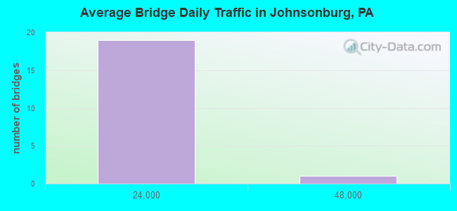
- 82,559Total average daily traffic
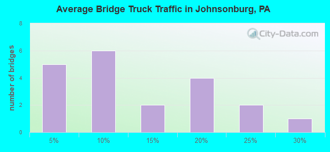
- 15,052Total average daily truck traffic
- National Bridge Inventory (NBI) Registered Bridges for Johnsonburg
- No street view available for this location
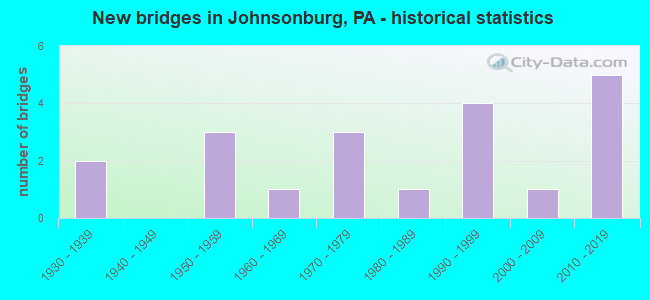
- New bridges - historical statistics
- 21930-1939
- 31950-1959
- 11960-1969
- 31970-1979
- 11980-1989
- 41990-1999
- 12000-2009
- 52010-2019
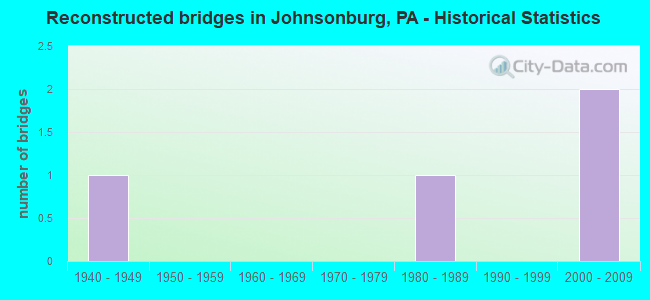
- Reconstructed bridges - Historical Statistics
- 11940-1949
- 01950-1959
- 01960-1969
- 01970-1979
- 11980-1989
- 01990-1999
- 22000-2009
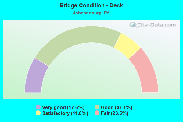
- Bridge Condition - Deck
- 17.6%Very good
- 47.1%Good
- 11.8%Satisfactory
- 23.5%Fair
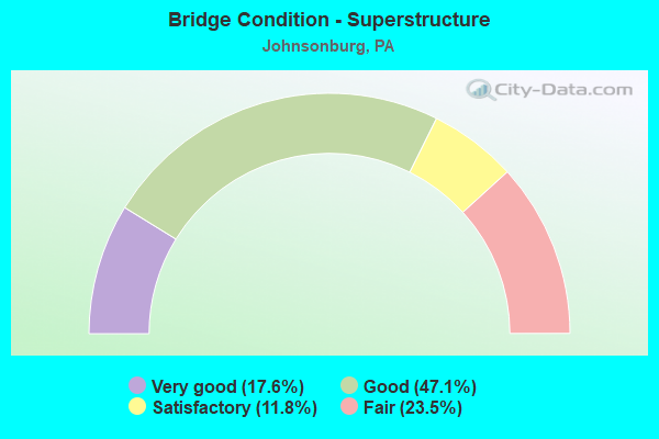
- Bridge Condition - Superstructure
- 17.6%Very good
- 47.1%Good
- 11.8%Satisfactory
- 23.5%Fair
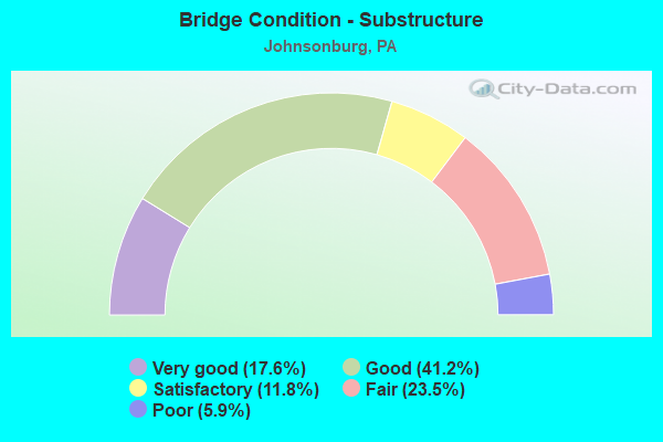
- Bridge Condition - Substructure
- 17.6%Very good
- 41.2%Good
- 11.8%Satisfactory
- 23.5%Fair
- 5.9%Poor
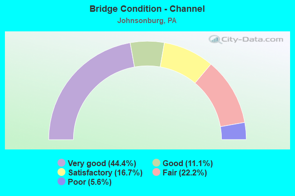
- Bridge Condition - Channel
- 44.4%Very good
- 11.1%Good
- 16.7%Satisfactory
- 22.2%Fair
- 5.6%Poor
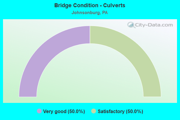
- Bridge Condition - Culverts
- 50.0%Very good
- 50.0%Satisfactory
Find on map >> Show street view
Structure Number: 137, Location: 1.5 MI.E. OF LR 21012 (Lat: 40.257247, Lng: -77.066044), Route carried "on" structure: Interstate 81, Year Built: 1969, Year Reconstructed: 2011, Status: Open, Structure Length: 12.10m (39.70ft), Average Daily Traffic: 36,923 (year 2021), Truck Traffic: 26%, Average Future Daily Traffic: 44,755 (year 2032), Design Load: HS 20, Features Intersected: CONODOGUINET CREEK
Minimum Vertical Clearance: 30+ m (98+ ft), Kilometerpoint: 46.996, Lanes on structure: 2, Base Highway Network: Yes, Owner: State Highway Agency, Approaching Roadway Width: 11.6m (38.1ft), Skew: 11 degrees, Material/Design: Prestressed concrete, Design/Construction: Stringer/Multi-beam, Number Of Spans In Main Unit: 5, Length of Maximum Span: 23.8m (78.1ft), Curb or Sidewalk Widths: Left: 0.2m (0.7ft), Right: 0.2m (0.7ft), Curb-To-Curb Width: 12.0m (39.4ft), Out-to-Out Width: 13.0m (42.7ft)
Condition: Deck: Very good, Superstructure: Fair, Substructure: Satisfactory, Channel: Fair, Operating Rating: 97.1 metric tons, Method Used To Determine Operating Rating: Load Factor (LF), Inventory Rating: 21.8 metric tons, Method Used To Determine Inventory Rating: Load Factor (LF), Structural Evaluation: Somewhat better than minimum adequacy, Deck Geometry: Equal to present minimum criteria, Waterway Adequacy: Superior to present desirable criteria, Approach Roadway Alignment: Equal to present desirable criteria, Length Of Structure Improvement: 13.20m (43.31ft), Designated Inspection Frequency: Every 24 months, Inspection Date: May 2020, Deck Structure Type: Concrete Cast-file-Place, Wearing Surface/Protective System: Wearing Surface: Monolithic Concrete, Deck Protection: Epoxy Coated Reinforcing
Find on map >> Show street view
Structure Number: 15563, Location: JOHNSONBURG BORO (Lat: 41.492358, Lng: -78.677747), Route carried "on" structure: US 219, Year Built: 1959, Status: Open, Structure Length: 3.51m (11.52ft), Average Daily Traffic: 3,186 (year 2020), Truck Traffic: 4%, Average Future Daily Traffic: 4,944 (year 2040), Design Load: HS 20, Features Intersected: EAST BR CLARION RIVER, Facility Carried by Structure: SR 1009
Minimum Vertical Clearance: 30+ m (98+ ft), Kilometerpoint: 0.766, Lanes on structure: 2, Base Highway Network: Yes, Owner: State Highway Agency, Approaching Roadway Width: 9.8m (32.2ft), Material/Design: Steel, Design/Construction: Stringer/Multi-beam, Number Of Spans In Main Unit: 2, Length of Maximum Span: 16.5m (54.1ft), Curb or Sidewalk Widths: Left: 1.5m (4.9ft), Right: 0.5m (1.6ft), Curb-To-Curb Width: 9.8m (32.2ft), Out-to-Out Width: 12.5m (41.0ft)
Condition: Deck: Fair, Superstructure: Fair, Substructure: Fair, Channel: Fair, Operating Rating: 82.6 metric tons, Method Used To Determine Operating Rating: Load Factor (LF), Inventory Rating: 49.0 metric tons, Method Used To Determine Inventory Rating: Load Factor (LF), Structural Evaluation: Somewhat better than minimum adequacy, Deck Geometry: Meets minimum limits, Waterway Adequacy: Equal to present desirable criteria, Approach Roadway Alignment: Equal to present desirable criteria, Length Of Structure Improvement: 3.50m (11.48ft), Designated Inspection Frequency: Every 24 months, Inspection Date: April 2020, Bridge Improvement Cost: $61,000, Roadway Improvement Cost: $250,000, Total Project Cost: $820,000, Deck Structure Type: Concrete Cast-file-Place, Wearing Surface/Protective System: Wearing Surface: Bituminous
Find on map >> Show street view
Structure Number: 15565, Location: JOHNSONBURG BORO (Lat: 41.493906, Lng: -78.680947), Route carried "on" structure: US 219, Year Built: 1992, Status: Open, Structure Length: 3.66m (12.01ft), Average Daily Traffic: 3,186 (year 2020), Truck Traffic: 4%, Average Future Daily Traffic: 4,944 (year 2040), Design Load: H 15, Features Intersected: W BR CLARION RIVER, Facility Carried by Structure: SR 1009
Minimum Vertical Clearance: 30+ m (98+ ft), Kilometerpoint: 1.590, Lanes on structure: 2, Base Highway Network: Yes, Owner: State Highway Agency, Approaching Roadway Width: 9.1m (29.9ft), Material/Design: Prestressed concrete, Design/Construction: Box Beam or Girders - Multiple, Number Of Spans In Main Unit: 1, Length of Maximum Span: 35.1m (115.2ft), Curb or Sidewalk Widths: Left: 1.8m (5.9ft), Right: 0.0m, Curb-To-Curb Width: 9.2m (30.2ft), Out-to-Out Width: 12.1m (39.7ft)
Condition: Deck: Good, Superstructure: Good, Substructure: Good, Channel: Very good, Inventory Rating: 69.9 metric tons, Method Used To Determine Inventory Rating: Load Factor (LF), Structural Evaluation: Better than present minimum criteria, Deck Geometry: Meets minimum limits, Waterway Adequacy: Equal to present desirable criteria, Approach Roadway Alignment: Better than present minimum criteria, Length Of Structure Improvement: 3.70m (12.14ft), Designated Inspection Frequency: Every 24 months, Inspection Date: April 2020, Deck Structure Type: Concrete Cast-file-Place, Wearing Surface/Protective System: Wearing Surface: Monolithic Concrete, Deck Protection: Epoxy Coated Reinforcing
Find on map >> Show street view
Structure Number: 15566, Location: JOHNSONBURG BORO (Lat: 41.494669, Lng: -78.682067), Route carried "on" structure: US 219, Year Built: 1992, Status: Open, Structure Length: 3.66m (12.01ft), Average Daily Traffic: 1,389 (year 2020), Truck Traffic: 11%, Average Future Daily Traffic: 2,397 (year 2040), Design Load: HS 25 or greater, Features Intersected: W BR CLARION RIVER, Facility Carried by Structure: SR 1009
Minimum Vertical Clearance: 30+ m (98+ ft), Kilometerpoint: 1.590, Lanes on structure: 2, Base Highway Network: Yes, Owner: State Highway Agency, Approaching Roadway Width: 9.1m (29.9ft), Skew: 4 degrees, Material/Design: Prestressed concrete, Design/Construction: Box Beam or Girders - Multiple, Number Of Spans In Main Unit: 1, Length of Maximum Span: 34.7m (113.8ft), Curb or Sidewalk Widths: Left: 0.2m (0.7ft), Right: 0.2m (0.7ft), Curb-To-Curb Width: 9.1m (29.9ft), Out-to-Out Width: 10.4m (34.1ft)
Condition: Deck: Good, Superstructure: Good, Substructure: Good, Channel: Very good, Inventory Rating: 64.4 metric tons, Method Used To Determine Inventory Rating: Load Factor (LF), Structural Evaluation: Better than present minimum criteria, Deck Geometry: Somewhat better than minimum adequacy, Waterway Adequacy: Equal to present desirable criteria, Approach Roadway Alignment: Better than present minimum criteria, Length Of Structure Improvement: 3.70m (12.14ft), Designated Inspection Frequency: Every 24 months, Inspection Date: April 2020, Deck Structure Type: Concrete Cast-file-Place, Wearing Surface/Protective System: Wearing Surface: Monolithic Concrete, Deck Protection: Epoxy Coated Reinforcing
Find on map >> Show street view
Structure Number: 15586, Location: 1 MI E JOHNSONBURG (Lat: 41.484203, Lng: -78.648794), Route carried "on" structure: State highway 255, Year Built: 1931, Year Reconstructed: 1953, Status: Open, Structure Length: 1.28m (4.20ft), Average Daily Traffic: 3,895 (year 2021), Truck Traffic: 13%, Average Future Daily Traffic: 4,764 (year 2040), Design Load: H 15, Features Intersected: POWERS RUN
Minimum Vertical Clearance: 30+ m (98+ ft), Kilometerpoint: 35.731, Lanes on structure: 2, Base Highway Network: Yes, Owner: State Highway Agency, Approaching Roadway Width: 8.5m (27.9ft), Skew: 3 degrees, Material/Design: Concrete, Design/Construction: Tee Beam, Number Of Spans In Main Unit: 1, Length of Maximum Span: 12.2m (40.0ft), Curb or Sidewalk Widths: Left: 0.1m (0.3ft), Right: 0.1m (0.3ft), Curb-To-Curb Width: 10.4m (34.1ft), Out-to-Out Width: 11.6m (38.1ft)
Condition: Deck: Fair, Superstructure: Fair, Substructure: Fair, Channel: Fair, Operating Rating: 55.3 metric tons, Method Used To Determine Operating Rating: Allowable Stress (AS), Inventory Rating: 27.2 metric tons, Method Used To Determine Inventory Rating: Allowable Stress (AS), Structural Evaluation: Somewhat better than minimum adequacy, Deck Geometry: Somewhat better than minimum adequacy, Waterway Adequacy: Equal to present desirable criteria, Approach Roadway Alignment: Better than present minimum criteria, Length Of Structure Improvement: 1.30m (4.27ft), Designated Inspection Frequency: Every 24 months, Inspection Date: April 2020, Bridge Improvement Cost: $40,000, Roadway Improvement Cost: $250,000, Total Project Cost: $543,000, Deck Structure Type: Concrete Cast-file-Place, Wearing Surface/Protective System: Wearing Surface: Bituminous
Find on map >> Show street view
Structure Number: 15626, Location: MONTMORENCI (Lat: 41.502728, Lng: -78.742017), Route carried "on" structure: State highway 948, Year Built: 1937, Year Reconstructed: 1986, Status: Open, Structure Length: 1.01m (3.31ft), Average Daily Traffic: 1,059 (year 2022), Truck Traffic: 22%, Average Future Daily Traffic: 1,681 (year 2040), Design Load: H 20, Features Intersected: LITTLE MILL CREEK
Minimum Vertical Clearance: 30+ m (98+ ft), Kilometerpoint: 22.268, Lanes on structure: 2, Base Highway Network: Yes, Owner: State Highway Agency, Approaching Roadway Width: 8.5m (27.9ft), Material/Design: Prestressed concrete, Design/Construction: Box Beam or Girders - Single/Spread, Number Of Spans In Main Unit: 1, Length of Maximum Span: 9.1m (29.9ft), Curb or Sidewalk Widths: Left: 0.2m (0.7ft), Right: 0.2m (0.7ft), Curb-To-Curb Width: 9.1m (29.9ft), Out-to-Out Width: 10.2m (33.5ft)
Condition: Deck: Satisfactory, Superstructure: Good, Substructure: Satisfactory, Channel: Satisfactory, Operating Rating: 62.6 metric tons, Method Used To Determine Operating Rating: Load Factor (LF), Inventory Rating: 31.8 metric tons, Method Used To Determine Inventory Rating: Load Factor (LF), Structural Evaluation: Equal to present minimum criteria, Deck Geometry: Somewhat better than minimum adequacy, Waterway Adequacy: Equal to present minimum criteria, Approach Roadway Alignment: Better than present minimum criteria, Length Of Structure Improvement: 1.00m (3.28ft), Designated Inspection Frequency: Every 24 months, Inspection Date: April 2020, Deck Structure Type: Concrete Cast-file-Place, Wearing Surface/Protective System: Wearing Surface: Monolithic Concrete, Deck Protection: Epoxy Coated Reinforcing
Find on map >> Show street view
Structure Number: 15627, Location: 2 MI N MONTMORENCI (Lat: 41.513703, Lng: -78.749506), Route carried "on" structure: State highway 948, Year Built: 1951, Status: Open, Structure Length: 1.01m (3.31ft), Average Daily Traffic: 1,059 (year 2022), Truck Traffic: 22%, Average Future Daily Traffic: 1,681 (year 2040), Design Load: HS 20, Features Intersected: LITTLE MILL CREEK
Minimum Vertical Clearance: 30+ m (98+ ft), Kilometerpoint: 23.770, Lanes on structure: 2, Base Highway Network: Yes, Owner: State Highway Agency, Approaching Roadway Width: 7.3m (24.0ft), Skew: 3 degrees, Material/Design: Steel, Design/Construction: Stringer/Multi-beam, Number Of Spans In Main Unit: 1, Length of Maximum Span: 9.8m (32.2ft), Curb or Sidewalk Widths: Left: 0.2m (0.7ft), Right: 0.2m (0.7ft), Curb-To-Curb Width: 9.1m (29.9ft), Out-to-Out Width: 9.8m (32.2ft)
Condition: Deck: Satisfactory, Superstructure: Fair, Substructure: Poor, Channel: Poor, Operating Rating: 56.2 metric tons, Method Used To Determine Operating Rating: Load Factor (LF), Inventory Rating: 33.6 metric tons, Method Used To Determine Inventory Rating: Load Factor (LF), Structural Evaluation: Meets minimum limits, Deck Geometry: Somewhat better than minimum adequacy, Waterway Adequacy: Equal to present minimum criteria, Approach Roadway Alignment: Equal to present desirable criteria, Length Of Structure Improvement: 1.00m (3.28ft), Designated Inspection Frequency: Every 24 months, Inspection Date: April 2020, Bridge Improvement Cost: $32,000, Roadway Improvement Cost: $250,000, Total Project Cost: $435,000, Deck Structure Type: Concrete Cast-file-Place, Wearing Surface/Protective System: Wearing Surface: Bituminous
Find on map >> Show street view
Structure Number: 15718, Location: 3 MI N JOHNSONBURG (Lat: 41.533067, Lng: -78.685761), Route carried "on" structure: State highway , Year Built: 1989, Status: Open, Structure Length: 4.60m (15.09ft), Average Daily Traffic: 598 (year 2020), Truck Traffic: 2%, Average Future Daily Traffic: 990 (year 2040), Design Load: HS 25 or greater, Features Intersected: WEST BRANCH CLARION R., Facility Carried by Structure: SR 4003
Minimum Vertical Clearance: 30+ m (98+ ft), Kilometerpoint: 6.851, Lanes on structure: 2, Owner: State Highway Agency, Approaching Roadway Width: 7.0m (23.0ft), Material/Design: Steel, Design/Construction: Stringer/Multi-beam, Number Of Spans In Main Unit: 1, Length of Maximum Span: 45.7m (149.9ft), Curb or Sidewalk Widths: Left: 0.2m (0.7ft), Right: 0.2m (0.7ft), Curb-To-Curb Width: 10.4m (34.1ft), Out-to-Out Width: 11.4m (37.4ft)
Condition: Deck: Good, Superstructure: Good, Substructure: Good, Channel: Very good, Operating Rating: 93.4 metric tons, Method Used To Determine Operating Rating: Load Factor (LF), Inventory Rating: 56.2 metric tons, Method Used To Determine Inventory Rating: Load Factor (LF), Structural Evaluation: Better than present minimum criteria, Deck Geometry: Equal to present minimum criteria, Waterway Adequacy: Equal to present desirable criteria, Approach Roadway Alignment: Equal to present minimum criteria, Length Of Structure Improvement: 4.60m (15.09ft), Designated Inspection Frequency: Every 24 months, Inspection Date: April 2020, Deck Structure Type: Concrete Cast-file-Place, Wearing Surface/Protective System: Wearing Surface: Monolithic Concrete, Deck Protection: Epoxy Coated Reinforcing
Find on map >> Show street view
Structure Number: 15721, Location: JOHNSONBURG BORO (Lat: 41.499269, Lng: -78.683747), Route carried "on" structure: State highway , Year Built: 1957, Year Reconstructed: 2011, Status: Open, Structure Length: 0.94m (3.08ft), Average Daily Traffic: 1,974 (year 2020), Truck Traffic: 2%, Average Future Daily Traffic: 3,065 (year 2040), Design Load: HS 20, Features Intersected: SILVER CREEK, Facility Carried by Structure: SR 4005
Minimum Vertical Clearance: 30+ m (98+ ft), Kilometerpoint: 0.000, Lanes on structure: 2, Owner: State Highway Agency, Approaching Roadway Width: 9.8m (32.2ft), Material/Design: Prestressed concrete, Design/Construction: Box Beam or Girders - Multiple, Number Of Spans In Main Unit: 1, Length of Maximum Span: 9.1m (29.9ft), Curb or Sidewalk Widths: Left: 1.5m (4.9ft), Right: 1.5m (4.9ft), Curb-To-Curb Width: 9.9m (32.5ft), Out-to-Out Width: 13.0m (42.7ft)
Condition: Deck: Good, Superstructure: Satisfactory, Substructure: Fair, Channel: Good, Inventory Rating: 64.4 metric tons, Method Used To Determine Inventory Rating: Load Factor (LF), Structural Evaluation: Somewhat better than minimum adequacy, Deck Geometry: Somewhat better than minimum adequacy, Waterway Adequacy: Superior to present desirable criteria, Approach Roadway Alignment: Equal to present desirable criteria, Length Of Structure Improvement: 0.90m (2.95ft), Designated Inspection Frequency: Every 24 months, Inspection Date: April 2020, Bridge Improvement Cost: $29,000, Roadway Improvement Cost: $250,000, Total Project Cost: $393,000, Deck Structure Type: Concrete Cast-file-Place, Wearing Surface/Protective System: Wearing Surface: Monolithic Concrete, Deck Protection: Epoxy Coated Reinforcing
Find on map >> Show street view
Structure Number: 15724, Location: JOHNSONBURG BORO (Lat: 41.498608, Lng: -78.681236), Route carried "on" structure: State highway , Year Built: 1974, Status: Open, Structure Length: 2.50m (8.20ft), Average Daily Traffic: 2,504 (year 2022), Truck Traffic: 5%, Average Future Daily Traffic: 2,403 (year 2040), Design Load: HS 20, Features Intersected: W BRANCH CLARION RIVER, Facility Carried by Structure: SR 4007
Minimum Vertical Clearance: 30+ m (98+ ft), Kilometerpoint: 0.000, Lanes on structure: 2, Owner: State Highway Agency, Approaching Roadway Width: 8.5m (27.9ft), Material/Design: Prestressed concrete, Design/Construction: Box Beam or Girders - Multiple, Number Of Spans In Main Unit: 1, Length of Maximum Span: 24.7m (81.0ft), Curb or Sidewalk Widths: Left: 0.2m (0.7ft), Right: 0.2m (0.7ft), Curb-To-Curb Width: 13.4m (44.0ft), Out-to-Out Width: 14.6m (47.9ft)
Condition: Deck: Fair, Superstructure: Satisfactory, Substructure: Good, Channel: Very good, Operating Rating: 76.2 metric tons, Method Used To Determine Operating Rating: Load Factor (LF), Inventory Rating: 21.8 metric tons, Method Used To Determine Inventory Rating: Load Factor (LF), Structural Evaluation: Somewhat better than minimum adequacy, Deck Geometry: Better than present minimum criteria, Waterway Adequacy: Equal to present desirable criteria, Approach Roadway Alignment: Equal to present desirable criteria, Length Of Structure Improvement: 2.50m (8.20ft), Designated Inspection Frequency: Every 24 months, Inspection Date: April 2020, Bridge Improvement Cost: $31,000, Roadway Improvement Cost: $250,000, Total Project Cost: $420,000, Deck Structure Type: Concrete Cast-file-Place, Wearing Surface/Protective System: Wearing Surface: Monolithic Concrete
Find on map >> Show street view
Structure Number: 15727, Location: JOHNSONBURG BORO (Lat: 41.502544, Lng: -78.689014), Route carried "on" structure: State highway , Year Built: 1970, Status: Open, Structure Length: 1.16m (3.81ft), Average Daily Traffic: 465 (year 2020), Truck Traffic: 8%, Average Future Daily Traffic: 782 (year 2040), Design Load: HS 20, Features Intersected: SILVER CREEK, Facility Carried by Structure: SR 4007
Minimum Vertical Clearance: 30+ m (98+ ft), Kilometerpoint: 0.602, Lanes on structure: 2, Owner: State Highway Agency, Approaching Roadway Width: 9.1m (29.9ft), Skew: 2 degrees, Material/Design: Prestressed concrete, Design/Construction: Box Beam or Girders - Single/Spread, Number Of Spans In Main Unit: 1, Length of Maximum Span: 11.0m (36.1ft), Curb or Sidewalk Widths: Left: 0.3m (1.0ft), Right: 0.3m (1.0ft), Curb-To-Curb Width: 13.4m (44.0ft), Out-to-Out Width: 14.6m (47.9ft)
Condition: Deck: Fair, Superstructure: Good, Substructure: Fair, Channel: Fair, Operating Rating: 66.2 metric tons, Method Used To Determine Operating Rating: Load Factor (LF), Inventory Rating: 30.8 metric tons, Method Used To Determine Inventory Rating: Load Factor (LF), Structural Evaluation: Somewhat better than minimum adequacy, Deck Geometry: Superior to present desirable criteria, Waterway Adequacy: Equal to present desirable criteria, Approach Roadway Alignment: Equal to present minimum criteria, Length Of Structure Improvement: 1.20m (3.94ft), Designated Inspection Frequency: Every 24 months, Inspection Date: April 2020, Bridge Improvement Cost: $35,000, Roadway Improvement Cost: $250,000, Total Project Cost: $474,000, Deck Structure Type: Concrete Cast-file-Place, Wearing Surface/Protective System: Wearing Surface: Bituminous
Find on map >> Show street view
Structure Number: 15728, Location: 1 MI NW JOHNSONBURG (Lat: 41.512639, Lng: -78.688711), Route carried "on" structure: State highway , Year Built: 1970, Status: Open, Structure Length: 0.85m (2.79ft), Average Daily Traffic: 465 (year 2020), Truck Traffic: 8%, Average Future Daily Traffic: 782 (year 2040), Design Load: HS 20, Features Intersected: SILVER CREEK, Facility Carried by Structure: SR 4007
Minimum Vertical Clearance: 30+ m (98+ ft), Kilometerpoint: 2.020, Lanes on structure: 2, Owner: State Highway Agency, Approaching Roadway Width: 8.5m (27.9ft), Skew: 3 degrees, Material/Design: Concrete, Design/Construction: Slab, Number Of Spans In Main Unit: 1, Length of Maximum Span: 7.9m (25.9ft), Curb or Sidewalk Widths: Left: 0.2m (0.7ft), Right: 0.2m (0.7ft), Curb-To-Curb Width: 12.8m (42.0ft), Out-to-Out Width: 14.0m (45.9ft)
Condition: Deck: Good, Superstructure: Good, Substructure: Good, Channel: Satisfactory, Operating Rating: 53.5 metric tons, Method Used To Determine Operating Rating: Load Factor (LF), Inventory Rating: 31.8 metric tons, Method Used To Determine Inventory Rating: Load Factor (LF), Structural Evaluation: Better than present minimum criteria, Deck Geometry: Superior to present desirable criteria, Waterway Adequacy: Equal to present desirable criteria, Approach Roadway Alignment: Equal to present desirable criteria, Length Of Structure Improvement: 0.90m (2.95ft), Designated Inspection Frequency: Every 24 months, Inspection Date: April 2020, Bridge Improvement Cost: $27,000, Roadway Improvement Cost: $246,000, Total Project Cost: $360,000, Wearing Surface/Protective System: Wearing Surface: Bituminous
Find on map >> Show street view
Structure Number: 15772, Location: 900 FT S OF INT SR 219 (Lat: 41.486300, Lng: -78.678300), Route carried "on" structure: ServiceCity street , Year Built: 1994, Status: Open, Structure Length: 4.30m (14.11ft), Average Daily Traffic: 1,239 (year 2021), Truck Traffic: 6%, Average Future Daily Traffic: 1,735 (year 2041), Design Load: HS 25 or greater, Features Intersected: CLARION RIVER, Facility Carried by Structure: GRANT STREET
Minimum Vertical Clearance: 30+ m (98+ ft), Kilometerpoint: 0.000, Lanes on structure: 2, Owner: Town or Township Highway Agency, Approaching Roadway Width: 8.5m (27.9ft), Material/Design: Prestressed concrete, Design/Construction: Stringer/Multi-beam, Number Of Spans In Main Unit: 1, Length of Maximum Span: 41.5m (136.2ft), Curb or Sidewalk Widths: Left: 0.2m (0.7ft), Right: 1.5m (4.9ft), Curb-To-Curb Width: 8.5m (27.9ft), Out-to-Out Width: 10.9m (35.8ft)
Condition: Deck: Good, Superstructure: Good, Substructure: Good, Channel: Good, Operating Rating: 96.2 metric tons, Method Used To Determine Operating Rating: Load Factor (LF), Inventory Rating: 35.4 metric tons, Method Used To Determine Inventory Rating: Load Factor (LF), Structural Evaluation: Better than present minimum criteria, Deck Geometry: Somewhat better than minimum adequacy, Waterway Adequacy: Superior to present desirable criteria, Approach Roadway Alignment: Better than present minimum criteria, Length Of Structure Improvement: 5.20m (17.06ft), Designated Inspection Frequency: Every 24 months, Inspection Date: November 2021, Deck Structure Type: Concrete Cast-file-Place, Wearing Surface/Protective System: Wearing Surface: Monolithic Concrete, Deck Protection: Epoxy Coated Reinforcing
Find on map >> Show street view
Structure Number: 40605, Location: WATER ST. EXTENSION (Lat: 41.501300, Lng: -78.728800), Route carried "on" structure: City street , Year Built: 1999, Status: Open, Structure Length: 0.61m (2.00ft), Average Daily Traffic: 681 (year 2021), Truck Traffic: 5%, Average Future Daily Traffic: 874 (year 2041), Design Load: HS 25 or greater, Features Intersected: LITTLE MILL CREEK, Facility Carried by Structure: T-351, Water St Ex
Minimum Vertical Clearance: 30+ m (98+ ft), Kilometerpoint: 0.000, Lanes on structure: 2, Toll: Toll bridge, Owner: Town or Township Highway Agency, Approaching Roadway Width: 5.5m (18.0ft), Material/Design: Concrete, Design/Construction: Culvert, Number Of Spans In Main Unit: 1, Length of Maximum Span: 6.1m (20.0ft), Curb-To-Curb Width: 8.9m (29.2ft), Out-to-Out Width: 10.1m (33.1ft)
Condition: Channel: Satisfactory, Culverts: Satisfactory, Operating Rating: 49.0 metric tons, Method Used To Determine Operating Rating: Field evaluation and documented engineering judgment, Inventory Rating: 32.7 metric tons, Method Used To Determine Inventory Rating: Field evaluation and documented engineering judgment, Structural Evaluation: Equal to present minimum criteria, Deck Geometry: Somewhat better than minimum adequacy, Waterway Adequacy: Meets minimum limits, Approach Roadway Alignment: Equal to present desirable criteria, Length Of Structure Improvement: 1.20m (3.94ft), Designated Inspection Frequency: Every 24 months, Inspection Date: September 2021
Find on map >> Show street view
Structure Number: 44152, Location: JOHNSONBURG (Lat: 41.491778, Lng: -78.676889), Route carried "on" structure: US 219, Year Built: 2007, Status: Open, Structure Length: 21.21m (69.59ft), Average Daily Traffic: 5,808 (year 2020), Truck Traffic: 17%, Average Future Daily Traffic: 6,134 (year 2040), Design Load: HL 93, Features Intersected: CLARION RIVER/ B & P RR
Minimum Vertical Clearance: 30+ m (98+ ft), Kilometerpoint: 35.457, Lanes on structure: 2, Base Highway Network: Yes, Owner: State Highway Agency, Approaching Roadway Width: 13.4m (44.0ft), Skew: 9 degrees, Material/Design: Prestressed concrete continuous, Design/Construction: Stringer/Multi-beam, Number Of Spans In Main Unit: 6, Length of Maximum Span: 39.9m (130.9ft), Curb or Sidewalk Widths: Left: 0.2m (0.7ft), Right: 0.2m (0.7ft), Curb-To-Curb Width: 13.4m (44.0ft), Out-to-Out Width: 14.4m (47.2ft)
Condition: Deck: Good, Superstructure: Good, Substructure: Good, Channel: Very good, Operating Rating: 91.6 metric tons, Method Used To Determine Operating Rating: Load Factor (LF), Inventory Rating: 33.6 metric tons, Method Used To Determine Inventory Rating: Load Factor (LF), Structural Evaluation: Better than present minimum criteria, Deck Geometry: Equal to present minimum criteria, Underclear: High priority of corrective action, Waterway Adequacy: Superior to present desirable criteria, Approach Roadway Alignment: Better than present minimum criteria, Designated Inspection Frequency: Every 24 months, Inspection Date: April 2020, Deck Structure Type: Concrete Cast-file-Place, Wearing Surface/Protective System: Wearing Surface: Monolithic Concrete, Deck Protection: Epoxy Coated Reinforcing
Find on map >> Show street view
Structure Number: 46072, Location: JOHNSONBURG BORO (Lat: 41.495000, Lng: -78.683333), Route carried "on" structure: US 219, Year Built: 2010, Status: Open, Structure Length: 28.80m (94.49ft), Average Daily Traffic: 5,808 (year 2020), Truck Traffic: 17%, Average Future Daily Traffic: 6,134 (year 2040), Design Load: HL 93, Features Intersected: CLARION R&W.CENTER ST&RR
Minimum Vertical Clearance: 30+ m (98+ ft), Kilometerpoint: 37.105, Lanes on structure: 2, Lanes under structure: 2, Base Highway Network: Yes, Owner: State Highway Agency, Approaching Roadway Width: 13.4m (44.0ft), Material/Design: Prestressed concrete continuous, Design/Construction: Stringer/Multi-beam, Number Of Spans In Main Unit: 8, Length of Maximum Span: 46.3m (151.9ft), Curb or Sidewalk Widths: Left: 0.2m (0.7ft), Right: 0.2m (0.7ft), Curb-To-Curb Width: 13.4m (44.0ft), Out-to-Out Width: 14.4m (47.2ft)
Condition: Deck: Good, Superstructure: Very good, Substructure: Very good, Channel: Very good, Operating Rating: 80.7 metric tons, Method Used To Determine Operating Rating: Load Factor (LF), Inventory Rating: 35.4 metric tons, Method Used To Determine Inventory Rating: Load Factor (LF), Structural Evaluation: Equal to present desirable criteria, Deck Geometry: Equal to present minimum criteria, Underclear: High priority of corrective action, Waterway Adequacy: Superior to present desirable criteria, Approach Roadway Alignment: Better than present minimum criteria, Designated Inspection Frequency: Every 24 months, Inspection Date: May 2020, Deck Structure Type: Concrete Cast-file-Place, Wearing Surface/Protective System: Wearing Surface: Monolithic Concrete, Deck Protection: Epoxy Coated Reinforcing
Find on map >> Show street view
Structure Number: 46074, Location: JOHNSONBURG BORO (Lat: 41.491667, Lng: -78.668889), Route carried "on" structure: US 219, Year Built: 2010, Status: Open, Structure Length: 36.88m (121.00ft), Average Daily Traffic: 5,808 (year 2020), Truck Traffic: 17%, Average Future Daily Traffic: 6,134 (year 2040), Design Load: HL 93, Features Intersected: B&P RAILROAD/JOHNSON RUN
Minimum Vertical Clearance: 30+ m (98+ ft), Kilometerpoint: 36.193, Lanes on structure: 2, Base Highway Network: Yes, Owner: State Highway Agency, Approaching Roadway Width: 13.4m (44.0ft), Material/Design: Steel, Design/Construction: Stringer/Multi-beam, Number Of Spans In Main Unit: 8, Length of Maximum Span: 85.3m (279.9ft), Curb or Sidewalk Widths: Left: 0.2m (0.7ft), Right: 0.2m (0.7ft), Curb-To-Curb Width: 13.4m (44.0ft), Out-to-Out Width: 14.4m (47.2ft)
Condition: Deck: Very good, Superstructure: Very good, Substructure: Very good, Operating Rating: 72.6 metric tons, Method Used To Determine Operating Rating: Load and Resistance Factor (LRFR), Inventory Rating: 38.1 metric tons, Method Used To Determine Inventory Rating: Load and Resistance Factor (LRFR), Structural Evaluation: Equal to present desirable criteria, Deck Geometry: Equal to present minimum criteria, Underclear: High priority of corrective action, Approach Roadway Alignment: Equal to present desirable criteria, Designated Inspection Frequency: Every 24 months, Inspection Date: May 2020, Deck Structure Type: Concrete Cast-file-Place, Wearing Surface/Protective System: Wearing Surface: Monolithic Concrete, Deck Protection: Epoxy Coated Reinforcing
Find on map >> Show street view
Structure Number: 48716, Location: 2 MI NE MONTMORENCI (Lat: 41.517189, Lng: -78.719394), Route carried "on" structure: State highway , Year Built: 2014, Status: Open, Structure Length: 0.64m (2.10ft), Average Daily Traffic: 565 (year 2020), Truck Traffic: 8%, Average Future Daily Traffic: 683 (year 2040), Design Load: HL 93, Features Intersected: SILVER CREEK, Facility Carried by Structure: SR 4003
Minimum Vertical Clearance: 30+ m (98+ ft), Kilometerpoint: 3.129, Lanes on structure: 2, Owner: State Highway Agency, Approaching Roadway Width: 7.0m (23.0ft), Skew: 1 degrees, Material/Design: Concrete, Design/Construction: Culvert, Number Of Spans In Main Unit: 1, Length of Maximum Span: 6.4m (21.0ft), Curb-To-Curb Width: 7.3m (24.0ft), Out-to-Out Width: 8.3m (27.2ft)
Condition: Channel: Very good, Culverts: Very good, Operating Rating: 56.4 metric tons, Method Used To Determine Operating Rating: Assigned ratings based on Load and Resistance Factor Design (LRFD) reported by rating factor (RF) using HL93 loadings, Inventory Rating: 35.3 metric tons, Method Used To Determine Inventory Rating: Assigned ratings based on Load and Resistance Factor Design (LRFD) reported by rating factor (RF) using HL93 loadings, Structural Evaluation: Equal to present desirable criteria, Deck Geometry: Meets minimum limits, Waterway Adequacy: Equal to present desirable criteria, Approach Roadway Alignment: Equal to present desirable criteria, Designated Inspection Frequency: Every 24 months, Inspection Date: April 2020
Find on map >> Show street view
Structure Number: 53776, Location: JOHNSONBURG (Lat: 41.479967, Lng: -78.670083), Route carried "on" structure: US 219, Year Built: 2017, Status: Open, Structure Length: 2.62m (8.60ft), Average Daily Traffic: 3,973 (year 2022), Truck Traffic: 17%, Average Future Daily Traffic: 4,402 (year 2037), Design Load: HL 93, Features Intersected: Powers Run
Minimum Vertical Clearance: 30+ m (98+ ft), Kilometerpoint: 35.089, Lanes on structure: 2, Base Highway Network: Yes, Owner: State Highway Agency, Maintenance Responsibility: Private, Approaching Roadway Width: 10.1m (33.1ft), Skew: 4 degrees, Material/Design: Prestressed concrete, Design/Construction: Box Beam or Girders - Single/Spread, Number Of Spans In Main Unit: 1, Length of Maximum Span: 24.7m (81.0ft), Curb-To-Curb Width: 12.8m (42.0ft), Out-to-Out Width: 13.4m (44.0ft)
Condition: Deck: Very good, Superstructure: Very good, Substructure: Very good, Channel: Very good, Operating Rating: 50.5 metric tons, Method Used To Determine Operating Rating: Assigned ratings based on Load and Resistance Factor Design (LRFD) reported by rating factor (RF) using HL93 loadings, Inventory Rating: 39.2 metric tons, Method Used To Determine Inventory Rating: Assigned ratings based on Load and Resistance Factor Design (LRFD) reported by rating factor (RF) using HL93 loadings, Structural Evaluation: Equal to present desirable criteria, Deck Geometry: Equal to present minimum criteria, Waterway Adequacy: Equal to present minimum criteria, Approach Roadway Alignment: Equal to present desirable criteria, Designated Inspection Frequency: Every 24 months, Inspection Date: June 2021, Deck Structure Type: Concrete Cast-file-Place, Wearing Surface/Protective System: Wearing Surface: Integral Concrete, Deck Protection: Epoxy Coated Reinforcing
Find on map >> Show street view
Structure Number: 46072, Location: JOHNSONBURG BORO (Lat: 41.495000, Lng: -78.683333), Route carried "under" structure: State highway , Year Built: 2010, Structure Length: 0. m, Average Daily Traffic: 1,974 (year 2020), Truck Traffic: 2%, Features Intersected: CLARION R&W.CENTER ST&RR, Facility Carried by Structure: SR 219 US 219
Minimum Vertical Clearance: 13.07m (42.88ft), Kilometerpoint: 0.000, Lanes on structure: 2, Lanes under structure: 2, Material/Design: Prestressed concrete continuous, Design/Construction: Stringer/Multi-beam, Length of Maximum Span: 46.3m (151.9ft)