Bridge Statistics for Joseph City, Arizona (AZ)
Condition, Traffic, Stress, Structural Evaluation, Project Costs
- National Bridge Inventory (NBI) Statistics
- 17Number of bridges
- 223ft / 68.4mTotal length
- $5,000Total costs
- 172,576Total average daily traffic
- 61,763Total average daily truck traffic
- National Bridge Inventory (NBI) Registered Bridges for Joseph City
- No street view available for this location
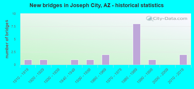
- New bridges - historical statistics
- 11910-1919
- 11920-1929
- 11940-1949
- 11950-1959
- 21960-1969
- 81980-1989
- 11990-1999
- 22010-2019
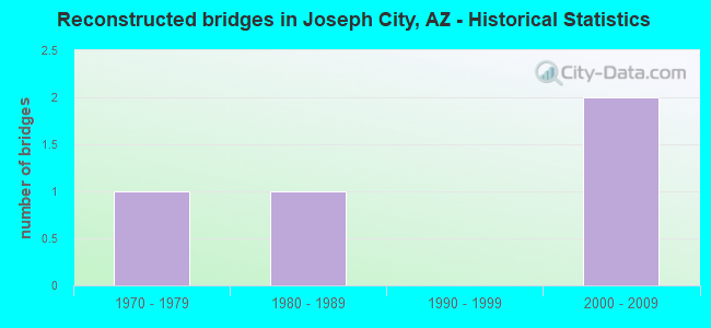
- Reconstructed bridges - Historical Statistics
- 11970-1979
- 11980-1989
- 01990-1999
- 22000-2009
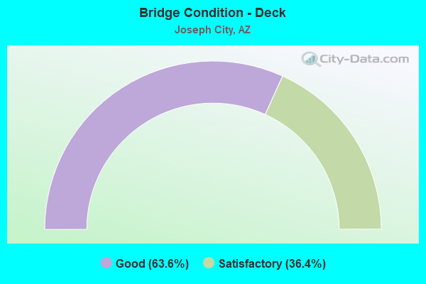
- Bridge Condition - Deck
- 63.6%Good
- 36.4%Satisfactory
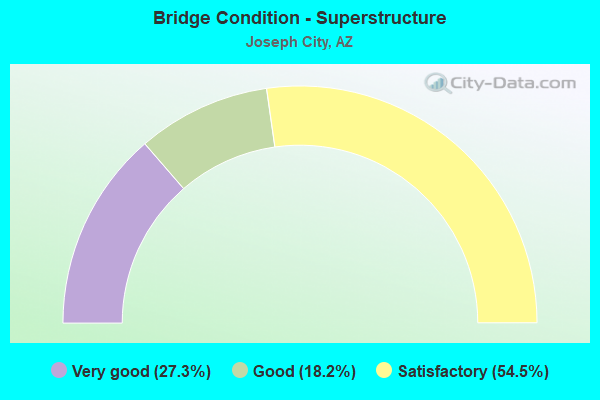
- Bridge Condition - Superstructure
- 27.3%Very good
- 18.2%Good
- 54.5%Satisfactory
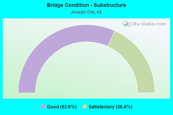
- Bridge Condition - Substructure
- 63.6%Good
- 36.4%Satisfactory
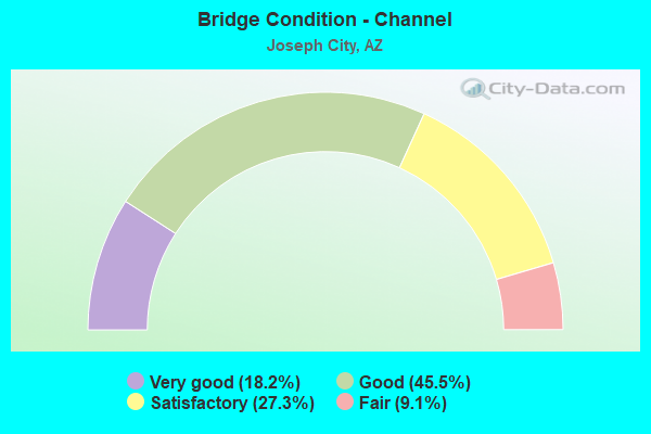
- Bridge Condition - Channel
- 18.2%Very good
- 45.5%Good
- 27.3%Satisfactory
- 9.1%Fair
Find on map >> Show street view
Structure Number: 1893, Location: 17.0 mi E Jct SR 87 (Lat: 34.955800, Lng: -110.351400), Route carried "on" structure: Business State highway 40, Year Built: 1980, Status: Open, Structure Length: 7.83m (25.69ft), Average Daily Traffic: 760 (year 2021), Truck Traffic: 21%, Average Future Daily Traffic: 770 (year 2041), Design Load: HS 20, Features Intersected: I-40
Minimum Vertical Clearance: 30+ m (98+ ft), Kilometerpoint: 441.926, Lanes on structure: 2, Lanes under structure: 4, Owner: State Highway Agency, Approaching Roadway Width: 10.4m (34.1ft), Material/Design: Prestressed concrete continuous, Design/Construction: Box Beam or Girders - Single/Spread, Number Of Spans In Main Unit: 2, Length of Maximum Span: 38.7m (127.0ft), Curb-To-Curb Width: 11.6m (38.1ft), Out-to-Out Width: 12.6m (41.3ft)
Condition: Deck: Satisfactory, Superstructure: Satisfactory, Substructure: Good, Operating Rating: 72.6 metric tons, Method Used To Determine Operating Rating: Load Factor (LF), Inventory Rating: 42.6 metric tons, Method Used To Determine Inventory Rating: Load Factor (LF), Structural Evaluation: Equal to present minimum criteria, Deck Geometry: Better than present minimum criteria, Underclear: Somewhat better than minimum adequacy, Approach Roadway Alignment: Equal to present desirable criteria, Designated Inspection Frequency: Every 24 months, Inspection Date: May 2021, Deck Structure Type: Concrete Cast-file-Place, Wearing Surface/Protective System: Wearing Surface: Other
Find on map >> Show street view
Structure Number: 1894, Location: 17.3 mi E Jct SR 87 (Lat: 34.954400, Lng: -110.341000), Route carried "on" structure: Interstate 40, Year Built: 1980, Status: Open, Structure Length: 3.96m (12.99ft), Average Daily Traffic: 12,636 (year 2021), Truck Traffic: 43%, Average Future Daily Traffic: 12,646 (year 2041), Design Load: HS 20, Features Intersected: Joseph City Wash
Minimum Vertical Clearance: 30+ m (98+ ft), Kilometerpoint: 443.117, Lanes on structure: 2, Owner: State Highway Agency, Approaching Roadway Width: 11.6m (38.1ft), Material/Design: Concrete continuous, Design/Construction: Slab, Number Of Spans In Main Unit: 4, Length of Maximum Span: 10.7m (35.1ft), Curb-To-Curb Width: 12.8m (42.0ft), Out-to-Out Width: 13.8m (45.3ft)
Condition: Deck: Good, Superstructure: Good, Substructure: Satisfactory, Channel: Good, Operating Rating: 89.8 metric tons, Method Used To Determine Operating Rating: Load Factor (LF), Inventory Rating: 62.6 metric tons, Method Used To Determine Inventory Rating: Load Factor (LF), Structural Evaluation: Equal to present minimum criteria, Deck Geometry: Equal to present desirable criteria, Waterway Adequacy: Equal to present desirable criteria, Approach Roadway Alignment: Equal to present desirable criteria, Designated Inspection Frequency: Every 24 months, Inspection Date: May 2021, Deck Structure Type: Concrete Cast-file-Place, Wearing Surface/Protective System: Wearing Surface: Monolithic Concrete
Find on map >> Show street view
Structure Number: 1895, Location: 17.3 mi E Jct SR 87 (Lat: 34.954800, Lng: -110.341000), Route carried "on" structure: Interstate 40, Year Built: 1980, Status: Open, Structure Length: 3.96m (12.99ft), Average Daily Traffic: 10,538 (year 2021), Truck Traffic: 43%, Average Future Daily Traffic: 10,548 (year 2041), Design Load: HS 20, Features Intersected: Joseph City Wash
Minimum Vertical Clearance: 30+ m (98+ ft), Kilometerpoint: 443.117, Lanes on structure: 2, Owner: State Highway Agency, Approaching Roadway Width: 11.6m (38.1ft), Material/Design: Concrete continuous, Design/Construction: Slab, Number Of Spans In Main Unit: 4, Length of Maximum Span: 10.7m (35.1ft), Curb-To-Curb Width: 12.8m (42.0ft), Out-to-Out Width: 13.8m (45.3ft)
Condition: Deck: Satisfactory, Superstructure: Satisfactory, Substructure: Satisfactory, Channel: Good, Operating Rating: 89.8 metric tons, Method Used To Determine Operating Rating: Load Factor (LF), Inventory Rating: 62.6 metric tons, Method Used To Determine Inventory Rating: Load Factor (LF), Structural Evaluation: Equal to present minimum criteria, Deck Geometry: Equal to present desirable criteria, Waterway Adequacy: Equal to present desirable criteria, Approach Roadway Alignment: Equal to present desirable criteria, Designated Inspection Frequency: Every 24 months, Inspection Date: May 2021, Deck Structure Type: Concrete Cast-file-Place, Wearing Surface/Protective System: Wearing Surface: Monolithic Concrete
Find on map >> Show street view
Structure Number: 1896, Location: 17.9 mi E Jct SR 87 (Lat: 34.954000, Lng: -110.331400), Route carried "on" structure: County highway , Year Built: 1980, Status: Open, Structure Length: 7.80m (25.59ft), Average Daily Traffic: 1,210 (year 2021), Truck Traffic: 2%, Average Future Daily Traffic: 1,220 (year 2041), Design Load: HS 20, Features Intersected: I-40, Facility Carried by Structure: Westover Ave
Minimum Vertical Clearance: 30+ m (98+ ft), Kilometerpoint: 0.000, Lanes on structure: 2, Lanes under structure: 4, Owner: State Highway Agency, Approaching Roadway Width: 8.5m (27.9ft), Material/Design: Prestressed concrete continuous, Design/Construction: Box Beam or Girders - Single/Spread, Number Of Spans In Main Unit: 2, Length of Maximum Span: 38.7m (127.0ft), Curb-To-Curb Width: 8.5m (27.9ft), Out-to-Out Width: 9.5m (31.2ft)
Condition: Deck: Good, Superstructure: Satisfactory, Substructure: Good, Operating Rating: 71.7 metric tons, Method Used To Determine Operating Rating: Load Factor (LF), Inventory Rating: 34.5 metric tons, Method Used To Determine Inventory Rating: Load Factor (LF), Structural Evaluation: Equal to present minimum criteria, Deck Geometry: Somewhat better than minimum adequacy, Underclear: Better than present minimum criteria, Approach Roadway Alignment: Equal to present desirable criteria, Designated Inspection Frequency: Every 24 months, Inspection Date: June 2021, Deck Structure Type: Concrete Cast-file-Place, Wearing Surface/Protective System: Wearing Surface: Other
Find on map >> Show street view
Structure Number: 1897, Location: 19.3 mi E Jct SR 87 (Lat: 34.952300, Lng: -110.311000), Route carried "on" structure: Business Interstate 40, Year Built: 1980, Status: Open, Structure Length: 7.83m (25.69ft), Average Daily Traffic: 18,001 (year 2020), Truck Traffic: 46%, Average Future Daily Traffic: 18,011 (year 2040), Design Load: HS 20, Features Intersected: I-40
Minimum Vertical Clearance: 30.45m (99.90ft), Kilometerpoint: 445.917, Lanes on structure: 2, Lanes under structure: 4, Owner: State Highway Agency, Approaching Roadway Width: 10.4m (34.1ft), Material/Design: Prestressed concrete continuous, Design/Construction: Box Beam or Girders - Single/Spread, Number Of Spans In Main Unit: 2, Length of Maximum Span: 38.7m (127.0ft), Curb-To-Curb Width: 11.6m (38.1ft), Out-to-Out Width: 12.6m (41.3ft)
Condition: Deck: Satisfactory, Superstructure: Satisfactory, Substructure: Good, Operating Rating: 72.6 metric tons, Method Used To Determine Operating Rating: Load Factor (LF), Inventory Rating: 41.7 metric tons, Method Used To Determine Inventory Rating: Load Factor (LF), Structural Evaluation: Equal to present minimum criteria, Deck Geometry: Somewhat better than minimum adequacy, Underclear: Better than present minimum criteria, Approach Roadway Alignment: Equal to present desirable criteria, Designated Inspection Frequency: Every 24 months, Inspection Date: May 2021, Deck Structure Type: Concrete Cast-file-Place, Wearing Surface/Protective System: Wearing Surface: Other
Find on map >> Show street view
Structure Number: 208, Location: 13.9 mi E Jct SR 87 (Lat: 34.964300, Lng: -110.408400), Route carried "on" structure: ServiceState highway 40, Year Built: 1949, Status: Open, Structure Length: 2.32m (7.61ft), Average Daily Traffic: 210 (year 2021), Truck Traffic: 5%, Average Future Daily Traffic: 220 (year 2041), Design Load: HS 20, Features Intersected: Manila Wash
Minimum Vertical Clearance: 30+ m (98+ ft), Kilometerpoint: 436.889, Lanes on structure: 2, Owner: State Highway Agency, Approaching Roadway Width: 12.2m (40.0ft), Material/Design: Concrete, Design/Construction: Tee Beam, Number Of Spans In Main Unit: 2, Length of Maximum Span: 11.3m (37.1ft), Curb or Sidewalk Widths: Left: 0.5m (1.6ft), Right: 0.5m (1.6ft), Curb-To-Curb Width: 12.2m (40.0ft), Out-to-Out Width: 13.7m (44.9ft)
Condition: Deck: Satisfactory, Superstructure: Satisfactory, Substructure: Satisfactory, Channel: Satisfactory, Operating Rating: 42.6 metric tons, Method Used To Determine Operating Rating: Load Factor (LF), Inventory Rating: 25.4 metric tons, Method Used To Determine Inventory Rating: Load Factor (LF), Structural Evaluation: Equal to present minimum criteria, Deck Geometry: Superior to present desirable criteria, Waterway Adequacy: Equal to present desirable criteria, Approach Roadway Alignment: Equal to present minimum criteria, Designated Inspection Frequency: Every 24 months, Inspection Date: May 2021, Deck Structure Type: Concrete Cast-file-Place, Wearing Surface/Protective System: Wearing Surface: Bituminous
Find on map >> Show street view
Structure Number: 2428, Location: 0.82 mi E Jct I-40 (Lat: 34.956300, Lng: -110.341200), Route carried "on" structure: Business State highway 40, Year Built: 1996, Status: Open, Structure Length: 3.35m (10.99ft), Average Daily Traffic: 686 (year 2021), Truck Traffic: 15%, Average Future Daily Traffic: 696 (year 2041), Design Load: HS 20, Features Intersected: St Joseph Wash
Minimum Vertical Clearance: 30+ m (98+ ft), Kilometerpoint: 443.246, Lanes on structure: 2, Owner: State Highway Agency, Approaching Roadway Width: 12.2m (40.0ft), Material/Design: Concrete continuous, Design/Construction: Slab, Number Of Spans In Main Unit: 5, Length of Maximum Span: 6.7m (22.0ft), Curb-To-Curb Width: 13.4m (44.0ft), Out-to-Out Width: 14.4m (47.2ft)
Condition: Deck: Good, Superstructure: Good, Substructure: Good, Channel: Good, Operating Rating: 64.4 metric tons, Method Used To Determine Operating Rating: Load Factor (LF), Inventory Rating: 38.1 metric tons, Method Used To Determine Inventory Rating: Load Factor (LF), Structural Evaluation: Better than present minimum criteria, Deck Geometry: Superior to present desirable criteria, Waterway Adequacy: Equal to present desirable criteria, Approach Roadway Alignment: Equal to present desirable criteria, Designated Inspection Frequency: Every 24 months, Inspection Date: June 2021, Deck Structure Type: Concrete Cast-file-Place, Wearing Surface/Protective System: Wearing Surface: Monolithic Concrete
Find on map >> Show street view
Structure Number: 2925, Location: 14.8 mi W Jct SR 77 (Lat: 34.946500, Lng: -110.295600), Route carried "on" structure: Interstate 40, Year Built: 2010, Status: Open, Structure Length: 4.36m (14.30ft), Average Daily Traffic: 9,576 (year 2020), Truck Traffic: 34%, Average Future Daily Traffic: 9,576 (year 2040), Design Load: HS 20, Features Intersected: Tanner Wash
Minimum Vertical Clearance: 30+ m (98+ ft), Kilometerpoint: 447.446, Lanes on structure: 2, Owner: State Highway Agency, Approaching Roadway Width: 12.8m (42.0ft), Skew: 3 degrees, Material/Design: Concrete continuous, Design/Construction: Slab, Number Of Spans In Main Unit: 6, Length of Maximum Span: 7.6m (24.9ft), Curb-To-Curb Width: 12.8m (42.0ft), Out-to-Out Width: 13.7m (44.9ft)
Condition: Deck: Good, Superstructure: Very good, Substructure: Good, Channel: Very good, Operating Rating: 89.8 metric tons, Method Used To Determine Operating Rating: Load Factor (LF), Inventory Rating: 72.6 metric tons, Method Used To Determine Inventory Rating: Load Factor (LF), Structural Evaluation: Better than present minimum criteria, Deck Geometry: Equal to present desirable criteria, Waterway Adequacy: Equal to present desirable criteria, Approach Roadway Alignment: Equal to present desirable criteria, Designated Inspection Frequency: Every 24 months, Inspection Date: June 2021, Deck Structure Type: Concrete Cast-file-Place, Wearing Surface/Protective System: Wearing Surface: Monolithic Concrete
Find on map >> Show street view
Structure Number: 4264, Location: 15.3 mi E Jct SR 87 (Lat: 34.960686, Lng: -110.379356), Route carried "on" structure: Interstate 40, Year Built: 1965, Year Reconstructed: 1980, Status: Open, Structure Length: 0.98m (3.22ft), Average Daily Traffic: 17,426 (year 2017), Truck Traffic: 24%, Average Future Daily Traffic: 17,436 (year 2039), Design Load: HS 20, Features Intersected: Wash
Minimum Vertical Clearance: 30+ m (98+ ft), Kilometerpoint: 439.528, Lanes on structure: 6, Owner: State Highway Agency, Approaching Roadway Width: 31.7m (104.0ft), Material/Design: Concrete continuous, Design/Construction: Culvert, Number Of Spans In Main Unit: 3, Length of Maximum Span: 3.0m (9.8ft)
Condition: Channel: Good, Culverts: Good, Operating Rating: 63.5 metric tons, Method Used To Determine Operating Rating: Load Factor (LF), Inventory Rating: 38.1 metric tons, Method Used To Determine Inventory Rating: Load Factor (LF), Structural Evaluation: Better than present minimum criteria, Waterway Adequacy: Equal to present desirable criteria, Approach Roadway Alignment: Equal to present desirable criteria, Length Of Structure Improvement: 1.74m (5.71ft), Designated Inspection Frequency: Every 48 months, Inspection Date: April 2019, Bridge Improvement Cost: $1,000, Roadway Improvement Cost: $1,000, Total Project Cost: $2,000 ( Estimate for 2019)
Find on map >> Show street view
Structure Number: 5853, Location: 20.5 mi East Jct SR 95 (Lat: 34.936800, Lng: -114.148600), Route carried "on" structure: Interstate 40, Year Built: 1965, Status: Open, Structure Length: 1.98m (6.50ft), Average Daily Traffic: 8,186 (year 2014), Truck Traffic: 37%, Average Future Daily Traffic: 8,196 (year 2036), Design Load: HS 20, Features Intersected: Wash
Minimum Vertical Clearance: 30+ m (98+ ft), Kilometerpoint: 48.763, Lanes on structure: 2, Owner: State Highway Agency, Approaching Roadway Width: 11.6m (38.1ft), Material/Design: Concrete continuous, Design/Construction: Culvert, Number Of Spans In Main Unit: 6, Length of Maximum Span: 3.0m (9.8ft)
Condition: Channel: Satisfactory, Culverts: Good, Operating Rating: 63.5 metric tons, Method Used To Determine Operating Rating: Load Factor (LF), Inventory Rating: 38.1 metric tons, Method Used To Determine Inventory Rating: Load Factor (LF), Structural Evaluation: Better than present minimum criteria, Waterway Adequacy: Equal to present minimum criteria, Approach Roadway Alignment: Equal to present desirable criteria, Designated Inspection Frequency: Every 48 months, Inspection Date: June 2020
Find on map >> Show street view
Structure Number: 5977, Location: 12.8 mi W Jct SR 77 (Lat: 34.928956, Lng: -110.269283), Route carried "on" structure: Interstate 40, Year Built: 1954, Year Reconstructed: 1981, Status: Open, Structure Length: 0.98m (3.22ft), Average Daily Traffic: 18,798 (year 2017), Truck Traffic: 24%, Average Future Daily Traffic: 18,808 (year 2039), Design Load: HS 20, Features Intersected: Wash
Minimum Vertical Clearance: 30+ m (98+ ft), Kilometerpoint: 450.584, Lanes on structure: 4, Owner: State Highway Agency, Approaching Roadway Width: 23.2m (76.1ft), Skew: 20 degrees, Material/Design: Concrete continuous, Design/Construction: Culvert, Number Of Spans In Main Unit: 3, Length of Maximum Span: 3.0m (9.8ft)
Condition: Channel: Good, Culverts: Good, Operating Rating: 57.2 metric tons, Method Used To Determine Operating Rating: Load Factor (LF), Inventory Rating: 33.6 metric tons, Method Used To Determine Inventory Rating: Load Factor (LF), Structural Evaluation: Better than present minimum criteria, Waterway Adequacy: Equal to present desirable criteria, Approach Roadway Alignment: Equal to present desirable criteria, Length Of Structure Improvement: 1.74m (5.71ft), Designated Inspection Frequency: Every 48 months, Inspection Date: May 2019, Bridge Improvement Cost: $1,000, Total Project Cost: $2,000 ( Estimate for 2019)
Find on map >> Show street view
Structure Number: 8157, Location: 1.33 mi S Jct Old US 66 (Lat: 34.940500, Lng: -110.323900), Route carried "on" structure: County highway , Year Built: 1912, Year Reconstructed: 2011, Status: Open, Structure Length: 15.27m (50.10ft), Average Daily Traffic: 160 (year 2016), Truck Traffic: 3%, Average Future Daily Traffic: 170 (year 2036), Design Load: HS 20, Features Intersected: Little Colorado River, Facility Carried by Structure: Obed Rd
Minimum Vertical Clearance: 30+ m (98+ ft), Kilometerpoint: 0.000, Lanes on structure: 1, Owner: County Highway Agency, Approaching Roadway Width: 4.0m (13.1ft), Material/Design: Steel, Design/Construction: Truss - Thru, Number Of Spans In Main Unit: 6, Length of Maximum Span: 26.5m (86.9ft), Curb or Sidewalk Widths: Left: 0.2m (0.7ft), Right: 0.2m (0.7ft), Curb-To-Curb Width: 3.9m (12.8ft), Out-to-Out Width: 4.3m (14.1ft)
Condition: Deck: Good, Superstructure: Very good, Substructure: Good, Channel: Fair, Operating Rating: 51.7 metric tons, Method Used To Determine Operating Rating: Allowable Stress (AS), Inventory Rating: 35.4 metric tons, Method Used To Determine Inventory Rating: Allowable Stress (AS), Structural Evaluation: Better than present minimum criteria, Deck Geometry: High priority of replacement, Waterway Adequacy: Equal to present desirable criteria, Approach Roadway Alignment: Superior to present desirable criteria, Length Of Structure Improvement: 16.06m (52.69ft), Designated Inspection Frequency: Every 24 months, Critical Feature Inspection Frequency: Every 24 months, Inspection Date: May 2020, Critical Feature Inspection Date: May 2020, Total Project Cost: $1,000 ( Estimate for 2020), Deck Structure Type: Concrete Cast-file-Place, Wearing Surface/Protective System: Wearing Surface: Monolithic Concrete
Find on map >> Show street view
Structure Number: 816, Location: 1.3 mi SE Jct B 40 (Lat: 34.945150, Lng: -110.299611), Route carried "on" structure: County highway , Year Built: 1926, Year Reconstructed: 2008, Status: Open, Structure Length: 3.38m (11.09ft), Average Daily Traffic: 200 (year 2020), Truck Traffic: 5%, Average Future Daily Traffic: 210 (year 2040), Design Load: HS 20, Features Intersected: Tanner Wash, Facility Carried by Structure: Cholla Lake Road
Minimum Vertical Clearance: 30+ m (98+ ft), Kilometerpoint: 0.000, Lanes on structure: 2, Owner: County Highway Agency, Approaching Roadway Width: 8.5m (27.9ft), Material/Design: Concrete, Design/Construction: Tee Beam, Number Of Spans In Main Unit: 4, Length of Maximum Span: 11.6m (38.1ft), Curb-To-Curb Width: 8.5m (27.9ft), Out-to-Out Width: 9.4m (30.8ft)
Condition: Deck: Good, Superstructure: Satisfactory, Substructure: Satisfactory, Channel: Satisfactory, Operating Rating: 40.8 metric tons, Method Used To Determine Operating Rating: Load Factor (LF), Inventory Rating: 24.5 metric tons, Method Used To Determine Inventory Rating: Load Factor (LF), Structural Evaluation: Equal to present minimum criteria, Deck Geometry: Equal to present minimum criteria, Waterway Adequacy: Equal to present desirable criteria, Approach Roadway Alignment: Equal to present desirable criteria, Designated Inspection Frequency: Every 24 months, Inspection Date: May 2020, Deck Structure Type: Concrete Cast-file-Place, Wearing Surface/Protective System: Wearing Surface: Bituminous
Find on map >> Show street view
Structure Number: 20102, Location: 14.8 mi W jct SR 77 (Lat: 34.946400, Lng: -110.296100), Route carried "on" structure: Interstate 40, Year Built: 2016, Status: Open, Structure Length: 4.36m (14.30ft), Average Daily Traffic: 11,572 (year 2021), Truck Traffic: 42%, Average Future Daily Traffic: 11,582 (year 2041), Design Load: HL 93, Features Intersected: I-40
Minimum Vertical Clearance: 30+ m (98+ ft), Kilometerpoint: 447.630, Lanes on structure: 2, Owner: State Highway Agency, Approaching Roadway Width: 12.8m (42.0ft), Skew: 3 degrees, Material/Design: Concrete continuous, Design/Construction: Slab, Number Of Spans In Main Unit: 6, Length of Maximum Span: 7.6m (24.9ft), Curb-To-Curb Width: 12.8m (42.0ft), Out-to-Out Width: 13.7m (44.9ft)
Condition: Deck: Good, Superstructure: Very good, Substructure: Good, Channel: Very good, Operating Rating: 89.8 metric tons, Method Used To Determine Operating Rating: Load Factor (LF), Inventory Rating: 76.2 metric tons, Method Used To Determine Inventory Rating: Load Factor (LF), Structural Evaluation: Better than present minimum criteria, Deck Geometry: Equal to present desirable criteria, Waterway Adequacy: Equal to present desirable criteria, Approach Roadway Alignment: Equal to present desirable criteria, Designated Inspection Frequency: Every 24 months, Inspection Date: June 2021, Deck Structure Type: Concrete Cast-file-Place, Wearing Surface/Protective System: Wearing Surface: Monolithic Concrete
Find on map >> Show street view
Structure Number: 1893, Location: 17.0 mi E Jct SR 87 (Lat: 34.955800, Lng: -110.351400), Route carried "under" structure: Interstate 40, Year Built: 1980, Structure Length: 0. m, Average Daily Traffic: 20,765 (year 2019), Truck Traffic: 43%, Features Intersected: I-40
Minimum Vertical Clearance: 5.04m (16.54ft), Kilometerpoint: 442.183, Lanes on structure: 2, Lanes under structure: 2, Material/Design: Prestressed concrete continuous, Design/Construction: Box Beam or Girders - Single/Spread, Length of Maximum Span: 38.7m (127.0ft)
Find on map >> Show street view
Structure Number: 1896, Location: 17.9 mi E Jct SR 87 (Lat: 34.954000, Lng: -110.331400), Route carried "under" structure: Interstate 40, Year Built: 1980, Structure Length: 0. m, Average Daily Traffic: 23,174 (year 2021), Truck Traffic: 43%, Features Intersected: I-40, Facility Carried by Structure: Westover Ave
Minimum Vertical Clearance: 5.33m (17.49ft), Kilometerpoint: 444.002, Lanes on structure: 2, Lanes under structure: 2, Material/Design: Prestressed concrete continuous, Design/Construction: Box Beam or Girders - Single/Spread, Length of Maximum Span: 38.7m (127.0ft)
Find on map >> Show street view
Structure Number: 1897, Location: 19.3 mi E Jct SR 87 (Lat: 34.952300, Lng: -110.311000), Route carried "under" structure: Interstate 40, Year Built: 1980, Structure Length: 0. m, Average Daily Traffic: 18,678 (year 2017), Truck Traffic: 24%, Features Intersected: I-40
Minimum Vertical Clearance: 5.57m (18.27ft), Kilometerpoint: 445.917, Lanes on structure: 2, Lanes under structure: 2, Material/Design: Prestressed concrete continuous, Design/Construction: Box Beam or Girders - Single/Spread, Length of Maximum Span: 38.7m (127.0ft)