Bridge Statistics for Kanopolis, Kansas (KS)
Condition, Traffic, Stress, Structural Evaluation, Project Costs
- National Bridge Inventory (NBI) Statistics
- 18Number of bridges
- 105ft / 31.8mTotal length
- $225,000Total costs
- 5,727Total average daily traffic
- 771Total average daily truck traffic
- 8,719Total future (year 2040) average daily traffic
- National Bridge Inventory (NBI) Registered Bridges for Kanopolis
- No street view available for this location
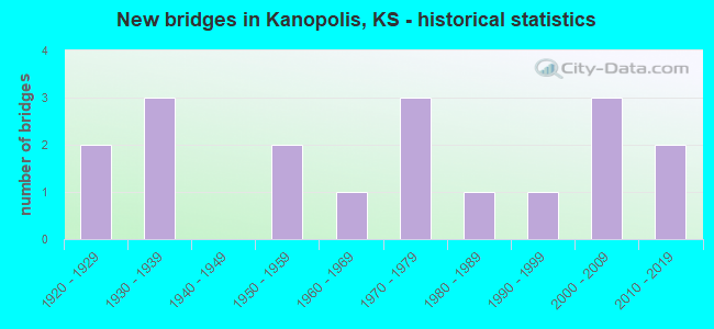
- New bridges - historical statistics
- 21920-1929
- 31930-1939
- 21950-1959
- 11960-1969
- 31970-1979
- 11980-1989
- 11990-1999
- 32000-2009
- 22010-2019

- Bridge Condition - Deck
- 18.2%Very good
- 54.5%Good
- 27.3%Satisfactory
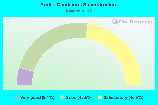
- Bridge Condition - Superstructure
- 9.1%Very good
- 45.5%Good
- 45.5%Satisfactory

- Bridge Condition - Substructure
- 9.1%Very good
- 45.5%Good
- 45.5%Satisfactory
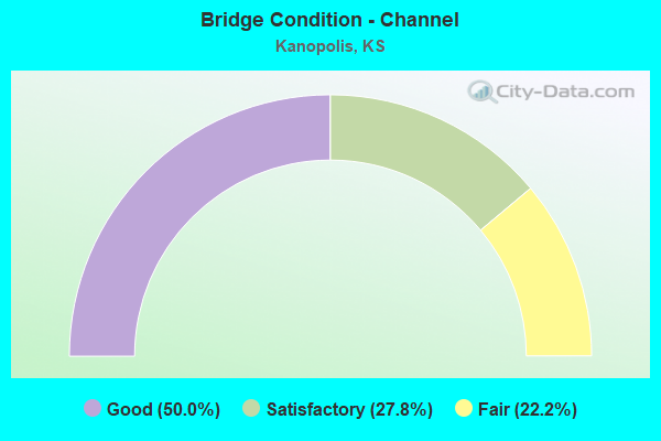
- Bridge Condition - Channel
- 50.0%Good
- 27.8%Satisfactory
- 22.2%Fair
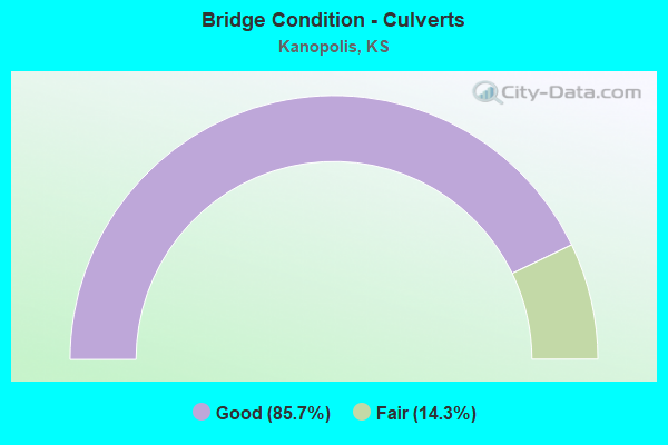
- Bridge Condition - Culverts
- 85.7%Good
- 14.3%Fair
Find on map >> Show street view
Structure Number: 16033, Location: 3.0S 2.5E OF HALLS SUMMIT (Lat: 38.303008, Lng: -95.627856), Route carried "on" structure: County highway 153, Year Built: 1978, Status: Open, Structure Length: 3.44m (11.29ft), Average Daily Traffic: 27 (year 2013), Average Future Daily Traffic: 33 (year 2040), Design Load: H 20, Features Intersected: LONG CREEK, Facility Carried by Structure: 19TH. RD. #56
Minimum Vertical Clearance: 30.47m (99.97ft), Kilometerpoint: 1.630, Lanes on structure: 2, Owner: County Highway Agency, Approaching Roadway Width: 7.0m (23.0ft), Material/Design: Concrete continuous, Design/Construction: Slab, Number Of Spans In Main Unit: 3, Length of Maximum Span: 13.4m (44.0ft), Curb-To-Curb Width: 7.9m (25.9ft), Out-to-Out Width: 8.5m (27.9ft)
Condition: Deck: Good, Superstructure: Very good, Substructure: Very good, Channel: Fair, Operating Rating: 48.6 metric tons, Method Used To Determine Operating Rating: No rating analysis performed, Inventory Rating: 29.7 metric tons, Method Used To Determine Inventory Rating: No rating analysis performed, Structural Evaluation: Better than present minimum criteria, Deck Geometry: Equal to present minimum criteria, Waterway Adequacy: Better than present minimum criteria, Approach Roadway Alignment: Equal to present desirable criteria, Designated Inspection Frequency: Every 24 months, Inspection Date: April 2020, Other Special Inspection Date: November 2021, Deck Structure Type: Concrete Cast-file-Place
Find on map >> Show street view
Structure Number: 27015, Location: 1.4W OF KANOPOLIS (Lat: 38.710792, Lng: -98.182208), Route carried "on" structure: County highway 238, Year Built: 1951, Status: Posted for load, Structure Length: 0.67m (2.20ft), Average Daily Traffic: 960 (year 2017), Truck Traffic: 10%, Average Future Daily Traffic: 1,150 (year 2040), Design Load: H 15, Features Intersected: TRIB. TO SPRING CREEK, Facility Carried by Structure: L Road
Minimum Vertical Clearance: 30.47m (99.97ft), Kilometerpoint: 0.000, Lanes on structure: 2, Owner: County Highway Agency, Approaching Roadway Width: 7.1m (23.3ft), Material/Design: Concrete, Design/Construction: Culvert, Number Of Spans In Main Unit: 3, Length of Maximum Span: 2.4m (7.9ft), Curb or Sidewalk Widths: Left: 0.3m (1.0ft), Right: 0.3m (1.0ft), Curb-To-Curb Width: 8.5m (27.9ft), Out-to-Out Width: 9.1m (29.9ft)
Condition: Channel: Satisfactory, Culverts: Good, Operating Rating: 33.5 metric tons, Method Used To Determine Operating Rating: Load Factor (LF), Inventory Rating: 20.0 metric tons, Method Used To Determine Inventory Rating: Load Factor (LF), Structural Evaluation: Somewhat better than minimum adequacy, Deck Geometry: Somewhat better than minimum adequacy, Waterway Adequacy: Equal to present minimum criteria, Approach Roadway Alignment: Better than present minimum criteria, Bridge Posting: Required (Relationship of Operating Rating to Maximum Legal Load: 10.0 - 19.9% below), Designated Inspection Frequency: Every 24 months, Inspection Date: March 2020, Deck Structure Type: Concrete Cast-file-Place, Wearing Surface/Protective System: Wearing Surface: Bituminous
Find on map >> Show street view
Structure Number: 27018, Location: 1.5S 1.5E OF KANOPOLIS (Lat: 38.689336, Lng: -98.129389), Route carried "on" structure: County highway 238, Year Built: 1994, Status: Open, Structure Length: 8.84m (29.00ft), Average Daily Traffic: 135 (year 2017), Truck Traffic: 10%, Average Future Daily Traffic: 160 (year 2040), Design Load: HS 20, Features Intersected: SMOKY HILL RIVER, Facility Carried by Structure: N Road
Minimum Vertical Clearance: 30.47m (99.97ft), Kilometerpoint: 0.000, Lanes on structure: 2, Owner: County Highway Agency, Approaching Roadway Width: 7.3m (24.0ft), Material/Design: Concrete continuous, Design/Construction: Slab, Number Of Spans In Main Unit: 5, Length of Maximum Span: 19.7m (64.6ft), Curb or Sidewalk Widths: Left: 0.3m (1.0ft), Right: 0.3m (1.0ft), Curb-To-Curb Width: 8.5m (27.9ft), Out-to-Out Width: 9.1m (29.9ft)
Condition: Deck: Good, Superstructure: Good, Substructure: Good, Channel: Good, Operating Rating: 43.2 metric tons, Method Used To Determine Operating Rating: Allowable Stress (AS), Inventory Rating: 32.4 metric tons, Method Used To Determine Inventory Rating: Allowable Stress (AS), Structural Evaluation: Better than present minimum criteria, Deck Geometry: Equal to present minimum criteria, Waterway Adequacy: Equal to present minimum criteria, Approach Roadway Alignment: Better than present minimum criteria, Designated Inspection Frequency: Every 24 months, Inspection Date: March 2020, Deck Structure Type: Concrete Cast-file-Place, Wearing Surface/Protective System: Wearing Surface: Monolithic Concrete
Find on map >> Show street view
Structure Number: 27019, Location: 2.1S 2.3E OF KANOPOLIS (Lat: 38.681639, Lng: -98.110061), Route carried "on" structure: County highway 238, Year Built: 1984, Status: Open, Structure Length: 2.13m (6.99ft), Average Daily Traffic: 110 (year 2017), Truck Traffic: 10%, Average Future Daily Traffic: 132 (year 2040), Features Intersected: TRIB. SMOKY HILL RIVER, Facility Carried by Structure: 21st Road
Minimum Vertical Clearance: 30.47m (99.97ft), Kilometerpoint: 0.000, Lanes on structure: 2, Owner: County Highway Agency, Approaching Roadway Width: 6.0m (19.7ft), Material/Design: Steel continuous, Design/Construction: Stringer/Multi-beam, Number Of Spans In Main Unit: 2, Length of Maximum Span: 10.5m (34.4ft), Curb-To-Curb Width: 9.1m (29.9ft), Out-to-Out Width: 9.1m (29.9ft)
Condition: Deck: Good, Superstructure: Satisfactory, Substructure: Satisfactory, Channel: Satisfactory, Operating Rating: 66.2 metric tons, Method Used To Determine Operating Rating: Load Factor (LF), Inventory Rating: 39.6 metric tons, Method Used To Determine Inventory Rating: Load Factor (LF), Structural Evaluation: Equal to present minimum criteria, Deck Geometry: Equal to present minimum criteria, Waterway Adequacy: Equal to present minimum criteria, Approach Roadway Alignment: Better than present minimum criteria, Designated Inspection Frequency: Every 24 months, Inspection Date: August 2020, Other Special Inspection Date: August 2020, Deck Structure Type: Corrugated Steel, Wearing Surface/Protective System: Wearing Surface: Gravel
Find on map >> Show street view
Structure Number: 27045, Location: 1.4E OF KANOPOLIS (Lat: 38.711833, Lng: -98.132517), Route carried "on" structure: County highway 1002, Year Built: 2003, Status: Open, Structure Length: 0.96m (3.15ft), Average Daily Traffic: 185 (year 2017), Truck Traffic: 10%, Average Future Daily Traffic: 220 (year 2040), Design Load: HS 20, Features Intersected: TRIB. SMOKY HILL RIVER, Facility Carried by Structure: 20th Road
Minimum Vertical Clearance: 30.47m (99.97ft), Kilometerpoint: 0.000, Lanes on structure: 2, Owner: County Highway Agency, Approaching Roadway Width: 7.3m (24.0ft), Material/Design: Concrete, Design/Construction: Culvert, Number Of Spans In Main Unit: 3, Length of Maximum Span: 3.1m (10.2ft), Curb or Sidewalk Widths: Left: 0.2m (0.7ft), Right: 0.2m (0.7ft), Curb-To-Curb Width: 17.8m (58.4ft), Out-to-Out Width: 18.3m (60.0ft)
Condition: Channel: Good, Culverts: Good, Operating Rating: 43.2 metric tons, Method Used To Determine Operating Rating: Load Factor (LF), Inventory Rating: 32.4 metric tons, Method Used To Determine Inventory Rating: Load Factor (LF), Structural Evaluation: Better than present minimum criteria, Deck Geometry: Superior to present desirable criteria, Waterway Adequacy: Equal to present minimum criteria, Approach Roadway Alignment: Better than present minimum criteria, Designated Inspection Frequency: Every 24 months, Inspection Date: March 2020, Deck Structure Type: Concrete Cast-file-Place, Wearing Surface/Protective System: Wearing Surface: Bituminous
Find on map >> Show street view
Structure Number: 27B16, Location: .9 W of Kanapolis (Lat: 38.710733, Lng: -98.171417), Route carried "on" structure: County highway 238, Year Built: 2015, Status: Open, Structure Length: 2.23m (7.32ft), Average Daily Traffic: 960 (year 2017), Truck Traffic: 10%, Average Future Daily Traffic: 1,150 (year 2040), Design Load: HS 20, Features Intersected: SPRING CREEK, Facility Carried by Structure: L Road
Minimum Vertical Clearance: 30.47m (99.97ft), Kilometerpoint: 0.000, Lanes on structure: 2, Owner: County Highway Agency, Approaching Roadway Width: 18.2m (59.7ft), Skew: 4 degrees, Material/Design: Concrete, Design/Construction: Culvert, Number Of Spans In Main Unit: 3, Length of Maximum Span: 7.0m (23.0ft), Curb or Sidewalk Widths: Left: 0.3m (1.0ft), Right: 0.3m (1.0ft), Curb-To-Curb Width: 18.3m (60.0ft), Out-to-Out Width: 18.9m (62.0ft)
Condition: Channel: Good, Culverts: Good, Operating Rating: 41.8 metric tons, Method Used To Determine Operating Rating: Load and Resistance Factor (LRFR), Inventory Rating: 32.3 metric tons, Method Used To Determine Inventory Rating: Load and Resistance Factor (LRFR), Structural Evaluation: Better than present minimum criteria, Deck Geometry: Superior to present desirable criteria, Waterway Adequacy: Equal to present desirable criteria, Approach Roadway Alignment: Better than present minimum criteria, Designated Inspection Frequency: Every 24 months, Inspection Date: March 2020, Deck Structure Type: Concrete Cast-file-Place, Wearing Surface/Protective System: Wearing Surface: Gravel
Find on map >> Show street view
Structure Number: 270729004823, Location: 1.5W 2.3S OF KANOPOLIS (Lat: 38.678789, Lng: -98.183544), Route carried "on" structure: County highway , Year Built: 1975, Status: Open, Structure Length: 1.23m (4.04ft), Average Daily Traffic: 25 (year 2014), Truck Traffic: 5%, Average Future Daily Traffic: 30 (year 2040), Design Load: H 15, Features Intersected: MUD CREEK, Facility Carried by Structure: 17th Road
Minimum Vertical Clearance: 30.47m (99.97ft), Kilometerpoint: 0.000, Lanes on structure: 2, Owner: County Highway Agency, Approaching Roadway Width: 6.0m (19.7ft), Material/Design: Prestressed concrete, Design/Construction: Tee Beam, Number Of Spans In Main Unit: 1, Length of Maximum Span: 11.6m (38.1ft), Curb-To-Curb Width: 7.5m (24.6ft), Out-to-Out Width: 7.7m (25.3ft)
Condition: Deck: Good, Superstructure: Good, Substructure: Good, Channel: Good, Operating Rating: 32.4 metric tons, Method Used To Determine Operating Rating: Allowable Stress (AS), Inventory Rating: 24.3 metric tons, Method Used To Determine Inventory Rating: Allowable Stress (AS), Structural Evaluation: Equal to present minimum criteria, Deck Geometry: Equal to present minimum criteria, Waterway Adequacy: Equal to present minimum criteria, Approach Roadway Alignment: Better than present minimum criteria, Designated Inspection Frequency: Every 24 months, Inspection Date: March 2020, Deck Structure Type: Concrete Precast Panels, Wearing Surface/Protective System: Wearing Surface: Gravel
Find on map >> Show street view
Structure Number: 27072910486, Location: 1.4W 4.0S OF KANOPOLIS (Lat: 38.652881, Lng: -98.182028), Route carried "on" structure: County highway , Year Built: 1971, Status: Open, Structure Length: 3.12m (10.24ft), Average Daily Traffic: 50 (year 2014), Truck Traffic: 5%, Average Future Daily Traffic: 55 (year 2040), Design Load: H 15, Features Intersected: ASH CREEK, Facility Carried by Structure: P Road
Minimum Vertical Clearance: 30.47m (99.97ft), Kilometerpoint: 0.000, Lanes on structure: 2, Owner: County Highway Agency, Approaching Roadway Width: 5.4m (17.7ft), Material/Design: Concrete continuous, Design/Construction: Slab, Number Of Spans In Main Unit: 3, Length of Maximum Span: 12.2m (40.0ft), Curb-To-Curb Width: 8.5m (27.9ft), Out-to-Out Width: 9.1m (29.9ft)
Condition: Deck: Good, Superstructure: Good, Substructure: Satisfactory, Channel: Fair, Operating Rating: 37.7 metric tons, Method Used To Determine Operating Rating: Load Factor (LF), Inventory Rating: 22.6 metric tons, Method Used To Determine Inventory Rating: Load Factor (LF), Structural Evaluation: Equal to present minimum criteria, Deck Geometry: Better than present minimum criteria, Waterway Adequacy: Equal to present minimum criteria, Approach Roadway Alignment: Better than present minimum criteria, Designated Inspection Frequency: Every 24 months, Inspection Date: August 2020, Other Special Inspection Date: August 2020, Deck Structure Type: Concrete Cast-file-Place, Wearing Surface/Protective System: Wearing Surface: Gravel
Find on map >> Show street view
Structure Number: 27073100488, Location: 0.5W 5.0S OF KANOPOLIS (Lat: 38.638908, Lng: -98.164894), Route carried "on" structure: County highway , Year Built: 1930, Status: Posted for load, Structure Length: 0.84m (2.76ft), Average Daily Traffic: 25 (year 2014), Truck Traffic: 5%, Average Future Daily Traffic: 2,040 (year 2040), Features Intersected: TRIB. TO SKUNK CREEK, Facility Carried by Structure: Q Road
Minimum Vertical Clearance: 30.47m (99.97ft), Kilometerpoint: 0.000, Lanes on structure: 2, Owner: County Highway Agency, Approaching Roadway Width: 6.0m (19.7ft), Material/Design: Wood or Timber, Design/Construction: Stringer/Multi-beam, Number Of Spans In Main Unit: 2, Length of Maximum Span: 4.1m (13.5ft), Curb-To-Curb Width: 6.7m (22.0ft), Out-to-Out Width: 6.7m (22.0ft)
Condition: Deck: Satisfactory, Superstructure: Satisfactory, Substructure: Satisfactory, Channel: Fair, Operating Rating: 15.1 metric tons, Method Used To Determine Operating Rating: Load Factor (LF), Inventory Rating: 9.5 metric tons, Method Used To Determine Inventory Rating: Load Factor (LF), Structural Evaluation: High priority of replacement, Deck Geometry: Somewhat better than minimum adequacy, Waterway Adequacy: Equal to present minimum criteria, Approach Roadway Alignment: Better than present minimum criteria, Bridge Posting: Required (Relationship of Operating Rating to Maximum Legal Load: 30.0 - 39.9% below), Length Of Structure Improvement: 1.52m (4.99ft), Designated Inspection Frequency: Every 24 months, Inspection Date: March 2020, Bridge Improvement Cost: $203,000, Roadway Improvement Cost: $23,000, Total Project Cost: $225,000 ( Estimate for 2020), Deck Structure Type: Wood or Timber, Wearing Surface/Protective System: Wearing Surface: Gravel
Find on map >> Show street view
Structure Number: 27073140472, Location: 3.0N OF KANOPOLIS (Lat: 38.754292, Lng: -98.159000), Route carried "on" structure: County highway , Year Built: 1935, Status: Open, Structure Length: 0.69m (2.26ft), Average Daily Traffic: 40 (year 2014), Truck Traffic: 5%, Average Future Daily Traffic: 48 (year 2040), Features Intersected: EAST SPRING CREEK, Facility Carried by Structure: H Road
Minimum Vertical Clearance: 30.47m (99.97ft), Kilometerpoint: 0.000, Lanes on structure: 2, Owner: County Highway Agency, Approaching Roadway Width: 6.7m (22.0ft), Material/Design: Concrete, Design/Construction: Slab, Number Of Spans In Main Unit: 1, Length of Maximum Span: 6.1m (20.0ft), Curb or Sidewalk Widths: Left: 0.4m (1.3ft), Right: 0.4m (1.3ft), Curb-To-Curb Width: 5.9m (19.4ft), Out-to-Out Width: 6.7m (22.0ft)
Condition: Deck: Good, Superstructure: Good, Substructure: Good, Channel: Satisfactory, Operating Rating: 32.4 metric tons, Method Used To Determine Operating Rating: Allowable Stress (AS), Inventory Rating: 24.3 metric tons, Method Used To Determine Inventory Rating: Allowable Stress (AS), Structural Evaluation: Equal to present minimum criteria, Deck Geometry: Meets minimum limits, Waterway Adequacy: Equal to present minimum criteria, Approach Roadway Alignment: Better than present minimum criteria, Designated Inspection Frequency: Every 24 months, Inspection Date: March 2020, Deck Structure Type: Concrete Cast-file-Place, Wearing Surface/Protective System: Wearing Surface: Gravel
Find on map >> Show street view
Structure Number: 27073180486, Location: 4.0S OF KANOPOLIS (Lat: 38.653103, Lng: -98.149994), Route carried "on" structure: County highway , Year Built: 1920, Status: Posted for load, Structure Length: 0.70m (2.30ft), Average Daily Traffic: 50 (year 2014), Truck Traffic: 5%, Average Future Daily Traffic: 60 (year 2040), Features Intersected: SKUNK CREEK, Facility Carried by Structure: P Road
Minimum Vertical Clearance: 30.47m (99.97ft), Kilometerpoint: 0.000, Lanes on structure: 2, Owner: County Highway Agency, Approaching Roadway Width: 6.0m (19.7ft), Material/Design: Concrete, Design/Construction: Slab, Number Of Spans In Main Unit: 1, Length of Maximum Span: 6.4m (21.0ft), Curb or Sidewalk Widths: Left: 0.3m (1.0ft), Right: 0.3m (1.0ft), Curb-To-Curb Width: 6.1m (20.0ft), Out-to-Out Width: 6.7m (22.0ft)
Condition: Deck: Satisfactory, Superstructure: Satisfactory, Substructure: Satisfactory, Channel: Satisfactory, Operating Rating: 24.3 metric tons, Method Used To Determine Operating Rating: Allowable Stress (AS), Inventory Rating: 18.0 metric tons, Method Used To Determine Inventory Rating: Allowable Stress (AS), Structural Evaluation: Somewhat better than minimum adequacy, Deck Geometry: Somewhat better than minimum adequacy, Waterway Adequacy: Equal to present minimum criteria, Approach Roadway Alignment: Equal to present minimum criteria, Designated Inspection Frequency: Every 24 months, Inspection Date: March 2020, Deck Structure Type: Concrete Cast-file-Place, Wearing Surface/Protective System: Wearing Surface: Gravel
Find on map >> Show street view
Structure Number: 270733004868, Location: 0.3E 5.0S OF KANOPOLIS (Lat: 38.641022, Lng: -98.146967), Route carried "on" structure: County highway , Year Built: 1922, Status: Posted for load, Structure Length: 0.70m (2.30ft), Average Daily Traffic: 15 (year 2014), Truck Traffic: 5%, Average Future Daily Traffic: 20 (year 2040), Features Intersected: SKUNK CREEK, Facility Carried by Structure: Ave Q
Minimum Vertical Clearance: 30.47m (99.97ft), Kilometerpoint: 0.000, Lanes on structure: 2, Owner: County Highway Agency, Approaching Roadway Width: 6.7m (22.0ft), Material/Design: Concrete, Design/Construction: Slab, Number Of Spans In Main Unit: 1, Length of Maximum Span: 6.5m (21.3ft), Curb or Sidewalk Widths: Left: 0.3m (1.0ft), Right: 0.3m (1.0ft), Curb-To-Curb Width: 5.9m (19.4ft), Out-to-Out Width: 6.6m (21.7ft)
Condition: Deck: Satisfactory, Superstructure: Satisfactory, Substructure: Satisfactory, Channel: Fair, Operating Rating: 25.9 metric tons, Method Used To Determine Operating Rating: Load Factor (LF), Inventory Rating: 15.5 metric tons, Method Used To Determine Inventory Rating: Load Factor (LF), Structural Evaluation: Meets minimum limits, Deck Geometry: Meets minimum limits, Waterway Adequacy: Equal to present minimum criteria, Approach Roadway Alignment: Somewhat better than minimum adequacy, Bridge Posting: Required (Relationship of Operating Rating to Maximum Legal Load: > 39.9% below), Designated Inspection Frequency: Every 24 months, Inspection Date: March 2020, Deck Structure Type: Concrete Cast-file-Place, Wearing Surface/Protective System: Wearing Surface: Gravel
Find on map >> Show street view
Structure Number: 27073380484, Location: 1.4E 3.0S OF KANOPOLIS (Lat: 38.667600, Lng: -98.131678), Route carried "on" structure: County highway , Year Built: 2009, Status: Open, Structure Length: 0.76m (2.49ft), Average Daily Traffic: 10 (year 2014), Truck Traffic: 5%, Average Future Daily Traffic: 15 (year 2040), Features Intersected: TRIB. TO SMOKY HILL RIV., Facility Carried by Structure: O Road
Minimum Vertical Clearance: 30.47m (99.97ft), Kilometerpoint: 0.000, Lanes on structure: 2, Owner: County Highway Agency, Approaching Roadway Width: 4.5m (14.8ft), Material/Design: Steel, Design/Construction: Stringer/Multi-beam, Number Of Spans In Main Unit: 1, Length of Maximum Span: 7.4m (24.3ft), Curb-To-Curb Width: 7.3m (24.0ft), Out-to-Out Width: 7.6m (24.9ft)
Condition: Deck: Very good, Superstructure: Satisfactory, Substructure: Good, Channel: Satisfactory, Operating Rating: 52.3 metric tons, Method Used To Determine Operating Rating: Load Factor (LF), Inventory Rating: 31.3 metric tons, Method Used To Determine Inventory Rating: Load Factor (LF), Structural Evaluation: Equal to present minimum criteria, Deck Geometry: Equal to present minimum criteria, Waterway Adequacy: Equal to present minimum criteria, Approach Roadway Alignment: Better than present minimum criteria, Designated Inspection Frequency: Every 24 months, Inspection Date: August 2020, Other Special Inspection Date: August 2020, Deck Structure Type: Corrugated Steel, Wearing Surface/Protective System: Wearing Surface: Gravel
Find on map >> Show street view
Structure Number: 27073520478, Location: 1.4E OF KANOPOLIS (Lat: 38.710711, Lng: -98.130581), Route carried "on" structure: County highway 896, Year Built: 2016, Status: Open, Structure Length: 0.78m (2.56ft), Average Daily Traffic: 30 (year 2014), Truck Traffic: 5%, Average Future Daily Traffic: 35 (year 2040), Features Intersected: TRIB TO SMOKY HILL RIVER, Facility Carried by Structure: Avenue L
Minimum Vertical Clearance: 30.47m (99.97ft), Kilometerpoint: 0.000, Lanes on structure: 2, Owner: County Highway Agency, Approaching Roadway Width: 7.3m (24.0ft), Material/Design: Steel, Design/Construction: Stringer/Multi-beam, Number Of Spans In Main Unit: 1, Length of Maximum Span: 7.5m (24.6ft), Curb-To-Curb Width: 7.3m (24.0ft), Out-to-Out Width: 7.6m (24.9ft)
Condition: Deck: Very good, Superstructure: Good, Substructure: Good, Channel: Good, Operating Rating: 65.8 metric tons, Method Used To Determine Operating Rating: Load Factor (LF), Inventory Rating: 39.4 metric tons, Method Used To Determine Inventory Rating: Load Factor (LF), Structural Evaluation: Better than present minimum criteria, Deck Geometry: Equal to present minimum criteria, Waterway Adequacy: Better than present minimum criteria, Approach Roadway Alignment: Equal to present desirable criteria, Designated Inspection Frequency: Every 24 months, Inspection Date: March 2020, Deck Structure Type: Corrugated Steel, Wearing Surface/Protective System: Wearing Surface: Bituminous
Find on map >> Show street view
Structure Number: 27073970478, Location: 4.1E OF KANOPOLIS (Lat: 38.711478, Lng: -98.099758), Route carried "on" structure: County highway , Year Built: 2008, Status: Open, Structure Length: 1.25m (4.10ft), Average Daily Traffic: 5 (year 2014), Truck Traffic: 5%, Average Future Daily Traffic: 5 (year 2040), Design Load: HS 20, Features Intersected: CLEAR CREEK, Facility Carried by Structure: L Road
Minimum Vertical Clearance: 30.47m (99.97ft), Kilometerpoint: 0.000, Lanes on structure: 2, Owner: County Highway Agency, Approaching Roadway Width: 6.0m (19.7ft), Skew: 3 degrees, Material/Design: Concrete, Design/Construction: Culvert, Number Of Spans In Main Unit: 2, Length of Maximum Span: 5.3m (17.4ft), Curb-To-Curb Width: 11.6m (38.1ft), Out-to-Out Width: 12.4m (40.7ft)
Condition: Channel: Good, Culverts: Good, Operating Rating: 44.1 metric tons, Method Used To Determine Operating Rating: Load Factor (LF), Inventory Rating: 32.7 metric tons, Method Used To Determine Inventory Rating: Load Factor (LF), Structural Evaluation: Better than present minimum criteria, Deck Geometry: Superior to present desirable criteria, Waterway Adequacy: Better than present minimum criteria, Approach Roadway Alignment: Better than present minimum criteria, Designated Inspection Frequency: Every 24 months, Inspection Date: March 2020, Deck Structure Type: Concrete Cast-file-Place, Wearing Surface/Protective System: Wearing Surface: Gravel
Find on map >> Show street view
Structure Number: 999901400270351, Location: 10.94 MI N RICE COLN (Lat: 38.681111, Lng: -98.201944), Route carried "on" structure: State highway 14, Year Built: 1951, Status: Open, Structure Length: 1.16m (3.81ft), Average Daily Traffic: 1,450 (year 2020), Truck Traffic: 19%, Average Future Daily Traffic: 1,769 (year 2041), Design Load: H 20, Features Intersected: MUD CREEK
Minimum Vertical Clearance: 30.47m (99.97ft), Kilometerpoint: 17.643, Lanes on structure: 2, Base Highway Network: Yes, Owner: State Highway Agency, Approaching Roadway Width: 7.3m (24.0ft), Material/Design: Concrete, Design/Construction: Culvert, Number Of Spans In Main Unit: 3, Length of Maximum Span: 3.7m (12.1ft), Curb-To-Curb Width: 9.8m (32.2ft), Out-to-Out Width: 10.6m (34.8ft)
Condition: Channel: Good, Culverts: Good, Operating Rating: 40.8 metric tons, Method Used To Determine Operating Rating: Load Factor (LF), Inventory Rating: 24.5 metric tons, Method Used To Determine Inventory Rating: Load Factor (LF), Structural Evaluation: Equal to present minimum criteria, Deck Geometry: Somewhat better than minimum adequacy, Waterway Adequacy: Somewhat better than minimum adequacy, Approach Roadway Alignment: Somewhat better than minimum adequacy, Length Of Structure Improvement: 3.80m (12.47ft), Designated Inspection Frequency: Every 24 months, Inspection Date: April 2020, Deck Structure Type: Concrete Cast-file-Place, Wearing Surface/Protective System: Wearing Surface: Bituminous
Find on map >> Show street view
Structure Number: 999911100270411, Location: 2.00 MI N K140 (Lat: 38.768611, Lng: -98.150556), Route carried "on" structure: State highway 111, Year Built: 1960, Status: Open, Structure Length: 1.62m (5.31ft), Average Daily Traffic: 160 (year 2020), Truck Traffic: 19%, Average Future Daily Traffic: 215 (year 2041), Design Load: H 15, Features Intersected: EAST SPRING CREEK
Minimum Vertical Clearance: 30.47m (99.97ft), Kilometerpoint: 5.771, Lanes on structure: 2, Owner: State Highway Agency, Approaching Roadway Width: 7.3m (24.0ft), Material/Design: Concrete, Design/Construction: Culvert, Number Of Spans In Main Unit: 3, Length of Maximum Span: 3.7m (12.1ft), Curb-To-Curb Width: 9.8m (32.2ft), Out-to-Out Width: 23.6m (77.4ft)
Condition: Channel: Good, Culverts: Good, Operating Rating: 19.1 metric tons, Method Used To Determine Operating Rating: Load Factor (LF), Inventory Rating: 11.8 metric tons, Method Used To Determine Inventory Rating: Load Factor (LF), Structural Evaluation: Meets minimum limits, Deck Geometry: Better than present minimum criteria, Waterway Adequacy: Somewhat better than minimum adequacy, Approach Roadway Alignment: Better than present minimum criteria, Bridge Posting: Required (Relationship of Operating Rating to Maximum Legal Load: 0.1 - 9.9% below), Length Of Structure Improvement: 5.30m (17.39ft), Designated Inspection Frequency: Every 24 months, Inspection Date: May 2020, Deck Structure Type: Concrete Cast-file-Place, Wearing Surface/Protective System: Wearing Surface: Bituminous
Find on map >> Show street view
Structure Number: 999914000270451, Location: 3.42 MI E K-156 (Lat: 38.739722, Lng: -98.152500), Route carried "on" structure: State highway 140, Year Built: 1930, Status: Open, Structure Length: 0.68m (2.23ft), Average Daily Traffic: 1,490 (year 2020), Truck Traffic: 15%, Average Future Daily Traffic: 1,582 (year 2041), Design Load: H 15, Features Intersected: SPRING CREEK DRAINAGE
Minimum Vertical Clearance: 30.47m (99.97ft), Kilometerpoint: 6.304, Lanes on structure: 2, Base Highway Network: Yes, Owner: State Highway Agency, Approaching Roadway Width: 7.3m (24.0ft), Material/Design: Concrete, Design/Construction: Culvert, Number Of Spans In Main Unit: 3, Length of Maximum Span: 2.1m (6.9ft), Curb-To-Curb Width: 9.1m (29.9ft), Out-to-Out Width: 9.9m (32.5ft)
Condition: Channel: Good, Culverts: Fair, Operating Rating: 33.6 metric tons, Method Used To Determine Operating Rating: Load Factor (LF), Inventory Rating: 20.0 metric tons, Method Used To Determine Inventory Rating: Load Factor (LF), Structural Evaluation: Somewhat better than minimum adequacy, Deck Geometry: Somewhat better than minimum adequacy, Waterway Adequacy: Somewhat better than minimum adequacy, Approach Roadway Alignment: Meets minimum limits, Length Of Structure Improvement: 2.24m (7.35ft), Designated Inspection Frequency: Every 24 months, Inspection Date: May 2020, Deck Structure Type: Concrete Cast-file-Place, Wearing Surface/Protective System: Wearing Surface: Bituminous