Bridge Statistics for Ken Caryl, Colorado (CO)
Condition, Traffic, Stress, Structural Evaluation, Project Costs
- National Bridge Inventory (NBI) Statistics
- 22Number of bridges
- 184ft / 56.1mTotal length
- 326,992Total average daily traffic
- 10,711Total average daily truck traffic
- National Bridge Inventory (NBI) Registered Bridges for Ken Caryl
- No street view available for this location
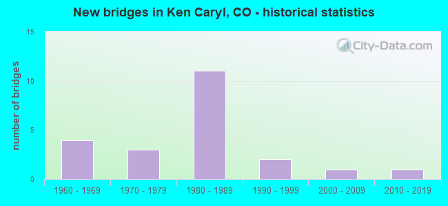
- New bridges - historical statistics
- 41960-1969
- 31970-1979
- 111980-1989
- 21990-1999
- 12000-2009
- 12010-2019
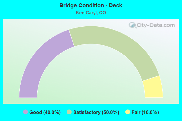
- Bridge Condition - Deck
- 40.0%Good
- 50.0%Satisfactory
- 10.0%Fair
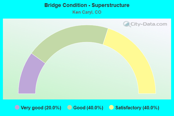
- Bridge Condition - Superstructure
- 20.0%Very good
- 40.0%Good
- 40.0%Satisfactory
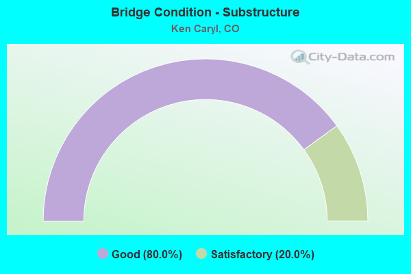
- Bridge Condition - Substructure
- 80.0%Good
- 20.0%Satisfactory
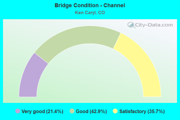
- Bridge Condition - Channel
- 21.4%Very good
- 42.9%Good
- 35.7%Satisfactory
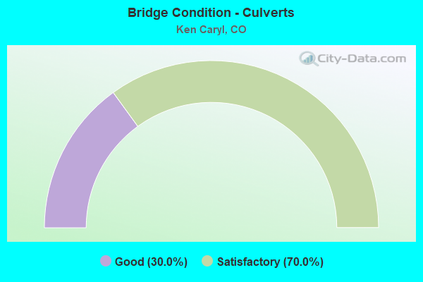
- Bridge Condition - Culverts
- 30.0%Good
- 70.0%Satisfactory
Find on map >> Show street view
Structure Number: F-15-65, Location: 1.4 MI E OF PHILLIPSBURG (Lat: 39.544069, Lng: -105.167689), Route carried "on" structure: County highway , Year Built: 1969, Status: Open, Structure Length: 1.18m (3.87ft), Average Daily Traffic: 2,820 (year 2021), Truck Traffic: 25%, Average Future Daily Traffic: 3,243 (year 2041), Features Intersected: DEER CREEK, Facility Carried by Structure: DEER CRK CANYON RD
Minimum Vertical Clearance: 30.45m (99.90ft), Kilometerpoint: 7.586, Lanes on structure: 2, Owner: County Highway Agency, Approaching Roadway Width: 9.1m (29.9ft), Skew: 4 degrees, Material/Design: Concrete, Design/Construction: Slab, Number Of Spans In Main Unit: 1, Length of Maximum Span: 11.1m (36.4ft), Curb-To-Curb Width: 9.8m (32.2ft), Out-to-Out Width: 11.1m (36.4ft)
Condition: Deck: Good, Superstructure: Good, Substructure: Good, Channel: Satisfactory, Operating Rating: 33.0 metric tons, Method Used To Determine Operating Rating: Load Factor (LF), Inventory Rating: 27.0 metric tons, Method Used To Determine Inventory Rating: Load Factor (LF), Structural Evaluation: Equal to present minimum criteria, Deck Geometry: Meets minimum limits, Waterway Adequacy: Equal to present desirable criteria, Approach Roadway Alignment: Equal to present minimum criteria, Designated Inspection Frequency: Every 24 months, Inspection Date: Febuary 2021, Deck Structure Type: Concrete Cast-file-Place, Wearing Surface/Protective System: Wearing Surface: Bituminous
Find on map >> Show street view
Structure Number: F-16-HZ, Location: 2.0 MI S OF JCT SH 470 (Lat: 39.546261, Lng: -105.088439), Route carried "on" structure: State highway 121B, Year Built: 1968, Status: Open, Structure Length: 0.98m (3.22ft), Average Daily Traffic: 23,000 (year 2020), Truck Traffic: 2%, Average Future Daily Traffic: 27,370 (year 2040), Design Load: HS 20, Features Intersected: DEER CREEK, Facility Carried by Structure: SH 121 ML
Minimum Vertical Clearance: 30+ m (98+ ft), Kilometerpoint: 6.236, Lanes on structure: 4, Base Highway Network: Yes, Owner: State Highway Agency, Approaching Roadway Width: 23.2m (76.1ft), Skew: 10 degrees, Material/Design: Concrete, Design/Construction: Culvert, Number Of Spans In Main Unit: 3, Length of Maximum Span: 3.7m (12.1ft), Out-to-Out Width: 116.8m (383.2ft)
Condition: Channel: Good, Culverts: Satisfactory, Operating Rating: 89.8 metric tons, Method Used To Determine Operating Rating: Field evaluation and documented engineering judgment, Inventory Rating: 89.8 metric tons, Method Used To Determine Inventory Rating: Field evaluation and documented engineering judgment, Structural Evaluation: Equal to present minimum criteria, Waterway Adequacy: Equal to present desirable criteria, Approach Roadway Alignment: Equal to present desirable criteria, Designated Inspection Frequency: Every 24 months, Inspection Date: August 2021
Find on map >> Show street view
Structure Number: F-16-MA, Location: 10.2 MI E - JCT I70 + SH (Lat: 39.578606, Lng: -105.142125), Route carried "on" structure: State highway 470A, Year Built: 1987, Status: Open, Structure Length: 6.04m (19.82ft), Average Daily Traffic: 29,000 (year 2020), Truck Traffic: 3%, Average Future Daily Traffic: 39,150 (year 2040), Features Intersected: KEN CARYL RD, Facility Carried by Structure: SH 470 ML EBND
Minimum Vertical Clearance: 30+ m (98+ ft), Kilometerpoint: 16.489, Lanes on structure: 2, Lanes under structure: 8, Base Highway Network: Yes, Owner: State Highway Agency, Approaching Roadway Width: 11.6m (38.1ft), Skew: 10 degrees, Material/Design: Prestressed concrete continuous, Design/Construction: Stringer/Multi-beam, Number Of Spans In Main Unit: 2, Length of Maximum Span: 29.8m (97.8ft), Curb-To-Curb Width: 11.6m (38.1ft), Out-to-Out Width: 12.6m (41.3ft)
Condition: Deck: Good, Superstructure: Very good, Substructure: Good, Operating Rating: 58.7 metric tons, Method Used To Determine Operating Rating: Load Factor (LF), Inventory Rating: 33.4 metric tons, Method Used To Determine Inventory Rating: Load Factor (LF), Structural Evaluation: Better than present minimum criteria, Deck Geometry: Equal to present minimum criteria, Underclear: Better than present minimum criteria, Approach Roadway Alignment: Equal to present desirable criteria, Designated Inspection Frequency: Every 24 months, Inspection Date: December 2021, Deck Structure Type: Concrete Cast-file-Place, Wearing Surface/Protective System: Wearing Surface: Bituminous, Membrane: Preformed Fabric, Deck Protection: Epoxy Coated Reinforcing
Find on map >> Show street view
Structure Number: F-16-MB, Location: 10.2 MI S. OF I 70 (Lat: 39.578700, Lng: -105.141897), Route carried "on" structure: State highway 470A, Year Built: 1987, Status: Open, Structure Length: 6.04m (19.82ft), Average Daily Traffic: 29,000 (year 2020), Truck Traffic: 3%, Average Future Daily Traffic: 39,150 (year 2040), Design Load: HS 20+Mod, Features Intersected: KEN CARYL RD, Facility Carried by Structure: SH 470 ML WBND
Minimum Vertical Clearance: 30+ m (98+ ft), Kilometerpoint: 16.486, Lanes on structure: 2, Lanes under structure: 8, Base Highway Network: Yes, Owner: State Highway Agency, Approaching Roadway Width: 11.6m (38.1ft), Skew: 10 degrees, Material/Design: Prestressed concrete continuous, Design/Construction: Stringer/Multi-beam, Number Of Spans In Main Unit: 2, Length of Maximum Span: 30.0m (98.4ft), Curb-To-Curb Width: 11.6m (38.1ft), Out-to-Out Width: 12.6m (41.3ft)
Condition: Deck: Good, Superstructure: Good, Substructure: Good, Operating Rating: 58.1 metric tons, Method Used To Determine Operating Rating: Load Factor (LF), Inventory Rating: 32.7 metric tons, Method Used To Determine Inventory Rating: Load Factor (LF), Structural Evaluation: Better than present minimum criteria, Deck Geometry: Equal to present minimum criteria, Underclear: Better than present minimum criteria, Approach Roadway Alignment: Equal to present desirable criteria, Designated Inspection Frequency: Every 48 months, Inspection Date: Febuary 2022, Deck Structure Type: Concrete Cast-file-Place, Wearing Surface/Protective System: Wearing Surface: Bituminous, Membrane: Preformed Fabric, Deck Protection: Epoxy Coated Reinforcing
Find on map >> Show street view
Structure Number: F-16-MC, Location: 12.4 MI S. OF I 70 (Lat: 39.560064, Lng: -105.110358), Route carried "on" structure: State highway 470A, Year Built: 1986, Status: Open, Structure Length: 6.10m (20.01ft), Average Daily Traffic: 24,500 (year 2020), Truck Traffic: 3%, Average Future Daily Traffic: 33,565 (year 2040), Design Load: HS 20+Mod, Features Intersected: KIPLING PARKWAY, Facility Carried by Structure: SH 470 ML EBND
Minimum Vertical Clearance: 30+ m (98+ ft), Kilometerpoint: 20.125, Lanes on structure: 2, Lanes under structure: 7, Base Highway Network: Yes, Owner: State Highway Agency, Approaching Roadway Width: 11.6m (38.1ft), Skew: 10 degrees, Material/Design: Prestressed concrete continuous, Design/Construction: Stringer/Multi-beam, Number Of Spans In Main Unit: 2, Length of Maximum Span: 31.4m (103.0ft), Curb-To-Curb Width: 11.6m (38.1ft), Out-to-Out Width: 12.6m (41.3ft)
Condition: Deck: Satisfactory, Superstructure: Satisfactory, Substructure: Satisfactory, Operating Rating: 59.0 metric tons, Method Used To Determine Operating Rating: Load Factor (LF), Inventory Rating: 35.4 metric tons, Method Used To Determine Inventory Rating: Load Factor (LF), Structural Evaluation: Equal to present minimum criteria, Deck Geometry: Equal to present minimum criteria, Underclear: Better than present minimum criteria, Approach Roadway Alignment: Equal to present desirable criteria, Designated Inspection Frequency: Every 24 months, Inspection Date: November 2021, Deck Structure Type: Concrete Cast-file-Place, Wearing Surface/Protective System: Wearing Surface: Bituminous, Membrane: Preformed Fabric, Deck Protection: Epoxy Coated Reinforcing
Find on map >> Show street view
Structure Number: F-16-MD, Location: 12.4 MI S OF I 70 (Lat: 39.560272, Lng: -105.110344), Route carried "on" structure: State highway 470A, Year Built: 1986, Status: Open, Structure Length: 6.10m (20.01ft), Average Daily Traffic: 24,500 (year 2020), Truck Traffic: 3%, Average Future Daily Traffic: 33,565 (year 2040), Design Load: HS 20+Mod, Features Intersected: KIPLING PARKWAY, Facility Carried by Structure: SH 470 ML WBND
Minimum Vertical Clearance: 30+ m (98+ ft), Kilometerpoint: 20.125, Lanes on structure: 2, Lanes under structure: 7, Base Highway Network: Yes, Owner: State Highway Agency, Approaching Roadway Width: 11.6m (38.1ft), Skew: 10 degrees, Material/Design: Prestressed concrete continuous, Design/Construction: Stringer/Multi-beam, Number Of Spans In Main Unit: 2, Length of Maximum Span: 31.3m (102.7ft), Curb-To-Curb Width: 11.6m (38.1ft), Out-to-Out Width: 12.6m (41.3ft)
Condition: Deck: Satisfactory, Superstructure: Very good, Substructure: Good, Operating Rating: 64.4 metric tons, Method Used To Determine Operating Rating: Load Factor (LF), Inventory Rating: 31.8 metric tons, Method Used To Determine Inventory Rating: Load Factor (LF), Structural Evaluation: Better than present minimum criteria, Deck Geometry: Equal to present minimum criteria, Underclear: Better than present minimum criteria, Approach Roadway Alignment: Equal to present desirable criteria, Designated Inspection Frequency: Every 24 months, Inspection Date: December 2021, Deck Structure Type: Concrete Cast-file-Place, Wearing Surface/Protective System: Wearing Surface: Bituminous, Membrane: Preformed Fabric, Deck Protection: Epoxy Coated Reinforcing
Find on map >> Show street view
Structure Number: F-16-MG, Location: 13.9 MI E - JCT SH 470 + (Lat: 39.553739, Lng: -105.085497), Route carried "on" structure: State highway 470A, Year Built: 1987, Status: Open, Structure Length: 9.24m (30.31ft), Average Daily Traffic: 30,500 (year 2020), Truck Traffic: 3%, Average Future Daily Traffic: 41,480 (year 2040), Design Load: HS 20, Features Intersected: SH 121-WADSWORTH BLVD, Facility Carried by Structure: SH 470 ML EBND
Minimum Vertical Clearance: 30+ m (98+ ft), Kilometerpoint: 22.437, Lanes on structure: 2, Lanes under structure: 8, Base Highway Network: Yes, Owner: State Highway Agency, Approaching Roadway Width: 11.6m (38.1ft), Skew: 14 degrees, Material/Design: Prestressed concrete continuous, Design/Construction: Box Beam or Girders - Multiple, Number Of Spans In Main Unit: 2, Length of Maximum Span: 45.7m (149.9ft), Curb-To-Curb Width: 11.6m (38.1ft), Out-to-Out Width: 12.6m (41.3ft)
Condition: Deck: Satisfactory, Superstructure: Satisfactory, Substructure: Good, Operating Rating: 99.2 metric tons, Method Used To Determine Operating Rating: Load Factor (LF), Inventory Rating: 59.3 metric tons, Method Used To Determine Inventory Rating: Load Factor (LF), Structural Evaluation: Equal to present minimum criteria, Deck Geometry: Equal to present minimum criteria, Underclear: Somewhat better than minimum adequacy, Approach Roadway Alignment: Equal to present desirable criteria, Designated Inspection Frequency: Every 24 months, Inspection Date: December 2021, Deck Structure Type: Other, Wearing Surface/Protective System: Wearing Surface: Bituminous, Membrane: Preformed Fabric, Deck Protection: Epoxy Coated Reinforcing
Find on map >> Show street view
Structure Number: F-16-MH, Location: 3.2 MI W - JCT US 85 + SH (Lat: 39.553972, Lng: -105.085397), Route carried "on" structure: State highway 470A, Year Built: 1987, Status: Open, Structure Length: 8.64m (28.35ft), Average Daily Traffic: 30,500 (year 2020), Truck Traffic: 3%, Average Future Daily Traffic: 41,480 (year 2040), Design Load: HS 20+Mod, Features Intersected: SH 121-WADSWORTH BLVD, Facility Carried by Structure: SH 470 ML WBND
Minimum Vertical Clearance: 30+ m (98+ ft), Kilometerpoint: 22.447, Lanes on structure: 2, Lanes under structure: 8, Base Highway Network: Yes, Owner: State Highway Agency, Approaching Roadway Width: 11.6m (38.1ft), Skew: 14 degrees, Material/Design: Prestressed concrete continuous, Design/Construction: Box Beam or Girders - Multiple, Number Of Spans In Main Unit: 2, Length of Maximum Span: 43.0m (141.1ft), Curb-To-Curb Width: 11.6m (38.1ft), Out-to-Out Width: 12.6m (41.3ft)
Condition: Deck: Satisfactory, Superstructure: Good, Substructure: Satisfactory, Inventory Rating: 60.8 metric tons, Method Used To Determine Inventory Rating: Load Factor (LF), Structural Evaluation: Equal to present minimum criteria, Deck Geometry: Equal to present minimum criteria, Underclear: Somewhat better than minimum adequacy, Approach Roadway Alignment: Equal to present desirable criteria, Designated Inspection Frequency: Every 24 months, Inspection Date: December 2021, Deck Structure Type: Concrete Cast-file-Place, Wearing Surface/Protective System: Wearing Surface: Bituminous, Membrane: Preformed Fabric, Deck Protection: Epoxy Coated Reinforcing
Find on map >> Show street view
Structure Number: F-16-ST, Location: .1 MI N.OF JCT470&KIPLING (Lat: 39.561042, Lng: -105.109744), Route carried "on" structure: ServiceState highway 470A, Year Built: 1987, Status: Open, Structure Length: 0.67m (2.20ft), Average Daily Traffic: 49,000 (year 2020), Truck Traffic: 3%, Average Future Daily Traffic: 67,130 (year 2040), Design Load: HS 20, Features Intersected: MASSEY DRAW AR, Facility Carried by Structure: KIPLING PARKWAY AR
Minimum Vertical Clearance: 30+ m (98+ ft), Kilometerpoint: 0.074, Lanes on structure: 7, Base Highway Network: Yes, Owner: State Highway Agency, Approaching Roadway Width: 23.2m (76.1ft), Skew: 1 degrees, Material/Design: Concrete, Design/Construction: Culvert, Number Of Spans In Main Unit: 2, Length of Maximum Span: 3.2m (10.5ft), Out-to-Out Width: 62.3m (204.4ft)
Condition: Channel: Satisfactory, Culverts: Satisfactory, Operating Rating: 36.3 metric tons, Method Used To Determine Operating Rating: Field evaluation and documented engineering judgment, Inventory Rating: 32.7 metric tons, Method Used To Determine Inventory Rating: Field evaluation and documented engineering judgment, Structural Evaluation: Equal to present minimum criteria, Waterway Adequacy: Equal to present desirable criteria, Approach Roadway Alignment: Equal to present desirable criteria, Designated Inspection Frequency: Every 24 months, Inspection Date: December 2021
Find on map >> Show street view
Structure Number: G-15-11, Location: 3.6 MI W OF SH75 (Lat: 39.547486, Lng: -105.153267), Route carried "on" structure: County highway , Year Built: 1978, Status: Open, Structure Length: 1.28m (4.20ft), Average Daily Traffic: 554 (year 2021), Average Future Daily Traffic: 637 (year 2041), Features Intersected: DEER CREEK, Facility Carried by Structure: GRIZZLY DRIVE
Minimum Vertical Clearance: 30+ m (98+ ft), Kilometerpoint: 0.024, Lanes on structure: 2, Owner: County Highway Agency, Approaching Roadway Width: 8.5m (27.9ft), Material/Design: Prestressed concrete, Design/Construction: Tee Beam, Number Of Spans In Main Unit: 1, Length of Maximum Span: 12.2m (40.0ft), Curb-To-Curb Width: 9.1m (29.9ft), Out-to-Out Width: 9.8m (32.2ft)
Condition: Deck: Fair, Superstructure: Satisfactory, Substructure: Good, Channel: Good, Operating Rating: 62.7 metric tons, Method Used To Determine Operating Rating: Load Factor (LF), Inventory Rating: 37.0 metric tons, Method Used To Determine Inventory Rating: Load Factor (LF), Structural Evaluation: Equal to present minimum criteria, Deck Geometry: Equal to present minimum criteria, Waterway Adequacy: Equal to present desirable criteria, Approach Roadway Alignment: Equal to present desirable criteria, Designated Inspection Frequency: Every 24 months, Inspection Date: Febuary 2021, Deck Structure Type: Other, Wearing Surface/Protective System: Wearing Surface: Bituminous
Find on map >> Show street view
Structure Number: G-15-63, Location: 2.7 MI W OF SH75 (Lat: 39.549222, Lng: -105.134700), Route carried "on" structure: County highway , Year Built: 1969, Status: Open, Structure Length: 1.31m (4.30ft), Average Daily Traffic: 889 (year 2021), Truck Traffic: 4%, Average Future Daily Traffic: 1,022 (year 2041), Features Intersected: DEER CREEK, Facility Carried by Structure: COUGAR ROAD
Minimum Vertical Clearance: 30+ m (98+ ft), Kilometerpoint: 1.263, Lanes on structure: 2, Owner: County Highway Agency, Approaching Roadway Width: 6.1m (20.0ft), Material/Design: Concrete continuous, Design/Construction: Slab, Number Of Spans In Main Unit: 2, Length of Maximum Span: 6.0m (19.7ft), Curb-To-Curb Width: 7.2m (23.6ft), Out-to-Out Width: 8.5m (27.9ft)
Condition: Deck: Good, Superstructure: Good, Substructure: Good, Channel: Satisfactory, Operating Rating: 29.9 metric tons, Method Used To Determine Operating Rating: Field evaluation and documented engineering judgment, Inventory Rating: 18.1 metric tons, Method Used To Determine Inventory Rating: Field evaluation and documented engineering judgment, Structural Evaluation: Somewhat better than minimum adequacy, Deck Geometry: Meets minimum limits, Waterway Adequacy: Better than present minimum criteria, Approach Roadway Alignment: Equal to present desirable criteria, Designated Inspection Frequency: Every 24 months, Inspection Date: Febuary 2021, Deck Structure Type: Concrete Cast-file-Place, Wearing Surface/Protective System: Wearing Surface: Bituminous, Membrane: Built-up
Find on map >> Show street view
Structure Number: G-15-64, Location: 2.5 MI E OF PHILLIPSBURG (Lat: 39.543161, Lng: -105.162397), Route carried "on" structure: County highway , Year Built: 1969, Status: Open, Structure Length: 1.25m (4.10ft), Average Daily Traffic: 2,056 (year 2021), Truck Traffic: 25%, Average Future Daily Traffic: 2,364 (year 2041), Features Intersected: DEER CREEK, Facility Carried by Structure: DEER CRK CANYON RD
Minimum Vertical Clearance: 30+ m (98+ ft), Kilometerpoint: 8.090, Lanes on structure: 2, Owner: County Highway Agency, Approaching Roadway Width: 9.1m (29.9ft), Skew: 4 degrees, Material/Design: Concrete, Design/Construction: Slab, Number Of Spans In Main Unit: 1, Length of Maximum Span: 11.7m (38.4ft), Curb-To-Curb Width: 10.0m (32.8ft), Out-to-Out Width: 11.2m (36.7ft)
Condition: Deck: Satisfactory, Superstructure: Satisfactory, Substructure: Good, Channel: Good, Operating Rating: 41.6 metric tons, Method Used To Determine Operating Rating: Load Factor (LF), Inventory Rating: 35.1 metric tons, Method Used To Determine Inventory Rating: Load Factor (LF), Structural Evaluation: Equal to present minimum criteria, Deck Geometry: Meets minimum limits, Waterway Adequacy: Equal to present desirable criteria, Approach Roadway Alignment: Equal to present minimum criteria, Designated Inspection Frequency: Every 24 months, Inspection Date: March 2021, Deck Structure Type: Concrete Cast-file-Place, Wearing Surface/Protective System: Wearing Surface: Bituminous
Find on map >> Show street view
Structure Number: G-15-98, Location: 3.2 MI W OF SH 75 (Lat: 39.551328, Lng: -105.140611), Route carried "on" structure: County highway , Year Built: 1975, Status: Open, Structure Length: 1.10m (3.61ft), Average Daily Traffic: 3,081 (year 2021), Truck Traffic: 9%, Average Future Daily Traffic: 3,543 (year 2041), Features Intersected: DOCKMAN GULCH, Facility Carried by Structure: DEER CRK CANYON RD
Minimum Vertical Clearance: 30+ m (98+ ft), Kilometerpoint: 10.309, Lanes on structure: 3, Owner: County Highway Agency, Approaching Roadway Width: 9.1m (29.9ft), Skew: 3 degrees, Material/Design: Concrete, Design/Construction: Culvert, Number Of Spans In Main Unit: 2, Length of Maximum Span: 5.0m (16.4ft), Out-to-Out Width: 24.3m (79.7ft)
Condition: Channel: Satisfactory, Culverts: Satisfactory, Operating Rating: 36.3 metric tons, Method Used To Determine Operating Rating: Field evaluation and documented engineering judgment, Inventory Rating: 32.7 metric tons, Method Used To Determine Inventory Rating: Field evaluation and documented engineering judgment, Structural Evaluation: Equal to present minimum criteria, Waterway Adequacy: Equal to present desirable criteria, Approach Roadway Alignment: Equal to present desirable criteria, Designated Inspection Frequency: Every 48 months, Inspection Date: Febuary 2019
Find on map >> Show street view
Structure Number: G-16-119, Location: 1.5 MI S OF KEY CARYL AVE (Lat: 39.557417, Lng: -105.150281), Route carried "on" structure: County highway , Year Built: 1975, Status: Open, Structure Length: 0.66m (2.17ft), Average Daily Traffic: 1,801 (year 2021), Truck Traffic: 4%, Average Future Daily Traffic: 2,071 (year 2041), Features Intersected: DEER CREEK TRIBUTARY, Facility Carried by Structure: SOUTH VALLEY ROAD
Minimum Vertical Clearance: 30+ m (98+ ft), Kilometerpoint: 1.024, Lanes on structure: 2, Owner: County Highway Agency, Approaching Roadway Width: 8.4m (27.6ft), Skew: 3 degrees, Material/Design: Concrete, Design/Construction: Culvert, Number Of Spans In Main Unit: 2, Length of Maximum Span: 3.1m (10.2ft), Out-to-Out Width: 21.1m (69.2ft)
Condition: Channel: Very good, Culverts: Good, Operating Rating: 36.3 metric tons, Method Used To Determine Operating Rating: Field evaluation and documented engineering judgment, Inventory Rating: 32.7 metric tons, Method Used To Determine Inventory Rating: Field evaluation and documented engineering judgment, Structural Evaluation: Better than present minimum criteria, Waterway Adequacy: Equal to present desirable criteria, Approach Roadway Alignment: Equal to present desirable criteria, Designated Inspection Frequency: Every 24 months, Inspection Date: March 2021
Find on map >> Show street view
Structure Number: H-15-1, Location: JUST NORTH OF UTE AVENUE (Lat: 39.558469, Lng: -105.092278), Route carried "on" structure: County highway , Year Built: 2000, Status: Open, Structure Length: 0.63m (2.07ft), Average Daily Traffic: 1,062 (year 2021), Truck Traffic: 1%, Average Future Daily Traffic: 1,221 (year 2041), Features Intersected: MASSEY DRAW, Facility Carried by Structure: CARR STREET
Minimum Vertical Clearance: 30.45m (99.90ft), Kilometerpoint: 0.553, Lanes on structure: 2, Owner: County Highway Agency, Approaching Roadway Width: 12.2m (40.0ft), Material/Design: Concrete, Design/Construction: Culvert, Number Of Spans In Main Unit: 2, Length of Maximum Span: 3.0m (9.8ft), Curb or Sidewalk Widths: Left: 1.4m (4.6ft), Right: 0.0m, Out-to-Out Width: 66.6m (218.5ft)
Condition: Channel: Good, Culverts: Satisfactory, Operating Rating: 36.3 metric tons, Method Used To Determine Operating Rating: Field evaluation and documented engineering judgment, Inventory Rating: 32.7 metric tons, Method Used To Determine Inventory Rating: Field evaluation and documented engineering judgment, Structural Evaluation: Equal to present minimum criteria, Waterway Adequacy: Equal to present desirable criteria, Approach Roadway Alignment: Equal to present desirable criteria, Designated Inspection Frequency: Every 24 months, Inspection Date: Febuary 2021
Find on map >> Show street view
Structure Number: H-15-105, Location: .1 MI SO OF CHATFIELD (Lat: 39.564283, Lng: -105.092231), Route carried "on" structure: County highway , Year Built: 1985, Status: Open, Structure Length: 1.53m (5.02ft), Average Daily Traffic: 1,189 (year 2021), Truck Traffic: 2%, Average Future Daily Traffic: 1,367 (year 2041), Features Intersected: LOCAL DRAINAGE, Facility Carried by Structure: CARR STREET
Minimum Vertical Clearance: 30.45m (99.90ft), Kilometerpoint: 1.181, Lanes on structure: 2, Owner: County Highway Agency, Approaching Roadway Width: 8.5m (27.9ft), Skew: 3 degrees, Material/Design: Concrete, Design/Construction: Culvert, Number Of Spans In Main Unit: 5, Length of Maximum Span: 2.8m (9.2ft), Curb-To-Curb Width: 9.3m (30.5ft), Out-to-Out Width: 12.3m (40.4ft)
Condition: Channel: Satisfactory, Culverts: Good, Operating Rating: 36.3 metric tons, Method Used To Determine Operating Rating: Field evaluation and documented engineering judgment, Inventory Rating: 32.7 metric tons, Method Used To Determine Inventory Rating: Field evaluation and documented engineering judgment, Structural Evaluation: Better than present minimum criteria, Deck Geometry: Somewhat better than minimum adequacy, Waterway Adequacy: Equal to present desirable criteria, Approach Roadway Alignment: Equal to present desirable criteria, Designated Inspection Frequency: Every 24 months, Inspection Date: Febuary 2021
Find on map >> Show street view
Structure Number: H-15-107, Location: 0.5 mi W. of Wadsworth (Lat: 39.566208, Lng: -105.095356), Route carried "on" structure: County highway , Year Built: 2010, Status: Open, Structure Length: 0.63m (2.07ft), Average Daily Traffic: 9,714 (year 2021), Truck Traffic: 1%, Average Future Daily Traffic: 11,172 (year 2041), Features Intersected: WILLOW CREEK, Facility Carried by Structure: W. CHATFIELD AVE
Minimum Vertical Clearance: 30.45m (99.90ft), Kilometerpoint: 0.002, Lanes on structure: 5, Owner: County Highway Agency, Approaching Roadway Width: 21.2m (69.6ft), Skew: 1 degrees, Material/Design: Concrete, Design/Construction: Culvert, Number Of Spans In Main Unit: 1, Length of Maximum Span: 6.3m (20.7ft), Curb or Sidewalk Widths: Left: 1.7m (5.6ft), Right: 2.3m (7.5ft), Out-to-Out Width: 30.8m (101.0ft)
Condition: Channel: Very good, Culverts: Good, Operating Rating: 36.3 metric tons, Method Used To Determine Operating Rating: Field evaluation and documented engineering judgment, Inventory Rating: 32.7 metric tons, Method Used To Determine Inventory Rating: Field evaluation and documented engineering judgment, Structural Evaluation: Better than present minimum criteria, Waterway Adequacy: Equal to present desirable criteria, Approach Roadway Alignment: Equal to present desirable criteria, Designated Inspection Frequency: Every 24 months, Inspection Date: March 2021
Find on map >> Show street view
Structure Number: H-16-102, Location: .1 MI E OF GARRISON (Lat: 39.580778, Lng: -105.097944), Route carried "on" structure: County highway , Year Built: 1996, Status: Open, Structure Length: 1.22m (4.00ft), Average Daily Traffic: 12,694 (year 2021), Truck Traffic: 4%, Average Future Daily Traffic: 14,598 (year 2041), Design Load: HS 20, Features Intersected: MASSEY DRAW, Facility Carried by Structure: KEN CARYL AVE
Minimum Vertical Clearance: 30.45m (99.90ft), Kilometerpoint: 6.011, Lanes on structure: 6, Owner: County Highway Agency, Approaching Roadway Width: 18.3m (60.0ft), Skew: 24 degrees, Material/Design: Concrete, Design/Construction: Culvert, Number Of Spans In Main Unit: 3, Length of Maximum Span: 3.9m (12.8ft), Curb or Sidewalk Widths: Left: 2.6m (8.5ft), Right: 2.6m (8.5ft), Out-to-Out Width: 37.2m (122.0ft)
Condition: Channel: Good, Culverts: Satisfactory, Operating Rating: 38.5 metric tons, Method Used To Determine Operating Rating: Load Factor (LF), Inventory Rating: 23.0 metric tons, Method Used To Determine Inventory Rating: Load Factor (LF), Structural Evaluation: Somewhat better than minimum adequacy, Waterway Adequacy: Equal to present desirable criteria, Approach Roadway Alignment: Equal to present desirable criteria, Designated Inspection Frequency: Every 24 months, Inspection Date: Febuary 2021
Find on map >> Show street view
Structure Number: H-16-103, Location: JUST S OF KEN CARYL (Lat: 39.580453, Lng: -105.097064), Route carried "on" structure: County highway , Year Built: 1996, Status: Open, Structure Length: 0.85m (2.79ft), Average Daily Traffic: 142 (year 2021), Truck Traffic: 2%, Average Future Daily Traffic: 164 (year 2041), Design Load: HS 20, Features Intersected: MASSEY DRAW, Facility Carried by Structure: ESTES COURT
Minimum Vertical Clearance: 30.45m (99.90ft), Kilometerpoint: 0.308, Lanes on structure: 2, Owner: County Highway Agency, Approaching Roadway Width: 7.3m (24.0ft), Material/Design: Concrete, Design/Construction: Culvert, Number Of Spans In Main Unit: 3, Length of Maximum Span: 2.7m (8.9ft), Out-to-Out Width: 23.0m (75.5ft)
Condition: Channel: Very good, Culverts: Satisfactory, Operating Rating: 43.8 metric tons, Method Used To Determine Operating Rating: Load Factor (LF), Inventory Rating: 26.2 metric tons, Method Used To Determine Inventory Rating: Load Factor (LF), Structural Evaluation: Equal to present minimum criteria, Waterway Adequacy: Equal to present desirable criteria, Approach Roadway Alignment: Equal to present desirable criteria, Designated Inspection Frequency: Every 24 months, Inspection Date: Febuary 2021
Find on map >> Show street view
Structure Number: H-16-105, Location: .2 MI S OF KEN CARYL ROAD (Lat: 39.578928, Lng: -105.091436), Route carried "on" structure: County highway , Year Built: 1980, Status: Open, Structure Length: 0.64m (2.10ft), Average Daily Traffic: 2,990 (year 2021), Truck Traffic: 2%, Average Future Daily Traffic: 3,439 (year 2041), Features Intersected: MASSEY DRAW, Facility Carried by Structure: CARR STREET
Minimum Vertical Clearance: 30.45m (99.90ft), Kilometerpoint: 1.415, Lanes on structure: 2, Owner: County Highway Agency, Approaching Roadway Width: 12.2m (40.0ft), Material/Design: Concrete, Design/Construction: Culvert, Number Of Spans In Main Unit: 2, Length of Maximum Span: 3.0m (9.8ft), Curb or Sidewalk Widths: Left: 0.0m, Right: 1.2m (3.9ft), Curb-To-Curb Width: 12.2m (40.0ft), Out-to-Out Width: 20.7m (67.9ft)
Condition: Channel: Good, Culverts: Satisfactory, Operating Rating: 36.3 metric tons, Method Used To Determine Operating Rating: Field evaluation and documented engineering judgment, Inventory Rating: 32.7 metric tons, Method Used To Determine Inventory Rating: Field evaluation and documented engineering judgment, Structural Evaluation: Equal to present minimum criteria, Deck Geometry: Equal to present minimum criteria, Waterway Adequacy: Better than present minimum criteria, Approach Roadway Alignment: Equal to present desirable criteria, Designated Inspection Frequency: Every 24 months, Inspection Date: Febuary 2021
Find on map >> Show street view
Structure Number: F-16-MG, Location: 13.9 MI E - JCT SH 470 + (Lat: 39.553739, Lng: -105.085497), Route carried "under" structure: State highway 121A, Year Built: 1987, Structure Length: 0. m, Average Daily Traffic: 24,000 (year 2011), Truck Traffic: 3%, Features Intersected: SH 121-WADSWORTH BLVD, Facility Carried by Structure: SH 470 ML EBND
Minimum Vertical Clearance: 6.94m (22.77ft), Kilometerpoint: 0.016, Lanes on structure: 2, Lanes under structure: 8, Material/Design: Prestressed concrete continuous, Design/Construction: Box Beam or Girders - Multiple, Length of Maximum Span: 45.7m (149.9ft)
Find on map >> Show street view
Structure Number: F-16-MH, Location: 3.2 MI W - JCT US 85 + SH (Lat: 39.553972, Lng: -105.085397), Route carried "under" structure: State highway 121A, Year Built: 1987, Structure Length: 0. m, Average Daily Traffic: 24,000 (year 2011), Truck Traffic: 3%, Features Intersected: SH 121-WADSWORTH BLVD, Facility Carried by Structure: SH 470 ML WBND
Minimum Vertical Clearance: 5.49m (18.01ft), Kilometerpoint: 0.032, Lanes on structure: 2, Lanes under structure: 8, Material/Design: Prestressed concrete continuous, Design/Construction: Box Beam or Girders - Multiple, Length of Maximum Span: 43.0m (141.1ft)