Bridge Statistics for Kersey, Colorado (CO)
Condition, Traffic, Stress, Structural Evaluation, Project Costs
- National Bridge Inventory (NBI) Statistics
- 25Number of bridges
- 243ft / 74.1mTotal length
- $3,575,000Total costs
- 71,083Total average daily traffic
- 20,824Total average daily truck traffic
- 103,553Total future (year 2032) average daily traffic
- National Bridge Inventory (NBI) Registered Bridges for Kersey
- No street view available for this location
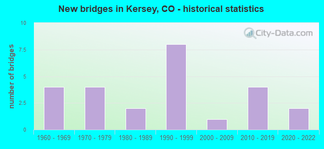
- New bridges - historical statistics
- 41960-1969
- 41970-1979
- 21980-1989
- 81990-1999
- 12000-2009
- 42010-2019
- 22020-2022
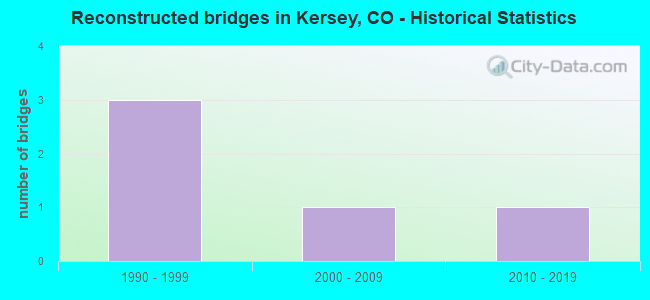
- Reconstructed bridges - Historical Statistics
- 31990-1999
- 12000-2009
- 12010-2019
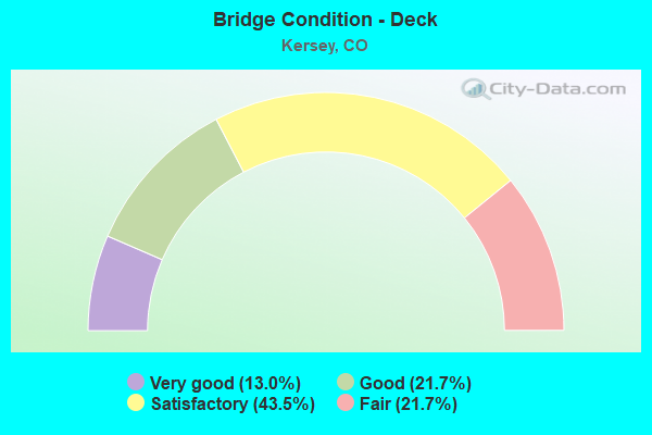
- Bridge Condition - Deck
- 13.0%Very good
- 21.7%Good
- 43.5%Satisfactory
- 21.7%Fair
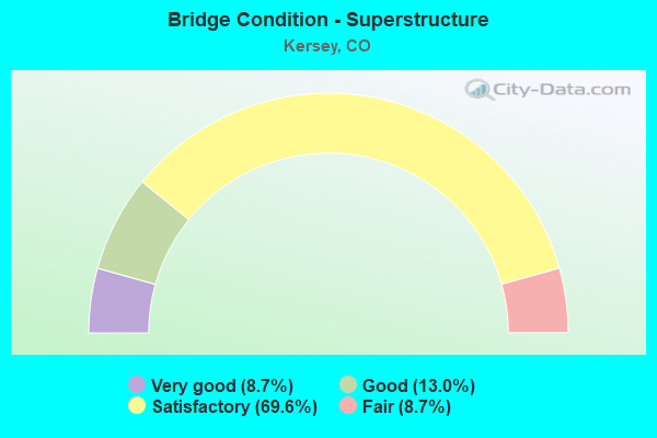
- Bridge Condition - Superstructure
- 8.7%Very good
- 13.0%Good
- 69.6%Satisfactory
- 8.7%Fair
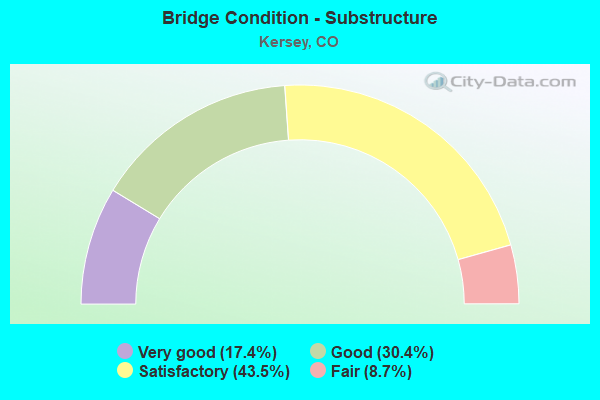
- Bridge Condition - Substructure
- 17.4%Very good
- 30.4%Good
- 43.5%Satisfactory
- 8.7%Fair
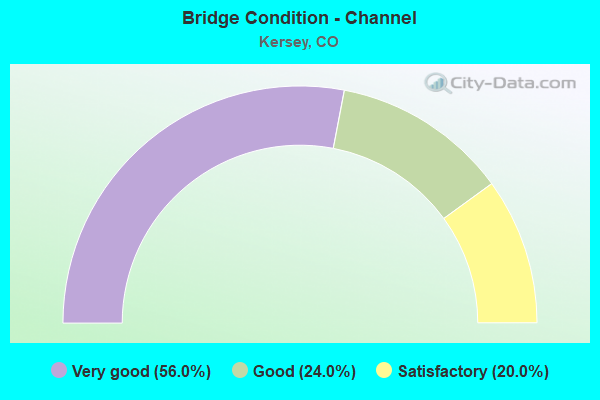
- Bridge Condition - Channel
- 56.0%Very good
- 24.0%Good
- 20.0%Satisfactory
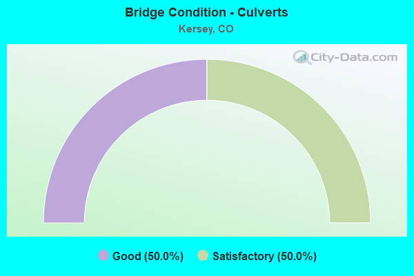
- Bridge Condition - Culverts
- 50.0%Good
- 50.0%Satisfactory
Find on map >> Show street view
Structure Number: C-18-FE, Location: _ (Lat: 40.392756, Lng: -104.635025), Route carried "on" structure: US 34A, Year Built: 2015, Status: Open, Structure Length: 8.05m (26.41ft), Average Daily Traffic: 18,000 (year 2020), Truck Traffic: 10%, Average Future Daily Traffic: 27,540 (year 2040), Design Load: HL 93, Features Intersected: FLOODPLAIN, Facility Carried by Structure: US 34 ML
Minimum Vertical Clearance: 0.00m, Kilometerpoint: 185.099, Lanes on structure: 6, Owner: State Highway Agency, Approaching Roadway Width: 28.0m (91.9ft), Skew: 3 degrees, Material/Design: Prestressed concrete continuous, Design/Construction: Stringer/Multi-beam, Number Of Spans In Main Unit: 3, Length of Maximum Span: 26.7m (87.6ft), Curb-To-Curb Width: 28.0m (91.9ft), Out-to-Out Width: 29.0m (95.1ft)
Condition: Deck: Very good, Superstructure: Very good, Substructure: Very good, Channel: Very good, Operating Rating: 45.4 metric tons, Method Used To Determine Operating Rating: Load and Resistance Factor Rating (LRFR) rating reported by rating factor(RF) method using HL-93 loadings, Inventory Rating: 32.4 metric tons, Method Used To Determine Inventory Rating: Load and Resistance Factor Rating (LRFR) rating reported by rating factor(RF) method using HL-93 loadings, Structural Evaluation: Equal to present desirable criteria, Deck Geometry: High priority of corrective action, Waterway Adequacy: Equal to present desirable criteria, Approach Roadway Alignment: Equal to present desirable criteria, Designated Inspection Frequency: Every 24 months, Inspection Date: August 2021, Deck Structure Type: Concrete Precast Panels, Wearing Surface/Protective System: Wearing Surface: Bituminous, Membrane: Built-up, Deck Protection: Epoxy Coated Reinforcing
Find on map >> Show street view
Structure Number: C-19-AJ, Location: 9 MI E OF JCT 34D[GREELEY (Lat: 40.359672, Lng: -104.484272), Route carried "on" structure: US 34A, Year Built: 1999, Status: Open, Structure Length: 0.76m (2.49ft), Average Daily Traffic: 7,000 (year 2020), Truck Traffic: 14%, Average Future Daily Traffic: 9,520 (year 2040), Design Load: HS 20+Mod, Features Intersected: BOX ELDER CREEK, Facility Carried by Structure: US 34 ML
Minimum Vertical Clearance: 30+ m (98+ ft), Kilometerpoint: 199.057, Lanes on structure: 4, Base Highway Network: Yes, Owner: State Highway Agency, Approaching Roadway Width: 23.2m (76.1ft), Skew: 1 degrees, Material/Design: Concrete, Design/Construction: Culvert, Number Of Spans In Main Unit: 2, Length of Maximum Span: 3.7m (12.1ft), Out-to-Out Width: 47.1m (154.5ft)
Condition: Channel: Satisfactory, Culverts: Satisfactory, Operating Rating: 36.3 metric tons, Method Used To Determine Operating Rating: Field evaluation and documented engineering judgment, Inventory Rating: 32.7 metric tons, Method Used To Determine Inventory Rating: Field evaluation and documented engineering judgment, Structural Evaluation: Equal to present minimum criteria, Waterway Adequacy: Better than present minimum criteria, Approach Roadway Alignment: Equal to present desirable criteria, Designated Inspection Frequency: Every 24 months, Inspection Date: November 2021
Find on map >> Show street view
Structure Number: WEL045.5-054.5A, Location: 0.2 Mi N of Co Rd 54.5 (Lat: 40.388500, Lng: -104.630528), Route carried "on" structure: County highway , Year Built: 1970, Status: Open, Structure Length: 1.06m (3.48ft), Average Daily Traffic: 30 (year 2021), Truck Traffic: 5%, Average Future Daily Traffic: 43 (year 2041), Design Load: HS 20, Features Intersected: Latham Ditch, Facility Carried by Structure: County Road 45.5
Minimum Vertical Clearance: 30+ m (98+ ft), Kilometerpoint: 0.404, Lanes on structure: 2, Owner: County Highway Agency, Approaching Roadway Width: 9.3m (30.5ft), Material/Design: Steel, Design/Construction: Stringer/Multi-beam, Number Of Spans In Main Unit: 1, Length of Maximum Span: 9.8m (32.2ft), Curb-To-Curb Width: 9.3m (30.5ft), Out-to-Out Width: 9.8m (32.2ft)
Condition: Deck: Fair, Superstructure: Satisfactory, Substructure: Good, Channel: Very good, Operating Rating: 33.4 metric tons, Method Used To Determine Operating Rating: Load Factor (LF), Inventory Rating: 20.0 metric tons, Method Used To Determine Inventory Rating: Load Factor (LF), Structural Evaluation: Somewhat better than minimum adequacy, Deck Geometry: Better than present minimum criteria, Waterway Adequacy: Equal to present desirable criteria, Approach Roadway Alignment: Equal to present desirable criteria, Designated Inspection Frequency: Every 24 months, Inspection Date: April 2020, Deck Structure Type: Corrugated Steel, Wearing Surface/Protective System: Wearing Surface: Gravel
Find on map >> Show street view
Structure Number: WEL047.0-054.0A, Location: 0.9 Mi N of Co Rd 54 (Lat: 40.389250, Lng: -104.621056), Route carried "on" structure: County highway , Year Built: 1991, Status: Open, Structure Length: 1.07m (3.51ft), Average Daily Traffic: 969 (year 2021), Truck Traffic: 34%, Average Future Daily Traffic: 1,376 (year 2041), Design Load: HS 20, Features Intersected: Latham Ditch, Facility Carried by Structure: County Road 47
Minimum Vertical Clearance: 30+ m (98+ ft), Kilometerpoint: 18.916, Lanes on structure: 2, Owner: County Highway Agency, Approaching Roadway Width: 7.3m (24.0ft), Skew: 3 degrees, Material/Design: Concrete, Design/Construction: Slab, Number Of Spans In Main Unit: 1, Length of Maximum Span: 9.8m (32.2ft), Curb-To-Curb Width: 9.5m (31.2ft), Out-to-Out Width: 9.8m (32.2ft)
Condition: Deck: Satisfactory, Superstructure: Satisfactory, Substructure: Good, Channel: Good, Operating Rating: 36.3 metric tons, Method Used To Determine Operating Rating: Field evaluation and documented engineering judgment, Inventory Rating: 32.7 metric tons, Method Used To Determine Inventory Rating: Field evaluation and documented engineering judgment, Structural Evaluation: Equal to present minimum criteria, Deck Geometry: Equal to present minimum criteria, Waterway Adequacy: Equal to present desirable criteria, Approach Roadway Alignment: Equal to present desirable criteria, Designated Inspection Frequency: Every 24 months, Inspection Date: April 2020, Deck Structure Type: Concrete Cast-file-Place, Wearing Surface/Protective System: Wearing Surface: Bituminous, Membrane: Preformed Fabric, Deck Protection: Epoxy Coated Reinforcing
Find on map >> Show street view
Structure Number: WEL048.0_047.0A, Location: 0.5 Mi E of Co Rd 47 (Lat: 40.334083, Lng: -104.612556), Route carried "on" structure: County highway , Year Built: 1998, Status: Open, Structure Length: 1.49m (4.89ft), Average Daily Traffic: 173 (year 2021), Truck Traffic: 45%, Average Future Daily Traffic: 246 (year 2041), Design Load: HS 20, Features Intersected: Gilmore Ditch, Facility Carried by Structure: County Road 48
Minimum Vertical Clearance: 30+ m (98+ ft), Kilometerpoint: 3.909, Lanes on structure: 2, Owner: County Highway Agency, Approaching Roadway Width: 6.1m (20.0ft), Skew: 3 degrees, Material/Design: Steel, Design/Construction: Stringer/Multi-beam, Number Of Spans In Main Unit: 1, Length of Maximum Span: 14.4m (47.2ft), Curb-To-Curb Width: 9.4m (30.8ft), Out-to-Out Width: 9.7m (31.8ft)
Condition: Deck: Fair, Superstructure: Satisfactory, Substructure: Good, Channel: Very good, Operating Rating: 54.2 metric tons, Method Used To Determine Operating Rating: Load Factor (LF), Inventory Rating: 32.5 metric tons, Method Used To Determine Inventory Rating: Load Factor (LF), Structural Evaluation: Equal to present minimum criteria, Deck Geometry: Equal to present minimum criteria, Waterway Adequacy: Equal to present desirable criteria, Approach Roadway Alignment: Equal to present desirable criteria, Designated Inspection Frequency: Every 24 months, Inspection Date: April 2020, Deck Structure Type: Corrugated Steel, Wearing Surface/Protective System: Wearing Surface: Gravel
Find on map >> Show street view
Structure Number: WEL049.0_052.0A, Location: 0.1 Mi N of Co Rd 52 (Lat: 40.363997, Lng: -104.602122), Route carried "on" structure: County highway , Year Built: 2017, Status: Open, Structure Length: 0.98m (3.22ft), Average Daily Traffic: 13,645 (year 2020), Truck Traffic: 41%, Average Future Daily Traffic: 19,376 (year 2040), Features Intersected: Gilmore Ditch, Facility Carried by Structure: County Road 49
Minimum Vertical Clearance: 30+ m (98+ ft), Kilometerpoint: 27.434, Lanes on structure: 5, Owner: County Highway Agency, Approaching Roadway Width: 25.3m (83.0ft), Skew: 1 degrees, Material/Design: Prestressed concrete, Design/Construction: Box Beam or Girders - Multiple, Number Of Spans In Main Unit: 1, Length of Maximum Span: 8.0m (26.2ft), Curb-To-Curb Width: 24.4m (80.1ft), Out-to-Out Width: 25.3m (83.0ft)
Condition: Deck: Very good, Superstructure: Very good, Substructure: Very good, Channel: Very good, Operating Rating: 42.1 metric tons, Method Used To Determine Operating Rating: Load and Resistance Factor Rating (LRFR) rating reported by rating factor(RF) method using HL-93 loadings, Inventory Rating: 32.4 metric tons, Method Used To Determine Inventory Rating: Load and Resistance Factor Rating (LRFR) rating reported by rating factor(RF) method using HL-93 loadings, Structural Evaluation: Equal to present desirable criteria, Deck Geometry: Superior to present desirable criteria, Waterway Adequacy: Equal to present desirable criteria, Approach Roadway Alignment: Equal to present desirable criteria, Designated Inspection Frequency: Every 24 months, Inspection Date: Febuary 2022, Deck Structure Type: Concrete Cast-file-Place, Wearing Surface/Protective System: Wearing Surface: Bituminous, Membrane: Preformed Fabric, Deck Protection: Epoxy Coated Reinforcing
Find on map >> Show street view
Structure Number: WEL049.0_054.0A, Location: 100 Ft N of Co Rd 54 (Lat: 40.378333, Lng: -104.601944), Route carried "on" structure: County highway , Year Built: 2017, Status: Open, Structure Length: 0.94m (3.08ft), Average Daily Traffic: 13,131 (year 2020), Truck Traffic: 49%, Average Future Daily Traffic: 18,646 (year 2040), Design Load: HS 20, Features Intersected: Latham Ditch, Facility Carried by Structure: County Road 49
Minimum Vertical Clearance: 30+ m (98+ ft), Kilometerpoint: 29.019, Lanes on structure: 7, Owner: County Highway Agency, Approaching Roadway Width: 30.2m (99.1ft), Skew: 1 degrees, Material/Design: Prestressed concrete, Design/Construction: Box Beam or Girders - Multiple, Number Of Spans In Main Unit: 1, Length of Maximum Span: 7.7m (25.3ft), Curb-To-Curb Width: 29.3m (96.1ft), Out-to-Out Width: 30.2m (99.1ft)
Condition: Deck: Very good, Superstructure: Good, Substructure: Very good, Channel: Very good, Operating Rating: 42.1 metric tons, Method Used To Determine Operating Rating: Load and Resistance Factor Rating (LRFR) rating reported by rating factor(RF) method using HL-93 loadings, Inventory Rating: 32.4 metric tons, Method Used To Determine Inventory Rating: Load and Resistance Factor Rating (LRFR) rating reported by rating factor(RF) method using HL-93 loadings, Structural Evaluation: Better than present minimum criteria, Deck Geometry: Somewhat better than minimum adequacy, Waterway Adequacy: Equal to present desirable criteria, Approach Roadway Alignment: Equal to present desirable criteria, Designated Inspection Frequency: Every 24 months, Inspection Date: Febuary 2022, Deck Structure Type: Concrete Cast-file-Place, Wearing Surface/Protective System: Wearing Surface: Bituminous, Membrane: Preformed Fabric, Deck Protection: Epoxy Coated Reinforcing
Find on map >> Show street view
Structure Number: WEL050.0-047.0A, Location: 0.1 Mi E of Co Rd 47 (Lat: 40.348472, Lng: -104.617778), Route carried "on" structure: County highway , Year Built: 1979, Status: Open, Structure Length: 1.18m (3.87ft), Average Daily Traffic: 110 (year 2021), Truck Traffic: 50%, Average Future Daily Traffic: 156 (year 2041), Design Load: HS 20, Features Intersected: Gilmore Ditch, Facility Carried by Structure: County Road 50
Minimum Vertical Clearance: 30+ m (98+ ft), Kilometerpoint: 0.286, Lanes on structure: 2, Owner: County Highway Agency, Approaching Roadway Width: 7.0m (23.0ft), Skew: 4 degrees, Material/Design: Steel, Design/Construction: Stringer/Multi-beam, Number Of Spans In Main Unit: 1, Length of Maximum Span: 10.8m (35.4ft), Curb-To-Curb Width: 9.5m (31.2ft), Out-to-Out Width: 9.5m (31.2ft)
Condition: Deck: Satisfactory, Superstructure: Satisfactory, Substructure: Satisfactory, Channel: Very good, Operating Rating: 27.4 metric tons, Method Used To Determine Operating Rating: Load Factor (LF), Inventory Rating: 16.4 metric tons, Method Used To Determine Inventory Rating: Load Factor (LF), Structural Evaluation: Somewhat better than minimum adequacy, Deck Geometry: Equal to present minimum criteria, Waterway Adequacy: Equal to present desirable criteria, Approach Roadway Alignment: Equal to present desirable criteria, Designated Inspection Frequency: Every 24 months, Inspection Date: April 2020, Deck Structure Type: Corrugated Steel, Wearing Surface/Protective System: Wearing Surface: Gravel
Find on map >> Show street view
Structure Number: WEL050.0-051.0A, Location: 0.5 Mi E of Co Rd 51 (Lat: 40.348500, Lng: -104.574222), Route carried "on" structure: County highway , Year Built: 1982, Status: Open, Structure Length: 0.69m (2.26ft), Average Daily Traffic: 1,335 (year 2021), Truck Traffic: 39%, Average Future Daily Traffic: 1,896 (year 2041), Features Intersected: Gilmore Annex Canal, Facility Carried by Structure: County Road 50
Minimum Vertical Clearance: 30+ m (98+ ft), Kilometerpoint: 3.986, Lanes on structure: 2, Owner: County Highway Agency, Approaching Roadway Width: 7.3m (24.0ft), Skew: 1 degrees, Material/Design: Steel, Design/Construction: Stringer/Multi-beam, Number Of Spans In Main Unit: 1, Length of Maximum Span: 6.1m (20.0ft), Curb-To-Curb Width: 9.4m (30.8ft), Out-to-Out Width: 9.5m (31.2ft)
Condition: Deck: Satisfactory, Superstructure: Satisfactory, Substructure: Good, Channel: Very good, Operating Rating: 33.7 metric tons, Method Used To Determine Operating Rating: Load Factor (LF), Inventory Rating: 20.1 metric tons, Method Used To Determine Inventory Rating: Load Factor (LF), Structural Evaluation: Somewhat better than minimum adequacy, Deck Geometry: Somewhat better than minimum adequacy, Waterway Adequacy: Equal to present desirable criteria, Approach Roadway Alignment: Equal to present desirable criteria, Designated Inspection Frequency: Every 24 months, Inspection Date: Febuary 2022, Deck Structure Type: Corrugated Steel, Wearing Surface/Protective System: Wearing Surface: Bituminous
Find on map >> Show street view
Structure Number: WEL050.0-059.0A, Location: 0.8 Mi E of Co Rd 59 (Lat: 40.348694, Lng: -104.493111), Route carried "on" structure: County highway , Year Built: 2006, Status: Open, Structure Length: 0.91m (2.99ft), Average Daily Traffic: 534 (year 2021), Truck Traffic: 31%, Average Future Daily Traffic: 758 (year 2041), Design Load: HS 20, Features Intersected: Box Elder Creek, Facility Carried by Structure: County Road 50
Minimum Vertical Clearance: 30+ m (98+ ft), Kilometerpoint: 10.881, Lanes on structure: 2, Owner: County Highway Agency, Approaching Roadway Width: 7.3m (24.0ft), Material/Design: Steel, Design/Construction: Stringer/Multi-beam, Number Of Spans In Main Unit: 1, Length of Maximum Span: 8.4m (27.6ft), Curb-To-Curb Width: 9.5m (31.2ft), Out-to-Out Width: 9.8m (32.2ft)
Condition: Deck: Satisfactory, Superstructure: Satisfactory, Substructure: Good, Channel: Satisfactory, Operating Rating: 51.0 metric tons, Method Used To Determine Operating Rating: Load Factor (LF), Inventory Rating: 30.6 metric tons, Method Used To Determine Inventory Rating: Load Factor (LF), Structural Evaluation: Equal to present minimum criteria, Deck Geometry: Equal to present minimum criteria, Waterway Adequacy: Better than present minimum criteria, Approach Roadway Alignment: Equal to present desirable criteria, Designated Inspection Frequency: Every 24 months, Inspection Date: May 2020, Deck Structure Type: Corrugated Steel, Wearing Surface/Protective System: Wearing Surface: Bituminous
Find on map >> Show street view
Structure Number: WEL050.0_057.0A, Location: 0.2 Mi E of Co Rd 57 (Lat: 40.348611, Lng: -104.522306), Route carried "on" structure: County highway , Year Built: 2010, Status: Open, Structure Length: 1.19m (3.90ft), Average Daily Traffic: 446 (year 2021), Truck Traffic: 57%, Average Future Daily Traffic: 633 (year 2041), Design Load: HS 20, Features Intersected: Latham Ditch, Facility Carried by Structure: County Road 50
Minimum Vertical Clearance: 30+ m (98+ ft), Kilometerpoint: 8.398, Lanes on structure: 2, Owner: County Highway Agency, Approaching Roadway Width: 7.3m (24.0ft), Skew: 4 degrees, Material/Design: Steel, Design/Construction: Stringer/Multi-beam, Number Of Spans In Main Unit: 1, Length of Maximum Span: 11.0m (36.1ft), Curb-To-Curb Width: 8.8m (28.9ft), Out-to-Out Width: 9.1m (29.9ft)
Condition: Deck: Satisfactory, Superstructure: Satisfactory, Substructure: Good, Channel: Good, Operating Rating: 60.1 metric tons, Method Used To Determine Operating Rating: Load Factor (LF), Inventory Rating: 36.0 metric tons, Method Used To Determine Inventory Rating: Load Factor (LF), Structural Evaluation: Equal to present minimum criteria, Deck Geometry: Somewhat better than minimum adequacy, Waterway Adequacy: Equal to present desirable criteria, Approach Roadway Alignment: Equal to present desirable criteria, Designated Inspection Frequency: Every 24 months, Inspection Date: April 2020, Deck Structure Type: Corrugated Steel, Wearing Surface/Protective System: Wearing Surface: Bituminous
Find on map >> Show street view
Structure Number: WEL051.0-054.2A, Location: 0.95 Mi S of US Hwy 34 (Lat: 40.381361, Lng: -104.583417), Route carried "on" structure: County highway , Year Built: 1984, Year Reconstructed: 1999, Status: Open, Structure Length: 0.75m (2.46ft), Average Daily Traffic: 160 (year 2021), Truck Traffic: 50%, Average Future Daily Traffic: 227 (year 2041), Features Intersected: Latham Ditch, Facility Carried by Structure: County Road 51
Minimum Vertical Clearance: 30+ m (98+ ft), Kilometerpoint: 3.650, Lanes on structure: 2, Owner: County Highway Agency, Approaching Roadway Width: 6.7m (22.0ft), Skew: 1 degrees, Material/Design: Steel, Design/Construction: Stringer/Multi-beam, Number Of Spans In Main Unit: 1, Length of Maximum Span: 6.5m (21.3ft), Curb-To-Curb Width: 9.0m (29.5ft), Out-to-Out Width: 9.3m (30.5ft)
Condition: Deck: Fair, Superstructure: Fair, Substructure: Satisfactory, Channel: Good, Operating Rating: 57.8 metric tons, Method Used To Determine Operating Rating: Load Factor (LF), Inventory Rating: 34.7 metric tons, Method Used To Determine Inventory Rating: Load Factor (LF), Structural Evaluation: Somewhat better than minimum adequacy, Deck Geometry: Equal to present minimum criteria, Waterway Adequacy: Equal to present desirable criteria, Approach Roadway Alignment: Equal to present desirable criteria, Designated Inspection Frequency: Every 24 months, Inspection Date: Febuary 2022, Deck Structure Type: Corrugated Steel, Wearing Surface/Protective System: Wearing Surface: Bituminous
Find on map >> Show street view
Structure Number: WEL052.0_043.0A, Location: At Junct. CR 45 (Lat: 40.363417, Lng: -104.639972), Route carried "on" structure: County highway , Year Built: 1998, Status: Open, Structure Length: 0.89m (2.92ft), Average Daily Traffic: 322 (year 2021), Truck Traffic: 36%, Average Future Daily Traffic: 457 (year 2041), Design Load: HS 20, Features Intersected: Latham Inlet Ditch, Facility Carried by Structure: County Road 52
Minimum Vertical Clearance: 30+ m (98+ ft), Kilometerpoint: 1.648, Lanes on structure: 2, Owner: County Highway Agency, Approaching Roadway Width: 7.3m (24.0ft), Skew: 1 degrees, Material/Design: Steel, Design/Construction: Stringer/Multi-beam, Number Of Spans In Main Unit: 1, Length of Maximum Span: 8.5m (27.9ft), Curb-To-Curb Width: 11.9m (39.0ft), Out-to-Out Width: 12.1m (39.7ft)
Condition: Deck: Fair, Superstructure: Fair, Substructure: Fair, Channel: Satisfactory, Operating Rating: 61.9 metric tons, Method Used To Determine Operating Rating: Load Factor (LF), Inventory Rating: 37.1 metric tons, Method Used To Determine Inventory Rating: Load Factor (LF), Structural Evaluation: Somewhat better than minimum adequacy, Deck Geometry: Superior to present desirable criteria, Waterway Adequacy: Equal to present desirable criteria, Approach Roadway Alignment: Equal to present desirable criteria, Designated Inspection Frequency: Every 24 months, Inspection Date: April 2020, Deck Structure Type: Corrugated Steel, Wearing Surface/Protective System: Wearing Surface: Gravel
Find on map >> Show street view
Structure Number: WEL053.0-042.0A, Location: 0.7 Mi N of Co Rd 42 (Lat: 40.301417, Lng: -104.565167), Route carried "on" structure: County highway , Year Built: 1990, Status: Open, Structure Length: 0.91m (2.99ft), Average Daily Traffic: 966 (year 2021), Truck Traffic: 62%, Average Future Daily Traffic: 1,372 (year 2041), Design Load: HS 20, Features Intersected: Gilmore Ditch, Facility Carried by Structure: County Road 53
Minimum Vertical Clearance: 30+ m (98+ ft), Kilometerpoint: 7.624, Lanes on structure: 2, Owner: County Highway Agency, Approaching Roadway Width: 7.3m (24.0ft), Skew: 5 degrees, Material/Design: Steel, Design/Construction: Stringer/Multi-beam, Number Of Spans In Main Unit: 1, Length of Maximum Span: 7.1m (23.3ft), Curb-To-Curb Width: 9.5m (31.2ft), Out-to-Out Width: 9.8m (32.2ft)
Condition: Deck: Good, Superstructure: Satisfactory, Substructure: Satisfactory, Channel: Very good, Operating Rating: 33.3 metric tons, Method Used To Determine Operating Rating: Load Factor (LF), Inventory Rating: 20.0 metric tons, Method Used To Determine Inventory Rating: Load Factor (LF), Structural Evaluation: Somewhat better than minimum adequacy, Deck Geometry: Equal to present minimum criteria, Waterway Adequacy: Equal to present desirable criteria, Approach Roadway Alignment: Equal to present desirable criteria, Designated Inspection Frequency: Every 24 months, Inspection Date: Febuary 2022, Deck Structure Type: Corrugated Steel, Wearing Surface/Protective System: Wearing Surface: Bituminous
Find on map >> Show street view
Structure Number: WEL053.0-054.2A, Location: 20 Ft N of Co Rd 54.25 (Lat: 40.384083, Lng: -104.564361), Route carried "on" structure: County highway , Year Built: 1992, Year Reconstructed: 2016, Status: Open, Structure Length: 0.76m (2.49ft), Average Daily Traffic: 5,231 (year 2021), Truck Traffic: 21%, Average Future Daily Traffic: 7,428 (year 2041), Design Load: HS 20, Features Intersected: Latham Canal, Facility Carried by Structure: County Road 53
Minimum Vertical Clearance: 30+ m (98+ ft), Kilometerpoint: 0.596, Lanes on structure: 2, Owner: Town or Township Highway Agency, Approaching Roadway Width: 7.3m (24.0ft), Material/Design: Steel, Design/Construction: Stringer/Multi-beam, Number Of Spans In Main Unit: 1, Length of Maximum Span: 6.6m (21.7ft), Curb-To-Curb Width: 9.6m (31.5ft), Out-to-Out Width: 9.8m (32.2ft)
Condition: Deck: Good, Superstructure: Satisfactory, Substructure: Satisfactory, Channel: Very good, Operating Rating: 39.9 metric tons, Method Used To Determine Operating Rating: Load and Resistance Factor Rating (LRFR) rating reported by rating factor(RF) method using HL-93 loadings, Inventory Rating: 30.5 metric tons, Method Used To Determine Inventory Rating: Load and Resistance Factor Rating (LRFR) rating reported by rating factor(RF) method using HL-93 loadings, Structural Evaluation: Equal to present minimum criteria, Deck Geometry: High priority of corrective action, Waterway Adequacy: Equal to present desirable criteria, Approach Roadway Alignment: Equal to present desirable criteria, Designated Inspection Frequency: Every 24 months, Inspection Date: June 2020, Deck Structure Type: Corrugated Steel, Wearing Surface/Protective System: Wearing Surface: Bituminous
Find on map >> Show street view
Structure Number: WEL053.0_058.0A, Location: 1.4 MI NO OF JCT US 34 (Lat: 40.410833, Lng: -104.563611), Route carried "on" structure: County highway , Year Built: 2020, Status: Open, Structure Length: 21.42m (70.28ft), Average Daily Traffic: 2,398 (year 2012), Truck Traffic: 13%, Average Future Daily Traffic: 3,933 (year 2032), Design Load: HL 93, Features Intersected: South Platte River, Facility Carried by Structure: County Road 53
Minimum Vertical Clearance: 30+ m (98+ ft), Kilometerpoint: 1.987, Lanes on structure: 2, Owner: Town or Township Highway Agency, Approaching Roadway Width: 8.5m (27.9ft), Skew: 6 degrees, Material/Design: Prestressed concrete continuous, Design/Construction: Stringer/Multi-beam, Number Of Spans In Main Unit: 5, Length of Maximum Span: 40.9m (134.2ft), Curb or Sidewalk Widths: Left: 0.5m (1.6ft), Right: 0.5m (1.6ft), Curb-To-Curb Width: 8.5m (27.9ft), Out-to-Out Width: 9.4m (30.8ft)
Condition: Deck: Good, Superstructure: Good, Substructure: Very good, Channel: Very good, Operating Rating: 43.1 metric tons, Method Used To Determine Operating Rating: Load and Resistance Factor Rating (LRFR) rating reported by rating factor(RF) method using HL-93 loadings, Inventory Rating: 33.0 metric tons, Method Used To Determine Inventory Rating: Load and Resistance Factor Rating (LRFR) rating reported by rating factor(RF) method using HL-93 loadings, Structural Evaluation: Better than present minimum criteria, Deck Geometry: Meets minimum limits, Waterway Adequacy: Equal to present desirable criteria, Approach Roadway Alignment: Equal to present desirable criteria, Designated Inspection Frequency: Every 24 months, Inspection Date: June 2020, Bridge Improvement Cost: $3,250,000, Roadway Improvement Cost: $325,000, Total Project Cost: $3,575,000 ( Estimate for 2018), Deck Structure Type: Concrete Cast-file-Place, Wearing Surface/Protective System: Wearing Surface: Bituminous, Membrane: Preformed Fabric
Find on map >> Show street view
Structure Number: WEL053.0_058.0B, Location: 1.5 MI NO OF JCT US 34 (Lat: 40.413611, Lng: -104.563056), Route carried "on" structure: County highway , Year Built: 2020, Status: Open, Structure Length: 0.63m (2.07ft), Average Daily Traffic: 2,398 (year 2012), Truck Traffic: 13%, Average Future Daily Traffic: 3,933 (year 2032), Design Load: HL 93, Features Intersected: South Platte Rvr Ovrflw, Facility Carried by Structure: County Road 53
Minimum Vertical Clearance: 30+ m (98+ ft), Kilometerpoint: 2.302, Lanes on structure: 2, Owner: Town or Township Highway Agency, Approaching Roadway Width: 8.5m (27.9ft), Material/Design: Concrete, Design/Construction: Culvert, Number Of Spans In Main Unit: 2, Length of Maximum Span: 3.0m (9.8ft), Out-to-Out Width: 23.2m (76.1ft)
Condition: Channel: Good, Culverts: Good, Operating Rating: 96.9 metric tons, Method Used To Determine Operating Rating: Load and Resistance Factor Rating (LRFR) rating reported by rating factor(RF) method using HL-93 loadings, Inventory Rating: 95.6 metric tons, Method Used To Determine Inventory Rating: Load and Resistance Factor Rating (LRFR) rating reported by rating factor(RF) method using HL-93 loadings, Structural Evaluation: Better than present minimum criteria, Waterway Adequacy: Equal to present desirable criteria, Approach Roadway Alignment: Equal to present desirable criteria, Designated Inspection Frequency: Every 24 months, Inspection Date: June 2020
Find on map >> Show street view
Structure Number: WEL055.0-052.0A, Location: 0.5 Mi N of Co Rd 52 (Lat: 40.369972, Lng: -104.545167), Route carried "on" structure: County highway , Year Built: 1960, Status: Open, Structure Length: 0.93m (3.05ft), Average Daily Traffic: 283 (year 2021), Truck Traffic: 40%, Average Future Daily Traffic: 402 (year 2041), Features Intersected: Latham Ditch, Facility Carried by Structure: County Road 55
Minimum Vertical Clearance: 30+ m (98+ ft), Kilometerpoint: 2.369, Lanes on structure: 2, Owner: County Highway Agency, Approaching Roadway Width: 4.9m (16.1ft), Material/Design: Steel, Design/Construction: Stringer/Multi-beam, Number Of Spans In Main Unit: 1, Length of Maximum Span: 8.3m (27.2ft), Curb-To-Curb Width: 7.0m (23.0ft), Out-to-Out Width: 7.2m (23.6ft)
Condition: Deck: Satisfactory, Superstructure: Satisfactory, Substructure: Satisfactory, Channel: Good, Operating Rating: 23.9 metric tons, Method Used To Determine Operating Rating: Load Factor (LF), Inventory Rating: 14.3 metric tons, Method Used To Determine Inventory Rating: Load Factor (LF), Structural Evaluation: Meets minimum limits, Deck Geometry: Meets minimum limits, Waterway Adequacy: Equal to present desirable criteria, Approach Roadway Alignment: Equal to present desirable criteria, Designated Inspection Frequency: Every 24 months, Inspection Date: Febuary 2022, Deck Structure Type: Corrugated Steel, Wearing Surface/Protective System: Wearing Surface: Gravel
Find on map >> Show street view
Structure Number: WEL056.0_059.0A, Location: 1.4 Mi E of Co Rd 57 (Lat: 40.392000, Lng: -104.490778), Route carried "on" structure: County highway , Year Built: 1995, Status: Open, Structure Length: 1.50m (4.92ft), Average Daily Traffic: 655 (year 2021), Truck Traffic: 76%, Average Future Daily Traffic: 930 (year 2041), Design Load: HS 20, Features Intersected: Crow Creek, Facility Carried by Structure: County Road 56
Minimum Vertical Clearance: 30+ m (98+ ft), Kilometerpoint: 7.438, Lanes on structure: 2, Owner: County Highway Agency, Approaching Roadway Width: 7.6m (24.9ft), Material/Design: Steel, Design/Construction: Stringer/Multi-beam, Number Of Spans In Main Unit: 1, Length of Maximum Span: 14.4m (47.2ft), Curb-To-Curb Width: 10.5m (34.4ft), Out-to-Out Width: 11.1m (36.4ft)
Condition: Deck: Good, Superstructure: Satisfactory, Substructure: Good, Channel: Very good, Operating Rating: 54.3 metric tons, Method Used To Determine Operating Rating: Load Factor (LF), Inventory Rating: 32.6 metric tons, Method Used To Determine Inventory Rating: Load Factor (LF), Structural Evaluation: Equal to present minimum criteria, Deck Geometry: Equal to present minimum criteria, Waterway Adequacy: Equal to present desirable criteria, Approach Roadway Alignment: Equal to present desirable criteria, Designated Inspection Frequency: Every 24 months, Inspection Date: May 2020, Deck Structure Type: Corrugated Steel, Wearing Surface/Protective System: Wearing Surface: Bituminous
Find on map >> Show street view
Structure Number: WEL057.0-052.0A, Location: 0.4 Mi N of Co Rd 52 (Lat: 40.368278, Lng: -104.526389), Route carried "on" structure: County highway , Year Built: 1960, Year Reconstructed: 2002, Status: Open, Structure Length: 0.87m (2.85ft), Average Daily Traffic: 206 (year 2021), Truck Traffic: 29%, Average Future Daily Traffic: 293 (year 2041), Features Intersected: Latham Ditch, Facility Carried by Structure: County Road 57
Minimum Vertical Clearance: 30+ m (98+ ft), Kilometerpoint: 2.179, Lanes on structure: 2, Owner: County Highway Agency, Approaching Roadway Width: 6.1m (20.0ft), Skew: 2 degrees, Material/Design: Steel, Design/Construction: Stringer/Multi-beam, Number Of Spans In Main Unit: 1, Length of Maximum Span: 7.9m (25.9ft), Curb-To-Curb Width: 8.6m (28.2ft), Out-to-Out Width: 8.8m (28.9ft)
Condition: Deck: Satisfactory, Superstructure: Satisfactory, Substructure: Satisfactory, Channel: Very good, Operating Rating: 34.0 metric tons, Method Used To Determine Operating Rating: Load Factor (LF), Inventory Rating: 20.4 metric tons, Method Used To Determine Inventory Rating: Load Factor (LF), Structural Evaluation: Somewhat better than minimum adequacy, Deck Geometry: Equal to present minimum criteria, Waterway Adequacy: Equal to present desirable criteria, Approach Roadway Alignment: Equal to present desirable criteria, Designated Inspection Frequency: Every 24 months, Inspection Date: Febuary 2022, Deck Structure Type: Corrugated Steel, Wearing Surface/Protective System: Wearing Surface: Gravel
Find on map >> Show street view
Structure Number: WEL059.0-050.0A, Location: 0.6 Mi N of Co Rd 50 (Lat: 40.357389, Lng: -104.507306), Route carried "on" structure: County highway , Year Built: 1973, Status: Open, Structure Length: 0.67m (2.20ft), Average Daily Traffic: 283 (year 2021), Truck Traffic: 33%, Average Future Daily Traffic: 402 (year 2041), Design Load: HS 20, Features Intersected: Latham Ditch, Facility Carried by Structure: County Road 59
Minimum Vertical Clearance: 30+ m (98+ ft), Kilometerpoint: 4.212, Lanes on structure: 2, Owner: County Highway Agency, Approaching Roadway Width: 7.6m (24.9ft), Material/Design: Prestressed concrete, Design/Construction: Tee Beam, Number Of Spans In Main Unit: 1, Length of Maximum Span: 6.1m (20.0ft), Curb-To-Curb Width: 8.4m (27.6ft), Out-to-Out Width: 8.6m (28.2ft)
Condition: Deck: Satisfactory, Superstructure: Satisfactory, Substructure: Satisfactory, Channel: Very good, Operating Rating: 36.3 metric tons, Method Used To Determine Operating Rating: Field evaluation and documented engineering judgment, Inventory Rating: 32.7 metric tons, Method Used To Determine Inventory Rating: Field evaluation and documented engineering judgment, Structural Evaluation: Equal to present minimum criteria, Deck Geometry: Somewhat better than minimum adequacy, Waterway Adequacy: Equal to present desirable criteria, Approach Roadway Alignment: Equal to present desirable criteria, Designated Inspection Frequency: Every 24 months, Inspection Date: Febuary 2022, Deck Structure Type: Other, Wearing Surface/Protective System: Wearing Surface: Bituminous
Find on map >> Show street view
Structure Number: WEL059.0-060.5A, Location: 0.4 Mi N of Co Rd 60.5 (Lat: 40.434167, Lng: -104.507778), Route carried "on" structure: County highway , Year Built: 1965, Year Reconstructed: 2004, Status: Open, Structure Length: 0.92m (3.02ft), Average Daily Traffic: 1,344 (year 2021), Truck Traffic: 34%, Average Future Daily Traffic: 1,908 (year 2041), Design Load: HS 20, Features Intersected: Crow Creek, Facility Carried by Structure: County Road 59
Minimum Vertical Clearance: 30+ m (98+ ft), Kilometerpoint: 3.877, Lanes on structure: 2, Owner: County Highway Agency, Approaching Roadway Width: 7.3m (24.0ft), Skew: 1 degrees, Material/Design: Steel, Design/Construction: Stringer/Multi-beam, Number Of Spans In Main Unit: 1, Length of Maximum Span: 8.4m (27.6ft), Curb-To-Curb Width: 8.0m (26.2ft), Out-to-Out Width: 8.3m (27.2ft)
Condition: Deck: Fair, Superstructure: Satisfactory, Substructure: Satisfactory, Channel: Very good, Operating Rating: 44.4 metric tons, Method Used To Determine Operating Rating: Load Factor (LF), Inventory Rating: 26.6 metric tons, Method Used To Determine Inventory Rating: Load Factor (LF), Structural Evaluation: Equal to present minimum criteria, Deck Geometry: Meets minimum limits, Waterway Adequacy: Equal to present desirable criteria, Approach Roadway Alignment: Equal to present desirable criteria, Designated Inspection Frequency: Every 24 months, Inspection Date: June 2020, Deck Structure Type: Corrugated Steel, Wearing Surface/Protective System: Wearing Surface: Bituminous
Find on map >> Show street view
Structure Number: WEL061.0-054.0B, Location: 1.6 Mi N of US Hwy 34 (Lat: 40.384000, Lng: -104.488861), Route carried "on" structure: County highway , Year Built: 1970, Status: Open, Structure Length: 3.08m (10.10ft), Average Daily Traffic: 634 (year 2021), Truck Traffic: 73%, Average Future Daily Traffic: 900 (year 2041), Design Load: HS 20, Features Intersected: Diver. of S Platte River, Facility Carried by Structure: County Road 61
Minimum Vertical Clearance: 30+ m (98+ ft), Kilometerpoint: 3.985, Lanes on structure: 2, Owner: County Highway Agency, Approaching Roadway Width: 7.6m (24.9ft), Material/Design: Prestressed concrete, Design/Construction: Tee Beam, Number Of Spans In Main Unit: 2, Length of Maximum Span: 14.4m (47.2ft), Curb-To-Curb Width: 9.0m (29.5ft), Out-to-Out Width: 9.1m (29.9ft)
Condition: Deck: Satisfactory, Superstructure: Satisfactory, Substructure: Fair, Channel: Satisfactory, Operating Rating: 36.3 metric tons, Method Used To Determine Operating Rating: Field evaluation and documented engineering judgment, Inventory Rating: 32.7 metric tons, Method Used To Determine Inventory Rating: Field evaluation and documented engineering judgment, Structural Evaluation: Somewhat better than minimum adequacy, Deck Geometry: Somewhat better than minimum adequacy, Waterway Adequacy: Better than present minimum criteria, Approach Roadway Alignment: Equal to present desirable criteria, Designated Inspection Frequency: Every 24 months, Inspection Date: May 2020, Deck Structure Type: Concrete Cast-file-Place, Wearing Surface/Protective System: Wearing Surface: Bituminous
Find on map >> Show street view
Structure Number: WEL061.0_054.0A, Location: 1.2 Mi N of US Hwy 34 (Lat: 40.379167, Lng: -104.488778), Route carried "on" structure: County highway , Year Built: 1997, Status: Open, Structure Length: 21.50m (70.54ft), Average Daily Traffic: 767 (year 2021), Truck Traffic: 54%, Average Future Daily Traffic: 1,089 (year 2041), Design Load: HS 20, Features Intersected: South Platte River, Facility Carried by Structure: County Road 61
Minimum Vertical Clearance: 30+ m (98+ ft), Kilometerpoint: 3.447, Lanes on structure: 2, Owner: County Highway Agency, Approaching Roadway Width: 7.6m (24.9ft), Material/Design: Prestressed concrete continuous, Design/Construction: Stringer/Multi-beam, Number Of Spans In Main Unit: 6, Length of Maximum Span: 35.2m (115.5ft), Curb-To-Curb Width: 11.0m (36.1ft), Out-to-Out Width: 11.7m (38.4ft)
Condition: Deck: Good, Superstructure: Good, Substructure: Satisfactory, Channel: Satisfactory, Operating Rating: 64.3 metric tons, Method Used To Determine Operating Rating: Load Factor (LF), Inventory Rating: 38.6 metric tons, Method Used To Determine Inventory Rating: Load Factor (LF), Structural Evaluation: Equal to present minimum criteria, Deck Geometry: Better than present minimum criteria, Waterway Adequacy: Equal to present desirable criteria, Approach Roadway Alignment: Equal to present desirable criteria, Designated Inspection Frequency: Every 24 months, Inspection Date: May 2020, Deck Structure Type: Concrete Cast-file-Place, Wearing Surface/Protective System: Wearing Surface: Bituminous, Membrane: Other, Deck Protection: Epoxy Coated Reinforcing
Find on map >> Show street view
Structure Number: WEL062.0-057.0A, Location: 0.8 Mi E of Co Rd 57 (Lat: 40.435556, Lng: -104.512222), Route carried "on" structure: County highway , Year Built: 1965, Year Reconstructed: 2009, Status: Open, Structure Length: 0.93m (3.05ft), Average Daily Traffic: 63 (year 2021), Truck Traffic: 13%, Average Future Daily Traffic: 89 (year 2041), Design Load: HS 20, Features Intersected: Crow Creek, Facility Carried by Structure: County Road 62
Minimum Vertical Clearance: 30+ m (98+ ft), Kilometerpoint: 2.845, Lanes on structure: 2, Owner: County Highway Agency, Approaching Roadway Width: 6.4m (21.0ft), Material/Design: Steel, Design/Construction: Stringer/Multi-beam, Number Of Spans In Main Unit: 1, Length of Maximum Span: 8.5m (27.9ft), Curb-To-Curb Width: 8.2m (26.9ft), Out-to-Out Width: 8.4m (27.6ft)
Condition: Deck: Satisfactory, Superstructure: Satisfactory, Substructure: Satisfactory, Channel: Good, Operating Rating: 32.2 metric tons, Method Used To Determine Operating Rating: Load Factor (LF), Inventory Rating: 19.2 metric tons, Method Used To Determine Inventory Rating: Load Factor (LF), Structural Evaluation: Somewhat better than minimum adequacy, Deck Geometry: Equal to present minimum criteria, Waterway Adequacy: Equal to present desirable criteria, Approach Roadway Alignment: Equal to present desirable criteria, Designated Inspection Frequency: Every 24 months, Inspection Date: June 2020, Deck Structure Type: Corrugated Steel, Wearing Surface/Protective System: Wearing Surface: Gravel