Bridge Statistics for Kildare, Oklahoma (OK)
Condition, Traffic, Stress, Structural Evaluation, Project Costs
- National Bridge Inventory (NBI) Statistics
- 12Number of bridges
- 62ft / 18.8mTotal length
- $5,088,000Total costs
- 15,049Total average daily traffic
- 2,322Total average daily truck traffic
- 24,078Total future (year 2040) average daily traffic
- National Bridge Inventory (NBI) Registered Bridges for Kildare
- No street view available for this location
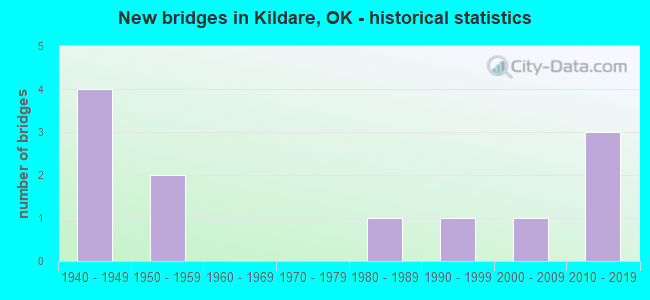
- New bridges - historical statistics
- 41940-1949
- 21950-1959
- 11980-1989
- 11990-1999
- 12000-2009
- 32010-2019
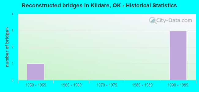
- Reconstructed bridges - Historical Statistics
- 11950-1959
- 01960-1969
- 01970-1979
- 01980-1989
- 31990-1999
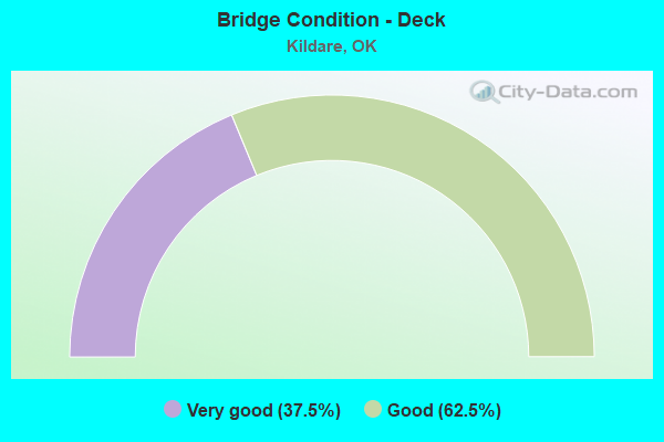
- Bridge Condition - Deck
- 37.5%Very good
- 62.5%Good
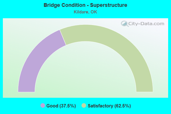
- Bridge Condition - Superstructure
- 37.5%Good
- 62.5%Satisfactory
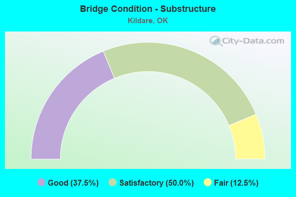
- Bridge Condition - Substructure
- 37.5%Good
- 50.0%Satisfactory
- 12.5%Fair
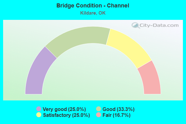
- Bridge Condition - Channel
- 25.0%Very good
- 33.3%Good
- 25.0%Satisfactory
- 16.7%Fair
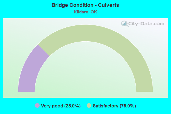
- Bridge Condition - Culverts
- 25.0%Very good
- 75.0%Satisfactory
Find on map >> Show street view
Structure Number: 8712, Location: 5.1 MI E US81 (Lat: 34.967586, Lng: -97.866256), Route carried "on" structure: State highway 19, Year Built: 1940, Year Reconstructed: 2001, Status: Open, Structure Length: 0.94m (3.08ft), Average Daily Traffic: 2,800 (year 2020), Truck Traffic: 15%, Average Future Daily Traffic: 4,480 (year 2040), Design Load: H 20, Features Intersected: CREEK
Minimum Vertical Clearance: 30+ m (98+ ft), Kilometerpoint: 12.740, Lanes on structure: 2, Owner: State Highway Agency, Approaching Roadway Width: 11.0m (36.1ft), Skew: 4 degrees, Material/Design: Concrete, Design/Construction: Culvert, Number Of Spans In Main Unit: 2, Length of Maximum Span: 3.0m (9.8ft)
Condition: Channel: Very good, Culverts: Very good, Operating Rating: 32.7 metric tons, Method Used To Determine Operating Rating: Load Factor (LF), Inventory Rating: 19.6 metric tons, Method Used To Determine Inventory Rating: Load Factor (LF), Structural Evaluation: Somewhat better than minimum adequacy, Waterway Adequacy: Equal to present desirable criteria, Approach Roadway Alignment: Equal to present desirable criteria, Length Of Structure Improvement: 0.94m (3.08ft), Designated Inspection Frequency: Every 24 months, Inspection Date: July 2021, Bridge Improvement Cost: $230,000, Roadway Improvement Cost: $380,000, Total Project Cost: $644,000 ( Estimate for 2015)
Find on map >> Show street view
Structure Number: 8948, Location: 1.7W 3S .5W OF NEWKIRK (Lat: 36.839911, Lng: -97.094869), Route carried "on" structure: County highway E0120, Year Built: 1940, Year Reconstructed: 2004, Status: Posted for load, Structure Length: 1.46m (4.79ft), Average Daily Traffic: 50 (year 2020), Truck Traffic: 10%, Average Future Daily Traffic: 80 (year 2040), Design Load: H 10, Features Intersected: BOIS D'ARC CREEK
Minimum Vertical Clearance: 30+ m (98+ ft), Kilometerpoint: 0.805, Lanes on structure: 2, Owner: County Highway Agency, Approaching Roadway Width: 6.1m (20.0ft), Material/Design: Steel, Design/Construction: Stringer/Multi-beam, Number Of Spans In Main Unit: 1, Length of Maximum Span: 13.7m (44.9ft), Curb-To-Curb Width: 6.6m (21.7ft), Out-to-Out Width: 6.7m (22.0ft)
Condition: Deck: Good, Superstructure: Good, Substructure: Good, Channel: Satisfactory, Operating Rating: 10.9 metric tons, Method Used To Determine Operating Rating: Load Factor (LF), Inventory Rating: 6.4 metric tons, Method Used To Determine Inventory Rating: Load Factor (LF), Structural Evaluation: High priority of replacement, Deck Geometry: Somewhat better than minimum adequacy, Waterway Adequacy: Equal to present minimum criteria, Approach Roadway Alignment: Equal to present desirable criteria, Bridge Posting: Required (Relationship of Operating Rating to Maximum Legal Load: > 39.9% below), Length Of Structure Improvement: 4.26m (13.98ft), Designated Inspection Frequency: Every 24 months, Inspection Date: October 2020, Bridge Improvement Cost: $109,000, Roadway Improvement Cost: $60,000, Total Project Cost: $225,000 ( Estimate for 2015), Deck Structure Type: Concrete Cast-file-Place, Wearing Surface/Protective System: Wearing Surface: Gravel
Find on map >> Show street view
Structure Number: 8949, Location: .9 N & .5 E OF MCLOUD (Lat: 35.449219, Lng: -97.083428), Route carried "on" structure: County highway E1080, Year Built: 1940, Year Reconstructed: 1955, Status: Open, Structure Length: 1.32m (4.33ft), Average Daily Traffic: 500 (year 2020), Truck Traffic: 10%, Average Future Daily Traffic: 800 (year 2040), Design Load: HS 20, Features Intersected: CREEK
Minimum Vertical Clearance: 30+ m (98+ ft), Kilometerpoint: 0.483, Lanes on structure: 2, Owner: County Highway Agency, Approaching Roadway Width: 7.9m (25.9ft), Material/Design: Concrete, Design/Construction: Culvert, Number Of Spans In Main Unit: 4, Length of Maximum Span: 3.0m (9.8ft)
Condition: Channel: Good, Culverts: Satisfactory, Operating Rating: 32.7 metric tons, Method Used To Determine Operating Rating: Field evaluation and documented engineering judgment, Inventory Rating: 19.1 metric tons, Method Used To Determine Inventory Rating: Field evaluation and documented engineering judgment, Structural Evaluation: Somewhat better than minimum adequacy, Waterway Adequacy: Equal to present minimum criteria, Approach Roadway Alignment: Equal to present desirable criteria, Length Of Structure Improvement: 4.08m (13.39ft), Designated Inspection Frequency: Every 24 months, Inspection Date: April 2021, Bridge Improvement Cost: $100,000, Roadway Improvement Cost: $75,000, Total Project Cost: $225,000 ( Estimate for 2015), Wearing Surface/Protective System: Wearing Surface: Bituminous
Find on map >> Show street view
Structure Number: 13588, Location: 3N 2.6W OF CARMEN (Lat: 36.623172, Lng: -98.516339), Route carried "on" structure: County highway E0270, Year Built: 1956, Status: Posted for load, Structure Length: 1.07m (3.51ft), Average Daily Traffic: 100 (year 2020), Truck Traffic: 10%, Average Future Daily Traffic: 160 (year 2040), Design Load: HS 20, Features Intersected: CREEK
Minimum Vertical Clearance: 30+ m (98+ ft), Kilometerpoint: 0.644, Lanes on structure: 2, Owner: County Highway Agency, Approaching Roadway Width: 6.7m (22.0ft), Material/Design: Steel, Design/Construction: Stringer/Multi-beam, Number Of Spans In Main Unit: 1, Length of Maximum Span: 10.1m (33.1ft), Curb-To-Curb Width: 7.3m (24.0ft), Out-to-Out Width: 7.3m (24.0ft)
Condition: Deck: Good, Superstructure: Satisfactory, Substructure: Fair, Channel: Fair, Operating Rating: 20.5 metric tons, Method Used To Determine Operating Rating: Load Factor (LF), Inventory Rating: 12.2 metric tons, Method Used To Determine Inventory Rating: Load Factor (LF), Structural Evaluation: Meets minimum limits, Deck Geometry: Equal to present minimum criteria, Waterway Adequacy: Equal to present desirable criteria, Approach Roadway Alignment: Equal to present desirable criteria, Bridge Posting: Required (Relationship of Operating Rating to Maximum Legal Load: > 39.9% below), Length Of Structure Improvement: 3.58m (11.75ft), Designated Inspection Frequency: Every 12 months, Inspection Date: Febuary 2021, Bridge Improvement Cost: $183,000, Roadway Improvement Cost: $100,000, Total Project Cost: $290,000 ( Estimate for 2015), Deck Structure Type: Corrugated Steel, Wearing Surface/Protective System: Wearing Surface: Bituminous
Find on map >> Show street view
Structure Number: 13606, Location: 9. MI N JCT US 60 (Lat: 36.815767, Lng: -97.067158), Route carried "on" structure: US 77, Year Built: 1956, Status: Open, Structure Length: 1.12m (3.67ft), Average Daily Traffic: 8,800 (year 2020), Truck Traffic: 16%, Average Future Daily Traffic: 14,080 (year 2040), Design Load: HS 20, Features Intersected: SPRING CREEK
Minimum Vertical Clearance: 30+ m (98+ ft), Kilometerpoint: 15.205, Lanes on structure: 4, Base Highway Network: Yes, Owner: State Highway Agency, Approaching Roadway Width: 18.3m (60.0ft), Skew: 13 degrees, Material/Design: Concrete, Design/Construction: Culvert, Number Of Spans In Main Unit: 3, Length of Maximum Span: 3.0m (9.8ft)
Condition: Channel: Satisfactory, Culverts: Satisfactory, Operating Rating: 85.2 metric tons, Method Used To Determine Operating Rating: Load Factor (LF), Inventory Rating: 51.1 metric tons, Method Used To Determine Inventory Rating: Load Factor (LF), Structural Evaluation: Equal to present minimum criteria, Waterway Adequacy: Equal to present minimum criteria, Approach Roadway Alignment: Equal to present desirable criteria, Length Of Structure Improvement: 1.19m (3.90ft), Designated Inspection Frequency: Every 24 months, Inspection Date: October 2021, Bridge Improvement Cost: $259,000, Roadway Improvement Cost: $428,000, Total Project Cost: $727,000 ( Estimate for 2015)
Find on map >> Show street view
Structure Number: 20302, Location: 1.1 MI W JCT US 77 (Lat: 36.810692, Lng: -97.086550), Route carried "on" structure: State highway 11, Year Built: 1982, Status: Open, Structure Length: 5.07m (16.63ft), Average Daily Traffic: 2,500 (year 2020), Truck Traffic: 16%, Average Future Daily Traffic: 4,000 (year 2040), Design Load: HS 20, Features Intersected: SPRING CREEK
Minimum Vertical Clearance: 30+ m (98+ ft), Kilometerpoint: 17.490, Lanes on structure: 2, Base Highway Network: Yes, Owner: State Highway Agency, Approaching Roadway Width: 13.4m (44.0ft), Skew: 2 degrees, Material/Design: Prestressed concrete, Design/Construction: Stringer/Multi-beam, Number Of Spans In Main Unit: 3, Length of Maximum Span: 16.8m (55.1ft), Curb-To-Curb Width: 13.0m (42.7ft), Out-to-Out Width: 13.9m (45.6ft)
Condition: Deck: Good, Superstructure: Satisfactory, Substructure: Satisfactory, Channel: Good, Operating Rating: 54.4 metric tons, Method Used To Determine Operating Rating: Load Factor (LF), Inventory Rating: 32.7 metric tons, Method Used To Determine Inventory Rating: Load Factor (LF), Structural Evaluation: Equal to present minimum criteria, Deck Geometry: Equal to present minimum criteria, Waterway Adequacy: Better than present minimum criteria, Approach Roadway Alignment: Equal to present desirable criteria, Length Of Structure Improvement: 8.15m (26.74ft), Designated Inspection Frequency: Every 24 months, Inspection Date: October 2021, Bridge Improvement Cost: $671,000, Roadway Improvement Cost: $1,107,000, Total Project Cost: $1,879,000 ( Estimate for 2015), Deck Structure Type: Concrete Cast-file-Place, Wearing Surface/Protective System: Wearing Surface: Low Slump Concrete
Find on map >> Show street view
Structure Number: 24829, Location: 2W 0.4N OF KILDARE (Lat: 36.814772, Lng: -97.085278), Route carried "on" structure: County highway N3320, Year Built: 1997, Status: Open, Structure Length: 1.01m (3.31ft), Average Daily Traffic: 50 (year 2020), Truck Traffic: 10%, Average Future Daily Traffic: 80 (year 2040), Features Intersected: SPRING CREEK
Minimum Vertical Clearance: 30+ m (98+ ft), Kilometerpoint: 1.127, Lanes on structure: 2, Owner: County Highway Agency, Approaching Roadway Width: 6.1m (20.0ft), Material/Design: Steel, Design/Construction: Stringer/Multi-beam, Number Of Spans In Main Unit: 1, Length of Maximum Span: 9.8m (32.2ft), Curb-To-Curb Width: 6.5m (21.3ft), Out-to-Out Width: 6.7m (22.0ft)
Condition: Deck: Good, Superstructure: Satisfactory, Substructure: Satisfactory, Channel: Very good, Operating Rating: 68.9 metric tons, Method Used To Determine Operating Rating: Load Factor (LF), Inventory Rating: 40.8 metric tons, Method Used To Determine Inventory Rating: Load Factor (LF), Structural Evaluation: Equal to present minimum criteria, Deck Geometry: Somewhat better than minimum adequacy, Waterway Adequacy: Somewhat better than minimum adequacy, Approach Roadway Alignment: Equal to present desirable criteria, Length Of Structure Improvement: 3.47m (11.38ft), Designated Inspection Frequency: Every 24 months, Inspection Date: October 2020, Bridge Improvement Cost: $177,000, Roadway Improvement Cost: $97,000, Total Project Cost: $281,000 ( Estimate for 2015), Deck Structure Type: Concrete Cast-file-Place, Wearing Surface/Protective System: Wearing Surface: Gravel
Find on map >> Show street view
Structure Number: 25231, Location: 3.1W .9S OF KILDARE (Lat: 36.796208, Lng: -97.055881), Route carried "on" structure: County highway E0150, Year Built: 1940, Year Reconstructed: 1997, Status: Open, Structure Length: 1.81m (5.94ft), Average Daily Traffic: 24 (year 2020), Truck Traffic: 10%, Average Future Daily Traffic: 38 (year 2040), Features Intersected: BOIS D'ARC CREEK
Minimum Vertical Clearance: 30+ m (98+ ft), Kilometerpoint: 1.448, Lanes on structure: 2, Owner: County Highway Agency, Approaching Roadway Width: 6.7m (22.0ft), Skew: 4 degrees, Material/Design: Steel, Design/Construction: Stringer/Multi-beam, Number Of Spans In Main Unit: 1, Length of Maximum Span: 17.9m (58.7ft), Curb-To-Curb Width: 7.1m (23.3ft), Out-to-Out Width: 7.3m (24.0ft)
Condition: Deck: Good, Superstructure: Satisfactory, Substructure: Satisfactory, Channel: Satisfactory, Operating Rating: 59.0 metric tons, Method Used To Determine Operating Rating: Load Factor (LF), Inventory Rating: 35.4 metric tons, Method Used To Determine Inventory Rating: Load Factor (LF), Structural Evaluation: Equal to present minimum criteria, Deck Geometry: Somewhat better than minimum adequacy, Waterway Adequacy: Equal to present minimum criteria, Approach Roadway Alignment: Equal to present desirable criteria, Length Of Structure Improvement: 4.84m (15.88ft), Designated Inspection Frequency: Every 24 months, Inspection Date: October 2020, Bridge Improvement Cost: $123,000, Roadway Improvement Cost: $68,000, Total Project Cost: $225,000 ( Estimate for 2015), Deck Structure Type: Concrete Cast-file-Place, Wearing Surface/Protective System: Wearing Surface: Monolithic Concrete
Find on map >> Show street view
Structure Number: 28487, Location: 2W.3S OF KILDARE (Lat: 36.806017, Lng: -97.085256), Route carried "on" structure: County highway N3320, Year Built: 2004, Status: Open, Structure Length: 0.67m (2.20ft), Average Daily Traffic: 25 (year 2020), Truck Traffic: 10%, Average Future Daily Traffic: 40 (year 2040), Features Intersected: CREEK
Minimum Vertical Clearance: 30+ m (98+ ft), Kilometerpoint: 0.483, Lanes on structure: 2, Owner: County Highway Agency, Approaching Roadway Width: 6.6m (21.7ft), Material/Design: Steel, Design/Construction: Culvert, Number Of Spans In Main Unit: 2, Length of Maximum Span: 2.9m (9.5ft), Curb-To-Curb Width: 8.8m (28.9ft), Out-to-Out Width: 9.1m (29.9ft)
Condition: Channel: Good, Culverts: Satisfactory, Operating Rating: 32.7 metric tons, Method Used To Determine Operating Rating: Allowable Stress (AS), Inventory Rating: 19.1 metric tons, Method Used To Determine Inventory Rating: Allowable Stress (AS), Structural Evaluation: Somewhat better than minimum adequacy, Deck Geometry: Better than present minimum criteria, Waterway Adequacy: Better than present minimum criteria, Approach Roadway Alignment: Better than present minimum criteria, Length Of Structure Improvement: 0.80m (2.62ft), Designated Inspection Frequency: Every 24 months, Inspection Date: October 2020, Bridge Improvement Cost: $370,000, Roadway Improvement Cost: $185,000, Total Project Cost: $592,000 ( Estimate for 2015)
Find on map >> Show street view
Structure Number: 31246, Location: 2.9W 1N OF KILDARE (Lat: 36.825278, Lng: -97.098333), Route carried "on" structure: County highway E0130, Year Built: 2014, Status: Open, Structure Length: 2.16m (7.09ft), Average Daily Traffic: 100 (year 2020), Truck Traffic: 10%, Average Future Daily Traffic: 160 (year 2040), Design Load: HS 20, Features Intersected: BOIS D'ARC CREEK
Minimum Vertical Clearance: 30+ m (98+ ft), Kilometerpoint: 0.483, Lanes on structure: 2, Owner: County Highway Agency, Approaching Roadway Width: 7.3m (24.0ft), Material/Design: Steel, Design/Construction: Stringer/Multi-beam, Number Of Spans In Main Unit: 1, Length of Maximum Span: 21.6m (70.9ft), Curb-To-Curb Width: 7.9m (25.9ft), Out-to-Out Width: 8.2m (26.9ft)
Condition: Deck: Very good, Superstructure: Good, Substructure: Good, Channel: Fair, Operating Rating: 67.1 metric tons, Method Used To Determine Operating Rating: Load Factor (LF), Inventory Rating: 39.9 metric tons, Method Used To Determine Inventory Rating: Load Factor (LF), Structural Evaluation: Better than present minimum criteria, Deck Geometry: Equal to present minimum criteria, Waterway Adequacy: Better than present minimum criteria, Approach Roadway Alignment: Equal to present desirable criteria, Designated Inspection Frequency: Every 24 months, Inspection Date: October 2020, Deck Structure Type: Concrete Cast-file-Place, Wearing Surface/Protective System: Wearing Surface: Monolithic Concrete
Find on map >> Show street view
Structure Number: 31432, Location: 1N 1.9W OF KILDARE (Lat: 36.825278, Lng: -97.083056), Route carried "on" structure: County highway E0130, Year Built: 2015, Status: Open, Structure Length: 1.07m (3.51ft), Average Daily Traffic: 50 (year 2020), Truck Traffic: 10%, Average Future Daily Traffic: 80 (year 2040), Design Load: HS 20, Features Intersected: SPRING CREEK
Minimum Vertical Clearance: 30+ m (98+ ft), Kilometerpoint: 0.322, Lanes on structure: 2, Owner: County Highway Agency, Approaching Roadway Width: 7.3m (24.0ft), Material/Design: Steel, Design/Construction: Stringer/Multi-beam, Number Of Spans In Main Unit: 1, Length of Maximum Span: 10.7m (35.1ft), Curb-To-Curb Width: 8.0m (26.2ft), Out-to-Out Width: 8.1m (26.6ft)
Condition: Deck: Very good, Superstructure: Satisfactory, Substructure: Satisfactory, Channel: Good, Operating Rating: 90.7 metric tons, Method Used To Determine Operating Rating: Load Factor (LF), Inventory Rating: 59.0 metric tons, Method Used To Determine Inventory Rating: Load Factor (LF), Structural Evaluation: Equal to present minimum criteria, Deck Geometry: Equal to present minimum criteria, Waterway Adequacy: Better than present minimum criteria, Approach Roadway Alignment: Equal to present desirable criteria, Designated Inspection Frequency: Every 24 months, Inspection Date: March 2021, Deck Structure Type: Concrete Cast-file-Place, Wearing Surface/Protective System: Wearing Surface: Monolithic Concrete
Find on map >> Show street view
Structure Number: 31909, Location: 2W .6N OF KILDARE (Lat: 36.817869, Lng: -97.085228), Route carried "on" structure: County highway N3320, Year Built: 2017, Status: Open, Structure Length: 1.07m (3.51ft), Average Daily Traffic: 50 (year 2020), Truck Traffic: 10%, Average Future Daily Traffic: 80 (year 2040), Design Load: HS 20, Features Intersected: SPRING CREEK
Minimum Vertical Clearance: 30+ m (98+ ft), Kilometerpoint: 0.805, Lanes on structure: 2, Owner: County Highway Agency, Approaching Roadway Width: 7.3m (24.0ft), Material/Design: Steel, Design/Construction: Stringer/Multi-beam, Number Of Spans In Main Unit: 1, Length of Maximum Span: 10.7m (35.1ft), Curb-To-Curb Width: 8.3m (27.2ft), Out-to-Out Width: 8.5m (27.9ft)
Condition: Deck: Very good, Superstructure: Good, Substructure: Good, Channel: Very good, Operating Rating: 90.7 metric tons, Method Used To Determine Operating Rating: Load Factor (LF), Inventory Rating: 59.9 metric tons, Method Used To Determine Inventory Rating: Load Factor (LF), Structural Evaluation: Better than present minimum criteria, Deck Geometry: Equal to present minimum criteria, Waterway Adequacy: Equal to present desirable criteria, Approach Roadway Alignment: Equal to present desirable criteria, Designated Inspection Frequency: Every 24 months, Inspection Date: January 2021, Deck Structure Type: Concrete Cast-file-Place, Wearing Surface/Protective System: Wearing Surface: Monolithic Concrete