Bridge Statistics for Lake Darby, Ohio (OH)
Condition, Traffic, Stress, Structural Evaluation, Project Costs
- National Bridge Inventory (NBI) Statistics
- 14Number of bridges
- 282ft / 86.4mTotal length
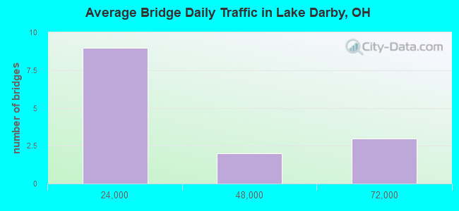
- 291,812Total average daily traffic
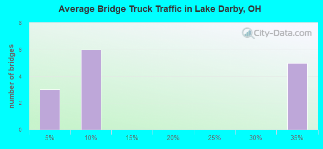
- 82,023Total average daily truck traffic
- National Bridge Inventory (NBI) Registered Bridges for Lake Darby
- No street view available for this location
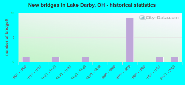
- New bridges - historical statistics
- 11900-1909
- 11920-1929
- 11940-1949
- 91970-1979
- 11990-1999
- 12000-2009
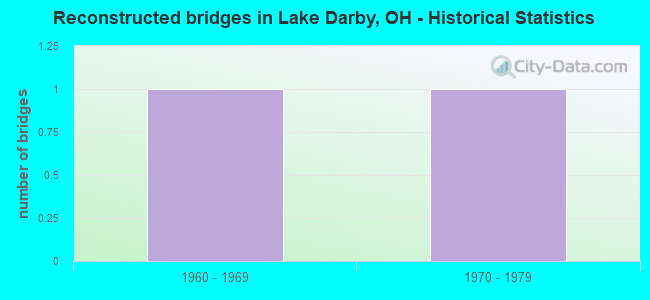
- Reconstructed bridges - Historical Statistics
- 11960-1969
- 11970-1979
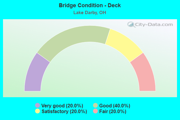
- Bridge Condition - Deck
- 20.0%Very good
- 40.0%Good
- 20.0%Satisfactory
- 20.0%Fair
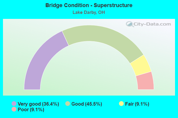
- Bridge Condition - Superstructure
- 36.4%Very good
- 45.5%Good
- 9.1%Fair
- 9.1%Poor
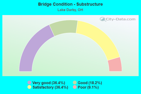
- Bridge Condition - Substructure
- 36.4%Very good
- 18.2%Good
- 36.4%Satisfactory
- 9.1%Poor
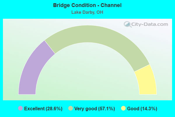
- Bridge Condition - Channel
- 28.6%Excellent
- 57.1%Very good
- 14.3%Good
Find on map >> Show street view
Structure Number: 2503727, Location: 0.8 MI. E. OF MADISON CO. (Lat: 39.980831, Lng: -83.234581), Route carried "on" structure: County highway C0028, Year Built: 1970, Status: Open, Structure Length: 13.65m (44.78ft), Average Daily Traffic: 1,588 (year 2017), Truck Traffic: 4%, Average Future Daily Traffic: 2,204 (year 2037), Design Load: H 15, Features Intersected: IR-70, Facility Carried by Structure: ROBERTS RD
Minimum Vertical Clearance: 30+ m (98+ ft), Kilometerpoint: 1.524, Lanes on structure: 2, Lanes under structure: 6, Owner: State Highway Agency, Approaching Roadway Width: 11.0m (36.1ft), Skew: 5 degrees, Material/Design: Steel continuous, Design/Construction: Stringer/Multi-beam, Number Of Spans In Main Unit: 4, Length of Maximum Span: 40.5m (132.9ft), Curb-To-Curb Width: 8.5m (27.9ft), Out-to-Out Width: 10.4m (34.1ft)
Condition: Deck: Satisfactory, Superstructure: Good, Substructure: Satisfactory, Operating Rating: 35.6 metric tons, Method Used To Determine Operating Rating: Load and Resistance Factor Rating (LRFR) rating reported by rating factor(RF) method using HL-93 loadings, Inventory Rating: 29.2 metric tons, Method Used To Determine Inventory Rating: Load and Resistance Factor Rating (LRFR) rating reported by rating factor(RF) method using HL-93 loadings, Structural Evaluation: Equal to present minimum criteria, Deck Geometry: Somewhat better than minimum adequacy, Underclear: High priority of corrective action, Approach Roadway Alignment: Equal to present desirable criteria, Designated Inspection Frequency: Every 12 months, Inspection Date: June 2021, Deck Structure Type: Concrete Cast-file-Place, Wearing Surface/Protective System: Wearing Surface: Latex Concrete
Find on map >> Show street view
Structure Number: 2503751, Location: 1.41 MI. E OF MADISON CO. (Lat: 39.980231, Lng: -83.222289), Route carried "on" structure: County highway C0012, Year Built: 1970, Status: Open, Structure Length: 15.38m (50.46ft), Average Daily Traffic: 2,397 (year 2017), Truck Traffic: 5%, Average Future Daily Traffic: 3,327 (year 2037), Design Load: H 15, Features Intersected: IR-70, Facility Carried by Structure: AMITY RD
Minimum Vertical Clearance: 30+ m (98+ ft), Kilometerpoint: 7.451, Lanes on structure: 2, Lanes under structure: 6, Owner: State Highway Agency, Approaching Roadway Width: 11.0m (36.1ft), Skew: 5 degrees, Material/Design: Steel continuous, Design/Construction: Stringer/Multi-beam, Number Of Spans In Main Unit: 4, Length of Maximum Span: 45.7m (149.9ft), Curb-To-Curb Width: 8.5m (27.9ft), Out-to-Out Width: 10.4m (34.1ft)
Condition: Deck: Fair, Superstructure: Very good, Substructure: Satisfactory, Operating Rating: 32.4 metric tons, Method Used To Determine Operating Rating: Load and Resistance Factor Rating (LRFR) rating reported by rating factor(RF) method using HL-93 loadings, Inventory Rating: 25.9 metric tons, Method Used To Determine Inventory Rating: Load and Resistance Factor Rating (LRFR) rating reported by rating factor(RF) method using HL-93 loadings, Structural Evaluation: Equal to present minimum criteria, Deck Geometry: Meets minimum limits, Underclear: High priority of corrective action, Approach Roadway Alignment: Equal to present desirable criteria, Designated Inspection Frequency: Every 12 months, Inspection Date: June 2021, Deck Structure Type: Concrete Cast-file-Place, Wearing Surface/Protective System: Wearing Surface: Latex Concrete
Find on map >> Show street view
Structure Number: 2503786, Location: 2.61 MI. E. OF MADISON CO (Lat: 39.979239, Lng: -83.200139), Route carried "on" structure: County highway C0036, Year Built: 1970, Status: Open, Structure Length: 9.02m (29.59ft), Average Daily Traffic: 417 (year 2017), Truck Traffic: 7%, Average Future Daily Traffic: 579 (year 2037), Design Load: H 15, Features Intersected: IR-70, Facility Carried by Structure: JONES RD
Minimum Vertical Clearance: 30+ m (98+ ft), Kilometerpoint: 0.587, Lanes on structure: 2, Lanes under structure: 6, Owner: State Highway Agency, Approaching Roadway Width: 11.0m (36.1ft), Skew: 1 degrees, Material/Design: Steel continuous, Design/Construction: Stringer/Multi-beam, Number Of Spans In Main Unit: 4, Length of Maximum Span: 26.1m (85.6ft), Curb-To-Curb Width: 8.5m (27.9ft), Out-to-Out Width: 10.4m (34.1ft)
Condition: Deck: Fair, Superstructure: Good, Substructure: Satisfactory, Operating Rating: 38.9 metric tons, Method Used To Determine Operating Rating: Load and Resistance Factor Rating (LRFR) rating reported by rating factor(RF) method using HL-93 loadings, Inventory Rating: 29.2 metric tons, Method Used To Determine Inventory Rating: Load and Resistance Factor Rating (LRFR) rating reported by rating factor(RF) method using HL-93 loadings, Structural Evaluation: Equal to present minimum criteria, Deck Geometry: Somewhat better than minimum adequacy, Underclear: High priority of corrective action, Approach Roadway Alignment: Meets minimum limits, Designated Inspection Frequency: Every 12 months, Inspection Date: June 2021, Deck Structure Type: Concrete Cast-file-Place, Wearing Surface/Protective System: Wearing Surface: Integral Concrete
Find on map >> Show street view
Structure Number: 2533685, Location: 0.65 MI NORTH OF BROAD ST (Lat: 39.957689, Lng: -83.232561), Route carried "on" structure: County highway C0140, Year Built: 1905, Year Reconstructed: 1973, Status: Open, Structure Length: 1.89m (6.20ft), Average Daily Traffic: 2,861 (year 2015), Truck Traffic: 5%, Average Future Daily Traffic: 3,971 (year 2035), Design Load: HS 20, Features Intersected: NORFOLK SO RR (HUBBARD), Facility Carried by Structure: HUBBARD RD
Minimum Vertical Clearance: 30+ m (98+ ft), Kilometerpoint: 12.070, Lanes on structure: 2, Owner: County Highway Agency, Approaching Roadway Width: 14.0m (45.9ft), Material/Design: Prestressed concrete, Design/Construction: Box Beam or Girders - Multiple, Number Of Spans In Main Unit: 1, Length of Maximum Span: 17.1m (56.1ft), Curb-To-Curb Width: 13.4m (44.0ft), Out-to-Out Width: 14.0m (45.9ft)
Condition: Deck: Good, Superstructure: Very good, Substructure: Good, Operating Rating: 45.4 metric tons, Method Used To Determine Operating Rating: Load Factor (LF) rating reported by rating factor (RF) method using MS18 loading, Inventory Rating: 22.7 metric tons, Method Used To Determine Inventory Rating: Load Factor (LF) rating reported by rating factor (RF) method using MS18 loading, Structural Evaluation: Equal to present minimum criteria, Deck Geometry: Better than present minimum criteria, Underclear: Somewhat better than minimum adequacy, Approach Roadway Alignment: Equal to present minimum criteria, Designated Inspection Frequency: Every 24 months, Inspection Date: December 2021, Deck Structure Type: Concrete Cast-file-Place, Wearing Surface/Protective System: Wearing Surface: Bituminous
Find on map >> Show street view
Structure Number: 2534045, Location: AT MADISON COUNTY LINE (Lat: 39.979950, Lng: -83.249119), Route carried "on" structure: County highway C0028, Year Built: 1976, Status: Open, Structure Length: 6.25m (20.51ft), Average Daily Traffic: 1,798 (year 2015), Truck Traffic: 3%, Average Future Daily Traffic: 2,496 (year 2035), Design Load: HS 20+Mod, Features Intersected: BIG DARBY CREEK(ROBERTS), Facility Carried by Structure: ROBERTS RD
Minimum Vertical Clearance: 30+ m (98+ ft), Kilometerpoint: 0.016, Lanes on structure: 2, Owner: County Highway Agency, Approaching Roadway Width: 13.7m (44.9ft), Material/Design: Steel continuous, Design/Construction: Stringer/Multi-beam, Number Of Spans In Main Unit: 3, Length of Maximum Span: 26.8m (87.9ft), Curb-To-Curb Width: 13.4m (44.0ft), Out-to-Out Width: 13.4m (44.0ft)
Condition: Deck: Satisfactory, Superstructure: Very good, Substructure: Good, Channel: Very good, Operating Rating: 64.8 metric tons, Method Used To Determine Operating Rating: Load Factor (LF) rating reported by rating factor (RF) method using MS18 loading, Inventory Rating: 38.9 metric tons, Method Used To Determine Inventory Rating: Load Factor (LF) rating reported by rating factor (RF) method using MS18 loading, Structural Evaluation: Better than present minimum criteria, Deck Geometry: Equal to present desirable criteria, Waterway Adequacy: Equal to present desirable criteria, Approach Roadway Alignment: Equal to present desirable criteria, Designated Inspection Frequency: Every 12 months, Inspection Date: August 2021, Deck Structure Type: Concrete Cast-file-Place, Wearing Surface/Protective System: Wearing Surface: Bituminous
Find on map >> Show street view
Structure Number: 2535602, Location: 0.7 MI. SOUTH OF FEDER RD (Lat: 39.960219, Lng: -83.204450), Route carried "on" structure: County highway C0012, Year Built: 1996, Status: Open, Structure Length: 0.85m (2.79ft), Average Daily Traffic: 1,207 (year 2015), Truck Traffic: 5%, Average Future Daily Traffic: 1,675 (year 2035), Design Load: HS 20+Mod, Features Intersected: MCCOY DITCH (AMITY), Facility Carried by Structure: AMITY RD
Minimum Vertical Clearance: 30+ m (98+ ft), Kilometerpoint: 4.731, Lanes on structure: 2, Owner: County Highway Agency, Approaching Roadway Width: 12.2m (40.0ft), Skew: 3 degrees, Material/Design: Concrete, Design/Construction: Frame, Number Of Spans In Main Unit: 1, Length of Maximum Span: 7.9m (25.9ft), Curb-To-Curb Width: 11.1m (36.4ft), Out-to-Out Width: 11.1m (36.4ft)
Condition: Deck: Very good, Superstructure: Very good, Substructure: Very good, Channel: Good, Operating Rating: 40.8 metric tons, Method Used To Determine Operating Rating: Field evaluation and documented engineering judgment, Inventory Rating: 32.7 metric tons, Method Used To Determine Inventory Rating: Field evaluation and documented engineering judgment, Structural Evaluation: Equal to present desirable criteria, Deck Geometry: Equal to present minimum criteria, Waterway Adequacy: Superior to present desirable criteria, Approach Roadway Alignment: Equal to present desirable criteria, Designated Inspection Frequency: Every 24 months, Inspection Date: December 2021, Deck Structure Type: Concrete Cast-file-Place, Wearing Surface/Protective System: Wearing Surface: Bituminous, Membrane: Built-up, Deck Protection: Epoxy Coated Reinforcing
Find on map >> Show street view
Structure Number: 2535882, Location: W. OF AMITY ON CNTY. LINE (Lat: 40.009861, Lng: -83.252300), Route carried "on" structure: County highway C0150, Year Built: 2001, Status: Open, Structure Length: 9.14m (29.99ft), Average Daily Traffic: 385 (year 2015), Truck Traffic: 8%, Average Future Daily Traffic: 534 (year 2035), Design Load: HS 25 or greater, Features Intersected: BIG DARBY CR (BEACH RD), Facility Carried by Structure: BEACH ROAD
Minimum Vertical Clearance: 30+ m (98+ ft), Kilometerpoint: 0.000, Lanes on structure: 2, Owner: County Highway Agency, Approaching Roadway Width: 10.4m (34.1ft), Material/Design: Concrete, Design/Construction: Stayed Girder, Number Of Spans In Main Unit: 3, Length of Maximum Span: 64.9m (212.9ft), Curb-To-Curb Width: 10.2m (33.5ft), Out-to-Out Width: 12.6m (41.3ft)
Condition: Deck: Very good, Superstructure: Good, Substructure: Very good, Channel: Very good, Operating Rating: 42.1 metric tons, Method Used To Determine Operating Rating: Load Factor (LF) rating reported by rating factor (RF) method using MS18 loading, Inventory Rating: 32.4 metric tons, Method Used To Determine Inventory Rating: Load Factor (LF) rating reported by rating factor (RF) method using MS18 loading, Structural Evaluation: Better than present minimum criteria, Deck Geometry: Better than present minimum criteria, Waterway Adequacy: Superior to present desirable criteria, Approach Roadway Alignment: Superior to present desirable criteria, Designated Inspection Frequency: Every 12 months, Critical Feature Inspection Frequency: Every 24 months, Inspection Date: August 2021, Critical Feature Inspection Date: August 2021, Deck Structure Type: Concrete Cast-file-Place, Wearing Surface/Protective System: Wearing Surface: Integral Concrete, Deck Protection: Epoxy Coated Reinforcing
Find on map >> Show street view
Structure Number: 4901029, Location: 1.98 MI N OF SR142 (Lat: 39.947319, Lng: -83.236561), Route carried "on" structure: US 40, Year Built: 1940, Year Reconstructed: 1984, Status: Open, Structure Length: 15.64m (51.31ft), Average Daily Traffic: 9,659 (year 2015), Truck Traffic: 2%, Average Future Daily Traffic: 13,407 (year 2037), Design Load: HS 20+Mod, Features Intersected: BIG DARBY CREEK
Minimum Vertical Clearance: 30+ m (98+ ft), Kilometerpoint: 25.910, Lanes on structure: 4, Owner: State Highway Agency, Approaching Roadway Width: 19.5m (64.0ft), Skew: 32 degrees, Material/Design: Concrete, Design/Construction: Arch - Deck, Number Of Spans In Main Unit: 2, Number Of Approach Spans: 6, Length of Maximum Span: 49.1m (161.1ft), Curb-To-Curb Width: 19.5m (64.0ft), Out-to-Out Width: 19.5m (64.0ft)
Condition: Deck: Good, Superstructure: Fair, Substructure: Satisfactory, Channel: Very good, Operating Rating: 35.6 metric tons, Method Used To Determine Operating Rating: Load Factor (LF) rating reported by rating factor (RF) method using MS18 loading, Inventory Rating: 32.4 metric tons, Method Used To Determine Inventory Rating: Load Factor (LF) rating reported by rating factor (RF) method using MS18 loading, Structural Evaluation: Somewhat better than minimum adequacy, Deck Geometry: Better than present minimum criteria, Waterway Adequacy: Equal to present desirable criteria, Approach Roadway Alignment: Equal to present desirable criteria, Designated Inspection Frequency: Every 12 months, Inspection Date: July 2021, Deck Structure Type: Concrete Cast-file-Place, Wearing Surface/Protective System: Wearing Surface: Bituminous, Membrane: Built-up
Find on map >> Show street view
Structure Number: 4902858, Location: 0.42 MI. E. OF SR142 (Lat: 39.980719, Lng: -83.249739), Route carried "on" structure: Interstate 70, Year Built: 1970, Status: Open, Structure Length: 6.87m (22.54ft), Average Daily Traffic: 32,533 (year 2015), Truck Traffic: 31%, Average Future Daily Traffic: 45,156 (year 2035), Design Load: HS 20+Mod, Features Intersected: BIG DARBY CREEK
Minimum Vertical Clearance: 30+ m (98+ ft), Kilometerpoint: 25.041, Lanes on structure: 3, Base Highway Network: Yes, Owner: State Highway Agency, Approaching Roadway Width: 17.7m (58.1ft), Material/Design: Steel continuous, Design/Construction: Stringer/Multi-beam, Number Of Spans In Main Unit: 3, Length of Maximum Span: 25.9m (85.0ft), Curb-To-Curb Width: 15.2m (49.9ft), Out-to-Out Width: 16.5m (54.1ft)
Condition: Deck: Good, Superstructure: Good, Substructure: Very good, Channel: Excellent, Operating Rating: 42.1 metric tons, Method Used To Determine Operating Rating: Load Factor (LF) rating reported by rating factor (RF) method using MS18 loading, Inventory Rating: 32.4 metric tons, Method Used To Determine Inventory Rating: Load Factor (LF) rating reported by rating factor (RF) method using MS18 loading, Structural Evaluation: Better than present minimum criteria, Deck Geometry: Meets minimum limits, Waterway Adequacy: Equal to present desirable criteria, Approach Roadway Alignment: Equal to present desirable criteria, Designated Inspection Frequency: Every 24 months, Inspection Date: July 2021, Deck Structure Type: Concrete Cast-file-Place, Wearing Surface/Protective System: Wearing Surface: Latex Concrete
Find on map >> Show street view
Structure Number: 4902882, Location: 0.42 MI E OF SR142 (Lat: 39.980469, Lng: -83.249681), Route carried "on" structure: Interstate 70, Year Built: 1970, Status: Open, Structure Length: 6.87m (22.54ft), Average Daily Traffic: 32,533 (year 2015), Truck Traffic: 31%, Average Future Daily Traffic: 45,156 (year 2035), Design Load: HS 20+Mod, Features Intersected: BIG DARBY CREEK
Minimum Vertical Clearance: 30+ m (98+ ft), Kilometerpoint: 25.041, Lanes on structure: 3, Base Highway Network: Yes, Owner: State Highway Agency, Approaching Roadway Width: 17.7m (58.1ft), Material/Design: Steel continuous, Design/Construction: Stringer/Multi-beam, Number Of Spans In Main Unit: 3, Length of Maximum Span: 25.9m (85.0ft), Curb-To-Curb Width: 15.2m (49.9ft), Out-to-Out Width: 16.5m (54.1ft)
Condition: Deck: Good, Superstructure: Good, Substructure: Very good, Channel: Excellent, Operating Rating: 42.1 metric tons, Method Used To Determine Operating Rating: Load Factor (LF) rating reported by rating factor (RF) method using MS18 loading, Inventory Rating: 32.4 metric tons, Method Used To Determine Inventory Rating: Load Factor (LF) rating reported by rating factor (RF) method using MS18 loading, Structural Evaluation: Better than present minimum criteria, Deck Geometry: Meets minimum limits, Waterway Adequacy: Equal to present desirable criteria, Approach Roadway Alignment: Equal to present desirable criteria, Designated Inspection Frequency: Every 24 months, Inspection Date: July 2021, Deck Structure Type: Concrete Cast-file-Place, Wearing Surface/Protective System: Wearing Surface: Latex Concrete
Find on map >> Show street view
Structure Number: 4932501, Location: 4.56 MI N OF COUNTY LINE (Lat: 40.017850, Lng: -83.261931), Route carried "on" structure: County highway 7, Year Built: 1920, Status: Open, Structure Length: 0.82m (2.69ft), Average Daily Traffic: 3,334 (year 2015), Truck Traffic: 7%, Average Future Daily Traffic: 4,628 (year 2035), Features Intersected: THREE MILE RUN
Minimum Vertical Clearance: 30+ m (98+ ft), Kilometerpoint: 7.339, Lanes on structure: 2, Owner: County Highway Agency, Approaching Roadway Width: 6.4m (21.0ft), Material/Design: Concrete, Design/Construction: Arch - Deck, Number Of Spans In Main Unit: 1, Length of Maximum Span: 7.3m (24.0ft), Curb-To-Curb Width: 7.3m (24.0ft), Out-to-Out Width: 7.3m (24.0ft)
Condition: Superstructure: Poor, Substructure: Poor, Channel: Very good, Operating Rating: 74.5 metric tons, Method Used To Determine Operating Rating: Load Factor (LF) rating reported by rating factor (RF) method using MS18 loading, Inventory Rating: 45.4 metric tons, Method Used To Determine Inventory Rating: Load Factor (LF) rating reported by rating factor (RF) method using MS18 loading, Structural Evaluation: Meets minimum limits, Deck Geometry: High priority of replacement, Waterway Adequacy: Better than present minimum criteria, Approach Roadway Alignment: Equal to present minimum criteria, Designated Inspection Frequency: Every 12 months, Inspection Date: December 2021, Deck Structure Type: Other, Wearing Surface/Protective System: Wearing Surface: Bituminous
Find on map >> Show street view
Structure Number: 2503727, Location: 0.8 MI. E. OF MADISON CO. (Lat: 39.980831, Lng: -83.234581), Route carried "under" structure: Interstate 70, Year Built: 1970, Structure Length: 0. m, Average Daily Traffic: 67,700 (year 2017), Truck Traffic: 30%, Features Intersected: ROBERTS RD, Facility Carried by Structure: ROBERTS RD
Minimum Vertical Clearance: 5.28m (17.32ft), Kilometerpoint: 1.299, Lanes on structure: 2, Lanes under structure: 6, Material/Design: Steel continuous, Design/Construction: Stringer/Multi-beam, Length of Maximum Span: 40.5m (132.9ft)
Find on map >> Show street view
Structure Number: 2503751, Location: 1.41 MI. E OF MADISON CO. (Lat: 39.980231, Lng: -83.222289), Route carried "under" structure: Interstate 70, Year Built: 1970, Structure Length: 0. m, Average Daily Traffic: 67,700 (year 2017), Truck Traffic: 30%, Features Intersected: AMITY RD, Facility Carried by Structure: AMITY RD
Minimum Vertical Clearance: 5.23m (17.16ft), Kilometerpoint: 2.277, Lanes on structure: 2, Lanes under structure: 6, Material/Design: Steel continuous, Design/Construction: Stringer/Multi-beam, Length of Maximum Span: 45.7m (149.9ft)
Find on map >> Show street view
Structure Number: 2503786, Location: 2.61 MI. E. OF MADISON CO (Lat: 39.979239, Lng: -83.200139), Route carried "under" structure: Interstate 70, Year Built: 1970, Structure Length: 0. m, Average Daily Traffic: 67,700 (year 2017), Truck Traffic: 30%, Features Intersected: JONES RD, Facility Carried by Structure: JONES RD
Minimum Vertical Clearance: 4.95m (16.24ft), Kilometerpoint: 4.200, Lanes on structure: 2, Lanes under structure: 6, Material/Design: Steel continuous, Design/Construction: Stringer/Multi-beam, Length of Maximum Span: 26.1m (85.6ft)